")
It’s going to be a very soggy Sunday.
A Flood Watch has been issued for Arlington and much of the Washington region ahead of an expected coastal storm. The watch is in effect from Sunday evening to 6 a.m. Monday.
More, below, from the National Weather Service.
…FLOOD WATCH IN EFFECT FROM SUNDAY EVENING THROUGH LATE SUNDAY NIGHT…
* WHAT…Flooding caused by excessive rainfall is possible. […]
* WHEN…From Sunday evening through early Monday morning
* IMPACTS…Excessive runoff may result in flooding of rivers, creeks, streams, and other low-lying and flood-prone locations. Flooding may occur in poor drainage and urban areas. Storm drains and ditches may become clogged with debris.
* ADDITIONAL DETAILS…
– One to three inches of rain are mostly likely Sunday evening through early Monday morning. This amount of rain could cause flooding of small streams, creeks and urban areas. Localized amounts up to four inches are possible along and east of I-95.
– Please visit www.weather.gov/safety/flood for flood safety and preparedness information

This weekend, the Arlington County Board is set to consider a new tax based on how much hard surface your property has.
Property owners with more hard surfaces that do not let rain soak into the ground — such as roofs and driveways — can expect to pay larger fees than those with fewer such surfaces. Revenue would support the county’s stormwater management fund, which pays for flooding mitigation projects.
The proposed rate would cost residents $258 per 2,400 square feet of impervious area, though this figure could change annually to support the budget, similar to how the county approves other fees and taxes. Property owners can receive credits for steps they take to reduce stormwater runoff.
Like the current sanitary district tax, the stormwater fee will be billed twice a year on the real estate bill, a county report says. The first bill will be sent to property owners in May, due June 15, 2024, and the second bill will come in September, due Oct. 5, 2024.
Homeowners can get a sense of their bill by plugging their address into an online map, which estimates impervious area using satellite imagery. This can range from $154 for a home under 1,600 square feet to some $19,000 for one local Catholic church.
")
If approved, the stormwater utility tax would replace the current sanitary district tax ($0.017 per $100 of assessed value on all taxable property) starting in the new year. The county says this is a fairer approach than using property assessments because there is not much of a correlation between property assessments and impervious areas.
“The rationale for using the amount of impervious area on each property, rather than all taxable real estate, is that it directly correlates with stormwater runoff that contributes to the County’s stormwater system,” a county report says. “Under the stormwater utility model, properties with more impervious area, which are therefore contributing more to the stormwater system, pay a higher fee.”
Following state requirements, Arlington will offer credits to customers who reduce the runoff their properties contribute to the stormwater system. In an informal Q&A last week, county staff said the number of credit applications coming in has kept them busy.
Arlington’s credit program rewards voluntary actions such as adding rain gardens. Now through Jan. 15, all property owners can apply for voluntary credits to offset up to 35% of their bill, or about $80 per 2,400 square feet. Details on credit options are spelled out in this county manual.
Properties where owners have added stormwater facilities mandated by statute, around 1,900, will automatically receive credits. These properties add up to about 1% of projected revenue and the county budgeted a total of 2% of revenue for credits.
Staff said the county will evaluate the amount of credits it dolls out each year, against the amount of revenue it needs to generate, to determine rates, and will study its rates every five years.
Senior and disabled residential property owners as well as disabled veterans and their surviving spouses are eligible for total fee relief, as they currently qualify for real estate tax exemptions and deferrals.
The idea of funding the county stormwater program with a tax on impervious surfaces has been in the works for three years. In May 2020, a consulting firm recommended Arlington transition to a utility funding model after researching how such a fee would affect different types of customers and examining different rate structures.
One year later, the Arlington County Board directed staff to do more analysis, engage the community and provide options for a utility fee by the 2024 proposed budget. In April, the Board adopted a resolution signaling its intent to adopt the stormwater utility ordinances.
")
It’s going to be a rainy Sunday. A very rainy Sunday.
A Flood Watch for much of the D.C. area was issued Friday night, ahead of the storm. Forecasters say 2-3 inches of rain is expected to fall, potentially causing flooding.
Strong winds are also expected late Sunday.
More from the National Weather Service:
…FLOOD WATCH IN EFFECT FROM SUNDAY AFTERNOON THROUGH LATE SUNDAY NIGHT…
* WHAT…Flooding caused by excessive rainfall is possible.
* WHERE…Portions of DC, including the following , District of Columbia, Maryland, including the following areas, Anne Arundel, Cecil, Central and Southeast Howard, Central and Southeast Montgomery, Charles, Northern Baltimore, Northwest Harford, Prince Georges, Southeast Harford and Southern Baltimore, and northern Virginia, including the following areas, Arlington/Falls Church/Alexandria, Central and Southeast Prince William/Manassas/Manassas Park, Fairfax, Southern Fauquier and Stafford.
* WHEN…From Sunday afternoon through late Sunday night.
* IMPACTS…Excessive runoff may result in flooding of rivers, creeks, streams, and other low-lying and flood-prone locations. Flooding may occur in poor drainage and urban areas. Storm drains and ditches may become clogged with debris.
* ADDITIONAL DETAILS…
– Two to three inches of rain are expected Sunday through late Sunday night with the heaviest rains falling during the afternoon and evening. This amount of rain could cause flooding of small streams, creeks and urban areas.
– Please visit www.weather.gov/safety/flood for flood safety and preparedness information
While quiet weather is expected tonight, a strong low pressure system will impact the region on Sunday. Heavy rain could cause flooding of small streams, creeks and urban areas. A Flood Watch has been issued for Sunday afternoon into late Sunday night. #DCwx #MDwx #VAwx #WVwx pic.twitter.com/EMoaGAx2yu
— NWS Baltimore-Washington (@NWS_BaltWash) December 9, 2023
⚠️A strong area of low pressure is likely to impact the area Sun into Mon. A soaking rain will overspread the region on Sun, with mountain snow as the system exits. Very gusty winds are also expected, particularly Sun evening into the first half of Mon. #MDwx #VAwx #DCwx #WVwx pic.twitter.com/lcKT5Rfhyy
— NWS Baltimore-Washington (@NWS_BaltWash) December 8, 2023

This weekend, the Arlington County Board approved $1.6 million to buy its next property for flood mitigation.
The property is located at 4434 19th Street N. in the Waverly Hills neighborhood, where the county has already purchased three homes this past year.
This happens to be the most expensive purchase thus far. The other homes in Waverly Hills sold for $969,200-$1.3 million, with one in Westover selling for $1.5 million.
Arlington County has told residents of the flood-prone Spout Run Watershed that it is willing to buy their homes. The county plans to tear down the homes on the properties it buys and re-landscape the vacant lots to prevent erosion.
These lots will provide “overland relief” during floods — that is, a safe path for flood waters to flow to get to the nearest stream or storm drain during a large storm event. They act as backup when existing stormwater systems and public space cannot handle floods, like those seen in 2019.
Arlington will be responsible for maintaining these properties and possibly developing long-term stormwater plans for some sites.
As it buys its next property, the county is gearing up to demolish the first home it acquired, this March, located at 4437 18th Street N.
This property “is projected to begin demolition before the end of the year,” says Dept. of Environmental Services spokeswoman Katie O’Brien, adding that a public meeting about the work is scheduled for next Thursday, Oct. 26.
“A schedule has not been finalized for the other properties,” she said. “The County will notify the community prior to any work beginning.”
Several steps have to take place after the property is acquired to get to the demolition stage and this generally takes about six months, O’Brien said. This includes work such as disconnecting utilities and assessing any hazardous materials that require removal.
Demolition schedules depend on when a contractor is available as well as site-specific details and designs. Getting the necessary permits requires about two months and nailing down contractor price quotes and issuing purchase orders requires about one month.
While the immediate plan for each site — to demolish and replant it — is the same, eventually, some properties could serve other functions, too. This depends on how big the property is and if it abuts other properties acquired by the county, among other factors.
Some properties could get additional stormwater infrastructure, including detention vaults, co-located with water quality and stormwater capacity projects.
Others could be used to provide county access to existing stormwater infrastructure. Not having the proper easements has previously stymied county efforts to stabilize part of Donaldson Run and provide flooding relief to residents of a nearby townhome association.
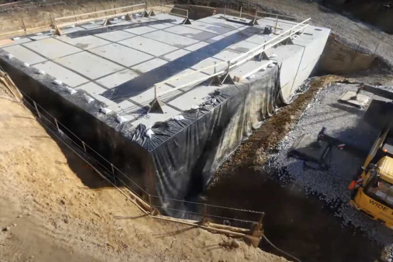
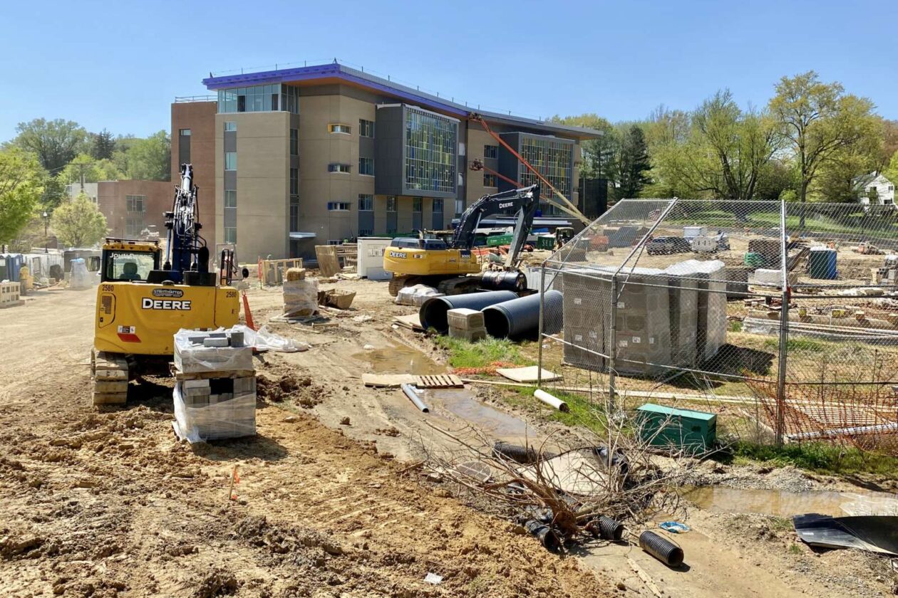
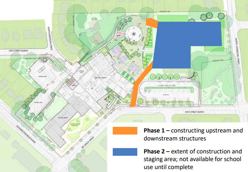
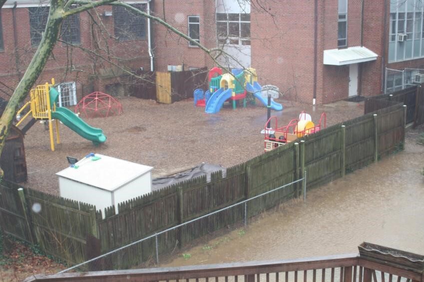
A large, $18 million stormwater vault underneath Cardinal Elementary School in the flood-prone Westover neighborhood is now complete.
The vault responds to community concerns that arose after significant flooding washed over Westover in July 2019.
Arlington County will mark the completion of the vault with a ribbon-cutting this Saturday during a neighborhood festival at the school, dubbed Westover Day. Beyond celebrating the completed vault, Westover Day will also mark the completion of the new school building, athletic field and playground with school tours, live music and food trucks.
The 47,000-square-foot vault is part of the county’s strategy, dubbed Flood Resilient Arlington, to mitigate the major impacts of flooding. Located in the Torreyson Run watershed, Westover is one of the communities being prioritized for stormwater upgrades.
The vault is designed to hold just over 4 million gallons of stormwater — “equal to six Olympic swimming pools,” according to the county. Its construction, a joint effort by Arlington County and Arlington Public Schools, took two years and was separated into two phases.
First, underground pipes and junction boxes were installed to divert water from an existing storm sewer beneath the school property to where the newly built vault would be, according to the county website. Then, in December 2021, construction of the vault began. It was substantially completed this June.
A video below shows a timelapse of construction through last December.
The athletic fields atop the stormwater vault were closed for sodding but the county tells ARLnow the work is now complete and the fields open.
The ribbon-cutting for the vault at Cardinal Elementary comes on the heels of another county stormwater improvement project.
On Tuesday, county officials celebrated the transformation of the once sludge-filled Ballston Wetland Park into a more robust stormwater filtration system and wildlife refuge.

More Arlington properties could be impacted by 100- and 500-year floods, according to new federal flood insurance rate maps.
The county estimates some 300 buildings, up from 172, now risk a 1% annual chance of being inundated by floods expected to happen once a century. Another 1,150 parcels, up from 1,054, face a 0.2% annual chance of floods that come around every half-millennia.
It identified the probable increase after comparing existing and new floodplain boundaries drawn by the Federal Emergency Management Agency.
In 2020, FEMA proposed new floodplain boundaries and approved them this May, giving Arlington six months to adopt the changes or get booted from its program providing flood insurance to residents, according to a county report.
FEMA also declared emergency services, healthcare facilities and government records storage could no longer be located within 500-year floodplain boundaries, while accessory structures within 100-year floodplain boundaries have to be smaller than 600 square feet and only used for vehicle parking and storage.
Lastly, it created the option, which Arlington is taking, to require greater flood-proofing for the lowest level of structures in 100-year floodplains, also called high-hazard flooding areas. Building to these specifications helps property owners lower their flood insurance premiums, according to the county.
The impacts are “unavoidable,” per the report. The changes are slated to be adopted next month after a public hearing, which the Arlington County Board authorized over the weekend. The new maps, restrictions and building requirements go into effect Nov. 16.
Despite the increases it documented, the county emphasizes the number of affected properties is low.
Only 25% of buildings in a 500-year floodplain, or 150, are non-residential and stand to be potentially impacted by the use restrictions on emergency services, healthcare facilities and government records storage. Some 714 parcels are expected to be impacted by the restrictions on accessory structures.
The report attributes the few affected properties to a longstanding county policy to buy land in floodplains to “discourage unwise development.” Arlington prohibits construction within 15 feet of 100-year floodplain boundaries. FEMA also calls these zones special flood hazard areas and requires owners of property within them to get flood insurance.
“Overall, most parcels and structures within the County are actually not impacted by these new floodplain maps,” Stormwater Communications Manager Aileen Winquist told ARLnow. “Due to Arlington’s extremely forward thinking past policies, many flood prone properties were acquired for parkland.”
The county’s first stormwater plan, from 1957, recommended local government buy land within floodplains.
“Implementation of this recommendation was ahead of its time, and as a result, relatively few properties in Arlington are in the 100-year floodplain,” the county report says. “Instead of large-scale development in the floodplain, Arlington County has an extensive network of stream valley parks as a result of acquisition of stream valleys by the County.”
Crediting these that policy and the prohibition on new building close to flood zones, Arlington County says today, only 300 insurable structures now fall in FEMA’s new high-risk 100-year floodplain areas, comprising 0.6% of all structures in Arlington. Another 150 buildings are within 15 feet of the same boundaries.
The county contrasts itself with other jurisdictions that have relied more on flood-control infrastructure, such as levees, and disaster relief for flood victims.
“This approach did not reduce losses… and this strategy did not discourage unwise or risky development,” the report said. “In fact, it may have actually encouraged additional development in areas of high risk.”
")
(Updated at 4:20 p.m.) Enjoy the dry weather while it lasts — Saturday is set to be exceptionally wet and windy.
Tropical Storm Ophelia is brewing off the southeast U.S. and is set to make its way up the coast and right over the D.C. area. It will bring with it heavy rain and strong winds.
The rain is expected to start late tonight but the storm will be at its peak Saturday afternoon and evening.
Here in Arlington, flooding along the coastline is expected Saturday, and local streams may also top their banks due to several inches of rain.
“Widespread rainfall amounts of 2 to 4 inches are expected, with localized amounts up to 5 inches possible,” the National Weather Service said in an advisory today. “This may result in isolated instances of flooding, especially for low lying and flood prone areas. The heaviest rain is most likely to occur Saturday into Saturday night.”
Those planning to attend outdoor events this weekend should keep an eye on the weather and monitor for possible cancellations.
The wind, meanwhile, could cause some power outage.
")
NWS issued a Wind Advisory this afternoon for Arlington and other parts of the area, starting Saturday.
…WIND ADVISORY IN EFFECT FROM 8 AM TO 8 PM EDT SATURDAY…
* WHAT…Northeast winds 20 to 30 mph with gusts up to 45 mph expected. Gusts up to 50 mph are likely along the immediate shore of the Chesapeake Bay and Tidal Potomac.
* WHERE…Portions of central, northeast and southern Maryland, The District of Columbia and central and northern Virginia.
* WHEN…From 8 AM to 8 PM EDT Saturday.
* IMPACTS…Gusty winds could blow around unsecured objects. Tree limbs could be blown down and a few power outages may result.
* ADDITIONAL DETAILS…The combination of a long period of gusty winds and increasingly saturated grounds from rain will result in a higher likelihood for downed trees across the area.
NWS also previously issued Coastal Flood watches and advisories.
District of Columbia-Arlington/Falls Church/Alexandria-
850 AM EDT Fri Sep 22 2023…COASTAL FLOOD ADVISORY IN EFFECT FROM MIDNIGHT TONIGHT TO 6 AM EDT SATURDAY…
…COASTAL FLOOD WATCH NOW IN EFFECT FROM SATURDAY MORNING THROUGH LATE SATURDAY NIGHT…* WHAT…For the Coastal Flood Advisory, up to one half foot of inundation above ground level expected in low lying areas due to tidal flooding. For the Coastal Flood Watch, up to one foot of inundation above ground level possible in low lying areas due to tidal flooding.
* WHERE…Shoreline in the District of Columbia, Arlington County, and the City of Alexandria.
* WHEN…For the Coastal Flood Advisory, from midnight tonight to 6 AM EDT Saturday, especially around the time of high tide. For the Coastal Flood Watch, from Saturday morning through late Saturday night, especially around the time of high tide.
* IMPACTS…Shoreline inundation is expected along portions of the seawall adjacent to Ohio Drive and the Hains Point Loop Road and near the Tidal Basin. Water is expected to approach the curb near the intersection of King Street and Strand Street in Alexandria.
* ADDITIONAL DETAILS…Tides one and a half to two feet above normal. The next high tide at Alexandria is at 1:59 PM and 2:19 AM. The next high tide at Washington Channel is at 1:41 PM and 2:01 AM.
PRECAUTIONARY/PREPAREDNESS ACTIONS…
If travel is required, allow extra time as some roads may be closed. Do not drive around barricades or through water of unknown depth. Take the necessary actions to protect flood-prone property.
While areas to the east are expected to see more significant impacts, local chapters of the American Red Cross said this morning that they’re gearing up for a disaster response.
More, below, via a press release.
")
Update at 4:30 p.m. — Arlington is now also under a Severe Thunderstorm Watch until 11 p.m.
A Severe Thunderstorm Watch has been issued for parts of the area through 11PM this evening. Damaging winds and hail are the main threats. Be sure to seek shelter as numerous storms are ongoing across the area. #DCwx #VAwx #MDwx #WVwx pic.twitter.com/SSicDxldck
— NWS Baltimore-Washington (@NWS_BaltWash) September 9, 2023
Earlier: As storms move in, Arlington is now under a Flood Watch until midnight tonight.
The watch was issued around 2:45 p.m. for the county and much of the D.C. area. Forecasters say several rounds of slow-moving storms may cause flooding in low-lying areas and near creeks and streams.
The Rosslyn Jazz Festival, meanwhile, has been paused while this round of storms moves through.
⚠️ #RosslynJazz Festival is on pause as weather comes through the area. Please take shelter. We will post events updates as they come. https://t.co/2EC8HsNo9B
— Rosslyn, Virginia (@RosslynVA) September 9, 2023
More from the National Weather Service:
Flood Watch
National Weather Service Baltimore MD/Washington DC
243 PM EDT Sat Sep 9 2023…FLOOD WATCH IN EFFECT UNTIL MIDNIGHT EDT TONIGHT…* WHAT…Flash flooding caused by excessive rainfall continues to be possible.
* WHERE…Portions of DC, including the following , District of Columbia. Portions of Maryland, including the following areas, Anne Arundel, Central and Southeast Howard, Central and Southeast Montgomery, Northern Baltimore, Northwest Howard, Northwest Montgomery, Prince Georges and Southern Baltimore. Portions of northern Virginia, including the following areas, Arlington/Falls Church/Alexandria, Central and Southeast Prince William/Manassas/Manassas Park, Eastern Loudoun, Fairfax and Northwest Prince William.
* WHEN…Until Midnight EDT tonight.
* IMPACTS…Excessive runoff may result in flooding of rivers, creeks, streams, and other low-lying and flood-prone locations. Flooding may occur in poor drainage and urban areas.
* ADDITIONAL DETAILS…
– Several rounds of slow moving showers and thunderstorms are possible through this evening. Rainfall rates of 1 to 2 inches in an hour may lead to flash flooding, especially in poor drainage and urban areas.
– Please visit www.weather.gov/safety/flood for flood safety and preparedness information.PRECAUTIONARY/PREPAREDNESS ACTIONS…
You should monitor later forecasts and be prepared to take action should Flash Flood Warnings be issued.
Last week, residents may have received a postcard outlining a new tax they can expect next year: a stormwater utility fee.
Like electric, gas, or water utility bills, this fee effective Jan. 1, 2024, would charge properties a fee based on use of and impact on Arlington County’s stormwater system. The new fee will replace an existing sanitary district tax calculated based on property assessments.
Residents of properties with more hard surfaces that do not let rain soak into the ground — such as roofs and driveways — can expect to pay larger fees than those with fewer such surfaces. Property owners can receive credits for steps they take to reduce stormwater runoff.
Revenue from the fee will fund stormwater capital projects — to the tune of $331 million over the next decade. To mitigate flooding, Arlington is also buying properties in flood-prone areas, adding stormwater detention vaults and making small drainage improvements, among other projects.
“The County is making this change now because the rise in severe flooding in recent years requires us to increase investments in our stormwater system, and a utility is a fairer way to distribute the cost,” per the county website. “These investments will help maintain, upgrade, and scale our stormwater infrastructure to better protect Arlington from future severe rainstorms.”
The Arlington County Board approved the fee with the 2024 budget earlier this year. It comes on the heels of a 2020 study by a consultant that recommended the switch and further study by staff.
The new model is fairer, says Arlington County, because it found property assessments were “weakly correlated” to impervious surface and these impermeable areas are “a better estimate of usage of the stormwater assessment.”
Before, the sanitary tax amounted to $0.017 per $100 of assessed value, or $136 a year for a home assessed at $800,000. Now, single-family homes could see a similar starting point for the stormwater utility fee, of $138 for homes under 1,600 square feet, with fees increasing as square footage increases.
Apartment and condo dwellers could see a flat rate of around $45.
This fee is based on a unit of measure Arlington County devised, called an “Equivalent Residential Unit.” The county calculated this by finding the average impervious coverage for single-family detached properties, which is 2,400 square feet.
Currently, one ERU is roughly $230-250, according to the county, though the final rate for 2024 will be set this fall and annually thereafter. Property owners would be charged based on how many ERUs compose their property. They can estimate that fee using a tool the county created.

People looking for some relief can apply for a credit program that rewards voluntary actions such as adding rain gardens. From Nov. 1 through Jan. 15, all property owners can apply for voluntary credits to offset up to 35% of their bill, or about $80 per ERU.
“The credit program is not a bill assistance program, but rather a thank you to customers for doing the right thing for the environment,” the county website says.
")
(Updated at 2:15 p.m.) For the second day in a row Arlington is under a Flood Watch.
The National Weather Service says that “anomalous moisture coupled with the potential for multiple slow moving thunderstorms will result in the potential for flash flooding.” The storms are expected to arrive later this afternoon, with the Flood Watch set to expire at 8 p.m.
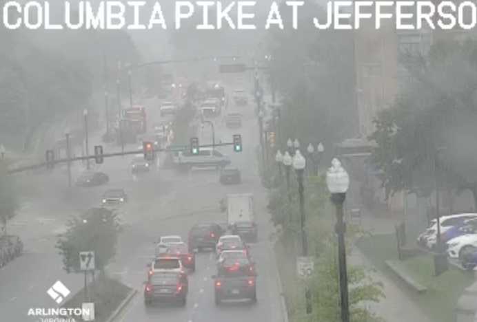
The flood potential follows storms yesterday (Monday) that prompted Tornado, Severe Thunderstorm and Flash Flood warnings all in the span of about 10 minutes. The heavy rain also flooded a busy intersection along Columbia Pike.
Later Tuesday afternoon a Severe Thunderstorm Watch was issued as well.
More on today’s Flood Watch, below, from NWS.
Flood Watch
National Weather Service Baltimore MD/Washington DC
1229 PM EDT Tue Aug 15 2023…Flash flooding will be possible this afternoon into the early evening, particularly for areas which were hit on Monday by very heavy rainfall…
…FLOOD WATCH IN EFFECT UNTIL 8 PM EDT THIS EVENING…
* WHAT…Flash flooding caused by excessive rainfall is possible.
* WHERE…Portions of DC, Maryland and northern Virginia, including the following areas: in DC, District of Columbia. In Maryland, Anne Arundel, Central and Southeast Howard, Central and Southeast Montgomery, Northwest Howard, Northwest Montgomery, Prince Georges and Southern Baltimore. In northern Virginia, Arlington/Falls Church/Alexandria and Fairfax.
* WHEN…Until 8 PM EDT this evening.
* IMPACTS…Excessive runoff may result in flooding of rivers, creeks, streams, and other low-lying and flood-prone locations. Flooding may occur in poor drainage and urban areas.
* ADDITIONAL DETAILS…
– Given the antecedent conditions in place across portions of the D.C. metro area, additional heavy rainfall today will enhance the threat for further flash flooding issues. Hourly rainfall rates of 1.50 to 2.00 inches are possible in the heaviest downpours. Thunderstorms may be slow to move initially before becoming more progressive later in the afternoon.
– Please visit weather.gov/safety/flood for flood safety and preparedness informationPRECAUTIONARY/PREPAREDNESS ACTIONS…
You should monitor later forecasts and be prepared to take action should Flash Flood Warnings be issued.
A Flood Watch for the potential for flash flooding has been issued for the DC and Baltimore Metros from 2 PM until 8 PM today. Anomalous moisture coupled with the potential for multiple slow moving thunderstorms will result in the potential for flash flooding. pic.twitter.com/i0tUPw9e1m
— NWS Baltimore-Washington (@NWS_BaltWash) August 15, 2023
More on the Severe Thunderstorm Watch, below.
A severe thunderstorm watch has been issued for parts of DE, DC, MD, NJ, NC, PA, VA until 9 PM EDT pic.twitter.com/vTJB942glu
— NWS Severe Tstorm (@NWSSevereTstorm) August 15, 2023
Most of the I-95 corridor has been upgraded to a Slight Risk for Severe Weather from the Storm Prediction Center for thunderstorms that are expected to move through this afternoon into this evening. Have multiple methods of receiving warnings. Latest: https://t.co/5RyZgpfrqr pic.twitter.com/mGMeTBHFAY
— NWS Baltimore-Washington (@NWS_BaltWash) August 15, 2023
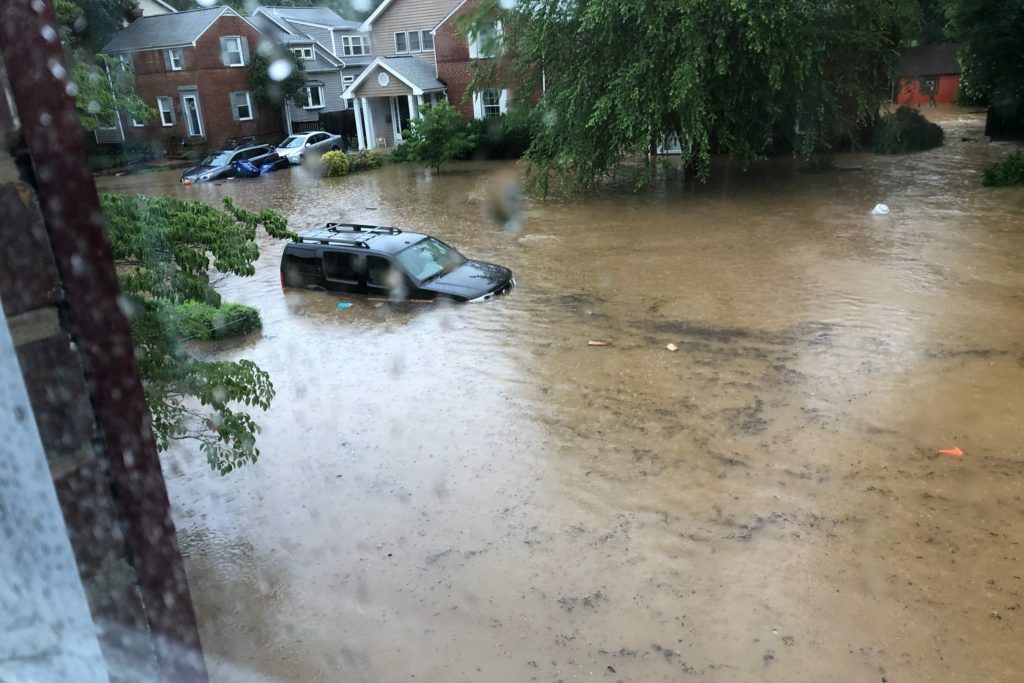
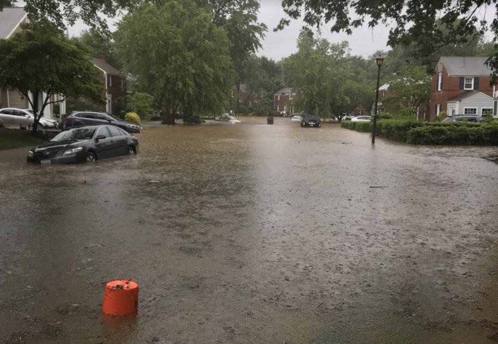
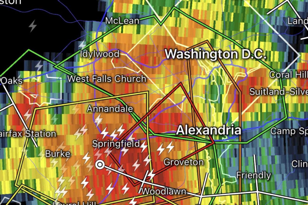
(Updated at 5:25 p.m.) A Tornado Warning was issued for part of Arlington and the entire county is under Flash Flood and Severe Thunderstorm warnings.
The warnings were all initially issued between about 4:15-4:25 p.m., with forecasters saying there was imminent danger of a tornado in parts of South Arlington and flash flooding throughout the county.
The Tornado Warning was cancelled shortly after 4:30 p.m., though the other warnings remained in effect and have since been updated with newer information.
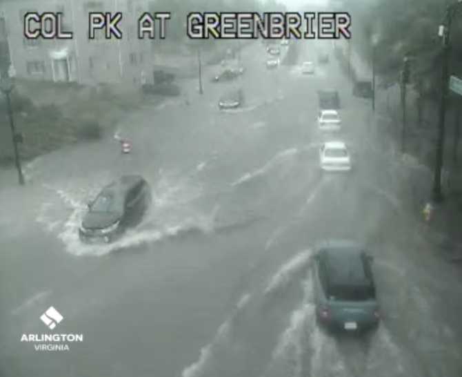
As of 4:50 p.m. flooding could be seen occurring on Columbia Pike at S. Greenbrier Street — a frequent problem spot — with high standing water in the roadway and some motorists trying to drive through it while others were seen turning around. As of 5 p.m. much of the water had receded.
Video: The journey of a traffic barrel across Columbia Pike amid flooding at S. Greenbrier Streethttps://t.co/SqlWcbD75D pic.twitter.com/mA2pgZGaRa
— Arlington Now (@ARLnowDOTcom) August 14, 2023
Ponding was also seen in the usual problem spots on I-395.
Flooding in usual spot. I-395N across from the Pentagon. Some think they're on an amusement park ride. Others just want to make the biggest splash. Neither are smart ways to approach this. @VaDOTNOVA @ARLnowDOTcom @capitalweather @dougkammerer #weather #flashfloodwarning #395cam pic.twitter.com/1sQqLI4BuM
— Dave Statter (@STATter911) August 14, 2023
More on the flash flooding from the National Weather Service:
The National Weather Service in Sterling Virginia has issued a
* Flash Flood Warning for… Southeastern Arlington County in northern Virginia… Southeastern Fairfax County in northern Virginia… The City of Alexandria in northern Virginia…
* Until 745 PM EDT.
* At 436 PM EDT, emergency management reported thunderstorms producing heavy rain in in the Springfield area. Between 1 and 3 inches of rain have fallen. Additional rainfall amounts of 0.5 to 1 inch are possible in the warned area. Flash flooding is already occurring.
HAZARD…Life threatening flash flooding. Thunderstorms producing flash flooding.
SOURCE…Emergency management reported.
IMPACT…Life threatening flash flooding of creeks and streams, urban areas, highways, streets and underpasses.
Also from NWS, as of 5 p.m., on the storms:
…THE SEVERE THUNDERSTORM WARNING FOR THE DISTRICT OF COLUMBIA… SOUTHERN MONTGOMERY…WEST CENTRAL PRINCE GEORGES…ARLINGTON…AND EAST CENTRAL FAIRFAX COUNTIES AND THE CITY OF ALEXANDRIA WILL EXPIRE AT 500 PM EDT…
The storm which prompted the warning has moved out of the area. Therefore, the warning will be allowed to expire. However gusty winds and heavy rain are still possible with this thunderstorm. To report severe weather, contact your nearest law enforcement agency. They will relay your report to the National Weather Service Sterling Virginia.
Severe Thunderstorm Warning including Washington DC, Arlington VA and Alexandria VA until 5:00 PM EDT pic.twitter.com/TGaRBOkVZy
— NWS Baltimore-Washington (@NWS_BaltWash) August 14, 2023
Tornado Warning including Springfield VA, Lincolnia VA and Rose Hill VA until 4:45 PM EDT pic.twitter.com/clR12BZw2x
— NWS Baltimore-Washington (@NWS_BaltWash) August 14, 2023
Flash Flood Warning including Washington DC, Arlington VA and Alexandria VA until 8:00 PM EDT pic.twitter.com/D6giSx6QNa
— NWS Baltimore-Washington (@NWS_BaltWash) August 14, 2023