")
Several rounds of storms packing heavy downpours are possible tonight, leading to a Flood Watch being issued for Arlington and much of the region.
The watch is in effect until 4 a.m. Thursday.
Flash flooding and gusty winds are possible tonight, the National Weather Service says.
In Arlington, flooding is often limited to ponding on roadways and streams overtopping their banks, but some past summer rain storms have resulted in widespread flash flooding and numerous flooded basements.
From NWS:
…FLOOD WATCH IN EFFECT UNTIL 4 AM EDT THURSDAY…
* WHAT…Flash flooding caused by excessive rainfall is possible.
* WHERE…Portions of DC, Maryland, Virginia and panhandle West Virginia, including the following areas: in DC, District of Columbia. In Maryland, Anne Arundel, Central and Southeast Howard, Central and Southeast Montgomery, Frederick MD, Northwest Howard, Northwest Montgomery, Prince Georges and Washington. In Virginia, Arlington/Falls Church/Alexandria, Clarke, Eastern Loudoun, Fairfax, Frederick VA and Western Loudoun. In panhandle West Virginia, Berkeley, Jefferson and Morgan.
* WHEN…Until 4 AM EDT Thursday.
* IMPACTS…Excessive runoff may result in flooding of rivers, creeks, streams, and other low-lying and flood-prone locations.
* ADDITIONAL DETAILS…
– Numerous showers and thunderstorms with heavy rain are expected through this evening and into the overnight. Rainfall rates of 2 inches per hour are possible, leading to the potential for flash flooding especially in areas that see multiple rounds of heavy rain.
– Please visit https://www.weather.gov/safety/flood for flood safety and preparedness information.PRECAUTIONARY/PREPAREDNESS ACTIONS…
You should monitor later forecasts and be prepared to take action should Flash Flood Warnings be issued.
The Flood Watch this evening has been expanded (areas in green), for the potential of flash flooding, with the possibility of gusty winds. Stay weather aware and see https://t.co/Kt74D8dUsR for the latest. #DCwx #MDwx #VAwx #WVwx pic.twitter.com/VpSzy4TqI4
— NWS Baltimore-Washington (@NWS_BaltWash) June 8, 2022
")
Arlington is under a Flood Watch until early Saturday.
Rain, which will be heavy at times, will fall throughout most of the day, raising the possibility of flooding, particularly near streams and low-lying areas.
The Flood Watch is in effect until 2 a.m.
More from the National Weather Service, below.
…FLOOD WATCH IN EFFECT FROM THIS AFTERNOON THROUGH LATE TONIGHT…
WHAT…Flooding caused by excessive rainfall is possible.
WHERE…DC and portions of Maryland and northern Virginia, including the following areas: the District of Columbia. In Maryland, Anne Arundel, Central and Southeast Howard, Central and Southeast Montgomery, Northwest Howard, Northwest Montgomery, Prince Georges and Southern Baltimore. In northern Virginia, Arlington/Falls Church/Alexandria, Eastern Loudoun, Fairfax, Northern Fauquier, Prince William/Manassas/Manassas Park and Western Loudoun.
WHEN…From this afternoon through late tonight.
IMPACTS…Excessive runoff may result in flooding of rivers, creeks, streams, and other low-lying and flood-prone locations.
ADDITIONAL DETAILS… – Widespread rainfall totals of 1-3 inches are expected through tonight. This may lead to localized instances of flooding. – http://www.weather.gov/safety/flood
PRECAUTIONARY/PREPAREDNESS ACTIONS… You should monitor later forecasts and be alert for possible Flood Warnings. Those living in areas prone to flooding should be prepared to take action should flooding develop.
817a: And so we begin a long, rainy stretch in the DC area. It will remain wet through the weekend. pic.twitter.com/8fGd6BKO6i
— Capital Weather Gang (@capitalweather) May 6, 2022
")
Get ready for a wintry and windy Saturday.
A Winter Weather Advisory and Wind Advisory, both of which take effect Saturday morning, were just issued for Arlington. Forecasters expect wind gusts up to 55 mph and snow accumulation of 2-4 inches as a storm system moves up the East Coast.
From the National Weather Service:
325 PM EST Fri Mar 11 2022
…WINTER WEATHER ADVISORY IN EFFECT FROM 7 AM TO 3 PM EST SATURDAY…
* WHAT…Snow expected. Total snow accumulations of 2 to 4 inches. Northwest winds will gust around 45 to 55 mph.
* WHERE…Portions of central and northeastern Maryland, northern and central Virginia, and the District of Columbia, including most of the DC and Baltimore metros.
* WHEN…From 7 AM to 3 PM EST Saturday. Rain will change to snow between 7 and 9 AM early Saturday. The steadiest snow will be through Saturday morning.
* IMPACTS…Plan on slippery road conditions. Gusty winds could bring down tree branches.
* ADDITIONAL DETAILS…Visibility may be reduced to below one- quarter mile at times. Brief near blizzard conditions are possible between 8 and 11 AM.
PRECAUTIONARY/PREPAREDNESS ACTIONS…
Slow down and use caution while traveling.
When venturing outside, watch your first few steps taken on steps, sidewalks, and driveways, which could be icy and slippery, increasing your risk of a fall and injury.
Also from NWS:
326 PM EST Fri Mar 11 2022
…WIND ADVISORY IN EFFECT FROM 6 AM SATURDAY TO 1 AM EST SUNDAY…
* WHAT…Northwest winds 25 to 35 mph with gusts up to 55 mph.
* WHERE…Portions of northern and central Maryland, northern Virginia, and the District of Columbia including the DC and Baltimore metro areas.
* WHEN…From 6 AM Saturday to 1 AM EST Sunday.
* IMPACTS…Gusty winds could blow around unsecured objects. Tree limbs could be blown down. Several power outages may result.
* ADDITIONAL DETAILS…A few gusts to around 60 mph are possible. Strong winds may persist into early Sunday morning.
PRECAUTIONARY/PREPAREDNESS ACTIONS…
Use extra caution when driving, especially if operating a high profile vehicle. Secure outdoor objects. Prepare for power outages.
The Washington Post’s Capital Weather Gang is a bit more measured in terms of its snow accumulation prediction for Arlington, calling for a coating to 2-3 inches of snow accumulation, with higher amounts north and west.
The storm is expected to start as rain before changing over to snow mid-morning. In such scenarios, snows crews typically do not pre-treat roadways as the treatment would be washed away by the time the frozen precipitation starts.
VDOT said Friday afternoon that its plow crews are ready to tackle the snowy onslaught, while asking drivers to stay at home if at all possible.
VDOT Northern Virginia crews are ready for winter weather that is forecast to impact the region Saturday. The forecast shows precipitation starting as rain and turning to snow. Residents should be ready for high wind gusts and below freezing temperatures.
As always, residents are asked to monitor forecasts and plan ahead to avoid nonessential travel during winter weather.
What’s Happening Now
- See the Winter Weather Advisory from the National Weather Service for precipitation for Saturday. The forecast includes periods of rain and accumulating snow, as well as increased winds. Please continue to monitor forecasts closely as forecasts can improve or worsen quickly.
- Crews will mobilize overnight to treat state-maintained roads. Please drive with caution around plow trucks as they are heavy and move slowly.
- Temperatures are expected to drop below freezing, causing potential icy conditions. Treat anything that looks wet as if it could be icy, especially bridges, ramps, overpasses, and elevated surfaces. If there is snow or ice on roadways, travel is hazardous.
Storm response crews will be ready for possible accumulations/icy conditions from tomorrow's expected late winter event. Remember: Plowing only takes place with at least 2 inches of snow on roads. Know the phases: https://t.co/DuInmBchJW #ArlWX pic.twitter.com/va1nYDBlGh
— Arlington Department of Environmental Services (@ArlingtonDES) March 11, 2022
Winter Weather Advisories have been expanded eastward to include much of the I-95 corridor for Saturday morning. Wind Advisories are also in effect for much of the area. This paired with heavy, wet snowfall could lead to some power outages, especially where heaviest snow falls. pic.twitter.com/Ia9bez8Wt2
— NWS Baltimore-Washington (@NWS_BaltWash) March 11, 2022
")
This week was yet another filled with plenty of news about snow, but unlike previous January weeks not a lot of actual snow.
Using its last traditional snow day allotment, Arlington Public Schools closed Thursday for what turned out to be a bust — a rainy, cold day. Lucky for students looking to enjoy the weather when school’s closed, this weekend should at least be sunny, albeit a little cold, in Arlington.
Now, here are the most-read Arlington articles of the past week.
- Feds release new details about Jan. 6 weapons cache at Arlington hotel
- JUST IN: Winter Weather Advisory issued ahead of Thursday morning snow
- BREAKING: APS closes schools Thursday due to expected snow
- Morning Poll: Should APS continue to require masks in schools?
- The shift from rain to snow delayed in Arlington, NWS decreases possible accumulation
- Guaranteed income pilot program moves forward without any county funding
- NEW: Covid cases falling in Arlington, following regional trends
- Winter Restaurant Week to feature 18 Arlington restaurants
- ‘Old Lee Highway’ gets new name: Cherry Hill Road
- JUST IN: APS says masks still required for students, despite Youngkin’s order
Feel free to discuss those stories or anything else of local interest in the comments. Have a great weekend!
")
Biden Visits Arlington for Vets Day — “President Joe Biden saluted the nation’s military veterans as ‘the spine of America’ on Thursday as he marked his first Veterans Day as president in a wreath-laying ceremony at Arlington National Cemetery.” [WTOP]
Wet Roads Leading to Crashes — From the Washington Weather Geeks: “Please be careful out there this morning! Multiple crashes have been reported in and around the region. Wet [leaves] on the roads will help cause more hazards this morning. Slow down!” [Twitter]
Jury Duty Reminder — “Juror questionnaires were mailed in the form of a postcard with a website link in early August to 35,000 randomly selected residents of Arlington County and Falls Church City. Not everyone was chosen to receive the questionnaire. If you did not receive a postcard, there is nothing you need to do. These Questionnaires are used to qualify residents for jury duty which begins January 1, 2022, and ends December 31, 2022.” [Arlington County]
‘Missing Middle’ Study Update — “The most recent update revealed community support for the housing affordability, diversity, and supply that missing middle housing would bring. Competing concerns from homeowners have arisen regarding flooding, tree loss, and strain on infrastructure; though ultimately, existing patterns of development mean these issues already exist under the status quo.” [GGWash]
‘Spirit of Community’ Honorees — “As Arlington Community Foundation marks three decades of service this fall, this year’s Spirit of Community will honor three extraordinary people who embody Arlington’s Spirit of Community, Advocacy, and Volunteerism. In addition to recognizing these three extraordinary individuals, the program will feature Arlington youth and business leaders who have stepped up to meet the historic challenges of the last two years in inspiring and innovative ways.” [Arlington Community Foundation]
Lots of Ladybugs Around Area — “Multicolored Asian lady beetles are swarming in large numbers across the Mid-Atlantic because of late fall warmth. Also called ladybird beetles, this type of ladybug smells bad, can bite you and, if you squish it, produces a messy, yellow stain. This is another invasive insect that has found a home in our area.” [Capital Weather Gang]
WaPo’s Winter Forecast — “Overall, temperatures should work out close to average. Snow lovers are unlikely to be pleased as we’re projecting below-average amounts for the fifth time in the past six winters. We do, however, think we’ll top last winter’s snow totals… Alexandria, Arlington and Prince George’s counties and the District: 8 to 14 inches.” [Capital Weather Gang]
It’s Friday — Today there will be rain and storms until about 10 a.m., then gradually clearing through this evening. Sunrise at 6:48 a.m. and sunset at 4:56 p.m. Tomorrow there will be a chance of showers between 10 a.m. and 4 p.m., otherwise it will be mostly sunny and breezy, with gusts up to 23 mph. Sunday will be mostly sunny, with a high near 51.
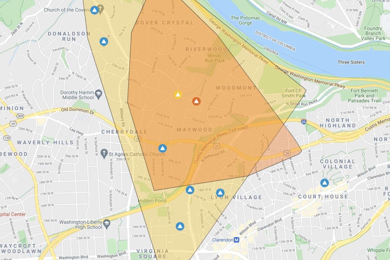
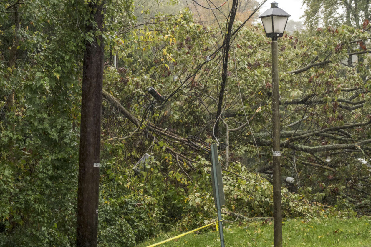
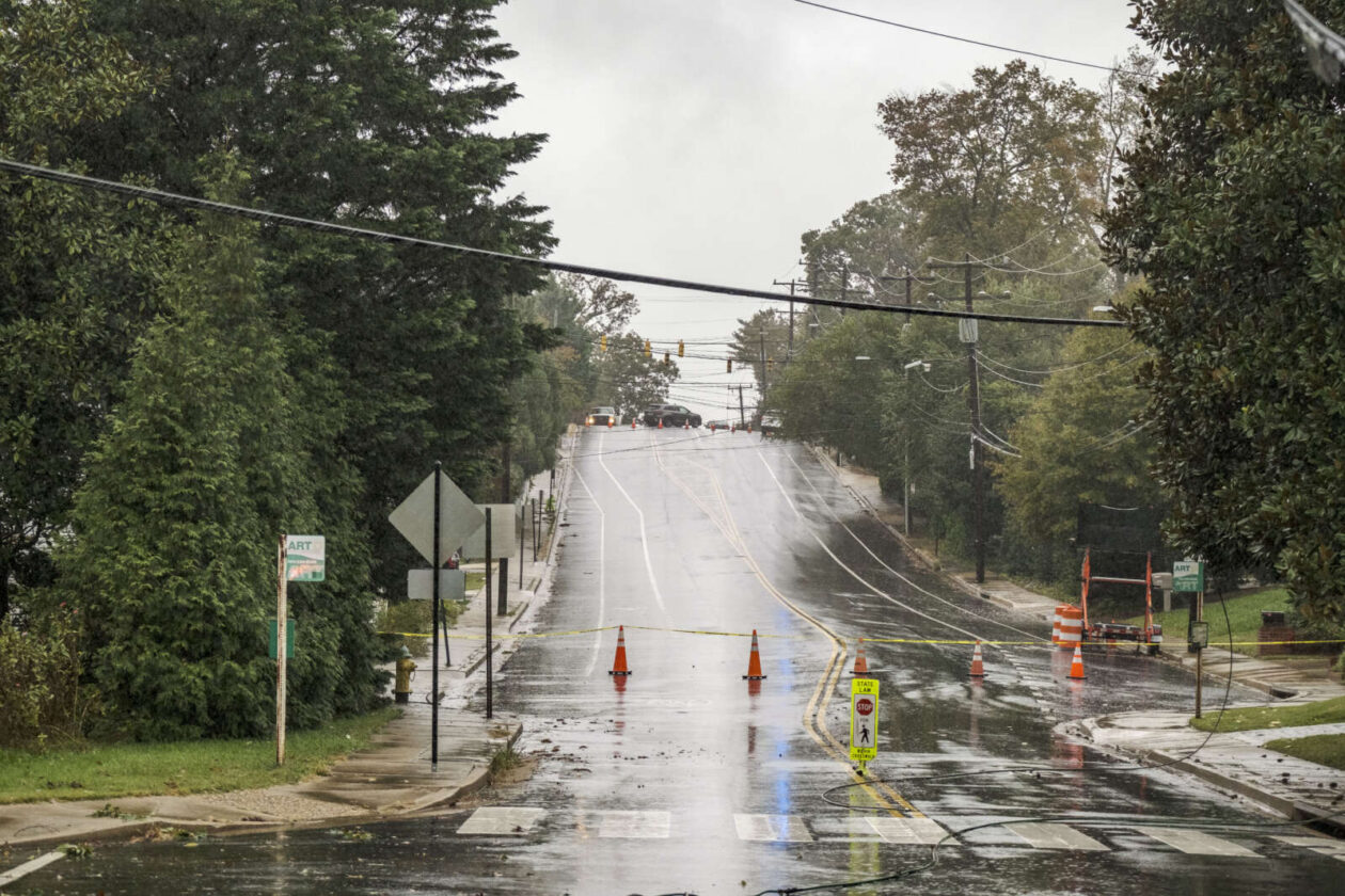
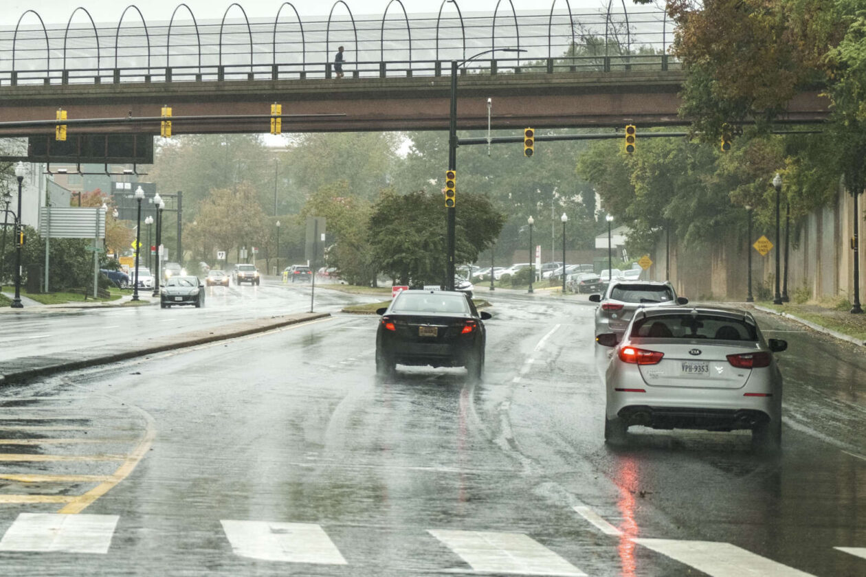
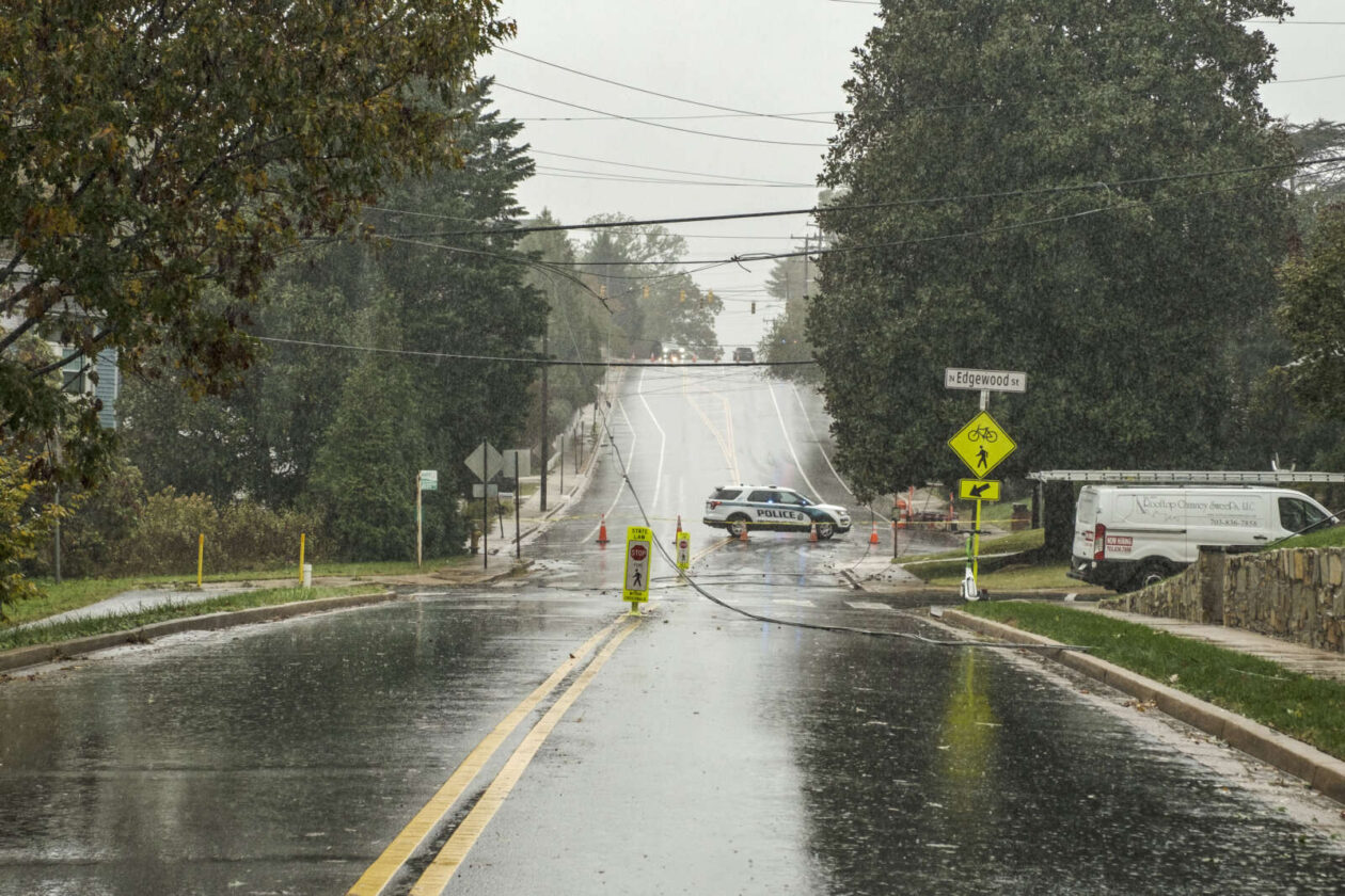
(Updated at 1:25 p.m.) Flooding is not the only imminent threat from today’s wild weather. The saturated ground and gusty winds have brought down several trees and large limbs around Arlington already, causing power outages.
As of 12:30 p.m. more than 2,250 homes and businesses were without power from Virginia Square to Bellevue Forest, with a large chunk of residential North Arlington in between, according to Dominion’s outage map. (The number dipped to 1,925 as of 1:15 p.m.)
Power flickered briefly in Ballston around noon, before coming back on. The outage knocked out traffic signals on Washington Blvd and Langston Blvd, among others. The Lyon Village Shopping Center, including The Italian Store, is also reportedly affected.
One likely cause is power lines that are down across Lorcom Lane near N. Edgewood Street, in the area of the Maywood and Woodmont neighborhoods. A falling tree took down the lines, which Dominion crews are now working to repair. Lorcom Lane is closed in the area.
The current estimated restoration time for the outage is listed as between 2-8 p.m, according to Dominion.
Meanwhile, more trees are likely to fall.
This morning the National Weather Service issued a statement cautioning about falling trees. NWS has received more than a dozen reports of trees falling around the region, including in Fairfax County where more than 5,000 Dominion customers are currently in the dark.
From NWS:
1122 AM EDT FRI OCT 29 2021
…GUSTY WINDS AND WET GROUND LEADING TO MINOR TREE DAMAGE…
GUSTY EASTERLY WINDS OF UP TO AROUND 40 MPH COMBINED WITH WET GROUND FROM RECENT RAINFALL IS RESULTING IN SPORADIC TREE AND POWER LINE DAMAGE. REMAIN ALERT IF TRAVELING THROUGH WOODED AREAS, AND AVOID THEM IF POSSIBLE.
")
It’s going to be nasty, rainy Friday.
Arlington will be under both a Flood Watch and a Coastal Flood Warning tomorrow. On top of that, strong winds and the possibility of some severe thunderstorms are in the forecast.
The Flood Watch takes effect Friday morning. From the National Weather Service:
849 PM EDT Thu Oct 28 2021
…FLOOD WATCH REMAINS IN EFFECT FROM FRIDAY MORNING THROUGH FRIDAY AFTERNOON…
The Flood Watch continues for
* Portions of DC, Maryland and northern Virginia, including the following areas: in DC, District of Columbia. In Maryland, Anne Arundel, Central and Southeast Howard, Central and Southeast Montgomery, Prince Georges and Southern Baltimore. In northern Virginia, Arlington/Falls Church/Alexandria, Fairfax and Prince William/Manassas/Manassas Park.
* From Friday morning through Friday afternoon.
* Rainfall amounts around 1 to 2 inches are most likely with isolated amounts of 2 to 4 inches possible.
* Heavy amounts of rain will cause creeks and streams to slowly rise, possibly out of their banks as well as the potential for flooding in urban areas.
PRECAUTIONARY/PREPAREDNESS ACTIONS…
You should monitor later forecasts and be alert for possible Flood Warnings. Those living in areas prone to flooding should be prepared to take action should flooding develop.
While Arlington’s river shoreline is not developed, unlike our neighbors in Alexandria, significant coastal flooding may inundate trails along the Potomac. A rare Coastal Flood Warning is currently in effect.
…COASTAL FLOOD WARNING NOW IN EFFECT UNTIL 2 PM EDT SATURDAY…
* WHAT…Two to three feet of inundation above ground level expected in low lying areas due to tidal flooding.
* WHERE…Shoreline in the District of Columbia, Arlington County, and the City of Alexandria.
* WHEN…Until 2 PM EDT Saturday, especially around the time of high tide.
* IMPACTS…The unprotected area on the Southwest Waterfront at the DC Seafood Market is expected to flood. Water is expected
to approach parts of the Hains Point Loop Road, but it will likely be closed. Water is expected to approach buildings near King Street and Union Street. Shoreline inundation up to one foot above ground is possible elsewhere.* ADDITIONAL DETAILS…Tides up to 4 feet above normal. The next high tide at Washington Channel is at 2:18 AM and 3:14 PM. The next high tide at Alexandria is at 2:36 AM and 3:32 PM.
PRECAUTIONARY/PREPAREDNESS ACTIONS…
Take the necessary actions to protect flood-prone property. If travel is required, do not drive around barricades or through water of unknown depth.
NWS is calling for wind gusts up to 37 mph tomorrow, raising the possibility of falling trees and branches, as well as power outages.
More via Twitter:
https://twitter.com/ReadyArlington/status/1453742757718200331
Multiple weather concerns for DC area Friday:
* 1-2" of rain, with locally up to 2-4"; pockets of flooding possible.
* Wind gusts of 30-40 mph.
* Biggest coastal flooding for Potomac and Chesapeake Bay since Isabel in 2003https://t.co/pYpkSEuiy5 1/x— Capital Weather Gang (@capitalweather) October 28, 2021
We could see some isolated severe storms tomorrow across parts of the area. Main threat will be damaging winds but an isolated tornado cannot be ruled out across southern MD. #vawx #mdwx #dcwx pic.twitter.com/VvGgATrJXv
— Washingtonian Weather Geeks (@WashingtonianWx) October 29, 2021
")
Update at 10:15 p.m. — Arlington is under a Flood Warning as heavy rain continues to fall. Some flooding is being reported in parts of the area, including along I-66 in Arlington.
high water on I-66 https://t.co/1S6ffP9jG5
— Jordan Tessler (@TerpWeather) October 26, 2021
10:15p: Flood Warnings in effect through late tonight for much of the DC and Baltimore metro areas with scattered reports of flooding, especially in Arlington and Fairfax counties. Heaviest rain should finally shift east of the DMV by around midnight to 1am. pic.twitter.com/oY0JOPB9NK
— Capital Weather Gang (@capitalweather) October 26, 2021
The National Weather Service has issued a Flood Warning for Arlington which is in effect until Tuesday, October 26th at 2:30AM. Don’t risk it!!TURN AROUND, DON’T DROWN. pic.twitter.com/vT1AdGl3UY
— Arlington Fire & EMS (@ArlingtonVaFD) October 26, 2021
Earlier: A rainy night, and possible flooding, is on tap after a line of storms packing gusty winds and downpours blew through Arlington during the evening commute.
More rain is expected to fall on already-saturated ground tonight, prompting the National Weather Service to issue a Flash Flood Watch.
More from NWS:
URGENT – IMMEDIATE BROADCAST REQUESTED
FLOOD WATCH
NATIONAL WEATHER SERVICE BALTIMORE MD/WASHINGTON DC
550 PM EDT MON OCT 25 2021…FLASH FLOOD WATCH IN EFFECT UNTIL 2 AM EDT TUESDAY…
THE NATIONAL WEATHER SERVICE IN STERLING VIRGINIA HAS ISSUED A
* FLASH FLOOD WATCH FOR PORTIONS OF DC, MARYLAND AND NORTHERN VIRGINIA, INCLUDING THE FOLLOWING AREAS: IN DC, DISTRICT OF COLUMBIA. IN MARYLAND, ANNE ARUNDEL, CENTRAL AND SOUTHEAST HOWARD, CENTRAL AND SOUTHEAST MONTGOMERY, PRINCE GEORGES AND SOUTHERN BALTIMORE. IN NORTHERN VIRGINIA, ARLINGTON/FALLS CHURCH/ALEXANDRIA AND FAIRFAX.
* UNTIL 2 AM EDT TUESDAY.
* SHOWERS AND THUNDERSTORMS ARE EXPECTED TO PRODUCE 1 TO 2 INCHES OF RAIN THROUGH THIS EVENING, WITH LOCALIZED AMOUNTS OF UP TO 4 INCHES POSSIBLE. HEAVY RAIN IN A SHORT AMOUNT OF TIME MAY RESULT IN RAPID RISES OF WATER ON SMALL CREEKS AND STREAMS AND IN URBAN AREAS.
PRECAUTIONARY/PREPAREDNESS ACTIONS…
YOU SHOULD MONITOR LATER FORECASTS AND BE PREPARED TO TAKE ACTION SHOULD FLASH FLOOD WARNINGS BE ISSUED.
")
Get ready for another stormy afternoon — and possible flooding.
The National Weather Service has issued a Flash Flood Watch for Arlington and the immediate D.C. region. The watch, which takes effect at 1 p.m., cautions that heavy rain which can cause dangerous, rapid flooding is expected this afternoon and evening.
Yesterday’s afternoon thunderstorm toppled trees around Arlington and knocked out power to several thousand homes and businesses. No significant flooding was reported locally, but the storm left the ground waterlogged and thus increased the chances of flooding today.
More from NWS:
A Flash Flood Watch has been issued for areas along the I-95 corridor this afternoon into tonight. Showers and thunderstorms are likely to bring heavy rainfall, which could lead to instances of flash flooding, especially in urban areas. pic.twitter.com/8TRQXYpqgA
— NWS Baltimore-Washington (@NWS_BaltWash) August 27, 2021
…FLASH FLOOD WATCH IN EFFECT FROM 1 PM EDT THIS AFTERNOON THROUGH THIS EVENING…
The National Weather Service in Sterling Virginia has issued a
* Flash Flood Watch for portions of DC, central Maryland and northern Virginia, including the following areas: in DC, District of Columbia. In central Maryland, Central and Southeast Howard, Central and Southeast Montgomery and Prince Georges. In northern Virginia, Arlington/Falls Church/Alexandria and Fairfax.
* From 1 PM EDT this afternoon through this evening.
* Numerous showers and thunderstorms are expected this afternoon and evening. Average rainfall amounts are expected to be between one half to one inch. However, thunderstorms will be capable of producing very heavy rainfall rates of 2 to 3 inches per hour, causing localized amounts of 2 to 4 inches possible. While storms are possible any time this afternoon through this evening, the most widespread thunderstorm activity is most likely to be late this afternoon through early this evening.
* Heavy rainfall amounts in a short period of time may result in rapid rises on streams and creeks as well as the potential for flash flooding in urban areas.
PRECAUTIONARY/PREPAREDNESS ACTIONS…
You should monitor later forecasts and be prepared to take action should Flash Flood Warnings be issued.
")
Update at 10:15 a.m. — With rain becoming lighter, the Flash Flood Warning has been cancelled, though so far the Flood Warning remains in effect.
LWX cancels Flash Flood Warning for Montgomery [MD] and Arlington, City of Alexandria, City of Falls Church, Fairfax [VA] https://t.co/giUlFCzBzm pic.twitter.com/GBX91Dj7Sn
— Matt Ritter, Multimedia Meteorologist (@MetMattRitter) August 20, 2021
Update at 9:15 a.m. — Heavy rain continues around Arlington, though no major flood-related issues have been reported in the county as of yet. One possibly weather-related incident has closed all lanes of the GW Parkway, however: a tree has fallen across the parkway, blocking all lanes just south of Chain Bridge.
LOCATION: GW Parkway South of Chain Bridge
INCIDENT: Trees Down
IMPACT: All lanes of GW Parkway NB and SB are blocked. Seek Alternate Routes. pic.twitter.com/OLb8UZhFVO— Arlington Alert (@ArlingtonAlert) August 20, 2021
Earlier: Arlington County is under a trio of warnings for rising water this morning.
Arlington is under a Flood Warning and two Flash Flood Warnings, as heavy rain continues throughout the county.
High water and road closures have been reported in parts of D.C. and Fairfax County, according to the National Weather Service.
More on the Flash Flood Warning, which is in effect until noon, from NWS:
Flash Flood Warning including Washington DC, Arlington VA, Friendship Heights MD until 12:00 PM EDT pic.twitter.com/ff0rB05ArF
— NWS Baltimore-Washington (@NWS_BaltWash) August 20, 2021
Flash Flood Warning including Alexandria VA, Rockville MD, Bethesda MD until 12:15 PM EDT pic.twitter.com/DHJEi3Skld
— NWS Baltimore-Washington (@NWS_BaltWash) August 20, 2021
BULLETIN – EAS ACTIVATION REQUESTED
FLASH FLOOD WARNING
NATIONAL WEATHER SERVICE BALTIMORE MD/WASHINGTON DC
755 AM EDT FRI AUG 20 2021THE NATIONAL WEATHER SERVICE IN STERLING VIRGINIA HAS ISSUED A
* FLASH FLOOD WARNING FOR… DISTRICT OF COLUMBIA… SOUTH CENTRAL MONTGOMERY COUNTY IN CENTRAL MARYLAND… NORTHEASTERN ARLINGTON COUNTY IN NORTHERN VIRGINIA…
* UNTIL NOON EDT.
* AT 755 AM EDT, DOPPLER RADAR INDICATED SHOWERS PRODUCING HEAVY RAIN ACROSS THE WARNED AREA. BETWEEN 1 AND 1.5 INCHES OF RAIN HAVE FALLEN. ADDITIONAL RAINFALL AMOUNTS OF 0.5 TO 1.5 INCHES ARE POSSIBLE IN THE WARNED AREA. FLASH FLOODING IS ONGOING OR EXPECTED TO BEGIN SHORTLY.
HAZARD…LIFE THREATENING FLASH FLOODING. SHOWERS PRODUCING FLASH FLOODING.
SOURCE…RADAR.
IMPACT…LIFE THREATENING FLASH FLOODING OF CREEKS AND STREAMS, URBAN AREAS, HIGHWAYS, STREETS AND UNDERPASSES.
* SOME LOCATIONS THAT WILL EXPERIENCE FLASH FLOODING INCLUDE… ARLINGTON… BETHESDA… HOWARD UNIVERSITY… ROSSLYN… FORT TOTTEN… GALLAUDET UNIVERSITY… TAKOMA PARK… CHEVY CHASE… MARTIN’S ADDITIONS… ADAMS MORGAN… GEORGETOWN… AMERICAN UNIVERSITY… FRIENDSHIP VILLAGE… US CAPITOL… BALLSTON… SILVER SPRING… CHILLUM… MOUNT RAINIER… CHEVY CHASE VILLAGE… SOMERSET…
PRECAUTIONARY/PREPAREDNESS ACTIONS…
TURN AROUND, DON’T DROWN WHEN ENCOUNTERING FLOODED ROADS. MOST FLOOD DEATHS OCCUR IN VEHICLES.
BE AWARE OF YOUR SURROUNDINGS AND DO NOT DRIVE ON FLOODED ROADS.
The Flood Warning covers the entire county and other parts of the region:
Here are the latest watches and warnings as of 7:50 AM. There are numerous roads closed due to high water in the Flood Warnings. For the latest warnings: https://t.co/Kt74D7Wj4h #MDwx #VAwx #DCwx #WVwx pic.twitter.com/Nv9l8LvIbc
— NWS Baltimore-Washington (@NWS_BaltWash) August 20, 2021
THE NATIONAL WEATHER SERVICE IN STERLING VIRGINIA HAS ISSUED A
* FLOOD WARNING FOR… DISTRICT OF COLUMBIA… SOUTHEASTERN MONTGOMERY COUNTY IN CENTRAL MARYLAND… NORTHWESTERN PRINCE GEORGES COUNTY IN CENTRAL MARYLAND… ARLINGTON COUNTY IN NORTHERN VIRGINIA… SOUTHEASTERN FAIRFAX COUNTY IN NORTHERN VIRGINIA… THE CITY OF ALEXANDRIA IN NORTHERN VIRGINIA… THE CITY OF FALLS CHURCH IN NORTHERN VIRGINIA…
* UNTIL 145 PM EDT FRIDAY.
* AT 735 AM EDT, DOPPLER RADAR INDICATED HEAVY RAIN. FLOODING IS ONGOING OR EXPECTED TO BEGIN SHORTLY IN THE WARNED AREA. BETWEEN 1 AND 2 INCHES OF RAIN HAVE FALLEN.
* SOME LOCATIONS THAT WILL EXPERIENCE FLOODING INCLUDE… ARLINGTON… ALEXANDRIA… BETHESDA… ANNANDALE… SPRINGFIELD… COLLEGE PARK… FORT WASHINGTON… GREENBELT… LANGLEY PARK… BELTSVILLE… FORT HUNT… GROVETON… FALLS CHURCH… HUNTINGTON… CORAL HILLS… BLADENSBURG… MANTUA… FORT BELVOIR… PIMMIT HILLS… NATIONAL HARBOR…
THIS INCLUDES THE FOLLOWING FLOOD PRONE ROADS:
MILITARY ROAD AT 36TH ROAD AT GULF BRANCH…
18TH STREET AT UPTON STREET…
17TH STREET NORTH AT NORTH BUCHANAN ST…
SOUTH TROY STREET NEAR LONG BRANCH…
WEST STREET NEAR BRADDOCK ROAD…
HOLMES RUN BELOW LAKE BARCROFT…
RHODE ISLAND AVE NE BETWEEN 2ND AND CAPITOL…
BEACH DR FROM BROAD BRANCH RD TO PINEY BRANCH PKWY…
WOODBURN ROAD AT ACCOTINK CREEK…
CONNECTICUT AVENUE JUST NORTH OF THE BELTWAY…
UNIVERSITY BOULEVARD AT SLIGO CREEK…
BEACH DRIVE ALONG ROCK CREEK…
SLIGO CREEK PARKWAY…ADDITIONAL RAINFALL AMOUNTS OF 1 TO 2 INCHES ARE POSSIBLE IN THE WARNED AREA.
PRECAUTIONARY/PREPAREDNESS ACTIONS…
TURN AROUND, DON’T DROWN WHEN ENCOUNTERING FLOODED ROADS. MOST FLOOD DEATHS OCCUR IN VEHICLES.

Arlington is under yet another Flash Flood Watch.
The National Weather Service says that overnight downpours are expected and could cause flash flooding in the D.C. area.
More from NWS:
…FLASH FLOOD WATCH IN EFFECT FROM LATE TONIGHT THROUGH FRIDAY MORNING…
The National Weather Service in Sterling Virginia has issued a
* Flash Flood Watch for portions of DC, central Maryland and Virginia, including the following areas: in DC, District of Columbia. In central Maryland, Central and Southeast Montgomery, Northwest Montgomery and Prince Georges. In Virginia, Albemarle, Arlington/Falls Church/Alexandria, Central Virginia Blue Ridge, Culpeper, Eastern Loudoun, Fairfax, Greene, Madison, Nelson, Northern Fauquier, Northern Virginia Blue Ridge, Orange, Prince William/Manassas/Manassas Park, Rappahannock, Southern Fauquier, Spotsylvania, Stafford and Western Loudoun.
* From 2 AM EDT Friday through Friday morning.
* Scattered to numerous showers and thunderstorms are expected. Although isolated thunderstorms capable of heavy rain are possible this evening near and southwest of the DC metro area, the bulk of the threat is expected to be overnight into Friday morning. Thunderstorms may be capable of producing heavy rainfall of 1 to 2 inches per hour.
* Heavy rainfall may result in rapid rises on streams, creeks, and in urban and poor drainage areas. This will especially be the case where repetitive or persistent thunderstorm activity occurs.
PRECAUTIONARY/PREPAREDNESS ACTIONS…
You should monitor later forecasts and be prepared to take action should Flash Flood Warnings be issued.
Even more rain is expected during the day on Friday and into the weekend.
Conditions generally remain warm and humid the next several days. Each day will bring a chance for afternoon/evening showers and thunderstorms, along with the potential for isolated flooding. #MDwx #VAwx #DCwx #WVwx pic.twitter.com/2cBcwEp176
— NWS Baltimore-Washington (@NWS_BaltWash) August 19, 2021