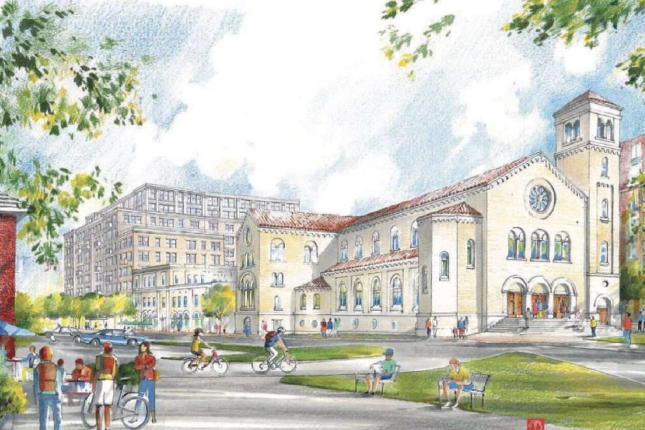
St. Charles Borromeo Catholic Church in Clarendon has filed conceptual designs for a new three-story church and parish center and a 10-story apartment building.
The mid-century church sits on two-and-a-half acres of prime property between the Clarendon and Virginia Square Metro stations, much of it is dedicated to parking.
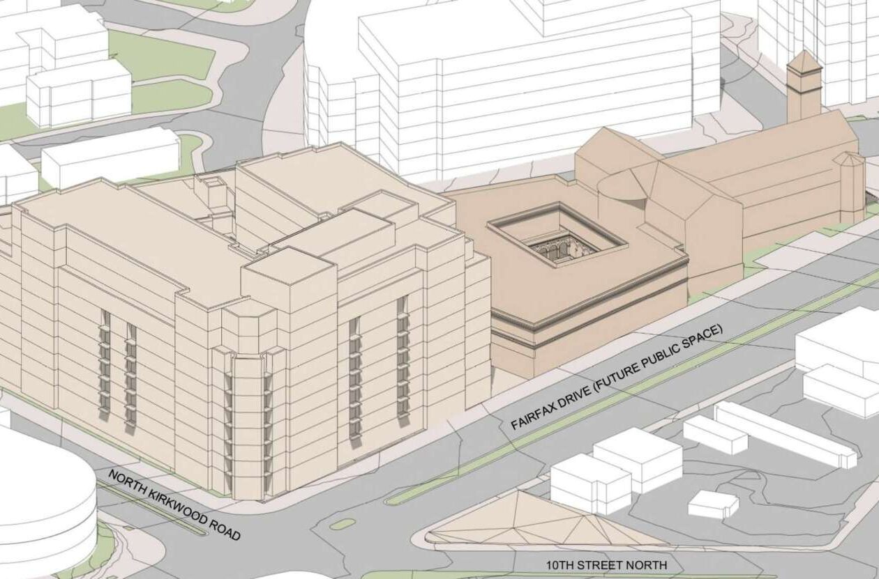
Under the proposal, which has been in the works for a few years now, the 429-unit apartment building will have a courtyard in the center, a rooftop pool and ground-floor amenities. The church will be connected to the parish center, with meeting rooms and an event space, by cloistered gardens.
Parking will move underground and the two structures will be connected by an enhanced alley. Fairfax Drive will be redesigned as a walkable plaza, and there will be a new “West End Plaza” located in front of the church on a county-owned parcel.
But the plans include design elements that could conflict with streetscape design guidelines stipulated by the update to the Clarendon Sector Plan adopted earlier this year. Because of this, the church is seeking the perspective of county planning staff.
“The Applicant desires County feedback on the proposed conceptual plan, and particularly would like to discuss various recommendations of the Clarendon Sector Plan relating to ground-floor transparency, clear walkway zones, and sidewalk grade,” per a letter to the county included in the filings. “Existing site conditions and the programmatic needs of the proposed religious institutional use may complicate full achievement of certain Sector Plan recommendations relating to streetscape design.”
In other words, some elements of the proposed St. Charles Church — which reflect a centuries-long tradition of church architecture — may not align with the sector plan design guidelines for frontages along Washington Blvd and Fairfax Drive.
The streetscape guidelines, aimed at creating an attractive walking experience, call for sidewalks and store entrances to be the same level, without steps, and for storefronts to have mostly transparent windows unobstructed by blinds, fabrics and shelving. These are typified by the streetscapes of The Crossing Clarendon shopping center.
")
“Transparency is a key factor influencing the pedestrian experience: visual access, views to and from interior spaces, and interesting shopfront lighting and displays add visual interest and opportunities for the informal surveillance of public spaces,” per the sector plan.
Like many Roman Catholic churches throughout history, the renderings of St. Charles show an outdoor staircase, doors and a lobby (narthex) separating the sanctuary from casual pedestrian view.
The façades, meanwhile, include stained glass, which typically depict biblical stories and saints. These embellishments are not at pedestrians-scale; rather, they follow in the architectural tradition of drawing the eye upward to aid the worshipper in contemplating heaven.
While the county reviews the designs, the church is bringing a developer partner on board, according to a September church bulletin. The church will lease the land underneath the proposed apartment building to the developer in order to finance the project.
“We continue to refine our cost estimates for the project, but we anticipate that most of our total costs will be met by the proceeds from a long-term lease with our development partner,” parish priest Don Planty writes in the update. “Parishioners will be called upon to contribute to help cover immediate financial needs during planning and in support of sacred art for the new St. Charles church.”
Planty said the planning team estimates further planning, entitlement and permitting will take two years, followed by another two years for construction.

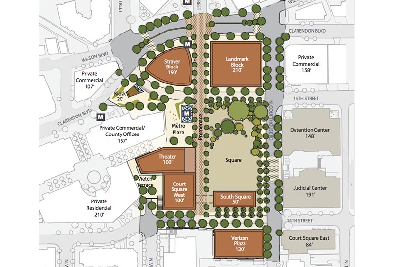
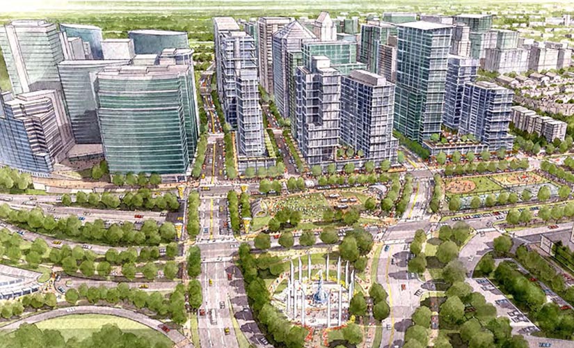
A plan to significantly transform the Courthouse neighborhood by guiding new development, turning the county’s large surface parking lot into a public square and park, and improving Metro access and pedestrian facilities, has gotten the green light.
The Arlington County Board on Monday unanimously approved what it’s hailing as a “visionary” new Courthouse Sector Plan.
“This plan pulls together some of our most successful policies to create a 21st century civic heart for Arlington,” County Board Chair Mary Hynes said in a statement. “It calls for undergrounding Courthouse Square parking to create vibrant open space, improving transit connectivity by adding a new Metro entrance on the square, and improving sustainability through district energy and stormwater management.
“The new Courthouse Square will welcome all Arlingtonians to a new, transparent County administration building, but will also preserve a couple of key historic facades and explore additional cultural amenities in the future,” Hynes added.
A county press release highlighted ten “big ideas” included in the plan:
-
21st Century Civic Square – the top priority replaces an existing surface parking lot to create the new Courthouse Square, a network of open spaces that can support a wide variety of existing and future programs and events. A new parking garage, below the square, will accommodate parking needs.
-
Central Metro access – a new, centrally-located Metro access point will provide a welcoming entrance and serve as a highly visible landmark for visitors.
-
Shared streets – diverse, walkable streetscapes will surround the square and help connect open spaces to the buildings and pedestrian activities in the immediate area. 15th Street North and 14th Street North are envisioned as curbless, shared streets that are uniquely designed to extend the usefulness of the square, accommodate vehicles and transit, while providing priority to pedestrians and promoting safety.
-
Courthouse Square promenade – a key pedestrian connection, between Wilson Boulevard and 14th Street North, will be a vibrant promenade that links the square to activities, Metro, open spaces, County facilities, local businesses and surrounding neighborhoods.
-
Symbolic civic building on South Square – a focal-point building will introduce County, civic, cultural and/or market uses in this prominent location. The future facility should be devoted to highly-accessible community functions or integrated with other compatible civic and cultural activities.
-
Verizon Plaza redevelopment – the existing Verizon Plaza has seen little use in the last several years due to its design, shadows and location. The plan realizes the site as a new development opportunity that will contribute to and further the plan’s goals.
-
County administration building – a key charge for the study was to examine the future location and building massing for a County administration building. The prominent location, adjacent to the promenade and 14th Street North, is on axis with the Judicial Center and provides entrances located on the square.
-
Enhanced pedestrian connection at North Veitch Street and 14th Street North – an improved connection from the south will ease and enrich the pedestrian experience in an area with topographical and visual barriers, and pedestrian conflicts with parking and loading access points.
-
Cultural and civic facilities – cultural and civic facilities have the ability to enliven and enrich the Courthouse Square experience and create a multi-purpose regional destination. A number of locations could accommodate cultural uses ranging from a museum to a performing arts venue. Through the civic engagement process, the community shared a number of potential uses that are included in the document.
-
Sustainability – creative and responsible sustainability solutions are integrated with recommendations throughout the plan.
The sector plan also includes language that supports maintaining affordable housing in the neighborhood, which it described as a “mixed-use, mixed income, premier location.”
The community process for the plan began in 2013. While some elements of the plan could be implemented in the next few years, many of the big goals are expected to take at least five years, if not a decade or more, to bring to reality.
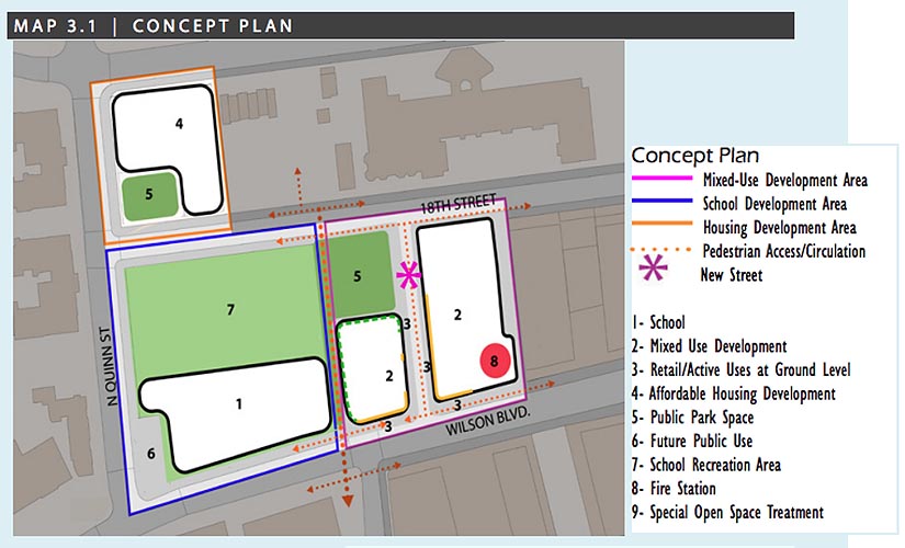
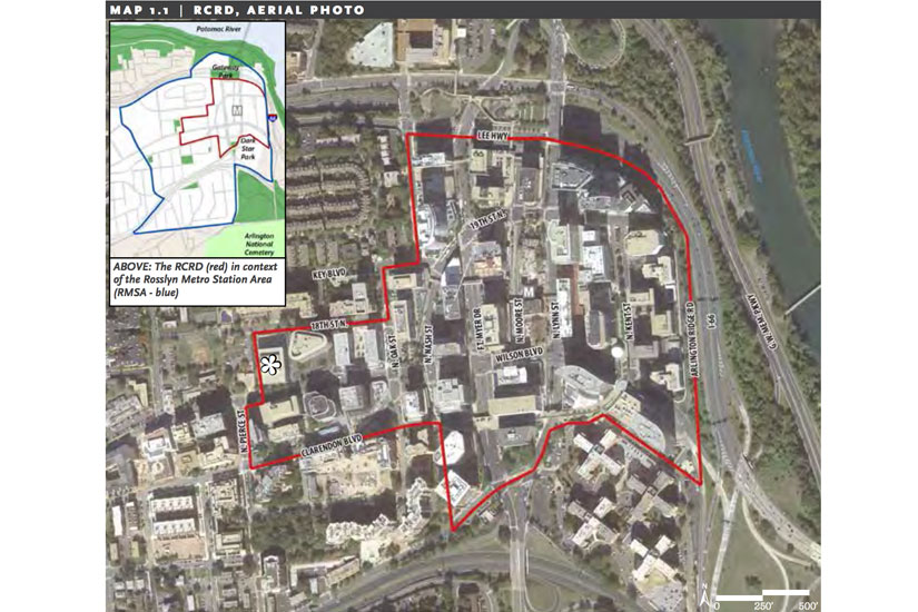
The Rosslyn of the future is envisioned to be more walkable, more dynamic and more green with the County Board’s approval of the Rosslyn Sector Plan and Western Rosslyn Area Plan (WRAP). However, with the approval comes the loss of open space from Rosslyn Highlands Park, which left some residents frustrated with the County Board’s process.
The County Board unanimously approved both plans after hearing resident and staff concerns. Residents generally supported the new sector plan, focused primarily on areas around the Rosslyn Metro station. The Western Rosslyn plan focused on the area around Fire Station #10, up the hill on Wilson Blvd.
It was the Western Rosslyn plan — which calls for a new fire station to be built by a developer, which is in turn building a mixed-use office and residential complex next to it — that attracted the most opposition.
“It is a shame that we felt we needed to pay for the fire station with public land, such an irreplaceable asset, especially here,” said resident Stuart Stein, who was involved with the WRAP study. “This has been an unfortunate process, but it is time to pass this plan.”
The lack of energy from the previously vocal WRAP opponents was reflected in the County Board’s responses. Although they all voted to approve the plan, Vice Chair Walter Tejada said that he came out of the vote “with a sense of resignation, almost, about the open space angle particularly.”
“We do need to move forward, but it really is a good lesson learned,” he said. “We just can’t let this happen again.”
With the Rosslyn Sector Plan, Board members were more enthusiastic.
“It’s been a bit of a marathon, but I think it was a good conversation and I think we have a plan that will work for all of us,” Chair Mary Hynes said.
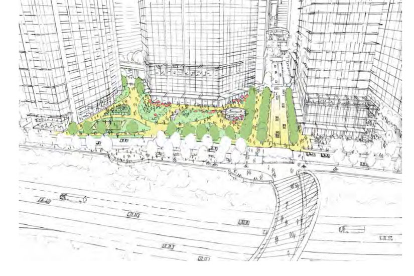
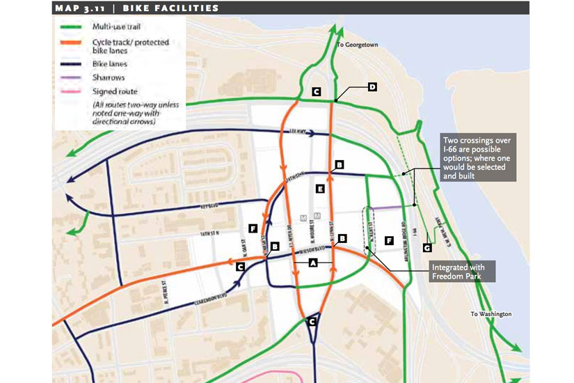
Under the Rosslyn Sector Plan, the neighborhood will get a new open-air Metro entrance, Fort Myer Drive, Lynn Street and Wilson Boulevard will become two-way streets and the county will create a new esplanade that runs along Rosslyn’s eastern edge, connected to the Mt. Vernon Trail via a new pedestrian bridge. It also calls for a corridor along an extended 18th Street, which is envisioned as “a new central spine for Rosslyn.”
Green space has been a big concern for residents under both plans. The Rosslyn Sector Plan calls for a new park and redesign of existing parks, but residents fear that these are empty promises.
“Whether that green space really is developed in the amount that is projected is a question,” Rosslyn resident Diane Gorman said during public comment at yesterday’s recessed County Board meeting.
Parks and Recreation commission member Caroline Haynes urged the County Board members to make sure that plans for open space in Rosslyn were followed, adding that there are limited parks in the neighborhood.
“If we overbuild Rosslyn to the detriment of open space, views and daylight, the built environment will never reestablish those features,” Haynes said. “This plan represents the long-term view for Rosslyn, and should look to achieve long term value for the entire sector, not just for individual land owners and their interests.”
While the Rosslyn Sector Plan looks to create more open space and redesign existing Freedom and Gateway Parks, the Western Rosslyn plan will shrink Rosslyn Highlands Park to rebuild the fire station, a move that prompted residents to rally in protest, pleading with the County Board to save the park.
Under the plan, the county would take away 3,000 to 7,000 square feet of land from the park to allow for the fire station expansion and the Wilson School will be replaced with a larger, 775-seat secondary school building. However, the plan also calls for a 9,000 square foot park to be built across the street at the Queens Court affordable housing complex, which is slated for redevelopment.
The County Board is considering adopting the Rosslyn Sector Plan, but first it is seeking out residents’ opinions.
The Rosslyn Sector Plan is the county’s long-term goal for the neighborhood, including a new Metro entrance, updated parks and a new pedestrian bridge. The County Board authorized two public hearings — one before the Planning Commission on July 6 and the other before the County Board meeting on July 18 — for residents to speak and ask about the new plan.
The county’s vision focuses on four key topics: parks and open space, transportation, building height and urban design.
“The vision that residents, developers, business leaders, property owners and County staff have worked together on for more than two years is truly transformational,” County Board Chair Mary Hynes said. “Once adopted, we believe it will lead to realizing Rosslyn’s full potential. It will ensure that, as Rosslyn continues to grow and develop, it takes it rightful place as another great Arlington urban village – one where people work, live, learn and play.”
The plan comes out of efforts to move Rosslyn from a car-heavy, office-centric area to a walkable, mixed-use urban center, according to a county press release.
To do this, the planning staff have proposed a new 18th Street corridor, extending from N. Oak Street to Arlington Ridge Road. The plan follows the current recommendation to get rid of the skywalk system in Rosslyn, instead focusing pedestrian activity at ground level.
The new 18th Street corridor would be “a new central spine for Rosslyn that will improve linkages to Metro, the future Central Place plaza, and other public spaces and development,” according to the sector plan.
The plan calls for other significant traffic changes. N. Fort Myer Drive, N. Lynn Street and N. Kent Street, currently one-way roads, will be converted to two-way if the sector plan is approved. Also, the Fort Myer tunnel under Wilson Boulevard — which was intended to help the flow of traffic coming over the Key Bridge from D.C. — is to be removed, according to the plan.
“The tunnel’s promotion of high vehicle speeds, highway-oriented character, and incompatibility with a desirable crosswalk of 18th Street across Fort Myer Drive at the Metro station all lead to the recommendation to remove the tunnel and replace it with an at-grade signalized intersection,” according to the plan.
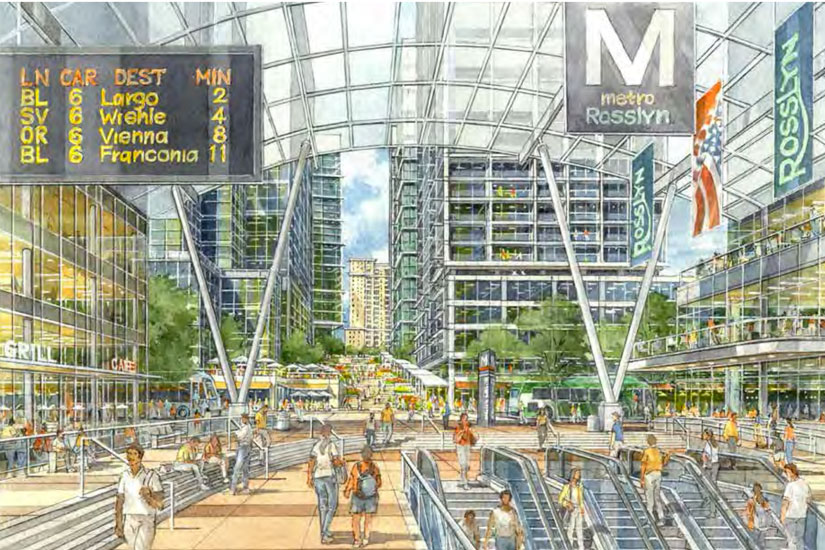
Rosslyn also is looking at a new Metro entrance. The current enclosed space could be transformed into an open air entrance, similar to the entrance at the Foggy Bottom or Van Ness Metro stations. The plaza outside the entrance would extend to Fort Myer Drive and N. Moore Street.
“The Rosslyn Metro Station is centrally positioned within this public space corridor and will serve as an important center of activity and retail concentration,” according to the plan.
While the plan focuses on making Rosslyn more walkable, it also looks to redesign Gateway and Freedom Parks to fit in with the more urban city plan.
Under the plan, the county would remove the current ramp structure at Gateway Park and turn it into a more typical green park setting, with multi-use courts, more lawn space and a playground. Freedom Park will be made more accessible with small-scale recreation areas and outdoor seating for restaurants.
In addition, the plan calls for the future creation of an esplanade that would run along Rosslyn’s eastern edge, extending from Gateway Park to the River Place residential complex along I-66 and then to the Marine Corps Memorial. The esplanade would also overlook the Potomac River. From the esplanade, there would be a pedestrian/cycling bridge that would link it to the riverfront near Roosevelt Island.
While the main construction of the plan is focused on the ground level, the county is also looking to improve the overall look of Rosslyn by adjusting the current height limit to allow for variation in the skyline.
“In addition, the Rosslyn Sector Plan sets forth a new building heights policy for the RCRD that can more effectively achieve a place with great public spaces, views and view corridors, light and air between buildings, sensitive transitions, and a distinctive and dynamic skyline,” according to the plan.
The county’s long-term vision for Rosslyn includes an open-air Metro entrance, a pedestrian corridor through the heart of the neighborhood, a new pedestrian bridge over the Potomac River and a massive new park.
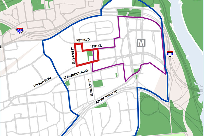
The Realize Rosslyn planning process, which begun in October 2012, has culminated in a draft Rosslyn Sector Plan, which lays out the vision for the area until 2040. That vision includes what’s being called the 18th Street Corridor, which would extend 18th Street from N. Oak Street as a pedestrian corridor with a public escalator to N. Lynn Street, and a road from there to N. Arlington Ridge Road.
“Surrounded by a high density of people and development, these spaces will collectively form a dynamic and memorable promenade weaving through the heart of Rosslyn, and could include features such as public art, festivals, chess tables, outdoor dining, and small recreation courts,” planning staff wrote on the Realize Rosslyn website. “A significant and iconic pedestrian bridge will link a new Esplanade to the Potomac Riverfront near Roosevelt Island.”
In the middle of that planned corridor would sit the Rosslyn Metro Station. As the building that sits on top of it is redeveloped, the Realize Rosslyn panel — made up of residents, business owners and county staff — envisions the enclosed entrance becomes a plaza, with a glass canopy, trees and other amenities.
This corridor would come into being in parts, with Monday Properties’ planned redevelopment of the 1400 Key Blvd and 1401 Wilson Blvd buidings and JBG Companies’ ongoing construction of its Central Place development.
The plan also calls for, by 2040, an additional 4,000-5,000 housing units in the Rosslyn Metro area, 800 of which are either under construction or approved. County planners hope to shrink the percentage of real estate currently occupied by office space, now sitting at 85 percent (with almost 30 percent vacant).
Wilson Blvd, Fort Myer Drive and Lynn Street would also undergo significant changes. Within 10 years, planners anticipate the three one-way streets to convert to two-way roads while removing the Fort Myer Drive tunnel under Wilson Blvd. Wilson, Fort Myer and Lynn would also each have two-way cycle tracks.
The pedestrian bridge to Roosevelt Island would originate from a new Rosslyn Plaza park, a potentially massive open space with recreation activities, an esplanade to the U.S. Marine Corps Memorial and access to a new Key Bridge boathouse.
Meanwhile, Rosslyn’s two biggest parks — Gateway Park and Freedom Park — would be redesigned. Gateway Park’s ramps would be removed and replaced with multipurpose courts and space for food kiosks. Freedom Park, which connects Artisphere’s building to Monday’s twin towers developments on the other side of Wilson Blvd, would become a place restaurants could place outdoor dining.
The Draft Sector Plan will go before the Long Range Planning Committee this month, with a planned hearing in June by the Arlington Planning Commission before the County Board can discuss it.
") The County Board will hold public hearings next month on a framework for the future of Rosslyn.
The County Board will hold public hearings next month on a framework for the future of Rosslyn.
The Rosslyn Sector Plan update — the product of the Realize Rosslyn community planning efforts over the past 15 months — is expected to be adopted by the end of this year, but before that the County Board must hold hearings and approve a framework for the plan. That’s expected to happen next month, after the Board voted to advertise the hearings at its meeting on Tuesday.
Among the biggest changes that could be coming in Rosslyn if the plan is approved is extending 18th Street N. as a pedestrian and bike corridor through Rosslyn’s main stretches — with intersections at Nash Street, Fort Myer Drive, Moore Street and Lynn Street before connecting with N. Arlington Ridge Road — making Fort Myer Drive and Lynn Street two-way roads and removing the tunnels underneath Wilson Blvd.
In addition, the plan will call for utilizing ground floor space for uses other than retail in areas where it would be difficult for stores or restaurants to survive; revitalizing Freedom Park and implementing “active recreational opportunities” in Gateway Park; and increasing housing density in central Rosslyn.
The Realize Rosslyn panel, made up of residents, property owners and government officials, has a stated goal giving Rosslyn a “vibrant 18/7 street life.”
 The proposed 18th Street N. corridor was one of the issues that generated a rift between property owners, specifically the owners of the Ames Center (1820 N. Fort Myer Drive) and Monday Properties, which owns several buildings in Rosslyn including the new, vacant 1812 N. Moore Street skyscraper.
The owners of the Ames Center, in a letter from land use attorney Tad Lunger, said Monday Properties is trying to unduly influence certain aspects of Realize Rosslyn. Lunger said the Ames Center, which houses the Art Institute, is planning on redeveloping into two buildings on either side of the planned 18th Street extension in a straight line from the current 18th Street. Monday Properties’ site plan for the redevelopment of 1401 Wilson Blvd and 1400 Key Blvd moves that alignment to the north, Lunger said.
“We are concerned that Monday Properties’ site plan application will preempt the planned alignment of 18th Street before the Rosslyn sector plan update is ever adopted,” Lunger wrote. “The Realize Rosslyn process should guide the Monday Properties site plan, not the other way around.”
Monday Properties President and COO Tim Helmig fired back at Lunger, calling the claims “accusations,” but saying “I will not comment at this time on the specific suggestions and objections in the Lunger Letter.”
“I believe it is without basis to insinuate that Monday Properties role [sic] on the Process Panel has perpetuated a conflicting proposal,” Helmig wrote in a letter to the County Board. “The efforts of Monday Properties as an applicant are in stark contrast to the unfair characterizations within the Lunger Letter.”
Flickr pool photo (top) by ddimick
 The Arlington County Board could approve a study into the sale of air rights over I-66 to private developers this weekend.
The state Office of Transportation Public-Private Partnerships (OTP3) announced in July that it was reaching out to developers to gauge interest in leasing VDOT’s air space over I-66, east of N. Lynn Street in Rosslyn, and over the East Falls Church Metro station.
According to county staff, private developers have expressed enough interest that the county wants to further study the plan. An initial study will be rolled into an amended contract with a planning and preservation firm that is already working on the Realize Rosslyn sector plan update. Depending on the outcome of the initial study, the county could fund more study in the future before a decision is reached to lease the air rights.
The previous contract with the firm had been for $493,544, and the County Board is likely to approve an additional $290,706 for not only assisting county staff with the air rights study, but also for an increased role in Realize Rosslyn.
Realize Rosslyn, a planned update to the Rosslyn Sector Plan, has been in the planning stages since 2011. A Board-appointed panel has been charged with sorting through the community concerns and developing the framework for the future direction of Rosslyn development. The panel was initially supposed to meet six times annually, but it has increased its scope of work and has met closer to 22 times annually.
A framework of the sector plan is expected to go before the Board this April, and county staff hope a full new Rosslyn Sector Plan will be complete by November.
Image via OTP3
 All 12 of the civic associations along Lee Highway in Arlington are forming a partnership to try to shape the future development along the corridor.
With the stated goal of “a more economically vibrant, walkable, attractive Lee Highway corridor — one that benefits neighborhoods and the business community,” representatives from the civic associations have already met with the Arlington County Planning Commission for guidance, according to representatives of the Waverly Hills Civic Association.
Along with Waverly Hills, East Falls Church, John M. Langston, Glebewood, Yorktown, Leeway Overlee, Old Dominion, Donaldson Run, Cherrydale, Maywood, and Lyon Village have also joined what the group is calling the “Lee Highway Grassroots Re-visioning.”
Waverly Hills Civic Association President Ginger Brown says the group hasn’t discussed specifics on what the future Lee Highway should look like, calling these first months since the group formed in February “the educational phase,” which includes meetings with the county’s planning staff.
Among the issues the group will be examining and presenting to staff and, they hope, the County Board, will be land use planning and zoning, housing, transportation and parking, demographic trends, tax increment financing and transferable development rights.
“It is anticipated that the new vision will be sent — in early 2015 — to the Arlington County Manager’s office with a request that the County Board appoint and fund a Task Force,” Brown wrote in an email. “Its purpose would be to formally develop a Lee Highway Sector Plan that guides future rezoning and development applications.”
 The first new building proposed under the Crystal City Sector Plan reached Arlington’s Site Plan Review Committee this week.
The gleaming 24-story office building, complete with a unique cantilevered roof, would replace what is now an older government office building that’s nearly vacant as a result of the Base Realignment and Closure Act (BRAC). Under the proposal currently under initial consideration, the existing building — 1851 S. Bell Street — would be torn down and the new building would be built and relabeled 1900 Crystal Drive.
At some 730,000 square feet, we’re told that 1900 Crystal Drive would be the largest private office building in Arlington County. Developer Vornado is hoping to achieve LEED Silver or Gold environmental certification for the building.
 “We’re really excited that such a gorgeous building is [being proposed],” said Crystal City Business Improvement District President and CEO Angela Fox. “It’s a bold statement about where Crystal City is headed.”
(Disclosure: Crystal City BID is an ARLnow.com advertiser.)
Up the road, changes are in the works for another existing office building along Crystal Drive.
The building known as Jefferson Plaza One, which has also been affected by BRAC, is expected to be renovated starting this spring.
The building will be “re-skinned” with a largely glass exterior and will be relabeled 1400 Crystal Drive. Building owner Lowe Enterprises has scheduled a groundbreaking event for the project on March 29.
 The Aurora Highlands Civic Association is asking the Arlington County board to delay a scheduled vote on a sweeping, 40-year development plan for Crystal City, to allow more time for resident review.
The board is scheduled to vote on the Crystal City Sector Plan at its 6:30 p.m. meeting tonight. But Aurora Highlands urban planning committee chairman Ted Saks says the county was unable to deliver an updated version of the plan to the association’s emergency meeting last night, prompting the call for a delay.
Saks says a meeting with County Manager Michael Brown two weeks ago has produced positive changes, including pledges of a traffic monitoring plan, a citizen advisory board, and a study of ways to smooth the transition from the high-density development that will surround Route 1 and the single-family home neighborhood to the west.
However, since the county could not deliver a final version of the plan that includes those changes, the association is requesting more time for resident review.
It’s unclear whether the board will grant the request.
The Crystal City Sector Plan has been in the works for years, and includes such changes as a new entrance to the Crystal City Metro station, a streetcar line to run along Crystal Drive, dense mixed-use development with ground-floor retail, and changes to the street grid that could result in existing apartment buildings being torn down or significantly modified.
Earlier this year, the Washington Post’s John Kelly shot down Rosslyn’s attempt to brand itself “Manhattan on the Potomac.” You won’t find the word “Manhattan” anywhere in the 156-page Crystal City Sector Plan, but it certainly comes to mind when one sees an artist’s rendering of tall buildings and wide sidewalks surrounding the renamed “Jefferson Davis Boulevard.”
A thriving “see and be seen” street life and a dedicated cultural district are among the goals of planners who hope to convert Crystal City from the workaday home of monolithic government office buildings to an urban oasis of gleaming trophy office towers, shiny new apartment buildings and busy retail corridors.
To achieve the vision of a pedestrian-oriented urban community, however, major investments will need to be made in Crystal City’s inadequate transportation infrastructure — specifically, the roads.
 Currently, Crystal City is surrounded by Crystal Drive on one side, Jefferson Davis Highway on the other, and a disorganized jumble of parallel streets in between. It’s unclear who decided that Clark and Bell Streets should be separate, discontiguous traffic traps, virtually devoid of easily cross-able intersections, but it was obviously someone who, at the time, considered the Crystal City Underground to be the end-all be-all of pedestrian-friendliness.
The sector plan calls for the streets to be combined and “realigned” into a singe, tree-lined “Clark-Bell Street” that will traverse Crystal City top to bottom. Achieving such a realignment will be one of the plan’s biggest challenges. Entire buildings will need to be acquired and torn down to make it happen.
Jefferson Davis Highway, meanwhile, will be utterly transformed into an urban boulevard and will be appropriately renamed “Jefferson Davis Boulevard.” Traffic will be “calmed,” pedestrian crossings will be made safer and, if all goes as planned, the thoroughfare’s current capacity will be maintained.