")
While the pandemic prompted a well-documented exodus to, and development of, sleepy suburban and exurban towns, the Rosslyn Business Improvement District says it has identified a different Covid migration pattern.
About a quarter of Americans reported moving to cities where they could be within a 15-minute walk or bike ride of grocery stores, healthcare and parks, according to a national survey by the BID.
The survey also found 41% plan on moving to be within walking or biking distance of their preferred amenities — including coffee shops, schools and gyms — in the next one to three years. That’s in contrast with places that prioritize mobility by motor vehicle, with sidewalks and bike lanes as a relative afterthought.

The idea of being in a place within a 15-minute walk or bike ride from these amenities, dubbed a “15-minute city,” was developed by French-Colombian academic Carlos Moreno. He says his aim is to “rebalance” localities that have been designed to boost productivity rather than well-being. The Mayor of Paris, Anne Hidalgo, popularized his idea when lockdowns kept people closer to home than usual, and efforts to realize Moreno’s idea took hold there and in other European cities.
Arlington County Planning Commission member Daniel Weir embraces the concept, saying it is better for people and the environment.
“Cities are for people, not cars, and we should be able to get our needs met within a 15-minute walk or bike ride,” he said. “Once upon a time, in living memory for our grandparents, every city in America — from Luray, Virginia to Manhattan — was a 15-minute city. Sometime after the war, we got the idea that cities were about highways and cars, and people had to make way. Now, we’re seeing auto-oriented infrastructure and development is one of the most flawed social experiments of all time.”
Arlington is now trying to at least partially unwind auto-oriented development along Langston Blvd and Richmond Highway, but has yet to tackle the suburban neighborhoods that fall outside its primary planning corridors. Still, the county, which has no singular city center, has had a number of “15-minute cities” spring up through transit-oriented development, which began in the 1960s.
Transit-oriented development created compact urban villages of Rosslyn, Courthouse, Clarendon, Ballston, Pentagon City and Crystal City along the Orange and Blue Metro lines, and is facilitating more development on the bus-connected Columbia Pike.
“The 15-minute city approach is consistent with many facets of the Arlington Comprehensive Plan and is more intrinsic in Arlington’s principles for compact and transit-oriented development,” says Erika Moore, a spokeswoman for Arlington County Dept. of Community Planning, Housing and Development.
Where the pandemic is helping advance the 15-minute city concept in Arlington is via an expansion of uses permitted in the county’s densest zoning districts.
“This is creating potential for expanded uses, including workshop spaces, breweries/distilleries, indoor agricultural such as hydroponics, and animal boarding,” she said. “This blending of retail, restaurants, entertainment, and destination uses, along with offices in smaller, non-traditional formats may prove beneficial to residents living in any of Arlington’s mixed-use corridors or in close proximity to them.”
No longer does a Rosslyn resident, for instance, need to drive to a lower-density part of Arlington to board their pet.
While Rosslyn has transformed from downtown district to 15-minute city, BID President Mary-Claire Burick says the county, property owners and the BID must keep “working together to keep our urban center active and accessible.”
Burick says her organization supports the mixed-use developments and the amenities they’re bringing.
“We support Arlington County’s planned investments in public green space and critical transportation infrastructure — such as the removal of the Fort Myer Tunnel,” she added, “and further building out Rosslyn’s network of pedestrian and bike facilities — which are essential in helping make our amenities even more accessible.”
The BID will focus on “economic resiliency efforts, as well as our community events, programming, and placemaking, all which help create an urban downtown where people want to be,” Burick said.
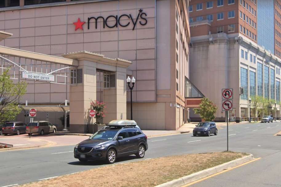
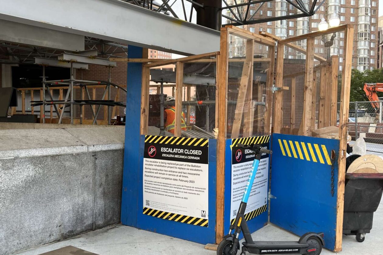
A proposed left-turn lane off of N. Glebe Road in Ballston could be the smallest, yet most scrutinized traffic change in 10 years.
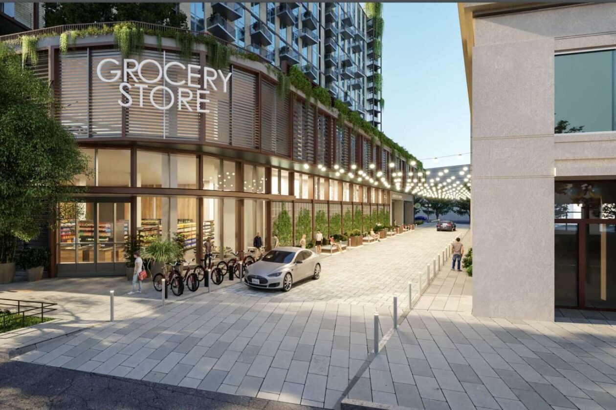
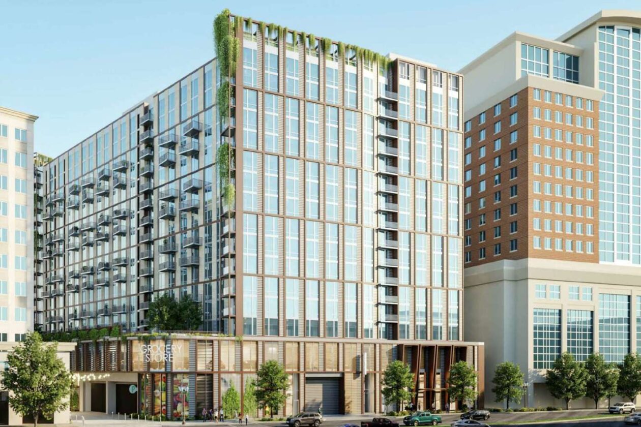
As part of the planned redevelopment of the Ballston Macy’s, Insight Property Group proposes to add a left-turn option at the intersection of 7th Street N. and N. Glebe Road. It will be for drivers going southbound on Glebe who want to turn onto a proposed private drive abutting the planned grocery store, which will be located at the base of Insight’s proposed 16-story, 555-unit apartment building.
“It was the most thoroughly vetted transportation scenario in the time that I’ve been with Arlington County,” transportation planner Dennis Sellin, who has worked with the county for 10 years, told the Planning Commission last night (Monday).

During the meeting, the Planning Commission gave a green light to the redevelopment, which will go before the Arlington County Board for approval later this month.
After the Transportation Commission voted to defer the project solely on the basis of the left turn, Planning Commission members supported a condition for the project that county staff work with Insight and the Virginia Department of Transportation to come up with more pedestrian-oriented options for the intersection.
“I do not think it’s reasonable to hold up the project for this, given that there’s apparently continued good faith work on the intersection to improve its pedestrian-friendliness,” Commissioner Jim Lantelme said. “I want to make clear that the Planning Commission… expects that any option possible to make this intersection more pedestrian-friendly will be pursued.”
Sellin said a half-dozen staffers, including two top transportation officials, have thoroughly vetted the left-turn lane. They published a 64-page memo justifying the turn lane and will study how the grocery store changes traffic before adding any pedestrian mitigation measures.
“There’s a recommendation to not allow any right turns on red at any of the lights in the intersection,” he said. “That’s a movement we’ll take under further consideration. Our primary concern is safety, our secondary concern is operations.”
The left-turn lane is a non-negotiable for the grocer, who has otherwise been “insanely flexible” as the project has changed throughout the public process, according to Insight’s Managing Principal Trent Smith.
“We’ve shrunk their store, changed their ramps, taken away their parking… we changed their loading, we’ve done eight or nine things that took all sorts of reworking and they’ve stuck with us and have been great, reasonable partners throughout,” Smith said.
Insight’s attorney, Andrew Painter, says the unnamed grocer required the left turn based on “decades of experience in urban configurations.” He added that for a decade, the grocer has desired to be in Ballston, which already has a Harris Teeter nearby on N. Glebe Road, a quarter-mile away.
Some Planning Commissioners noted their regret that the project does not do more to provide on-site affordable housing.
“This space here, in the heart of Arlington, in Ballston, where there’s access to transit, and now a grocery store, we have nothing,” Commissioner Devanshi Patel said.
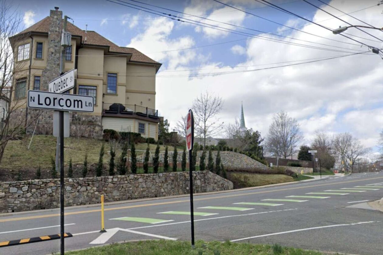
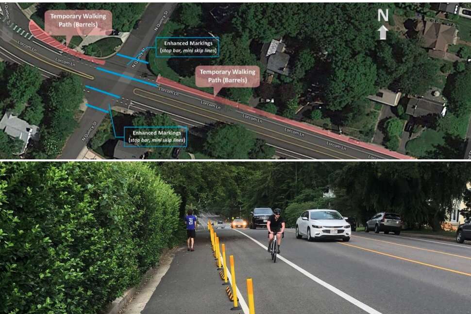
A stretch of Lorcom Lane on the northern edge of the Cherrydale neighborhood is slated to get pedestrian safety upgrades, particularly aimed at improving a school walking route for kids.
Between N. Quebec Street and Nelly Custis Drive, the county will install sidewalks where there are none, widen existing sidewalks and reduce pedestrian crossing distances. Kids walk this stretch of Lorcom Lane to get to Dorothy Hamm Middle School and Taylor Elementary School.
These changes, and others, “originated through community-reported transportation safety concerns, crash data, and the results of the Vision Zero Pilot Safety Project on the north side of this corridor,” per a project webpage.
This summer, a driver struck a woman pushing a stroller at the intersection of Military Road and Lorcom Lane, just west of the corridor slated for improvements. This area had previously been re-striped with the goal of reducing conflicts between drivers and cyclists.
The pilot project responded to safety concerns for the 40% of students who walk or bike to Dorothy Hamm and the 10% who bike to Taylor. Last spring, Arlington Public Schools encouraged kids to walk or bike to school, if they could, to reduce the number of students on the bus, and thus their risk for a Covid exposure.
For kids walking on the northern side of Lorcom Lane between N. Oakland and N. Quebec streets, that meant navigating vehicle and bicycle traffic without a sidewalk. So the county installed temporary parking restrictions to create a dedicated walking path for pedestrians.
Feedback was positive, according to a summary of survey results.
“About 70% of people walking or biking felt safer while traveling here than before the pilot project was implemented,” per the report. “Most respondents for each mode of transportation felt as safe or safer while traveling here than before.”
During a 20-hour period, staff observed about 60 people — nearly one-third of all pedestrians on Lorcom Lane — using the buffered walking path. Nine times out of 10, at least one vehicle drove by when a pedestrian was walking in the buffer area.
Based on that data and positive feedback, staff decided to make the pilot permanent.
Other planned changes include resolving “alignment issues” with the intersection of N. Quebec Street and Lorcom Lane and addressing safety issues at the intersection of Lorcom Lane and Nelly Custis Drive. This intersection is adjacent to a preschool run by Cherrydale United Methodist Church.
There are three other projects within a half-mile radius, including the controversial roundabout pilot project at Military Road and Nelly Custis Drive that could become permanent.
Arlington County also plans to fill in a missing sidewalk at 4100 Nelly Custis Drive and execute a “quick-build” project at N. Quincy Street and Nelly Custis Drive.
This southeast corner of the intersection will get a marked curb extension, while the pedestrian crossing over Nelly Custis Drive will be shortened and the entire intersection will get new, accessible curb ramps. These changes were identified via a safety audit conducted on the Fairfax Drive corridor in 2019.
The project, initially set to be completed this calendar year, won’t be ready until next spring or summer, as county staff are working on an easement there, says Department of Environmental Services spokeswoman Claudia Pors.
")
Arlington County has not ruled out the possibility of a permanent roundabout on Military Road despite the confusion a temporary version has caused for the past year.
In October 2021, where there used to be a stop sign for traffic on northbound Military Road, the county added paint lines, bollards and raised temporary curbs, and partially demolished a median. The work was aimed at improving safety where Military Road intersects with Nelly Custis Drive.
While preliminary data from the county found the roundabout did lower speeds, 53% of drivers, 27% of pedestrians and 26% of cyclists said they felt “less safe” or “much less safe” using the new traffic pattern, per a summary of feedback collected this summer.
“The majority of all respondents reported feeling less safe while using the pilot intersection, but the margins were very narrow for those who walked or biked through the intersection,” the report says. “Those who reported feeling less safe highlighted concerns with operational confusion, the size of the pilot roundabout and the perceived lack of sufficient space for a well-designed roundabout in the future condition.”
Drivers said they were confused about proper procedure in the intersection, while cyclists said drivers exhibited inconsistent behavior and would revert to habits they had when the intersection had a stop sign, per the report. Additionally, several users said the temporary materials caused visual challenges that contributed to the confusion.

About 31% of drivers, 26% of pedestrians and 18% of cyclists said they felt “safer” or “much safer” with the traffic circle, the summary says.
Road users in this camp were also concerned about confusion, but “reported better yield rates by vehicles to pedestrians, slower vehicle speeds, and easier operations for traffic flow and left turns from Military to Military,” the report said.
For now, it seems the roundabout is still in play as a permanent change.
")
The report says that the project can “take the form of either a signalized intersection or a roundabout” and that a majority of issues locals raised “can be addressed through design in a capital project, where the intersection design will not be limited by existing curb lines.”
")
Meanwhile, the Old Glebe Civic Association, which previously called the changes “unwanted” and says it has opposed the potential project for four years, says it has sources claiming the roundabout is all but a done deal.
“Two County staff members recently stated that the County will be building a permanent roundabout, which will take about 12 to 15 months, independent of the public feedback,” writes Peter Jaffe in the October edition of OGCA’s newsletter. “They said that the permanent roundabout will be larger than the temporary one and that the increased size will help address confusion by drivers about who is in the roundabout and who has the right of way.”
The report notes that recently, signs in the middle of the roundabout “have been knocked down and later repaired at least twice, suggesting that incidents have occurred at the roundabout.” The Old Glebe neighborhood is about 2 miles west of the roundabout, but Military Road is a popular commuter route for those heading east.
In response to OGCA’s letter, Dept. of Environmental Services spokeswoman Claudia Pors tells ARLnow there is no official recommendation yet.
“The County has not shared any recommendation or decision for the Military Road and Nelly Custis Roundabout Pilot Project at this time,” she said.
As for the signage, she said the team at DES is aware of the issue.
“Throughout the pilot’s duration, signage has been knocked over,” she said. “Staff has repaired or replaced these signs as soon as possible. We do not have information on the exact causes of these incidents or how many times they occurred.”
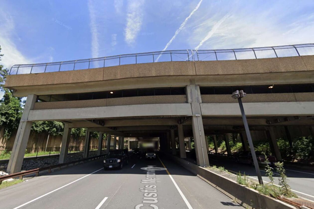
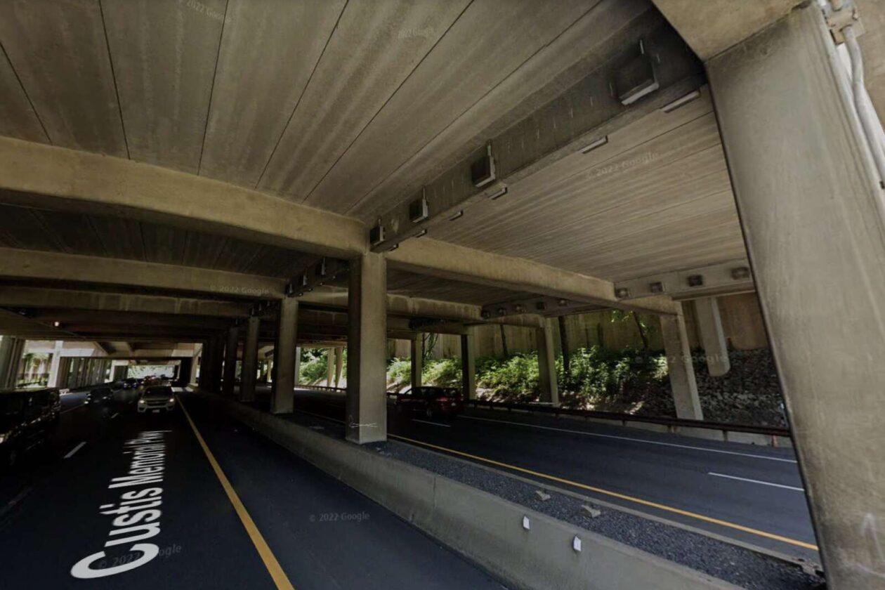
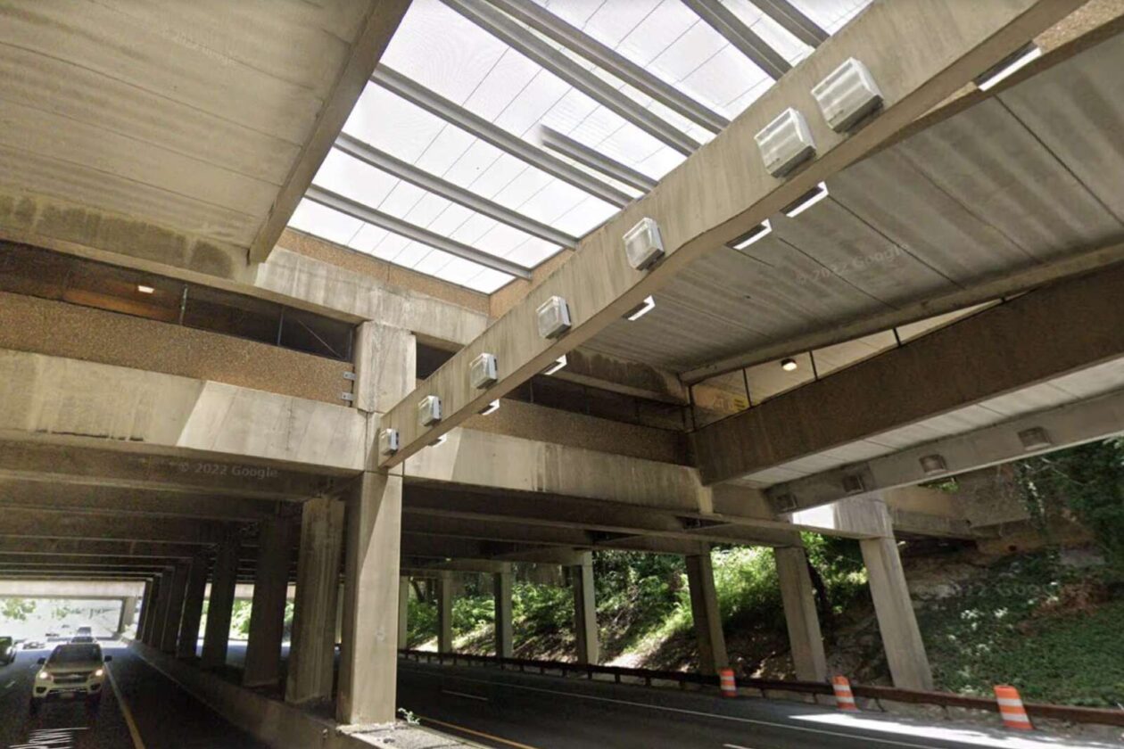
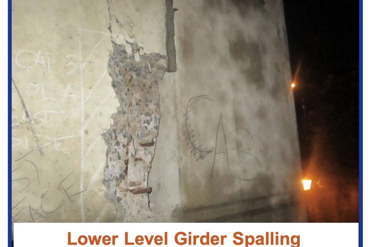
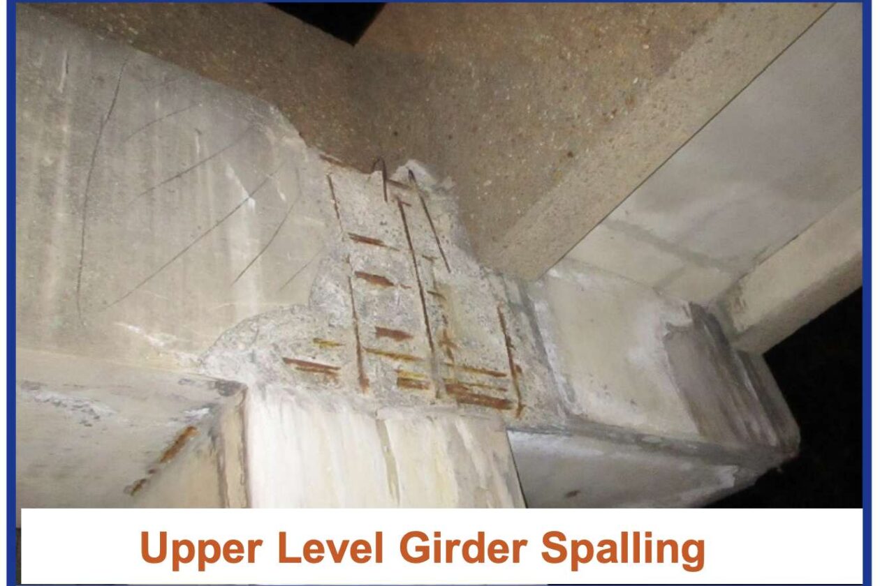
The parking garage over I-66 near Ballston is falling apart and needs repairs, says the Virginia Department of Transportation.
The garage sits above I-66 between N. Stafford and Quincy streets, next to Washington-Liberty High School. It serves as the primary parking area for the school and is the site of a seasonal flea market, called the Arlington Civitan Open Air Market.
VDOT has launched a public engagement period to brief locals on the garage’s deteriorating condition and the $2.7 million in planned improvements. Through next Monday, Nov. 7, people can provide comments online in a survey and by email or postal mail.
The Commonwealth seeks public input on repairing and rehabilitating the parking garage over I-66 at Washington-Liberty HS. And yes, galvanic cathodic protection is on the menu. https://t.co/dZQmSIbbWl pic.twitter.com/ZSWuwTpuN7
— Arlington Department of Environmental Services (@ArlingtonDES) October 28, 2022
The state transportation department says it aims to minimize traffic disruptions and keep most parking spaces available during construction. VDOT expects to send out the project for bid next summer and to start work in the fall of 2023, with construction wrapping up in about six months.
“The purpose of this project is to address various conditions identified through routine inspections that are likely to deteriorate further if not repaired soon,” a VDOT staff member said in a presentation. “Delaying action could allow some of them to become critical requiring much more extensive, expensive and disruptive repairs down the road. The repairs will ensure the structure remains safe for all users for years to come.”
The garage was built in 1982, and since then, there has been no major work performed beyond routine maintenance, VDOT Communications Coordinator Mike Murphy tells ARLnow.
After 40 years of exposure to the elements — including cycles of freezing and thawing, anti-icing salts, and high temperatures — the garage’s columns and surfaces are worse for wear, according to the state transportation department’s presentation. The presenter said these signs of deterioration are typical of structures this age.

Some columns on the garage’s lower level need significant repairs to ensure its structural integrity, the presenter said. Leaking water has caused the reinforcing steel within the concrete to corrode, causing the concrete to break in flakes.

In one phase of the project, traffic lanes on I-66 will be shifted to the outside lane and the shoulder to allow work along the median, per the presentation. Lane closures are expected to be limited to single lanes.
“The majority of repair work occurs on the lower level along I-66, which is isolated from parking areas of the garage,” the VDOT staff member said. “There will be no changes to local traffic patterns or pedestrian flow on N. Quincy Street, N. Stafford Street, or 15th Street N.”
No impacts to the Custis Trail — which runs parallel to I-66 under the garage — are anticipated at this time, Murphy said.
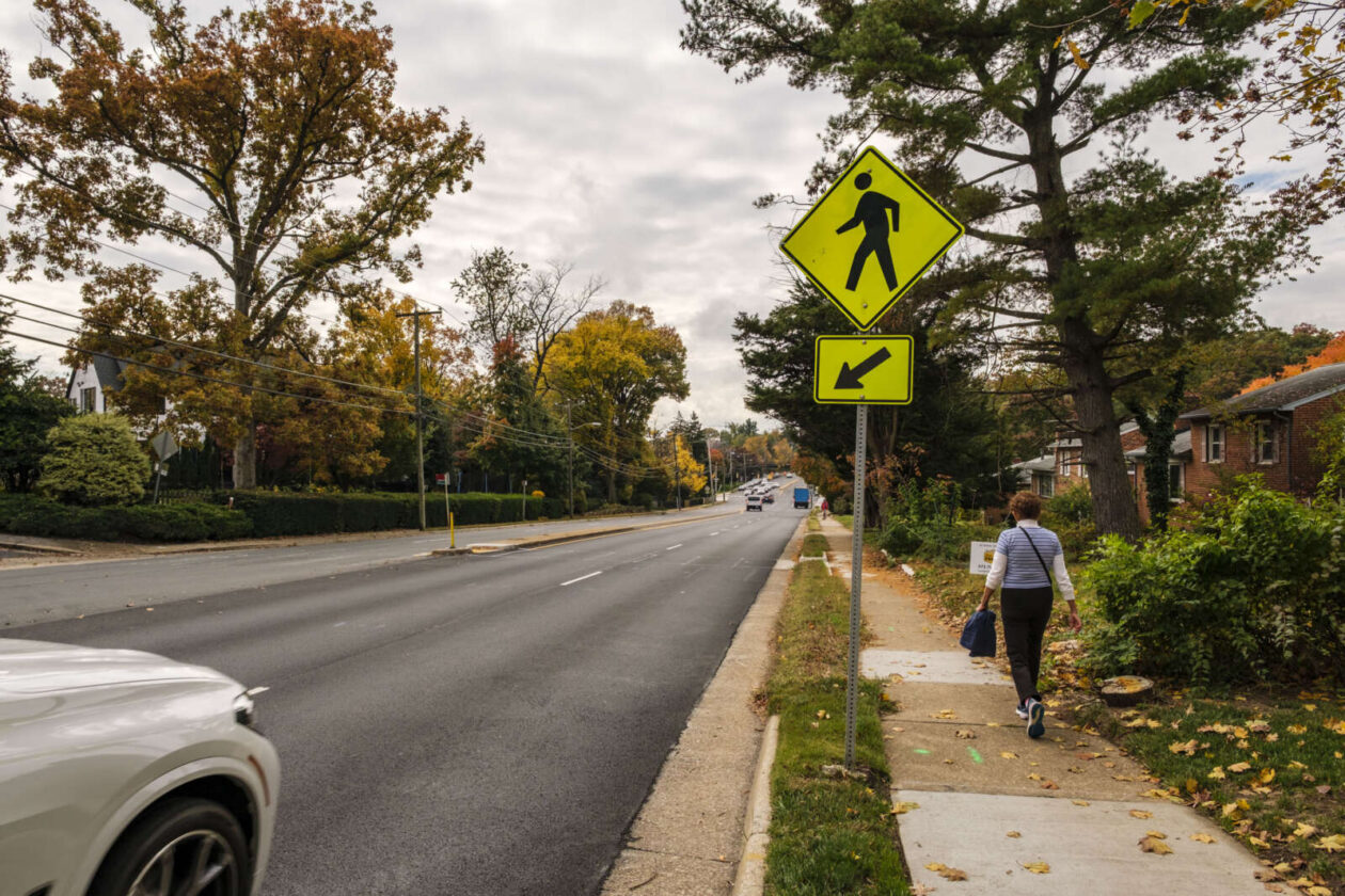
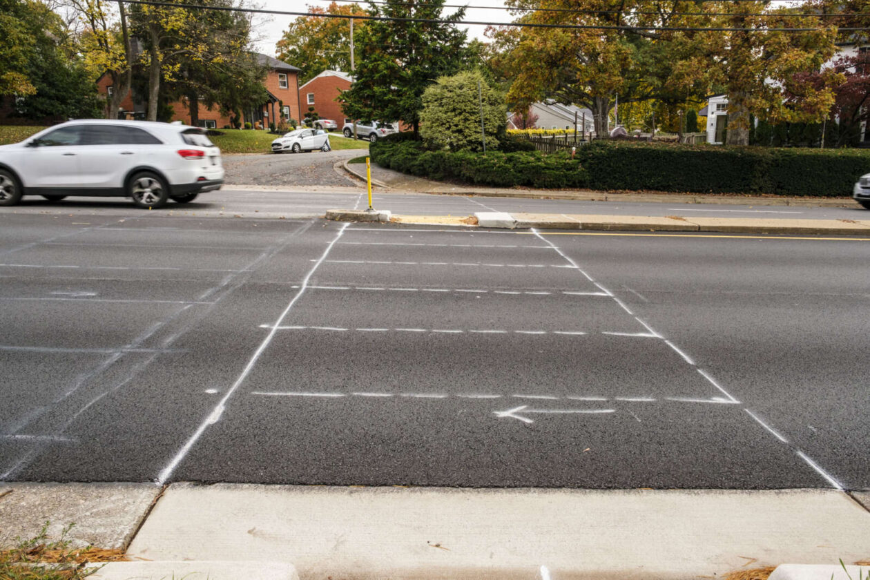
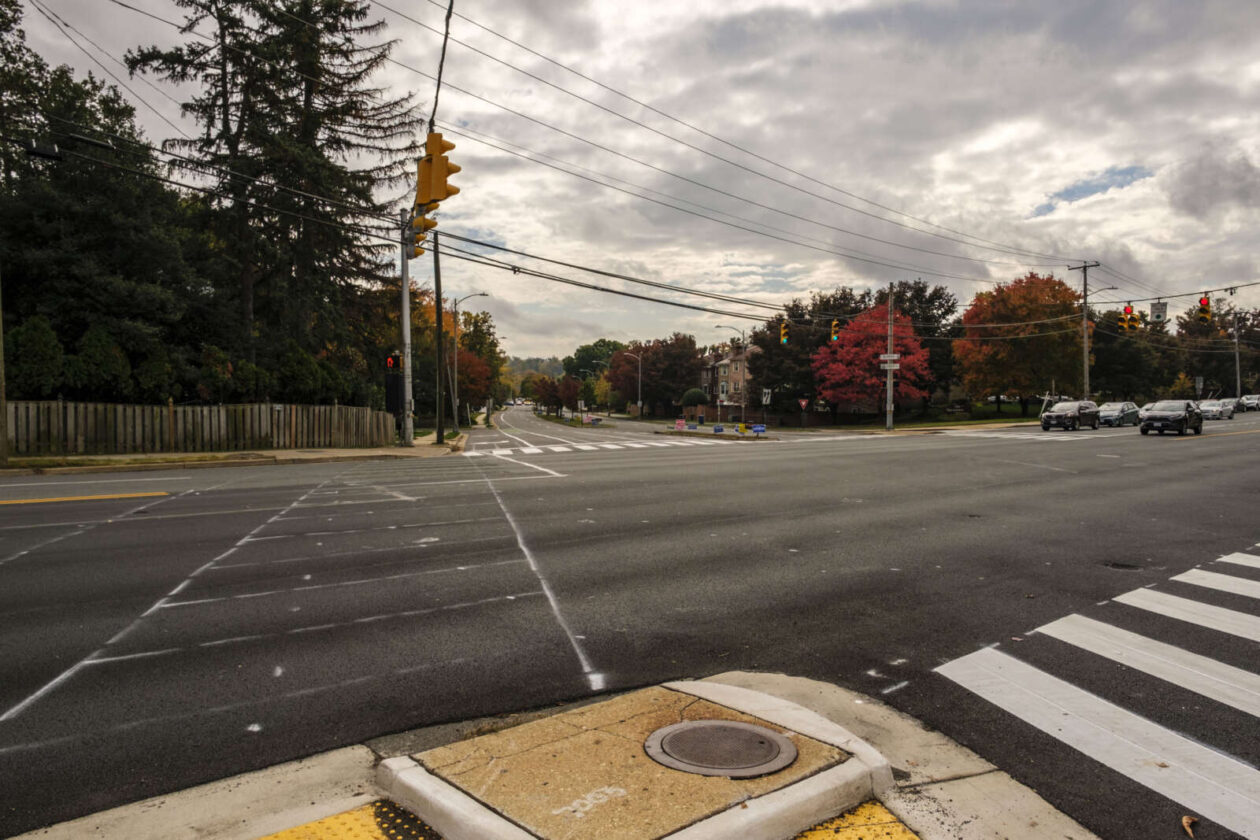
Unmarked or temporarily marked crosswalks along Langston Blvd are slated to be painted today (Friday), weather permitting.
The repainting activity comes nearly two months after the Virginia Department of Transportation paved Langston Blvd from Washington Blvd to N. Glebe Road, in East Falls Church, and from Military Road to N. Kenmore Street, in Cherrydale, according to a paving map.
VDOT, which manages the road, finished the repaving projects at the start of September, as part of its annual road repaving and repainting schedule.
According to the state transportation department, the lag between paving and painting is not uncommon.
“As the line painting contractors are different than the milling/paving contractors, sometimes schedules don’t line up as smoothly,” VDOT spokeswoman Ellen Kamilakis tells ARLnow.
Arlington County and some residents tell ARLnow they have raised concerns about the lag with state transportation department.
“VDOT is aware of our concerns and are working to complete the markings on Langston Blvd,” Arlington Dept. of Environmental Services spokeswoman Katie O’Brien said.
The repainting comes while pedestrian safety occupies the minds of Arlington County Board members, local advocates and residents. In recent months, drivers struck and killed two pedestrians: one woman near Thomas Jefferson Middle School was killed by an alleged drunk driver and a woman near Nottingham Elementary School was killed in a crash, which police are still investigating.
While VDOT repaves state routes, Arlington County does take advantage of the state’s schedule to consider changes to the streets under its purview through its Resurfacing for Complete Streets program, O’Brien said.
“For roadways maintained by VDOT, Arlington does coordinate with VDOT on improvements,” she said. “For example, this year VDOT will be adding crossing enhancements on Langston Blvd at our request.”
These include high visibility crosswalk markings, advance yield signs and markings, she says.
She added that the county coordinated with the state to “upgrade the two uncontrolled crosswalks at the intersections of Langston Blvd and N. Oakland Street and Langston Blvd and N. Nelson Street, as well as marking all side streets with high-visibility crosswalks instead of standard crosswalks.”
On Langston Blvd between Military Road and N. Kenmore Street, VDOT will be installing bike lane skip marks through intersections, high-visibility crosswalks along side streets and additional directional markings, according to the county’s first annual Vision Zero report, released this spring.
Arlington County is a year and a half into its Vision Zero initiative that aims to eliminate traffic fatalities and serious injuries. Between January 2021 and March 2022, the county updated 238 crosswalks to high-visibility crosswalks, according to the report.
It also “added new warning signage, pavement yield and high visibility crosswalk markings, and other minor improvements at 12 multilane crossing locations,” after a review of multi-lane crossings, per an August newsletter.

While Fairfax County mulls installing speed cameras, it may be some time before locals see speed cameras go up in Arlington.
In January, the Arlington County Board approved their installation in school and work areas to reduce speed-related crashes in these areas. The move is part of its Vision Zero campaign to eliminate traffic fatalities and injuries.
The Board made its move after the Virginia legislature allowed municipalities to install them in these locations in 2020.
But the Arlington County Police Department is still working on finding a vendor to implement the cameras, says Dept. of Environmental Services spokeswoman Katie O’Brien.
“ACPD is in the process of launching a procurement for a vendor, which is estimated to wrap up in spring 2023,” she tells ARLnow.
Once a vendor is chosen, the pace toward implementation could speed up. O’Brien says the county will have a better idea of where the cameras will go and when they’ll be installed “once vendor procurement is complete.”
The same is true for community updates.
“We will begin further community outreach and education once we are closer to procuring a vendor and beginning implementation, which will likely be in spring 2023,” she said.
Camera locations have not yet been chosen, said O’Brien. But Arlington schools have been close to a number of notable crashes, including a fatal crash involving a motorcyclist in front of Drew Elementary School, a fatal crash involving a pedestrian and a driver near Nottingham Elementary School, a fatal pedestrian crash near Thomas Jefferson Middle School, and a less serious crash involving a cyclist near Kenmore Middle School.
Locations will be chosen based on guidelines that DES has worked on with a consultant. That effort, funded by a Metropolitan Washington Council of Governments grant, is wrapping up, O’Brien said.
“The County (ACPD, APS, and DES) will then collaborate to refine and finalize specifications and guidelines, using the information from the grant project combined with local needs and knowledge,” she said.
Future progress, such as approving the vendor or camera locations, won’t need County Board approval, O’Brien said.
Once installed, cameras will identify and ticket speeding vehicles using radar, and police officers review footage to confirm the speeding violations. Tickets will be issued by mail to drivers traveling at least 10 mph over the speed limit, per state law.
The tickets will cost $50 and won’t result in a points reduction on your driver’s license or impact insurance rates.
“Speed camera fines are intended to encourage people to drive the speed limit,” the county says. “Fines do not generate revenue for police or transportation programs. Rather, fines issued will be distributed to the County’s General Fund. Therefore, there is no incentive to use speed cameras to fund department budgets.”
Community engagement is not set to begin until spring 2023. Previous outreach conducted as part of Arlington’s Vision Zero initiative, which reached more than 1,000 community members, indicated support for the cameras, according to the county.
Likewise, some supported speed cameras during online forums facilitated by Arlington’s Police Practices Work Group, as a way to reduce race- and ethnicity-based disparities in traffic enforcement.

After a driver collided with a child on a bicycle on S. Carlin Springs Road this week, neighbors and advocates are calling for street safety upgrades.
For its part, Arlington County says it has already been working on safety measures for the area, which has narrow sidewalks, little or no pedestrian buffer and a history of crashes. Upcoming steps include reducing speeds near the schools in the area: Kenmore Middle School and Carlin Springs Elementary.
“We are looking into the details from police regarding the crash and will identify next steps based on the report,” Dept. of Environmental Services spokeswoman Katie O’Brien said.
And Arlington County Board member Matt de Ferranti has recently gotten involved, too. He tells ARLnow he has walked the area with advocates and will be meeting with staff next week.
“First and foremost, I understand that the young man is okay and the safety of our kids and our residents is highest on my mind,” de Ferranti said. “Second, the accident raises important and urgent questions about safety in that whole corridor… We need to do better to address them.”
How the crash happened
Just before 7 p.m. on Monday, a driver traveling south on S. Carlin Springs Road proceeded through a green light and struck a juvenile riding a bicycle in the crosswalk, Arlington County Police Department spokeswoman Ashley Savage said.
The driver remained on scene. The child, who did not require a trip to the hospital for treatment, was tended to on scene by medics, Savage said. No citations were issued.
While ACPD does not provide identifying information, she did say the child involved was older than first reported on social media.
The boy was bleeding, but injuries appeared NLT. He was tended to by medics and police in the back of what appeared to be an @APSVirginia white van (logo on pass door – assuming Kenmore M.S. related) to in the 7-11 parking lot. pic.twitter.com/qtr4Yijzrn
— Matthew Young (@matthewyoung31) October 3, 2022
A history of unsafe sidewalks
Community advocate Janeth Valenzuela tells ARLnow that she passed by the crash around 6:45 p.m. and saw emergency responders. She says she’s been working on safety along S. Carlin Springs Road for many years now, and has suggested everything from building a bridge for kids crossing the road to erecting a fence to prevent kids from getting pushed into the street.
“I’ve been proposing a lot of things, but they don’t take it into consideration,” she said. “The solution is hard.”
S. Carlin Springs Road is an important walking route for Kenmore students, but she and other residents say the pedestrian amenities are poor. Sidewalks are narrow and not well maintained and often do not have any landscaping separating pedestrians from traffic.

And people have been telling the county the same thing for nearly a decade, according to a 2014 report by the APS Multimodal Transportation and Student Safety Committee and Advisory Committee on Transportation Choices meeting minutes from 2017.
During one ACTC meeting in 2017, a father said moms with strollers pass kids playfully shoving each other on the sidewalk as cars whiz right next to them. In the winter, if the sidewalks aren’t plowed, kids walk in the road, he added.

(Updated 6:00 p.m.) A new survey shows that a majority of Arlingtonians are satisfied with public transit, but their levels of satisfaction vary by geography.
Mobility Lab, a division of Arlington County Commuter Services, surveyed county residents last year to gauge travel patterns for work and non-work trips as well as concerns about public transit. This “state of the commute” survey was last conducted in 2010 and 2016, and the 2021 results included additional information about the pandemic’s effect on travel in Arlington.
ACCS uses the data to improve how it markets bicycling, walking and transit options to residents, businesses, and commercial and residential property managers, said Dept. of Environmental Services spokeswoman Claudia Pors. Those people-facing efforts include Bike Arlington, Walk Arlington and Arlington Transportation Partners.
“The primary uses of ACCS surveys are to check how well these programs are running,” she told ARLnow.
Of the 4,213 respondents, 71% of residents said they were satisfied with transit in Arlington. But people living along Metro corridors were happier with their options than people living in parts of South Arlington where the bus is the main transit mode.
People living along the Rosslyn-Ballston and Route 1 corridors were the most satisfied with their options, at 81% and 75%, respectively. And they were more likely to be members of Capital Bikeshare, at 37% and 38%, respectively.
Outside of the Metrorail corridor, the survey found satisfaction levels of 64% in Shirlington, 58% in Columbia Pike and 64% in what was deemed “Other South.” Shirlington residents reported lower rates of availability for various transportation services in general and only 13% said they had a Bikeshare membership.
Pors said a takeaway from the survey for ACCS might be that they need to focus their outreach in Shirlington “to make sure they’re aware of their options… and make sure apartment managers are talking to tenants, and using daily face time to make sure they’re fully informed.”
What the data will not do, Pors said, is set which transit projects to prioritize — for instance, applying more time and staff to improving bus transit along the Pike over adding a second entrance to the Ballston Metro station.
Concerns about safety and long waits
While generally happy with their options, Arlingtonians did have some gripes with the transit system, including how long one must wait for the bus or Metrorail as opposed to driving.
Nearly 40% said they would have to wait too long for transit to arrive while another 35% said the trip would take too long.
As for barriers to bicycling, two-thirds of residents said they don’t feel safe riding a bike in traffic, while another 37% mentioned concerns about the network of bike paths or bike lanes.
The pandemic spurs changes
The survey showed how transit use for non-work trips changed during the pandemic. While remote work contributed to the widely reported steep drop in Metro ridership, between 2015 and 2021, transit use for non-work trips also declined from 87% to 68%.
But one form of transportation increased during the pandemic: walking. About 34% reported walking “somewhat more” for non-work trips and 22% walking “much more.”
In fact, many respondents said the most important transportation needs facing the county post-pandemic are ones that take them outside: walking (58%) and cycling and scooting (42%).
Meanwhile, most respondents said they won’t be changing their commuting mode anytime soon: 81% who drove alone, 82% who used transit, and 71% who biked or walked indicated they would keep doing so post-pandemic.
Still, to chip away at those statistics, Arlington is embarking on extensive marketing efforts to encourage people to swipe their SmarTrip cards and stop driving.
“Through ACCS, [the county is] going to come out with more messaging to get people to feel comfortable on transit again,” Pors said. “There has been that loyal set of riders who’ve stayed through the pandemic. Maybe this is an opportunity for people who shifted to single-occupancy vehicles to try something new, and pitching bus as that option.”
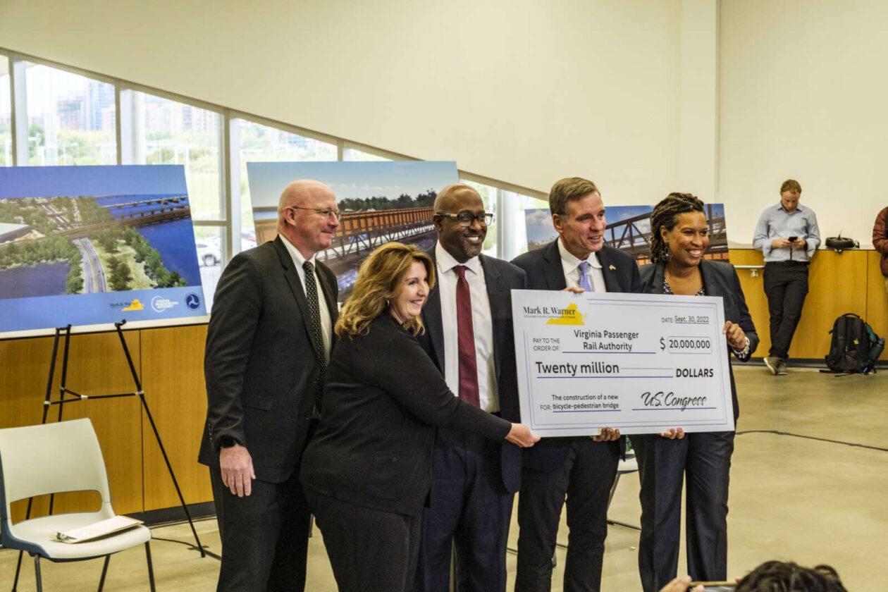
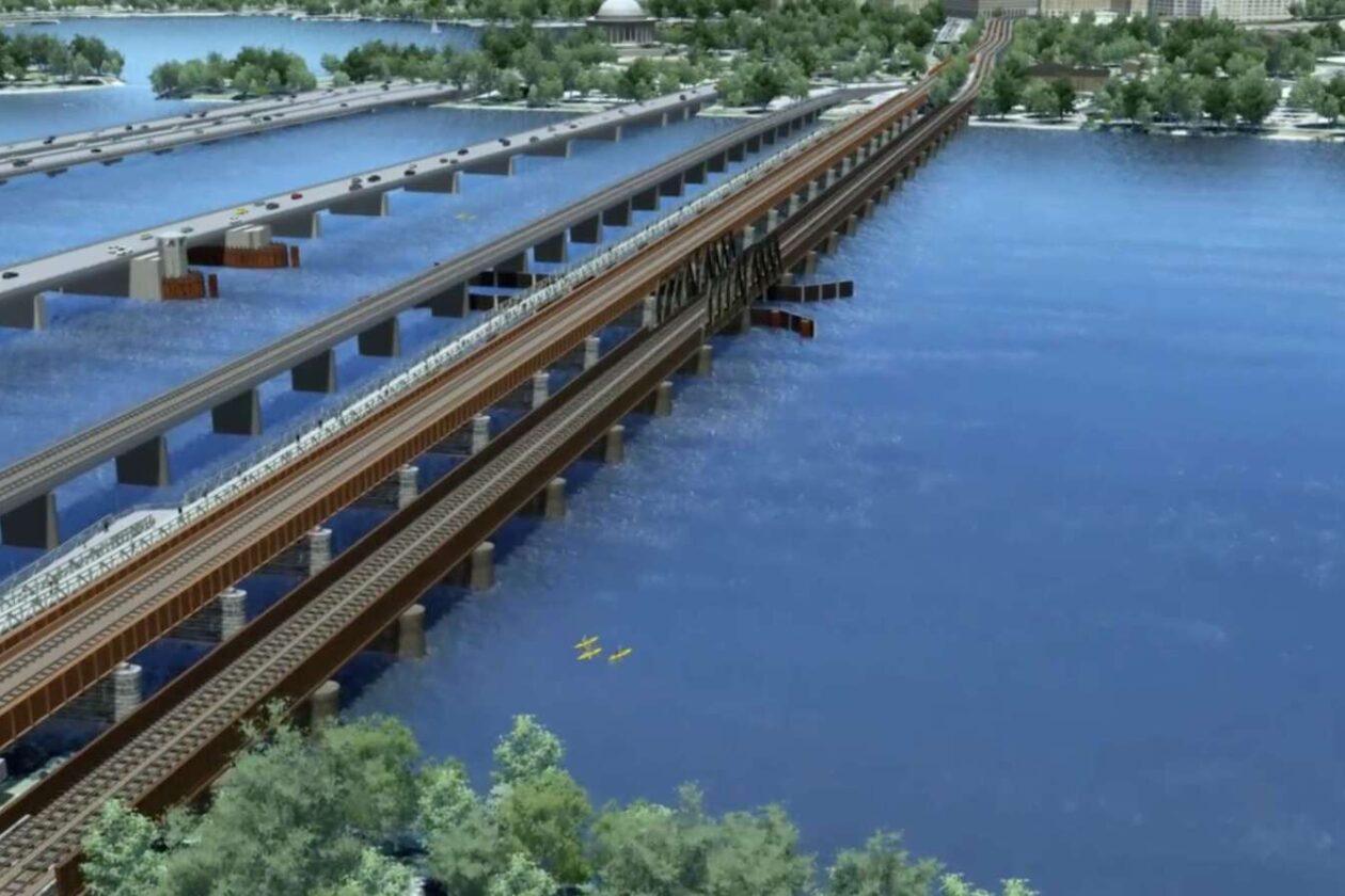
A proposed bridge for bicyclists and pedestrians between Crystal City and the Southwest Waterfront area of D.C. has received $20 million in federal funding to move forward.
When complete, the 16-foot-wide shared-use path will connect Long Bridge Park and East and West Potomac parks via the Mount Vernon Trail.
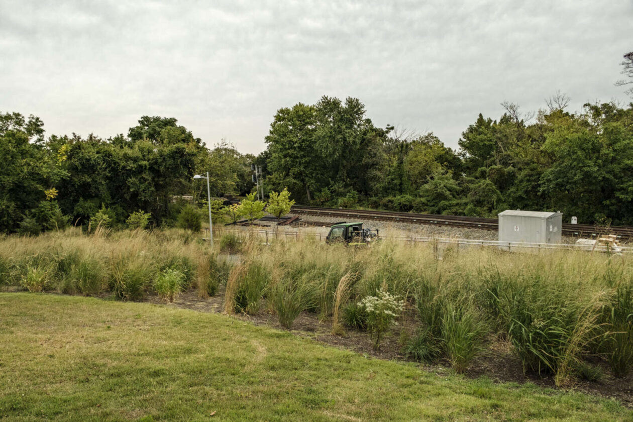
On the Virginia side, the bridge will be located behind the Long Bridge Park Aquatics & Fitness Center (333 Long Bridge Drive), which opened last year. It will eventually provide a connection to the expanded and relocated Virginia Railway Express (VRE) station set to open in 2024.
Several local elected officials, including D.C. Mayor Muriel Bowser, Arlington County Board Vice-Chair Christian Dorsey and Alexandria Vice-Mayor Amy Jackson, gathered this morning (Friday) at the aquatics center to hold an oversized $20 million check and celebrate the project, which could be completed by 2030.
“This is going to be a major gateway for Arlington that allows residents and visitors who walk, bike or roll to come to this beautiful facility and the environs around Long Bridge Park, but then be able to move on to Crystal City and National Landing and points beyond via the Mount Vernon Trail and the robust bicycle infrastructure that we are developing that will go all the way through to the City of Alexandria,” Dorsey said. “This helps meet Arlington and our region’s goals of moving more people with less automobile traffic. ”
U.S. Sen. Mark Warner (D-Va.) secured the funding from the Rebuilding American Infrastructure with Sustainability and Equity (RAISE) program, which was included in the Infrastructure Investment and Jobs Act, which Warner co-wrote.
“I am thrilled to announce this new funding for the Long Bridge Pedestrian Crossing project. This $20 million investment was made possible by the bipartisan infrastructure law I was proud to help write and will help the Virginia Passenger Rail Authority (VRPA) complete a new span across the Potomac dedicated to cyclists and pedestrians,” Warner said in a statement. “This project is a key component of the broader effort to fix a major rail chokepoint and expand commuter and passenger service over the Potomac River.”
The shared-use bridge serves as environmental mitigation for the Long Bridge Project to add a two-track rail bridge next to the existing two-track 117-year-old Long Bridge, owned by the freight railroad company CSX Transportation. Once completed, the expanded railway is projected to bring an annual $6 billion in benefits to the region by 2040, according to a press release.
“We would never even be in the running [for funding for this project] if it weren’t for the infrastructure bill,” Warner told reporters after the event. “That’s got $58 billion additional dollars for passenger rail. We intend to make sure the District and Virginia get its share and it’s our hope the passenger rail bridge would open before the end of the decade.”
The goal of the $2 billion Long Bridge Project, discussions for which began in 2010, is to alleviate rail congestion on the existing Long Bridge. Annually, up to 1.3 million Amtrak passengers and 4.5 million VRE commuters traverse the bridge, in addition to CSX freight trains, according to a project website.
Officials say that the aging bridge is heavily utilized and frequently experiences bottlenecks, and — as if to prove their point — a freight train and an Amtrak train sped by within five minutes of each other during the media event.
Meanwhile, pedestrians and cyclists looking to cross the Potomac at this point have to navigate crossings shared with vehicles and maneuver a 10-foot-wide shared-use path on the 14th Street Bridge.
The lead agency on the project will be the VPRA, which the Virginia General Assembly created in 2020 to “promote, sustain and expand the availability of passenger and commuter rail service in the Commonwealth,” said VPRA Executive Director DJ Stadtler.
While elected officials heralded the new pathway over the Potomac, pedestrians and bicyclists in attendance told ARLnow that the 16-foot bridge is still too narrow to accommodate cyclists and pedestrians alike.
Stadtler told ARLnow that VPRA’s initial 10% complete designs proposed a 14-foot bridge, but in response to feedback, is widening it to 16 feet for the 30% complete designs. The agency has “considered all options” and has determined the current proposal is an appropriate width, he added.
There will be opportunities for the public to weigh in next spring.
During the event, Dorsey joked about the bridge width.
“What did you say, a 20-foot bridge?” he said, to cheers from cyclists in attendance.
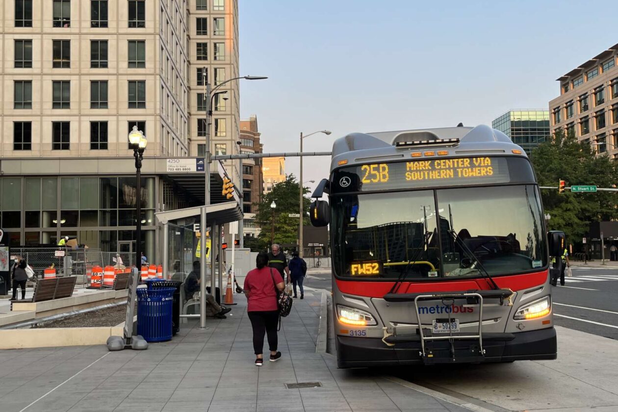
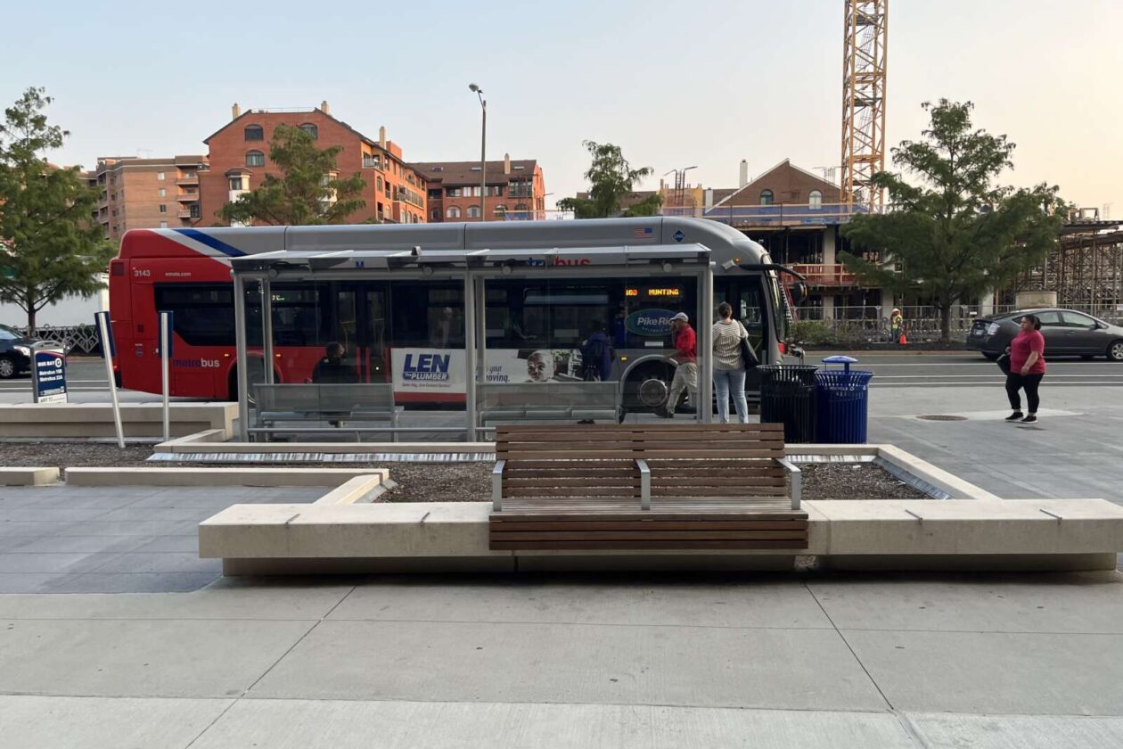
An end date is in sight for construction work around the Ballston Metro station.
After two years of navigating the active work site and catching the bus from temporarily relocated stops, transit riders could have access to the updated transit facilities and adjacent public areas sometime next month.
“Right now we have our sights on completion in late October,” said Dept. of Environmental Services spokeswoman Claudia Pors.
Over the course of four phases, Arlington County aimed to improve the experience of waiting for a bus, getting dropped off by a car, and walking and cycling around the transit hub. The project added:
- New bus shelters, sidewalks, landscaped planters and benches
- More bike parking
- An expanded public space along Fairfax Drive
- A dedicated “kiss-and-ride” curb space
- A dedicated shuttle bus curb space and bus shelter
- Bus stop flag poles
- Real-time bus information displays
Construction on the four-phase project started in June 2020 and was expected to end in November 2021. But a half dozen “unforeseen conditions” came up during construction, delaying completion by nearly a year, according to a county report.
Before it can sign off on the project, the county says the following three intersections need to be repaved “due to design changes and unforeseen utility work,” per the report.
- Fairfax Drive and N. Stuart Street
- Fairfax Drive and N. Stafford Street
- 9th Street N. and N. Stuart Street
This will cost about $249,000, bringing the total cost of the project to around $5.7 million. The Arlington County Board is set to review a request to authorize this additional spending during its meeting on Saturday.
Contingency funding approved in the initial budget covered the cost of the other surprises. Staff said electric and telecom lines along Fairfax Drive had to be relocated and it took longer than expected to get Dominion Energy to remove existing street light poles.
The underground Metro platform and garages were also closer to the surface than staff initially estimated. To avoid hitting these structures, construction plans had to be updated and one planter had to be redesigned.
Other planters had to be remade because of how the site slopes, while additional pre-made planters had to be purchased because original estimates fell short.
A curb along N. Stafford Street needed to be realigned and a bus landing rebuilt to ensure getting on and off the bus was safe and accessible to people with disabilities.
Pors said county staff are looking forward to wrapping up.
“Obviously, we’re very excited for the completion of this project,” Pors said.
The Washington Metropolitan Area Transit Authority (WMATA) has also finalized where buses will depart from. The listed changes are set to go into effect this Sunday, Sept. 18:
1A to Vienna: Bay F
1B to Dunn Loring: Bay F
2A to Dunn Loring: Bay C
10B to Hunting Point: Bay G
22A to Pentagon: Bay G
23A, 23B, 23T to Shirlington/Crystal City: Bay H
23A, 23T to Tysons: Bay A
25B to Southern Towers/Mark Center: Bay D
38B to Farragut Square: Bay B
Meanwhile, the county is currently working to design proposed west entrance to the Ballston Metro station, located at N. Fairfax Drive and N. Vermont Street, almost a quarter of a mile west of the existing entrance.
Arlington has sought alternative funding sources to cover the ballooning cost of the project, which it attributes to inflation and having more complete designs.
Some transit advocates have argued that funding for the section entrance should be redirected to cheaper upgrades with greater impact, such as sidewalks, protected bike lanes and dedicated bus lanes.