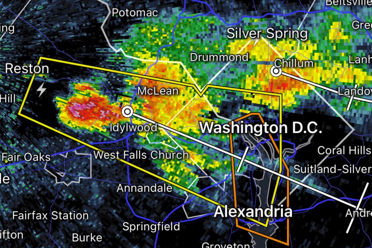
Update at 3:40 p.m. — The severe storm for which forecasters issued a warning dropped sizable hail over a large swath of Arlington, from Pentagon City to Ballston to northern residential neighborhoods. While the warning is expiring, the earlier Severe Thunderstorm Watch (below) remains in effect.
More from social media:
@capitalweather I’ll pass on the dog walk for now. @ARLnowDOTcom pic.twitter.com/JSRAkGVaVN
— David (@Dhartogs) April 15, 2024
Lots of hail in Arlington! @capitalweather @ARLnowDOTcom pic.twitter.com/JEdnKCoyhX
— Jen kennedy (@Jenkennedy5) April 15, 2024
— Kenneth Deuel (@KenDeuel) April 15, 2024
@capitalweather Sound up — heavy hail in Pentagon City. pic.twitter.com/m7RkM8sUK5
— Rebecca 🇺🇦 (@rdc20132) April 15, 2024
Update at 3 p.m. — A Severe Thunderstorm Warning was just issued for Arlington County as a strong storm packing hail approaches.
From the National Weather Service:
BULLETIN – IMMEDIATE BROADCAST REQUESTED
Severe Thunderstorm Warning
National Weather Service Baltimore MD/Washington DC
259 PM EDT Mon Apr 15 2024The National Weather Service in Sterling Virginia has issued a
* Severe Thunderstorm Warning for… The southwestern District of Columbia… Arlington County in northern Virginia… The City of Falls Church in northern Virginia… Northeastern Fairfax County in northern Virginia… The City of Alexandria in northern Virginia…
* Until 345 PM EDT.
* At 258 PM EDT, a severe thunderstorm was located over Reston, moving east at 30 mph.
HAZARD…Quarter size hail.
SOURCE…Trained weather spotters.
IMPACT…Some hail damage to agriculture is expected.
* Locations impacted include… Arlington, Alexandria, Reston, Annandale, Vienna, Falls Church, Pimmit Hills, Reagan National Airport, Mclean, Rosslyn, Crystal City, Howard University, Oakton, Lincolnia, Tysons Corner, Wolf Trap, Merrifield, Lake Barcroft, American University, and I66 and I495 Interchange.
PRECAUTIONARY/PREPAREDNESS ACTIONS…
For your protection move to an interior room on the lowest floor of a building.
Severe Thunderstorm Warning including Washington DC, Arlington VA and Alexandria VA until 3:45 PM EDT pic.twitter.com/LzVkWjfWv0
— NWS Baltimore-Washington (@NWS_BaltWash) April 15, 2024
Hail leading to drivers huddling under overpasses in parts of Fairfax County. Live traffic and weather updates at 103.5 FM and https://t.co/sC34YtkfC6 on the 8s. #dcwx #dctraffic pic.twitter.com/qInPQBn0QD
— WTOP Traffic (@WTOPtraffic) April 15, 2024
Earlier: A Severe Thunderstorm Watch has just been issued, as some strong storms approach Arlington from the northwest.
Arlington, the District and other neighboring counties — as well as points west, south and east — are all covered by the watch, which is in effect until 10 p.m.
The National Weather Service says large hail, frequent lightning, and scattered wind gusts up to 70 mph are possible with the storms that are developing.
The earliest arriving storms can currently be seen on radar, over Loudoun and Montgomery counties.
More, below, from NWS via social media.
A severe thunderstorm watch has been issued for parts of Maryland, Virginia and West Virginia, and the District of Columbia, until 10 PM EDT. Large hail and damaging winds are the main threats. pic.twitter.com/Yr3innCAGN
— NWS Baltimore-Washington (@NWS_BaltWash) April 15, 2024
Scattered severe thunderstorms likely along/south of I-66/US-50 this afternoon. Large hail & damaging wind will be the main threats, along with lightning strikes. The strongest storms are most likely around the Fredericksburg to far Southern MD area. #MDwx #VAwx #WVwx #DCwx pic.twitter.com/qX3aQ3o1xl
— NWS Baltimore-Washington (@NWS_BaltWash) April 15, 2024
")
Enjoy the sunny weather while you can — a very wet start to the weekend is on tap.
The National Weather Service just issued a Flood Watch for Arlington County and other parts of the D.C. area. It’s in effect from late Friday, when the rain is expected to start, through Saturday afternoon.
Up to 2.5 inches of rain could fall, forecasters say. Windy conditions are expected after the rainstorm, which could lead to power outages.
More, below, from NWS.
210 PM EDT Thu Mar 21 2024
…FLOOD WATCH IN EFFECT FROM LATE FRIDAY NIGHT THROUGH SATURDAY AFTERNOON…
* WHAT…Flooding caused by excessive rainfall is possible.
* WHERE…The District of Columbia, portions of Maryland, including the following areas, Anne Arundel, Cecil, Central and Southeast Howard, Central and Southeast Montgomery, Prince Georges, Southeast Harford, and Southern Baltimore, and portions of northern Virginia, including the following areas, Arlington/Falls Church/Alexandria, and Fairfax.
* WHEN…From late Friday night through Saturday afternoon.
* IMPACTS…Excessive runoff may result in flooding of rivers, creeks, streams, and other low-lying and flood-prone locations. Flooding may occur in poor drainage and urban areas. Low-water crossings may be flooded.
* ADDITIONAL DETAILS…
– Rainfall of 1.5 to 2.5 inches is most likely late Friday night through Saturday morning, with rain expected to depart Saturday afternoon. The bulk of this rain is expected to fall in a six period, and may result in flooding of urban and poor drainage areas, as well as on small streams.
– Please visit www.weather.gov/safety/flood for flood safety and preparedness information.PRECAUTIONARY/PREPAREDNESS ACTIONS…
You should monitor later forecasts and be alert for possible Flood Warnings. Those living in areas prone to flooding should be prepared to take action should flooding develop.
")
Update at 8:45 p.m. on 3/20/24: Due to the smoke, air quality in Arlington has reached moderately unhealthy levels, according to AirNow.gov.
Update at 5:30 p.m. on 3/20/24: A smoky haze has settled over Arlington amid multiple brush fires in parts of Northern Virginia and West Virginia. Small outdoor fires — mostly mulch fires — have also been reported in Arlington.
Multiple fires have erupted in western Virginia, fanned by high winds. You can smell the smoke in the air in the DC area.
See the hot spots in this satellite image.
Read more in our pm update ⬇️https://t.co/bJe1L1Sh2F pic.twitter.com/HrMkkdPUrp
— Capital Weather Gang (@capitalweather) March 20, 2024
5:34pm: There are numerous wildfires in the Shenandoah Valley and surrounding areas. If you are smelling smoke outdoors, those fires are the likely source.
— NWS Baltimore-Washington (@NWS_BaltWash) March 20, 2024
Update at 2 p.m. on 3/20/24: The earlier Fire Weather Watch for Arlington and the region has been upgraded to a Red Flag Warning.
It’s in effect until 8 p.m. Wednesday. More, below, from the National Weather Service.
URGENT – FIRE WEATHER MESSAGE
National Weather Service Baltimore MD/Washington DC
155 PM EDT Wed Mar 20 2024…RED FLAG WARNING IN EFFECT UNTIL 8 PM EDT THIS EVENING FOR GUSTY WINDS AND LOW RELATIVE HUMIDITY IN THE WASHINGTON AND BALTIMORE METROPOLITAN AREAS AS WELL AS PORTIONS OF NORTHERN VIRGINIA AND CENTRAL MARYLAND.
The National Weather Service in Baltimore MD/Washington has issued a Red Flag Warning for gusty winds and low humidity, which is in effect until 8 PM EDT this evening.
* WINDS…West 20 to 25 mph with gusts around 45 mph.
* RELATIVE HUMIDITY…As low as 15 percent.
* IMPACTS…The combination of dry conditions, low humidity, and strong gusty winds may result in favorable conditions for the rapid spread of fires.
* FUEL MOISTURE…Less than 10 percent for 10 hour fuels.
PRECAUTIONARY/PREPAREDNESS ACTIONS…
A Red Flag Warning means that critical fire weather conditions are either occurring now, or will shortly. A combination of strong winds, low relative humidity, and warm temperatures can contribute to extreme fire behavior.
Earlier: There’s an elevated fire danger in Northern Virginia and other parts of the D.C. region today and tomorrow.
Dry, breezy conditions mean that brush fires can spread quickly. While the danger of large forest fires in Arlington is low, smaller brush fires do occur on occasion.
The National Weather Service issued a Special Weather Statement for the fire danger Tuesday and a Fire Weather Watch for the region on Wednesday.
")
It’s going to be a soggy Saturday night and Sunday morning.
The National Weather Service just issued a Flood Watch for Arlington and other parts of the D.C. area. It will go into effect at 1 a.m.
Forecasters say heavy rain overnight, combined with upstream snow melt, may cause localized flooding.
From NWS:
…A band of moderate to locally heavy rain will accompany a potent frontal system. This pushes across the affected area during the middle of this evening into Sunday morning…
…FLOOD WATCH IN EFFECT FROM 1 AM EST SUNDAY THROUGH SUNDAY MORNING…
* WHAT…Flooding caused by excessive rainfall is possible.
* WHERE…Portions of DC, including the following , District of Columbia, Maryland, including the following areas, Anne Arundel, Central and Southeast Howard, Central and Southeast Montgomery, Northwest Howard, Northwest Montgomery, Prince Georges and Southern Baltimore, and northern Virginia, including the following areas, Arlington/Falls Church/Alexandria, Eastern Loudoun, Fairfax and Western Loudoun.
* WHEN…From 1 AM EST Sunday through Sunday morning.
* IMPACTS…Excessive runoff may result in flooding of rivers, creeks, streams, and other low-lying and flood-prone locations.
* ADDITIONAL DETAILS…
– The combination of moderate to locally heavy rainfall coupled with increased upstream snow melt into the area watersheds. 6-hour rain totals could easily reach 1 inch in many spots. Expected storm totals range from 1.50 to 2.00 inches, particularly closer to I-95.
A Flood Watch has been issued for a large portion of our region along and east of the Blue Ridge Mountains from Nelson Co up to southern Baltimore Co. This Flood Watch is in effect for late this evening into Sun morning. Total amounts will range from 1.50-2.00". #MDwx #VAwx #DCwx pic.twitter.com/QLn1f0NiRR
— NWS Baltimore-Washington (@NWS_BaltWash) January 27, 2024
")
After an expected deluge tonight, Saturday may feature hazardous wind gusts.
The National Weather Service just issued the following Wind Advisory, warning of falling tree limbs and possible power outages to start the weekend.
…WIND ADVISORY REMAINS IN EFFECT FROM 7 AM TO 4 PM EST SATURDAY…
* WHAT…West to southwest winds 20 to 30 mph with gusts up to 50 mph expected.
* WHERE…Portions of central, north central, northeast, northern and western Maryland, The District of Columbia, northern and northwest Virginia and eastern and panhandle West Virginia.
* WHEN…From 7 AM to 4 PM EST Saturday.
* IMPACTS…Gusty winds could blow around unsecured objects. Tree limbs could be blown down and a few power outages may result.
In addition to the earlier Flood Watch, which takes effect at 6 p.m. tonight, Arlington is also under a Coastal Flood Advisory.
…COASTAL FLOOD ADVISORY REMAINS IN EFFECT FROM 5 AM TO NOON EST SATURDAY…
* WHAT…Up to one foot of inundation above ground level expected in low lying areas due to tidal flooding.
* WHERE…Shoreline in the City of Alexandria and Arlington County.
* WHEN…From 5 AM to noon EST Saturday, especially around the time of high tide.
* IMPACTS…Water is expected to approach the curb near the intersection of King Street and Strand Street in Alexandria.
* ADDITIONAL DETAILS…Tides two to two and a half feet above normal. The next high tides at Alexandria are at 8:59 PM this evening and 9:30 AM Saturday morning.
The active weather pattern is slated to continue into next week. Starting Sunday, arctic air will bring an extended bout of freezing temperatures to the area, ahead of a potential snowstorm on Tuesday.
Some forecasters are highlighting the potential of major snow accumulation, while others are more reserved in their predictions.
Hot of the Presses: The UKMET Model brings a major snowstorm Tuesday
Note: this snowfall map is based on a 10:1 ratio. This is probably much too low of a ratio based on the arctic cold availible to be tapped. If everything were to work out as the UKMET depicts, actual snowfall… pic.twitter.com/9oRwrKY8Jm— Mark Margavage (@MeteoMark) January 12, 2024
")
If Tuesday’s soaker of a storm left you wanting, an encore is on the way.
The National Weather Service has just issued a Flood Watch for Friday night, warning of heavy rain and the potential for localized flooding in the D.C. area.
The watch will take effect at 6 p.m. Friday and run through 6 a.m. Saturday.
More, below, from the National Weather Service.
…FLOOD WATCH IN EFFECT FROM FRIDAY EVENING THROUGH LATE FRIDAY NIGHT…
* WHAT…Flooding caused by excessive rainfall is possible. […]
* WHEN…From Friday evening through late Friday night.
* IMPACTS…Excessive runoff may result in flooding of rivers, creeks, streams, and other low-lying and flood-prone locations.
* ADDITIONAL DETAILS…
– A period of moderate to locally heavy rain is expected ahead of a cold front, beginning late Friday afternoon and continuing through Friday evening before ending overnight. Rainfall amounts around three quarters of an inch to an inch and a half are most likely with localized amounts around 2 inches possible. Most of the rain will fall in a three to six hour period Friday evening. The locally heavy rain combined with already saturated soil may cause excess runoff leading to flooding of streams and creeks as well as potential flooding in urban and low-lying areas.
A potent low pressure system will arrive Friday PM, bringing heavy rain and gusty winds. A Flood Watch is in effect for areas along/east of the Blue Ridge. Additionally, wind headlines are in effect for the Allegheny Front and along the waters Friday PM into the overnight hours. pic.twitter.com/U0RMnsqGHD
— NWS Baltimore-Washington (@NWS_BaltWash) January 11, 2024
")
Update at 3:55 p.m. — A Flood Warning has been issued for Arlington.
Update at 12:30 p.m. — The earlier Wind Advisory has been upgraded to a High Wind Warning.
…HIGH WIND WARNING IN EFFECT UNTIL 1 AM EST WEDNESDAY…
* WHAT…Southeast winds 25 to 40 mph with gusts up to 60 mph expected.
* WHERE…In District of Columbia, District of Columbia. In Maryland, Prince Georges, Charles, Central and Southeast Montgomery and Central and Southeast Howard Counties. In Virginia, Fairfax, Stafford, King George and Central and Southeast Prince William/Manassas/Manassas Park Counties, and Arlington/Falls Church/Alexandria.
* WHEN…Until 1 AM EST Wednesday.
* IMPACTS…Damaging winds will blow down trees and power lines. Widespread power outages are expected. Travel will be difficult, especially for high profile vehicles.
Damaging winds are expected later this afternoon & evening as a potent storm system crosses the region. Highest wind gusts in excess of 40-55 mph will occur between 5-10pm this evening. Locally higher gusts are possible over the ridges/waters. More wind Wed.. #MDwx #VAwx #WVwx pic.twitter.com/Wp5SiHwBS4
— NWS Baltimore-Washington (@NWS_BaltWash) January 9, 2024
Update at 12:25 p.m. — The National Weather Service has issued the following forecast update, predicting deteriorating conditions and a period of “intense” rainfall between 6-10 p.m.
…HAZARDOUS WEATHER CONDITIONS FOR BALTIMORE/WASHINGTON
REGION TODAY BETWEEN 500 PM AND 1000 PM EST…Weather conditions will deteriorate as a strong frontal system approaches this afternoon, then passes through the greater Baltimore/Washington region this evening. This will result high winds capable of downing trees and powerlines, tidal flooding, and the potential for flooding of small streams and creeks. This will create hazardous travel conditions late this afternoon through late evening across the region.
Light-to-moderate rain will continue early this afternoon, then increase in intensity late this afternoon, with a several hour period of heavy, intense rainfall expected between 6 PM and 10 PM. This heavy rainfall, coupled with already saturated soils from recent rainfall, will cause flooding of small streams and creeks. Do not attempt to drive across flooded roadways; additionally, flooding at night increases the risk for motorists not being able to quickly identify the water hazards due to decreased visibilities by the heavy rain and darkness.
Easterly winds will increase in intensity as well this afternoon across the region, with gusts to 50 MPH expected late this afternoon through mid-evening. Locations closer to the Chesapeake Bay will see higher wind gusts of 60-70 MPH. Strong winds will increase the risk of falling trees and downed powerlines. Again, the risk of poor outcomes resulting from high winds is increased during nighttime. Winds will decrease after midnight tonight.
Finally, areas along the tidal Potomac River and western shore of the Chesapeake Bay north of Smith Point VA should prepare for moderate-to-major tidal flooding. The cities of Baltimore, Annapolis MD, and Alexandria VA are most prone to tidal flooding, and the coupling of heavy rainfall and strong onshore winds of 50-60 MPH in these locations will work together to create moderate-to-major tidal impacts.
Earlier: Arlington County will be under a Wind Advisory and a Flood Watch from early this afternoon until Wednesday morning.
A storm packing heavy rain and gusty winds will sweep through the area, forecasters say, potentially causing widespread power outages.
Some local school districts like Montgomery County are dismissing students early, but Arlington and neighboring Alexandria and Fairfax County have so far not announced any early dismissals.
As of noon Arlington Public Schools said that after-school and evening activities have been canceled.
All APS after-school and evening activities are canceled for today, Tue, Jan. 9, 2024, including extracurricular activities, games, team practices, field trips, adult education classes, and programs in schools and on school grounds. The School Board Work Session scheduled for this evening is also canceled. Extended Day will remain open until 6 p.m. For updates about Pool Operations, go to www.apsva.us/aquatics. For information about Arlington County programs and operations, go to www.arlingtonva.us.
VDOT, meanwhile, is warning of a potentially hazardous evening on local roads. From a press release:
…heavy rain is forecast across the commonwealth from Tuesday afternoon through Tuesday night, with precipitation pushing off to the east after midnight into early Wednesday morning. Areas of flooding will be possible due to the saturated soils already in place. Wind gusts of up to 65 mph may also occur.
VDOT crews will be monitoring roadways and treating conditions as they develop.
This severe weather system may cause downed trees and power lines and other debris, as well as flooding that will make roadways extremely hazardous or impassable. Stay away from downed wires and do not approach or touch trees or limbs that are entangled with wires as they could be extremely dangerous. If those are in state maintained roadways, VDOT crews must await the power company to remove any electrical hazard before addressing downed trees or other roadway debris.
")
It’s going to be a very soggy Sunday.
A Flood Watch has been issued for Arlington and much of the Washington region ahead of an expected coastal storm. The watch is in effect from Sunday evening to 6 a.m. Monday.
More, below, from the National Weather Service.
…FLOOD WATCH IN EFFECT FROM SUNDAY EVENING THROUGH LATE SUNDAY NIGHT…
* WHAT…Flooding caused by excessive rainfall is possible. […]
* WHEN…From Sunday evening through early Monday morning
* IMPACTS…Excessive runoff may result in flooding of rivers, creeks, streams, and other low-lying and flood-prone locations. Flooding may occur in poor drainage and urban areas. Storm drains and ditches may become clogged with debris.
* ADDITIONAL DETAILS…
– One to three inches of rain are mostly likely Sunday evening through early Monday morning. This amount of rain could cause flooding of small streams, creeks and urban areas. Localized amounts up to four inches are possible along and east of I-95.
– Please visit www.weather.gov/safety/flood for flood safety and preparedness information
")
It’s going to be a rainy Sunday. A very rainy Sunday.
A Flood Watch for much of the D.C. area was issued Friday night, ahead of the storm. Forecasters say 2-3 inches of rain is expected to fall, potentially causing flooding.
Strong winds are also expected late Sunday.
More from the National Weather Service:
…FLOOD WATCH IN EFFECT FROM SUNDAY AFTERNOON THROUGH LATE SUNDAY NIGHT…
* WHAT…Flooding caused by excessive rainfall is possible.
* WHERE…Portions of DC, including the following , District of Columbia, Maryland, including the following areas, Anne Arundel, Cecil, Central and Southeast Howard, Central and Southeast Montgomery, Charles, Northern Baltimore, Northwest Harford, Prince Georges, Southeast Harford and Southern Baltimore, and northern Virginia, including the following areas, Arlington/Falls Church/Alexandria, Central and Southeast Prince William/Manassas/Manassas Park, Fairfax, Southern Fauquier and Stafford.
* WHEN…From Sunday afternoon through late Sunday night.
* IMPACTS…Excessive runoff may result in flooding of rivers, creeks, streams, and other low-lying and flood-prone locations. Flooding may occur in poor drainage and urban areas. Storm drains and ditches may become clogged with debris.
* ADDITIONAL DETAILS…
– Two to three inches of rain are expected Sunday through late Sunday night with the heaviest rains falling during the afternoon and evening. This amount of rain could cause flooding of small streams, creeks and urban areas.
– Please visit www.weather.gov/safety/flood for flood safety and preparedness information
While quiet weather is expected tonight, a strong low pressure system will impact the region on Sunday. Heavy rain could cause flooding of small streams, creeks and urban areas. A Flood Watch has been issued for Sunday afternoon into late Sunday night. #DCwx #MDwx #VAwx #WVwx pic.twitter.com/EMoaGAx2yu
— NWS Baltimore-Washington (@NWS_BaltWash) December 9, 2023
⚠️A strong area of low pressure is likely to impact the area Sun into Mon. A soaking rain will overspread the region on Sun, with mountain snow as the system exits. Very gusty winds are also expected, particularly Sun evening into the first half of Mon. #MDwx #VAwx #DCwx #WVwx pic.twitter.com/lcKT5Rfhyy
— NWS Baltimore-Washington (@NWS_BaltWash) December 8, 2023
")
Update at 7:35 p.m. — Arlington County’s Chief Fire Marshal has issued a “fire ban” through midnight Sunday due to the wildfire risk, according to a social media post by the fire department.
Based on current and expected weather conditions, no open burning of any type will be allowed. This includes burning of yard debris, the use of permanent or portable outdoor fireplaces and pits, chimenea, open flame cooking devices, etc.
— Arlington Fire & EMS (@ArlingtonVaFD) November 17, 2023
Earlier: The wildfire threat is continuing this weekend.
A dangerous combination of gusty winds, dry vegetation and low humidity on Saturday means that brush fires could quickly spread. As a result, the National Weather Service just issued a Fire Weather Watch for Northern Virginia.
While brush fires are usually extinguished quickly in Arlington, elsewhere in Virginia fire crews have been dealing with a series of large wildfires. Gov. Glenn Youngkin declared a state of emergency last week due to ongoing wildfires, while the latest — the Matts Creek Fire near Lynchburg — is growing and expected to bring smoke to our region this afternoon.
The Matts Creek Fire near Lynchburg, Va. continues to grow & some smoke could reach the DC area later today before a cold front clears us out tonight.
Updated article: https://t.co/orIw0WxV6F
(Pictured: smoke forecast in 3-hr intervals starting at 10a-1p today ending 7-10p) pic.twitter.com/MrGOB9bBpe
— Capital Weather Gang (@capitalweather) November 17, 2023
More on the local wildfire threat, from the National Weather Service, below.
1125 AM EST Fri Nov 17 2023
…FIRE WEATHER WATCH IN EFFECT FROM SATURDAY MORNING THROUGH SATURDAY AFTERNOON FOR THE POTENTIAL OF ENHANCED SPREAD OF WILDFIRES IN CENTRAL AND NORTHERN VIRGINIA…
The National Weather Service in Baltimore MD/Washington has issued a Fire Weather Watch for the potential of enhanced spread of wildfires, which is in effect from Saturday morning through Saturday afternoon.
* WINDS…Northwest 10 to 20 mph with gusts up to 30 mph.
* RELATIVE HUMIDITY…As low as 27 percent.
* IMPACTS…The combination of dry conditions, low humidity, and strong gusty winds may result in favorable conditions for the rapid spread of fires.
* FUEL MOISTURE…10 to 15 percent for 10 hour fuels.
PRECAUTIONARY/PREPAREDNESS ACTIONS…
A Fire Weather Watch means that critical fire weather conditions may occur. Listen for later forecasts and possible Red Flag Warnings.
A Fire Weather Watch has been issued for northern & central VA for Saturday, with NW winds at 10-20 mph gusting up to 30 mph. The combination of wind & low humidity between 20-30% will lead to an increased threat for wildfire spread. An elevated fire threat continues into Sunday. pic.twitter.com/3ACKZQvh6N
— NWS Baltimore-Washington (@NWS_BaltWash) November 17, 2023
")
Update at 4:30 p.m. — Arlington is now also under a Severe Thunderstorm Watch until 11 p.m.
A Severe Thunderstorm Watch has been issued for parts of the area through 11PM this evening. Damaging winds and hail are the main threats. Be sure to seek shelter as numerous storms are ongoing across the area. #DCwx #VAwx #MDwx #WVwx pic.twitter.com/SSicDxldck
— NWS Baltimore-Washington (@NWS_BaltWash) September 9, 2023
Earlier: As storms move in, Arlington is now under a Flood Watch until midnight tonight.
The watch was issued around 2:45 p.m. for the county and much of the D.C. area. Forecasters say several rounds of slow-moving storms may cause flooding in low-lying areas and near creeks and streams.
The Rosslyn Jazz Festival, meanwhile, has been paused while this round of storms moves through.
⚠️ #RosslynJazz Festival is on pause as weather comes through the area. Please take shelter. We will post events updates as they come. https://t.co/2EC8HsNo9B
— Rosslyn, Virginia (@RosslynVA) September 9, 2023
More from the National Weather Service:
Flood Watch
National Weather Service Baltimore MD/Washington DC
243 PM EDT Sat Sep 9 2023…FLOOD WATCH IN EFFECT UNTIL MIDNIGHT EDT TONIGHT…* WHAT…Flash flooding caused by excessive rainfall continues to be possible.
* WHERE…Portions of DC, including the following , District of Columbia. Portions of Maryland, including the following areas, Anne Arundel, Central and Southeast Howard, Central and Southeast Montgomery, Northern Baltimore, Northwest Howard, Northwest Montgomery, Prince Georges and Southern Baltimore. Portions of northern Virginia, including the following areas, Arlington/Falls Church/Alexandria, Central and Southeast Prince William/Manassas/Manassas Park, Eastern Loudoun, Fairfax and Northwest Prince William.
* WHEN…Until Midnight EDT tonight.
* IMPACTS…Excessive runoff may result in flooding of rivers, creeks, streams, and other low-lying and flood-prone locations. Flooding may occur in poor drainage and urban areas.
* ADDITIONAL DETAILS…
– Several rounds of slow moving showers and thunderstorms are possible through this evening. Rainfall rates of 1 to 2 inches in an hour may lead to flash flooding, especially in poor drainage and urban areas.
– Please visit www.weather.gov/safety/flood for flood safety and preparedness information.PRECAUTIONARY/PREPAREDNESS ACTIONS…
You should monitor later forecasts and be prepared to take action should Flash Flood Warnings be issued.