")
(Updated at 12:10 p.m.) Arlington is under a Winter Weather Advisory starting tonight.
Between 2-5 inches of snow is expected to fall, mostly overnight Friday into Saturday. The snow should be mostly done by sunrise, according to the Capital Weather Gang.
The advisory, from the National Weather Service, is below.
URGENT – WINTER WEATHER MESSAGE
National Weather Service Baltimore MD/Washington DC
324 AM EST Fri Feb 16 2024…WINTER WEATHER ADVISORY IN EFFECT FROM 10 PM THIS EVENING TO 8 AM EST SATURDAY…
* WHAT…Snow expected. Total snow accumulations of 2 to 4 inches, with localized totals up to 5 inches possible.
* WHERE…Portions of central and northern Maryland, The District of Columbia and northern and northwest Virginia.
* WHEN…From 10 PM this evening to 8 AM EST Saturday.
* IMPACTS…Plan on slippery road conditions.
* ADDITIONAL DETAILS…Snowfall rates of 1 to 2 inches per hour are possible for a few hours tonight under the heaviest snow bands. Visibility may be reduced to less than one half mile at times.
PRECAUTIONARY/PREPAREDNESS ACTIONS…
Slow down and use caution while traveling.
When venturing outside, watch your first few steps taken on steps, sidewalks, and driveways, which could be icy and slippery, increasing your risk of a fall and injury.
Arlington’s Dept. of Environmental Services, meanwhile, has some snow-related advice for residents.
New snow in the forecast, same old advice on salt: A small amount does a lot, a large amount is lousy for our watershed. https://t.co/EDDlMN0X7W #WinterSaltSmart #ArlWX pic.twitter.com/oJZkC1Ve7B
— Arlington Department of Environmental Services (@ArlingtonDES) February 16, 2024
Today, the National Park Service alerted drivers that the northern portion of GW Parkway between Spout Run Parkway in Arlington and the Beltway, I-495, starting at 7 p.m.
The closure will be “until further notice due to anticipated severe winter weather conditions,” per a press release.
“This closure is necessary to ensure the proper treatment of the roadway and to restore the parkway to safe travel conditions,” NPS said. “Crews will work diligently to treat the road for safe passage of drivers. Drivers should anticipate delays in reopening the northern section of the parkway as crews are required to use smaller equipment than usual to accommodate the lane widths and configurations. Please plan to use alternate routes.”
A follow-up alert will be distributed once the parkway has reopened, NPS noted.
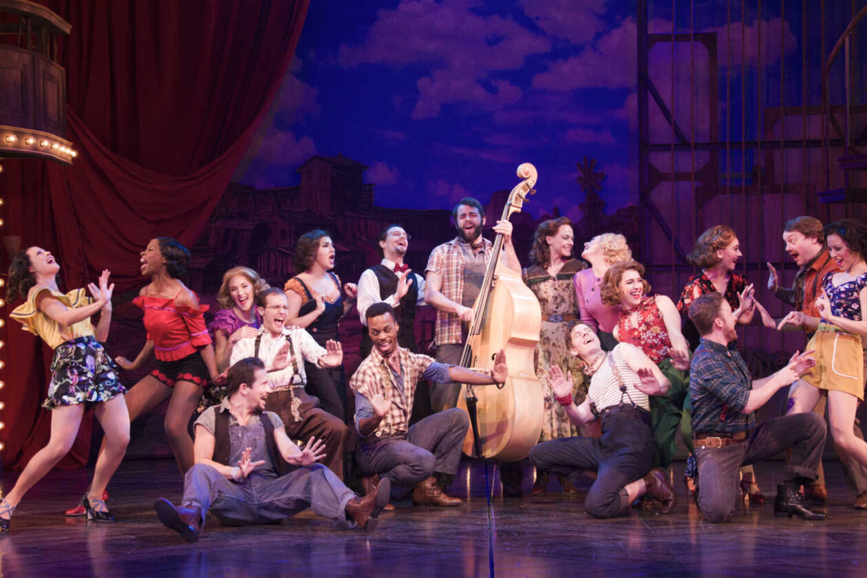
From witty retellings to hyperlocal stories, Shakespeare to contemporary musicals, a wide range of shows is set to hit Arlington theaters this spring and summer.
Next Thursday is the opening night for the musical “Private Jones” (Feb. 6-March 10) at Signature Theatre. The audience will be taken on a journey, based on a true story, of a deaf Welsh sniper during World War I.
Also this spring, Signature will put on “Penelope” (March 5-April 21), which retells Homer’s epic about Odysseus from the perspective of his wife, Penelope, and “Where the Mountain Meets the Sea” (May 21-July 7), which follows a young man who tries to bond with his deceased father by retracing his steps through a journey across America.
Other upcoming Signature shows will let attendees relive the ’60s or experience for the first time and get a behind-the-scenes look at how the Broadway musical “Hair” came to be, leading up to the theater’s performance of the musical from April 16 to July 7.
Shakespeare lovers, meanwhile, can rejoice in a trio of plays this spring.
First up, from this coming Friday to Sunday, theater-goers can see a playwright reckon with Shakespeare’s legacy in “Historic Doubts” by Avant Bard Theatre. The show is being held at Mason Exhibitions Arlington, at 3601 Fairfax Drive in Virginia Square.
Next is Synetic Theater‘s rendition of “Romeo and Juliet” (Feb. 9-March 24), followed by an interactive adaptation of Shakespeare’s “Coriolanus” (Feb. 29-March 23), also by Avant Bard Theatre. In it, the audience becomes “directly involved and implicated in the conditioning of a man” who has been groomed into thinking antisocial brutality is normal.
The Arlington Players (TAP) will reprise the plays-about-plays genre in its two shows this spring. First up, starting this weekend, is “Anton in Show Business” (Feb. 3-18), about the “joys, pains and absurdities of putting on a play.”
Stories about acting continue in the “The Prom” (March 23-April 7) in which four struggling Broadway stars looking for their next break find it in small-town Indiana, where they help a young gay girl best a PTA set on not allowing her to bring her girlfriend to the high school dance. Both TAP productions will be held at Thomas Jefferson Community Theatre (125 S. Old Glebe Road).
Meanwhile, local children’s theater Encore Stage and Studio will start the year with an adaptation of the “Adventures of Swiss Family Robinson” (March 1-10). Director of Marketing and Design Aileen Christian says this show — also held at the Thomas Jefferson Community Center — “is full of humor with talking animals, silly characters, and the beloved treehouse.”
Next, Encore will revisit original theater pieces focused on Arlington’s African-American voices in a double feature of “The Day Nothing Happened” and “Nauck to Green Valley, Transforming a Community” (April 26-28).
Christian says she believes that these stories “share a special meaning right here in Arlington.” The show will take place at Theatre on the Run (3700 S. Four Mile Run Drive).
")
High temperatures in the 60s and 70s for much of the week will not stop a winter tradition in Pentagon City.
The outdoor ice skating rink at 1201 S. Joyce Street officially opened for the season on Wednesday, Nov. 1, a spokesperson for Westpost — the shopping center formerly known as Pentagon Row — confirmed to ARLnow. The opening has yet to be announced on social media.
The seasonal rink in Westpost’s central plaza is billed as one of the biggest in Virginia.
“The Plaza has an outdoor dual-sided stone fireplace and many shops, restaurants and a coffee shop,” says the rink’s website. “Pentagon Row’s 7,200 square foot ice rink is now the largest outdoor rink in Northern Virginia and the second-largest in the state.”
Discounted reservations for up to two hours of skating can be booked online. Admission costs range from $10 to $13 depending on the skater’s age and whether it’s booked online or on-site. Skate rentals are $6, up from $5 two years ago.
Standard rink hours are as follows.
- Sunday: 10 a.m. – 10 p.m.
- Monday: 10 a.m. – 10 p.m.
- Tuesday: Noon – 10 p.m.
- Wednesday: Noon – 10 p.m.
- Thursday: Noon – 10 p.m.
- Friday: Noon – 11 p.m.
- Saturday: 10 a.m. – 11 p.m.
The rink is scheduled to remain open on holidays and public school off-days, sometimes with expanded hours.
The ice skating rink at @PentagonRow (Westpost) is open for the season! 🧊⛸️🛒@NationalLanding @ARLnowDOTcom @ArlingtonVA pic.twitter.com/djMkV8FfsE
— CartChaos22202 (@CartChaos22202) November 4, 2023
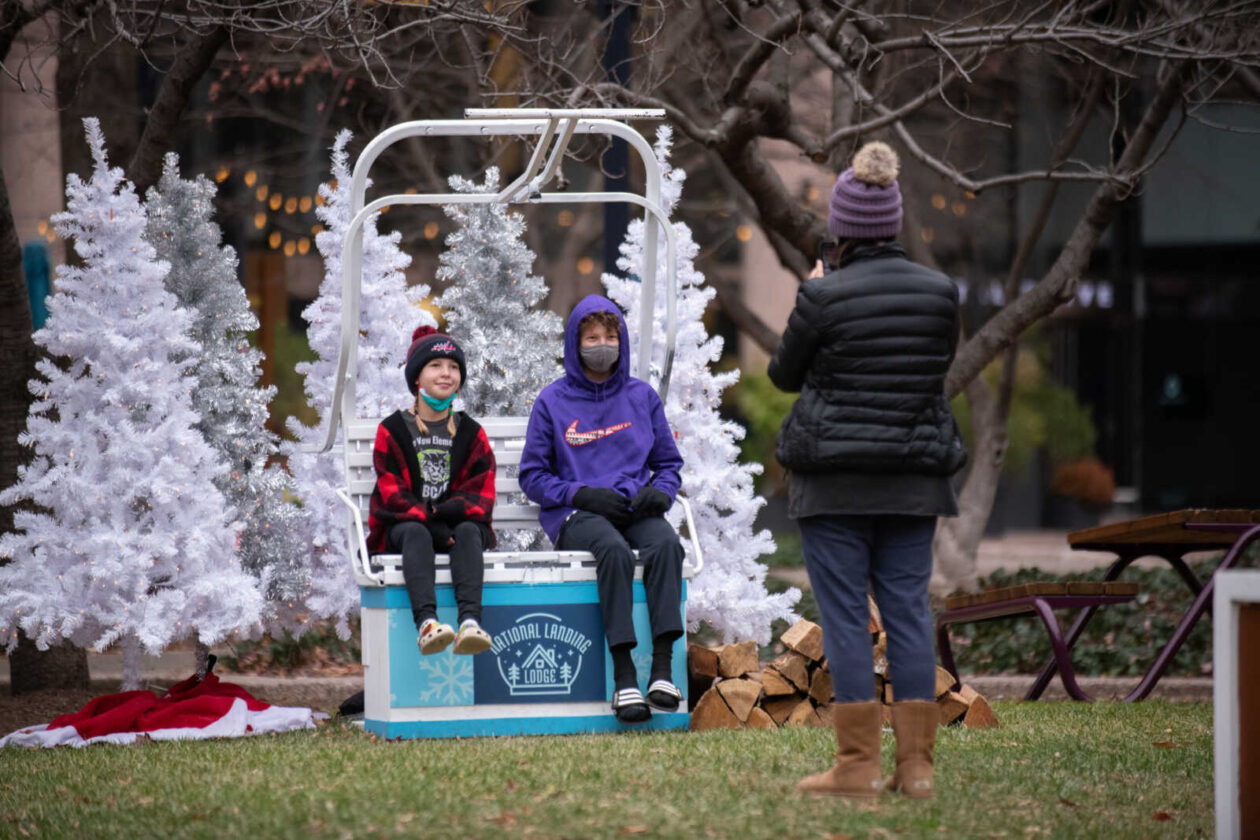
It’s time to dig out those ugly Christmas sweaters and get into the holiday spirit.
The National Landing Business Improvement District is planning a ski-themed holiday festival — dubbed “The Lodge” — at Metropolitan Park in Pentagon City, according to a press release.
It’s happening the first weekend in December — Friday, Dec. 1 through Sunday, Dec. 3 — at the park (1400 S. Eads Street) next to Amazon’s HQ2.
“Guests can savor peppermint mochas and holiday-themed bites from local restaurants, shop for holiday gifts from local artists and adults can stop by Summit Bar for Aprés Ski,” a press release from the BID says.
There are three distinct activity zones named after different ski slope ratings, catering to families, pets and adults.
For the kiddos, “Bunny Hill” offers face painting, photos with Santa, train rides and crafts.
Dog owners can visit the “Blue Run” section, which will have a dog bone bar and pet caricatures. Additionally, there is a holiday market and a pop-up Christmas tree farm. For those needing last-minute holiday cards, a photo booth is also available.
Adults in the mood for some grown-up fun can swing by the DC Fray Summit Bar in the “Black Diamond” section, sporting an ugly sweater, for an après ski spiked hot chocolate or mulled wine. The adults can also try their hand at axe throwing.
The park is accessible on foot or by bike and is a 10-minute walk from the Crystal City Metro Station. For those driving, parking is available along Crystal Drive, according to the release.
The hours of the festival are as follows.
- Friday, Dec. 1 — 5:30-8:30 p.m.
- Saturday, Dec. 2 — 1-8 p.m.
- Sunday, Dec. 3 — 11 a.m. to 5 p.m.

After several years of relatively meager winters, could this upcoming season have a big snowstorm on tap for us?
There’s some early suggestion of an elevated chance of large coastal winter storms between January and March, owing in part to a particularly intense El Niño climate pattern.
Of course, such a pattern could also leave Arlington high and dry again.
“Of the seven strong El Niño winters since 1950, four have been associated with well above normal snowfall while snowfall was virtually absent in the other three winters,” the National Weather Service wrote about winters in metro D.C. and Baltimore.
Climate prognosticating — it’s an inexact science, just ask the groundhog — has been raising the hopes of snow lovers this month, with some models suggesting a cold and snowy winter is likely for the Mid-Atlantic region.
***NEW*** SEASONAL PRECIPITATION OUTLOOK JUST RELEASED. pic.twitter.com/56pnR8HIob
— MWAS-#1 (@SPCMETROWX) September 23, 2023
The latest CFS (Climate Forecasting System) shows a cold winter (Dec,Jan,Feb) for the Mid-Atlantic. pic.twitter.com/cgcEUirMVk
— Russ Adams 🌧️🌬️☀️🌡️🌨️🦃 (@patpend) September 26, 2023
One of many indicators recently. The reason El Nino produces more disruptive snow in the Mid-Atlantic is it creates more nor'easters (half the equation). That means more opportunities for this to sync with cold temperatures (the other half). https://t.co/6cqvJJ6Era
— Russ Adams 🌧️🌬️☀️🌡️🌨️🦃 (@patpend) September 18, 2023
The ECMWF+UKMET superblend* for December 2023-February 2024 is very active along the U.S. East Coast ❄️
Consistent with an El Niño winter, above normal precipitation (🟢) is shown across the Deep South, Southeast, Florida, Mid-Atlantic, and Northeast as well as California.
The… pic.twitter.com/7gHvX121Rr
— Ben Noll (@BenNollWeather) September 11, 2023
The last really big winter storm to hit Arington was the Jan. 22-23, 2016 blizzard. The three large snow events of the winter of 2009-2010, meanwhile, are still fresh in the minds of many locals who lived through them.
What do you think? Would you welcome another big snowstorm this winter or do you prefer the mostly snowless winters of late?
")
Temperatures today could reach 80 degrees, which would surpass the circa-1874 record of 78.
On one hand, it’s hard to argue against temperatures in the 70s in isolation. On the other hand, there is just something disconcerting about experiencing that in February.
WHOA… 80 degrees in February!!?? No snowy photos for us this winter, so taking a blast from winter past! pic.twitter.com/3VEHtbiZw5
— Arlington Fire & EMS (@ArlingtonVaFD) February 23, 2023
It feels like a coda on a weird, mostly snowless winter that has even left the Arlington County Fire Department pining for some actual winter weather.
So what do you think about this weather?
")
(Updated at 7:35 a.m.) Arlington will be under both a Wind Advisory and, later, a Wind Chill Advisory on Friday.
The wind is expected to whip up starting Friday morning, then temperatures will plummet throughout the day. The combination will lead to dangerous conditions for anyone outside.
To make matters worse, the strong winds — gusts of up to 50 mph are expected — may knock out power and leave some locals in the cold.
From the National Weather Service:
737 PM EST Thu Dec 22 2022
…WIND ADVISORY REMAINS IN EFFECT FROM 8 AM TO 2 PM EST FRIDAY…
* WHAT…West winds 20 to 30 mph with gusts up to 50 mph expected.
* WHERE…Portions of central, north central, northeast, northern and southern Maryland, The District of Columbia and central and northern Virginia.
* WHEN…From 8 AM to 2 PM EST Friday.
* IMPACTS…Gusty winds could blow around unsecured objects. Tree limbs could be blown down and a few power outages may result.
* ADDITIONAL DETAILS…Bitterly cold wind chills will be ongoing during the time of this high wind event. It is essential to make preparations now for extreme cold conditions with the potential for loss of power.
PRECAUTIONARY/PREPAREDNESS ACTIONS…
Use extra caution when driving, especially if operating a high profile vehicle. Secure outdoor objects.
Also from NWS:
725 PM EST Thu Dec 22 2022
…WIND CHILL ADVISORY REMAINS IN EFFECT FROM 7 PM FRIDAY TO 10 AM EST SATURDAY…
* WHAT…Very cold wind chills expected. Wind chills as low as 10 below zero.
* WHERE…Portions of central, northeast, northern and southern Maryland, The District of Columbia and central and northern Virginia.
* WHEN…From 7 PM Friday to 10 AM EST Saturday.
* IMPACTS…The cold wind chills could result in hypothermia if precautions are not taken.
* ADDITIONAL DETAILS…The highest wind speeds will be Friday into Friday evening. Affects from the extreme cold could be made worse due to power outages.
PRECAUTIONARY/PREPAREDNESS ACTIONS…
Use caution while traveling outside. Wear appropriate clothing, a hat, and gloves.
Meanwhile, icy roads are possible due to a rapid freeze of wet surfaces following the passing of an arctic front, forecasters say.
ICY ROADS POSSIBLE TODAY for District of Columbia [DC] and Anne Arundel, Calvert, Carroll, Cecil, Central and Eastern Allegany, Central and Southeast Howard, Central and Southeast Montgomery, Frederick, Northern Baltimore, Northwest… till 11:45 AM EST https://t.co/u15MZXIe2h pic.twitter.com/SHJ29bilcc
— WashingtonianWXAlerts (@WashWXGeekAlert) December 23, 2022
Flickr pool photo by Erinn Shirley
")
(Updated at 3:45 p.m.) A major storm affecting most of the eastern U.S. and midwest is set to ramp up tomorrow, making for hazardous holiday travel.
Ahead of the storm, the Virginia Dept. of Transportation sent a clear message this afternoon: start your trip now, if you can.
The storm will mostly bring the D.C. area copious amounts of rain starting Thursday morning, along with gusty winds and bitter cold temperatures on Friday. Frozen precipitation beyond some possible snow flurries is not expected in Arlington, but points west and north will likely see snow, sleet and freezing rain.
Along I-81 and the Blue Ridge, the storm is expected to be a high-impact event, and travel on Thursday is “not advised,” VDOT says.
More from a VDOT press release, below.
The Virginia Department of Transportation (VDOT) is advising motorists traveling in and through Virginia to adjust their holiday travel ahead of winter weather expected in parts of the Commonwealth beginning Wednesday night and continuing through Friday.
Travelers are advised to shift holiday travel to Wednesday if possible. Travel on Thursday is not advised, especially through the western regions of Virginia along the Interstate 81 corridor, to avoid potentially hazardous conditions created by forecasted winter weather.
According to current forecasts, wintry precipitation is expected to arrive as soon as 11 p.m. on Wednesday, Dec. 21 in the southwestern regions of the state, and move northward through the western third of the state, and into portions of northern Virginia through Thursday. Periods of heavy snow are expected along the northern sections of I-81 and the mountain passes including Interstate 64 over Afton Mountain and Rt. 33 between Standardsville and Harrisonburg early Thursday. Temperatures are expected to drop rapidly through the day on Friday leading to the potential for refreeze in areas where the pavement remains wet.
VDOT crews are pretreating roadways and interstates today in anticipation of the weather event.
With extreme low temperatures expected to move in Friday, motorists, if traveling, should pack an emergency kit and blankets, and have mobile devices fully charged in the event of a breakdown or emergency.
“Please continue to monitor forecasts closely as forecasts can improve or worsen quickly,” VDOT said in a separate advisory. “Drivers should expect roads to be impacted Thursday and Friday… Treat anything that looks wet as if it could be icy, especially bridges, ramps, overpasses, and elevated surfaces. If there is snow or ice on roadways, travel is hazardous.”
The transportation agency is currently pretreating roads and “will begin deploying trucks early Thursday morning to treat roads as needed.”
“Adjust travel plans and avoid all nonessential travel during the height of the storm,” VDOT said “This helps to avoid deteriorating conditions and to allow crews room to work.”
A Flood Watch, meanwhile, has been issued for the D.C. area ahead of the rain.
322 PM EST Wed Dec 21 2022
…FLOOD WATCH IN EFFECT FROM THURSDAY MORNING THROUGH LATE THURSDAY NIGHT…
* WHAT…Flooding caused by excessive rainfall is possible.
* WHERE…DC and portions of Maryland and northern Virginia, including the following areas: District of Columbia. In Maryland, Anne Arundel, Cecil, Central and Southeast Howard, Central and Southeast Montgomery, Prince Georges, Southeast Harford and Southern Baltimore. In northern Virginia, Arlington/Falls Church/Alexandria, Fairfax and Prince William/Manassas/Manassas Park.
* WHEN…From Thursday morning through late Thursday night.
* IMPACTS…Excessive runoff may result in flooding of rivers, creeks, streams, and other low-lying and flood-prone locations. Flooding may occur in poor drainage and urban areas.
* ADDITIONAL DETAILS…
– Moderate rainfall is expected Thursday into Thursday evening, with rainfall totals of one to two inches. This may lead to isolated instances of flooding, especially in urban and poor drainage areas.
– http://www.weather.gov/safety/floodPRECAUTIONARY/PREPAREDNESS ACTIONS…
You should monitor later forecasts and be alert for possible Flood Warnings. Those living in areas prone to flooding should be prepared to take action should flooding develop.
VDOT released the following timeline of expected conditions in Northern Virginia and western zones through Christmas.
")
Freezing rain will likely fall early Thursday, prompting a Winter Weather Advisory from the National Weather Service.
Arlington could see dangerous, icy conditions on local roads tomorrow morning, forecasters say. Eventually, the frozen precipitation will switch over to just plain rain as temperatures rise during the day.
Gusty winds are also expected on Thursday.
From from NWS:
…WINTER WEATHER ADVISORY IN EFFECT FROM 10 PM THIS EVENING TO 1 PM EST THURSDAY…
* WHAT…Freezing rain expected. Total ice accumulations of a glaze to around one tenth of an inch.
* WHERE…Portions of central, northeast and northern Maryland, The District of Columbia and northern Virginia.
* WHEN…From 10 PM this evening to 1 PM EST Thursday.
* IMPACTS…Difficult travel conditions are possible. The hazardous conditions will likely impact the morning commute on Thursday.
* ADDITIONAL DETAILS…Wintry precipitation begins this evening, then becomes more intense tonight into Thursday morning. Warmer air should push in Thursday afternoon changing the precipitation to rain.
PRECAUTIONARY/PREPAREDNESS ACTIONS…
Slow down and use caution while traveling.
When venturing outside, watch your first few steps taken on steps, sidewalks, and driveways, which could be icy and slippery, increasing your risk of a fall and injury.
Ice Storm Warnings and Winter Weather Advisories have been issued. Significant icing is likely along and west of the Blue Ridge tonight through Thursday. Ice amounts of 0.25-0.75" are expected. Further east, up to 0.10" of ice is expected north & west of I-95. pic.twitter.com/RamBGLy4gN
— NWS Baltimore-Washington (@NWS_BaltWash) December 14, 2022
The Capital Weather Gang says Arlington is on the approximate line between some ice accumulation and mostly wet roads, with northern portions of the county likely seeing more ice.
D.C.-area forecast: Thursday morning icy spots for some, then a soaking afternoon rain https://t.co/nRN5vXUCxN
— Capital Weather Gang (@capitalweather) December 14, 2022
VDOT, meanwhile, says it’s preparing to do battle with Mother Nature and try to keep roads passable.
From a VDOT press release:
The Virginia Department of Transportation (VDOT) is mobilizing its equipment and resources in preparation for a winter weather event to impact parts of the Commonwealth Wednesday night into Thursday.
Incoming rain throughout Virginia is forecasted to shift to sleet and freezing rain in the northern, northwestern, and central areas of the Commonwealth beginning around 10 p.m. on Wednesday, Dec. 14 and going through the morning of Thursday, Dec. 15. This weather event is expected to impact VDOT’s Staunton, Salem, Culpeper, Northern Virginia and Lynchburg districts.
VDOT is paying close attention to the forecast and preparing for what could be a significant icing event. District crews will not apply liquid pretreatment to roads in areas where the event is forecasted to start as rain, which will wash away the pretreatment application. Crews are preparing equipment and will be ready to treat roadways with salt, sand and abrasives as precipitation transitions to sleet or freezing rain.
Motorists should pay attention to weather forecasts in areas where they plan to drive and delay travel on Thursday morning in the impacted areas, especially along the I-81 corridor, Culpeper and Northern Virginia regions.
Safety and Travel Resources
When winter weather arrives, residents and motorists should plan travel ahead of time, check road conditions, prepare an emergency car kit, follow forecasts and announcements and limit travel based on conditions. […]
Statewide Improvements for the 2022-2023 SeasonIn addition to its traditional year-round snow preparation, VDOT made improvements to address items from the Snow Removal and I-95 Incident Performance Audits by the State Inspector General and the Winter Weather Event and I-95 Interagency After-Action Report by CNA:
Improved contracting to be more flexible, competitive and attractive to contractors to address equipment and personnel shortages.
Improved communications and command structure for better internal and interagency cooperation during crisis events.
Assigned staff to drive routes and report on conditions to supplement traffic cameras.
Acquired a system to allow two-way communications between drivers and VDOT within a defined geographic area.
Continued participation in winter weather exercises, led by The Virginia Department of Emergency Management, to foster interagency cooperation.
Resources and Readiness
In addition to operational improvements, VDOT maintains a number of resources to contend with inclement weather.
- $220 million statewide budgeted for winter weather in 2022-2023
- 11,493 pieces of equipment (VDOT-owned and contracted equipment combined, as of Nov. 30)
- Approximately 1,148 vehicle contracts in process, and is continuing to receive additional contract bids (as of Nov. 30)
- More than 696,000 tons of salt, sand and treated abrasives, and more than 2.3 million gallons of liquid calcium chloride and salt brine.
")
NBC 4 Chief Meteorologist Doug Kammerer revealed his annual winter forecast last night — and it was disappointing if you like snow.
Doug is calling for a measly 1-6 inches of snow during the entire winter in Arlington and D.C. He believes it will be an unusually warm and wetter than average winter, making for plenty of cold rain but very little snow.
It follows a trend: five of the six most recent winters in the D.C. area have seen below average snowfall, Kammerer said.
Long-range forecasting is far from an exact science and there are other predictions that call for more snow. The meteorologists at WUSA 9 and Fox 5 are both calling for average to above average snowfall. The Farmer’s Almanac, meanwhile, while decidedly not a scientific authority, is predicting above average snowfall and below average temperatures for the region.
Should Kammerer’s prediction come to pass and we see six or fewer inches of snow this winter, how would you feel about it?
")
An event in Rosslyn this week is hoping to help local singles prepare for “cuffing season,” the time of the year when some are looking to settle down with a partner to pass the cold months.
On Wednesday (Nov. 16) at 5:30 p.m., the Rosslyn Business Improvement District is hosting its first-ever Cuffing Season Tips & Sips at Assembly food hall at 1700 N. Moore Street.
The event will feature a chance to mingle with other singles, an onsite photographer to take that “perfect profile photo,” and advice from online dating coach Erika Ettin.
Registration is required with the event costing $10 in advance and $15 at the door. Attendees will get one drink per admission plus a happy hour menu will be available.
Cuffing season, per Merriam-Webster, “refers to a period of time where single people begin looking for short-term partnerships to pass the colder months of the year.” It starts in October and lasts until after Valentine’s Day.
Due to the pandemic, the last two cuffing seasons have been rough for singles looking to cozy down for the winter. This year’s rendition appears to be approaching normalcy, with other local events looking to encourage the ritual.
Besides mingling and freshening up that online dating photo, Rosslyn BID is bringing in a well-regarded local online dating coach to provide advice. Erika Ettin is the founder of “A Little Nudge,” a service that helps singles manage online profile creation and date planning as well as coaching.
Ettin will be at the event “to give you the best tips on how to improve your dating profile to help you find the perfect match,” reads the event page.