")
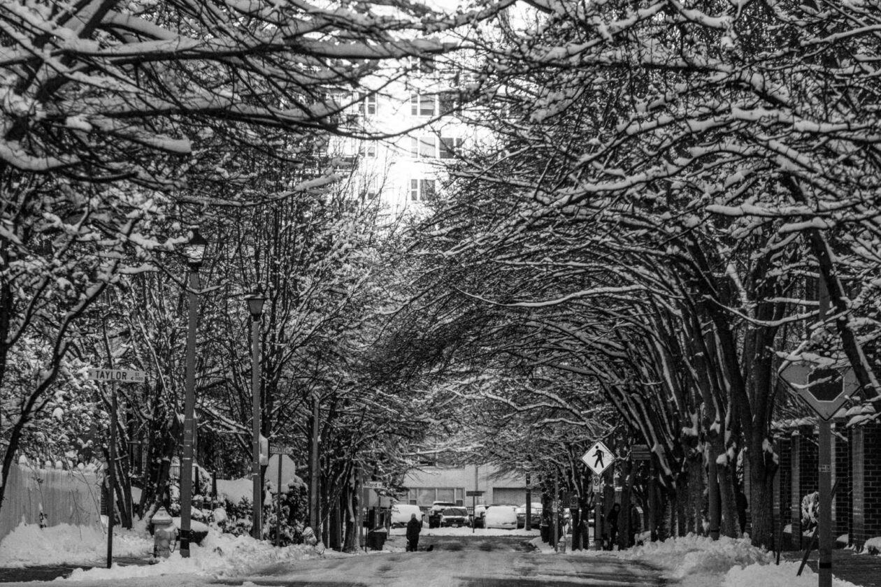
Get ready for a wintry and windy Saturday.
A Winter Weather Advisory and Wind Advisory, both of which take effect Saturday morning, were just issued for Arlington. Forecasters expect wind gusts up to 55 mph and snow accumulation of 2-4 inches as a storm system moves up the East Coast.
From the National Weather Service:
325 PM EST Fri Mar 11 2022
…WINTER WEATHER ADVISORY IN EFFECT FROM 7 AM TO 3 PM EST SATURDAY…
* WHAT…Snow expected. Total snow accumulations of 2 to 4 inches. Northwest winds will gust around 45 to 55 mph.
* WHERE…Portions of central and northeastern Maryland, northern and central Virginia, and the District of Columbia, including most of the DC and Baltimore metros.
* WHEN…From 7 AM to 3 PM EST Saturday. Rain will change to snow between 7 and 9 AM early Saturday. The steadiest snow will be through Saturday morning.
* IMPACTS…Plan on slippery road conditions. Gusty winds could bring down tree branches.
* ADDITIONAL DETAILS…Visibility may be reduced to below one- quarter mile at times. Brief near blizzard conditions are possible between 8 and 11 AM.
PRECAUTIONARY/PREPAREDNESS ACTIONS…
Slow down and use caution while traveling.
When venturing outside, watch your first few steps taken on steps, sidewalks, and driveways, which could be icy and slippery, increasing your risk of a fall and injury.
Also from NWS:
326 PM EST Fri Mar 11 2022
…WIND ADVISORY IN EFFECT FROM 6 AM SATURDAY TO 1 AM EST SUNDAY…
* WHAT…Northwest winds 25 to 35 mph with gusts up to 55 mph.
* WHERE…Portions of northern and central Maryland, northern Virginia, and the District of Columbia including the DC and Baltimore metro areas.
* WHEN…From 6 AM Saturday to 1 AM EST Sunday.
* IMPACTS…Gusty winds could blow around unsecured objects. Tree limbs could be blown down. Several power outages may result.
* ADDITIONAL DETAILS…A few gusts to around 60 mph are possible. Strong winds may persist into early Sunday morning.
PRECAUTIONARY/PREPAREDNESS ACTIONS…
Use extra caution when driving, especially if operating a high profile vehicle. Secure outdoor objects. Prepare for power outages.
The Washington Post’s Capital Weather Gang is a bit more measured in terms of its snow accumulation prediction for Arlington, calling for a coating to 2-3 inches of snow accumulation, with higher amounts north and west.
The storm is expected to start as rain before changing over to snow mid-morning. In such scenarios, snows crews typically do not pre-treat roadways as the treatment would be washed away by the time the frozen precipitation starts.
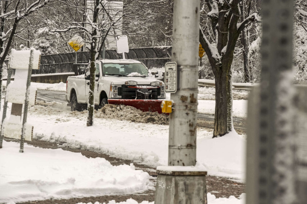
VDOT said Friday afternoon that its plow crews are ready to tackle the snowy onslaught, while asking drivers to stay at home if at all possible.
VDOT Northern Virginia crews are ready for winter weather that is forecast to impact the region Saturday. The forecast shows precipitation starting as rain and turning to snow. Residents should be ready for high wind gusts and below freezing temperatures.
As always, residents are asked to monitor forecasts and plan ahead to avoid nonessential travel during winter weather.
What’s Happening Now
- See the Winter Weather Advisory from the National Weather Service for precipitation for Saturday. The forecast includes periods of rain and accumulating snow, as well as increased winds. Please continue to monitor forecasts closely as forecasts can improve or worsen quickly.
- Crews will mobilize overnight to treat state-maintained roads. Please drive with caution around plow trucks as they are heavy and move slowly.
- Temperatures are expected to drop below freezing, causing potential icy conditions. Treat anything that looks wet as if it could be icy, especially bridges, ramps, overpasses, and elevated surfaces. If there is snow or ice on roadways, travel is hazardous.
Storm response crews will be ready for possible accumulations/icy conditions from tomorrow's expected late winter event. Remember: Plowing only takes place with at least 2 inches of snow on roads. Know the phases: https://t.co/DuInmBchJW #ArlWX pic.twitter.com/va1nYDBlGh
— Arlington Department of Environmental Services (@ArlingtonDES) March 11, 2022
Winter Weather Advisories have been expanded eastward to include much of the I-95 corridor for Saturday morning. Wind Advisories are also in effect for much of the area. This paired with heavy, wet snowfall could lead to some power outages, especially where heaviest snow falls. pic.twitter.com/Ia9bez8Wt2
— NWS Baltimore-Washington (@NWS_BaltWash) March 11, 2022
")
March: when it can be nearly 80 degrees one day and under 40 degrees the next. And in Arlington, the month marks the start of pothole filling and street repaving season.
There are 1,059 lane miles of roadway in Arlington County, and every March, the Arlington Department of Environmental Services launches its effort to fill in potholes caused by winter freezes and repave about 7-8% of roads.
The 2022 repaving season is kicking off with fewer pothole service requests while DES aims to repave 74 lane miles of road, spokesman Peter Golkin tells ARLnow.
This goal is about on-pace with the number of miles the department has repaved in recent years, according to data from DES.
Baseball and street paving. Only one season begins at the end of March as planned. See if your street is in play:https://t.co/J1dZd9NqO2. pic.twitter.com/Kyys3oyrf2
— Arlington Department of Environmental Services (@ArlingtonDES) March 8, 2022
But first, crews are attending to the potholes. Street repaving will begin later this month.
“March is generally the unofficial start of the pothole filling season as winter storm weather recedes and staff can focus on road conditions rather than storm response,” Golkin said.
So far, county crews have filled 462 potholes, of which 360 were filled in February, he says. Meanwhile, there have been about 254 pothole service requests filed by residents since Jan. 1, according to data from the county.
The number of potholes on local roads has generally declined over the last five years due in part to milder winters, compared to the colder, harsher winters in years past that caused thousands of potholes. The winter of 2019 broke that downward trend with more than 5,100 potholes, however.
“2019 stands out for a 10-inch snow event and about a dozen events total whereas the past couple of years have been much milder,” Golkin said.
This year also saw a few winter storms and extended bouts of freezing temperatures, which precipitated hundreds of water main breaks in Arlington. But the “historically snowy January” gave way to a mild February and — overall — a milder than normal winter for the sixth time in the past seven years, according to the Washington Post’s Capital Weather Gang.

But potholes are not just declining because of weather, says the county’s sewers and streets bureau spokesman. Another factor is the county’s stepped-up repaving schedule over the last eight years.
“As the County invests more in paving and the overall street Pavement Condition Index (PCI) increases, the overall number of pothole fill requests trend downward,” Golkin said.
The index increased from a low of 67 out of 100 in 2014 — the result of years of anemic repaving rates — to 80.2 in 2020. Arlington achieved this lift after tripling the number of annual road miles paved.
Now, the county aims to repave 72 to 75 lane miles every year in order to maintain a score between 75 and 80, per the adopted 2021-22 fiscal year budget.

Road users can expect this work to start later this month and to continue through early fall.
“Paving season traditionally runs from the end of March to the end of September, but weather and contractor availability can push things back,” Golkin said. “A segment of planned paving may be shifted to another year for various reasons including nearby new utility work or a construction project nearby that’s fallen behind schedule.”
")
Arlington is expected to get 1-2 inches of snow tomorrow, prompting the National Weather Service to issue a Winter Weather Advisory this morning.
The advisory cautions against slippery conditions on local roads as a result of the snow, which is expected to start falling overnight. The snow should wrap up before the kickoff of the Super Bowl Sunday evening.
The advisory from NWS is below.
1000 AM EST Sat Feb 12 2022
…WINTER WEATHER ADVISORY IN EFFECT FROM 1 AM TO 4 PM EST SUNDAY…
* WHAT…Snow expected. Total snow accumulations of 1 to 2 inches, with up to 4 inches locally.
* WHERE…The District of Columbia, portions of central, northeast and northern Maryland and central, northern and northwest Virginia.
* WHEN…From 1 AM to 4 PM EST Sunday.
* IMPACTS…Plan on slippery road conditions.
* ADDITIONAL DETAILS…The heaviest accumulations will be on non-paved surfaces.
PRECAUTIONARY/PREPAREDNESS ACTIONS…
Slow down and use caution while traveling.
When venturing outside, watch your first few steps taken on steps, sidewalks, and driveways, which could be icy and slippery, increasing your risk of a fall and injury.
Storm response crews will be standing by overnight. Know the phases. #ArlWX https://t.co/DuInmBchJW https://t.co/37zVevpWlI
— Arlington Department of Environmental Services (@ArlingtonDES) February 12, 2022
")
Punxsutawney Phil, the world’s most famous weather-forecasting groundhog, saw his shadow Wednesday morning, thus predicting six more weeks of winter.
“As I look over the faces of the true believers from around the world, I bask in the warmth of your hearts, I couldn’t imagine a better fate, with my shadow I have cast than a long, lustrous six more weeks of winter,” Phil said in a statement, as read by a member of the Punxsutawney Groundhog Club’s Inner Circle.
Setting aside questions of Phil’s forecast accuracy raised by naysayers like the National Weather Service, how do you feel about the prospect of six more weeks of winter here in Arlington, after a relatively cold and snowy January?
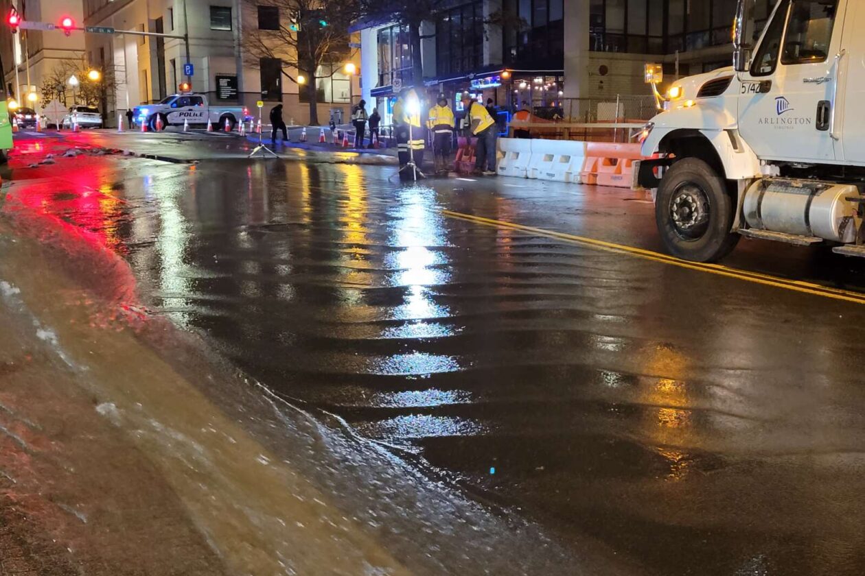
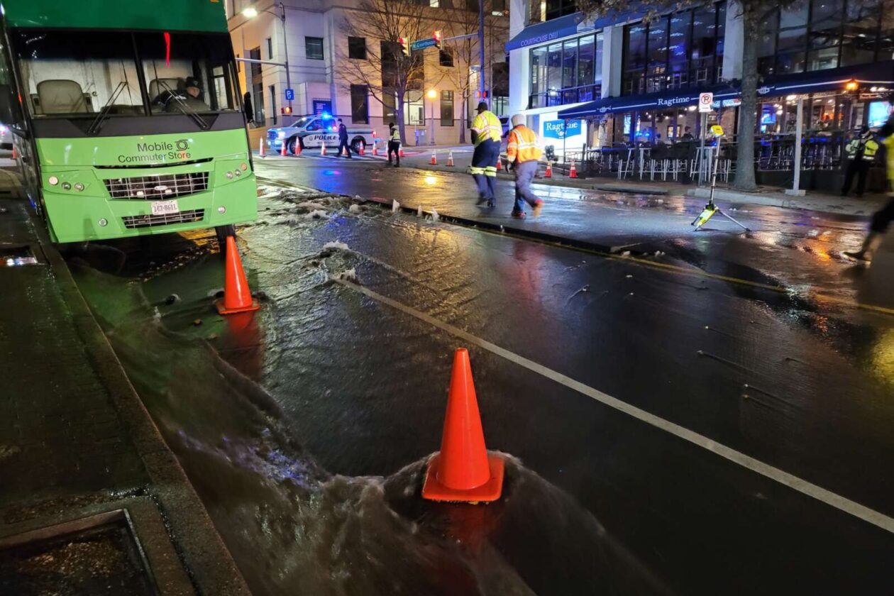
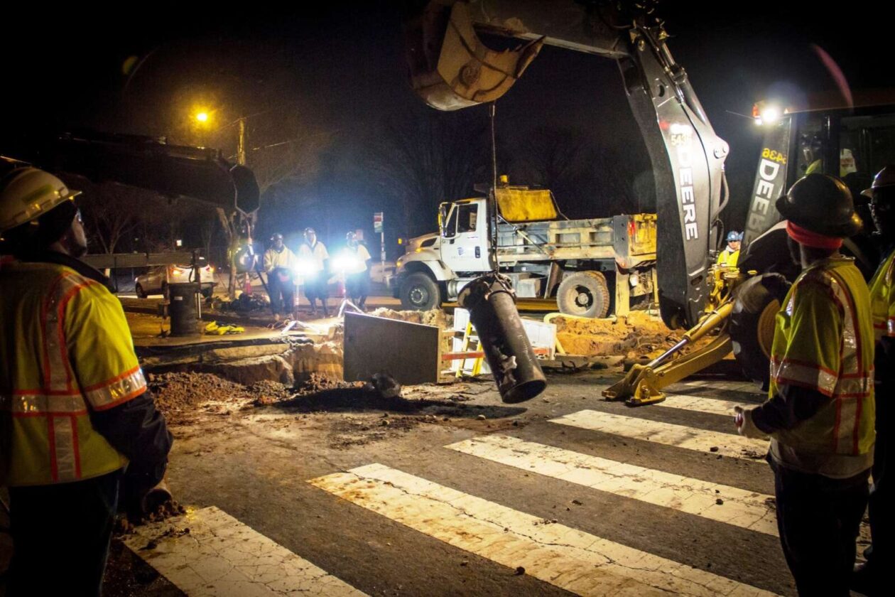
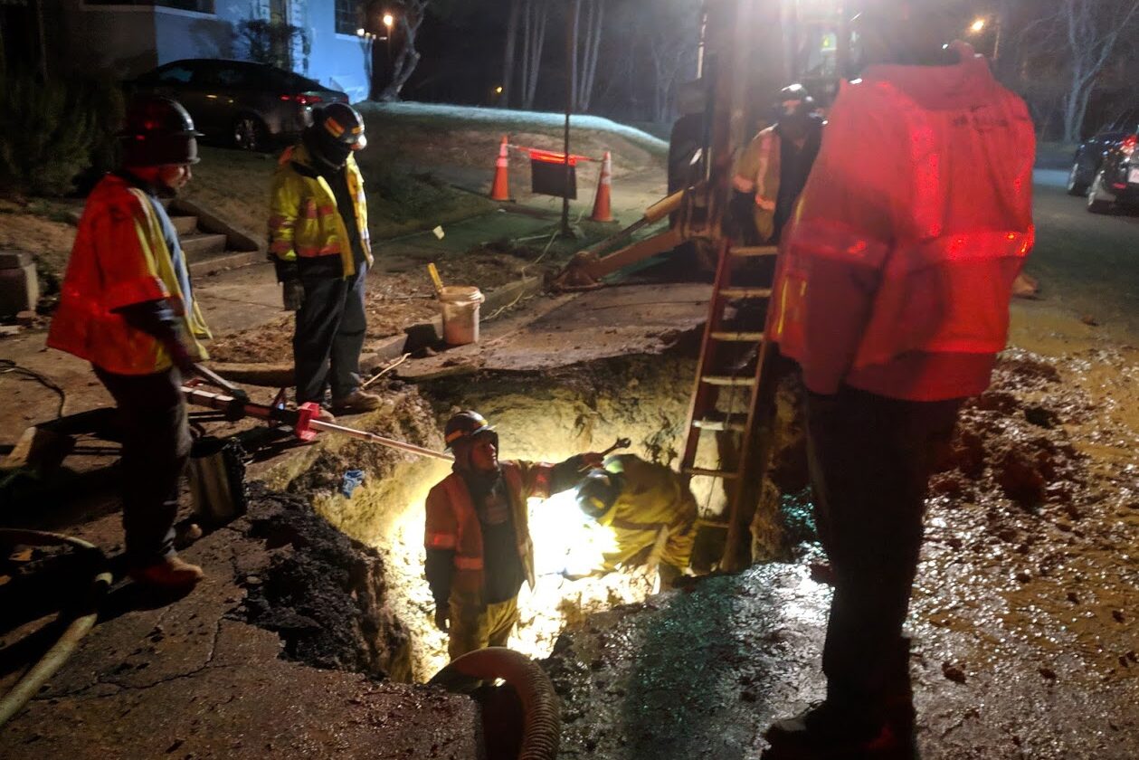
This winter’s storms and freezing temperatures have caused a spike in water main breaks.
Crews with the Department of Environmental Services’ Water, Sewer and Streets Bureau repaired 47 water mains in January, as of 6 p.m. Monday, with two repairs in progress and six planned, said DES spokesman Peter Golkin.
By comparison, January 2021 saw 30 main breaks, up from 19 in January 2020 and eight in January 2019, he noted.
Since Golkin provided those stats last night, two additional water main breaks have been publicly reported, in East Falls Church and Green Valley.
Golkin, who runs the DES Twitter feed, attributed the “above-average number of water main breaks” to “an unusually intense winter” in a recent tweet.
“Recent winters have been fairly mild,” Golkin tells ARLnow. “But we are seeing an upward trend for breaks over the past four years.”
Winter weather exacerbates the other reasons these mains break: age and materials used. Rehabilitating and replacing old water mains has been and continues to be a decades-long county effort.
Arlington has about 500 miles of pipes that bring water to homes and businesses. Of those, about 60% are cast iron pipes more than 50 years old — and thus prone to leaking.
“So age is a factor in the sense of which type of iron we’re dealing with,” he said. “Arlington’s cast iron pipes were not lined with a protective coating to prevent corrosion. While for the most part they’re in good condition, over time the inner and outer diameter thins. Then, factor in winter and the differences in temperature between pipe, water and surrounding soil and you get stresses on the pipes.”
When mains break, crews stop the flow of water, which can cause temporary service disruptions to some properties. Repairs can take six to eight hours from when leaks are reported but could take longer if they’re on a major water line and involve significant damage.
And right now, responding to leaks is a grueling job, Golkin says.
“Crew safety and health is always the preeminent concern in responding, especially with bitter temperatures, darkness and Covid protocols,” he said. “But our professionals know what’s required and can usually complete a job in 6-8 hours despite all sorts of conditions. And they have to be prepared around the clock, seven days a week.”
Saluting the Water, Sewer, Streets Bureau professionals who, in an unusually intense winter, make massive water main breaks look like they never happened. Literally the difference between night and day in less than 24 hours. #TheOtherFirstResponders https://t.co/8YbKyxDQSg pic.twitter.com/QWElkH1g5b
— Arlington Department of Environmental Services (@ArlingtonDES) January 23, 2022
Per location data from the county’s online map of leaks and repairs, crews had to respond to the same address twice in a half-dozen recent cases. Golkin says that’s typical.
“Repairing a water main naturally generates stress on the line, which can lead to nearby follow-up breaks,” Golkin said. “So if a certain neighborhood has had a repair, then there’s an increased chance that another problem might soon develop on the same block.”
When multiple leaks happen concurrently, the bureau prioritizes repairs based on the number of residents impacted, he said.
“DES prioritizes by the impact of each break, so if there is a repair needed in a residential neighborhood, that would get first attention compared to a break next to office buildings closed for the night or a weekend,” Golkin said. “Sometimes a break doesn’t mean a loss of water service, possibly due to redundancy in the water main network. That can give the bureau flexibility in scheduling a repair.”
")
This week was yet another filled with plenty of news about snow, but unlike previous January weeks not a lot of actual snow.
Using its last traditional snow day allotment, Arlington Public Schools closed Thursday for what turned out to be a bust — a rainy, cold day. Lucky for students looking to enjoy the weather when school’s closed, this weekend should at least be sunny, albeit a little cold, in Arlington.
Now, here are the most-read Arlington articles of the past week.
- Feds release new details about Jan. 6 weapons cache at Arlington hotel
- JUST IN: Winter Weather Advisory issued ahead of Thursday morning snow
- BREAKING: APS closes schools Thursday due to expected snow
- Morning Poll: Should APS continue to require masks in schools?
- The shift from rain to snow delayed in Arlington, NWS decreases possible accumulation
- Guaranteed income pilot program moves forward without any county funding
- NEW: Covid cases falling in Arlington, following regional trends
- Winter Restaurant Week to feature 18 Arlington restaurants
- ‘Old Lee Highway’ gets new name: Cherry Hill Road
- JUST IN: APS says masks still required for students, despite Youngkin’s order
Feel free to discuss those stories or anything else of local interest in the comments. Have a great weekend!
")
The National Weather Service issued a Winter Weather Advisory for Thursday morning, saying it expects between up to 2 inches of snow.
The advisory is set for between 6 a.m. and 1 p.m. NWS forecasts rain and snow before noon, followed by a chance of snow between noon and 3 p.m. as temperatures fall to around 30 by 5 p.m.
The snowfall could bring closures, as Fairfax County schools already announced a virtual learning day.
The Capital Weather Gang says the timing of the expected snow could lead to a bad morning commute.
“As a strong cold front pushes south, rain will change to snow, which could be heavy for a time between about 7 and 10 a.m.,” according to the Capital Weather Gang. “It will probably too warm for the snow to stick at first. But, as temperatures fall, slick spots could develop, especially in our colder areas north and west of the Beltway.”
See the full advisory below.
…WINTER WEATHER ADVISORY IN EFFECT FROM 6 AM TO 1 PM EST
THURSDAY…* WHAT…Snow. Snow accumulations of up to two inches with locally
higher amounts around three inches possible.* WHERE…The District of Columbia, portions of central, northern
and southern Maryland, and central and northern Virginia.* WHEN…From 6 AM to 1 PM EST Thursday.
* IMPACTS…Plan on slippery road conditions. The hazardous
conditions will impact the morning commute.* ADDITIONAL DETAILS…Precipitation will start as rain and then
switch over to snow during the Thursday morning commute.
Instructions: Slow down and use caution while traveling. When venturing outside, watch your first few steps taken on steps, sidewalks, and driveways, which could be icy and slippery, increasing your risk of a fall and injury.
Target Area:
Arlington, Falls Church, Alexandria
Fairfax
Prince William, Manassas, Manassas Park
Southern Fauquier
Spotsylvania
Stafford
A mild day today ahead of a cold front moving through tonight. Light snow accumulations are possible into Thu morning. Conditions turn colder and more blustery thereafter. Still monitoring the winter storm threat on Fri evening into Sat morning. #MDwx #VAwx #DCwx #WVwx pic.twitter.com/Lj85Ln61r9
— NWS Baltimore-Washington (@NWS_BaltWash) January 19, 2022
")
Arlington — and much of the D.C. region — is now officially under a Winter Storm Watch.
The watch was issued just before 3 p.m. Forecasters are calling for up to 5 inches of accumulating snow, but 1-3 inches is most likely, according to the National Weather Service.
Gusty winds will accompany the storm and, paired with the snowfall, could fell tree branches and cause another bout of power outages.
From NWS:
URGENT – WINTER WEATHER MESSAGE
National Weather Service Baltimore MD/Washington DC
251 PM EST Fri Jan 14 2022…WINTER STORM WATCH IN EFFECT FROM SUNDAY AFTERNOON THROUGH MONDAY MORNING…
* WHAT…Significant snow and wintry precipitation possible. Total snow accumulations of 1 to 3 inches are most likely, with up to 5 inches possible. Ice accumulations of up to one tenth of an inch are possible. Winds could gust as high as 45 mph.
* WHERE…The District of Columbia, portions of central and northern Maryland, and central and northern Virginia.
* WHEN…From Sunday afternoon through Monday morning.
* IMPACTS…Plan on slippery road conditions. The hazardous conditions could impact the Monday morning commute.
* ADDITIONAL DETAILS…Snow may fall at 1 to 3 inches per hour late Sunday afternoon and early Sunday evening, resulting in nearly impassable roads.
PRECAUTIONARY/PREPAREDNESS ACTIONS…
Monitor the latest forecasts for updates on this situation.
Ahead of the storm, which is expected to have more severe impacts west of the D.C. area, Virginia Gov. Ralph Northam today declared a state of emergency.
“We expect this storm to have a significant impact in many parts of Virginia,” Northam said in a statement. “Declaring a state of emergency now allows our emergency responders to prepare, and to move supplies and equipment where they expect to need them the most. This also gives Governor-elect Youngkin the ability to respond to any storm needs swiftly. I urge Virginians to take this storm seriously and make preparations now.”
Arlington County and VDOT crews, meanwhile, have been pre-treating roads in advance of the winter weather, which is expected to start as snow Saturday afternoon before transitioning to sleet, freezing rain and then plain rain.
We can't rule out power outages Sunday night, especially in our western areas due to 30-40 mph wind gusts + snow/ice on tree limbs. Up to 0.25" ice in some spots. Ice map from @NWS_BaltWash pic.twitter.com/gg9dv8HDg0
— Capital Weather Gang (@capitalweather) January 14, 2022
The NWS has issued a Winter Storm Watch for all counties along and WEST of I-95, including DC, Fairfax, Arlington, Montgomery and those West. This is for Snow and Ice accumulations. I will have my updated SNOW map at 4,5 & 6 today on News4! pic.twitter.com/oIX4PTKFt1
— Doug Kammerer (@dougkammerer) January 14, 2022
https://twitter.com/VaDOTNOVA/status/1482081483644973059
It’s been tough sledding, so to speak, for Arlington snow crews this week.
With the help of some milder temperatures, crews have nearly completed their snow removal effort following Monday’s winter storm. But with another storm looming tonight, threatening another 2-4 inches of snow, there will not be time to rest.
“Arlington crews continue to clear the remnants of Monday’s storm ahead of this next event, moving in tonight,” said Peter Golkin, spokesman for the county’s Dept. of Environmental Services. “They’re clearing intersections and turn lanes while pre-treating bridges and other key spots with brine and salt.”
Officials today revealed more details about the challenges the county faced in dealing with a major snowstorm during a Covid wave and at the end of a holiday weekend.
“Just a few days out, forecasts did not anticipate Monday’s event and the first indication of a significant weather event was issued Sunday morning at 4:30 a.m.,” Golkin recounted. “Arlington crews worked through Sunday to load salt spreader V-boxes, attach plows and mobilize equipment for the response as most Arlington equipment is multi-purpose as part of year-round operations.”
Indeed, as of Saturday (New Year’s Day) morning, two days before the storm, forecasters were only calling for “relatively light precipitation” and limited accumulation, in part because Sunday was expected to be warm and the precipitation would start as rain.
“Roads were not pretreated because the incoming Monday system, as forecast, began with heavy rain, which washes away brine, making it useless,” Golkin noted
By Monday evening, after 6-10 inches of snow fell, the county acknowledged what many locals observed: streets were not getting cleared as quickly as in past storms. While Arlington and other D.C. area jurisdictions don’t have the snow removal firepower of more northern locales with more frequent significant snow events, the plowing was taking longer than usual.
The county blamed “COVID19-related staffing shortages.”
LOCATION:County Wide
INCIDENT: County Snow Removal Update
IMPACT: The County's snow removal is currently impacted by COVID19-related staffing shortages. Roads are being cleared as quickly and safely as possible. Thank you for your patience and understanding. View the Arlington s— Arlington Alert (@ArlingtonAlert) January 3, 2022
“Our first Monday team was at approximately 50% of typical response, due to staffing shortages from the direct or collateral impact of COVID, plus the challenges of people returning from a scheduled holiday weekend,” Golkin said this morning. “Monday’s second shift starting at noon was further hampered when members who live far from Arlington got caught in traffic backups including at least eight stranded for more than 20 hours on I-95.”
“Our contractors for additional trucks had the same issues and were naturally in high demand across the region,” the spokesman added. “By Tuesday afternoon, we had mobilized above the 75% of County level for a typical big response and supplemented with contractor resources.”
Now with another storm looming, county and state officials are sounding a louder alarm — even with lower anticipated snowfall totals.
“With the National Weather Service calling for another significant round of winter weather making its way across Virginia Thursday night (Jan. 6) into Friday morning (Jan. 7), the Virginia State Police are encouraging Virginians to be weather aware… to plan ahead… and to avoid traveling during inclement conditions,” state police said today.
Virginia Gov. Ralph Northam has even declared a preemptive state of emergency.
")
More snow is on the way.
The National Weather Service just issued a Winter Weather Advisory, saying 2-4 inches of accumulation is likely between Thursday night and Friday morning.
The snowfall could bring more travel disruptions and closures. It follows three days of school closures in Arlington after a winter storm dropped 6-10 inches of snow on Monday.
From NWS:
233 PM EST Wed Jan 5 2022
…WINTER WEATHER ADVISORY IN EFFECT FROM 9 PM THURSDAY TO 5 AM EST FRIDAY…
* WHAT…Snow. Total snow accumulations 2 to 4 inches. Isolated high amounts of around 5 inches are possible.
* WHERE…The District of Columbia, portions of northern and central Maryland, and northern Virginia.
* WHEN…From 9 PM Thursday to 5 AM EST Friday.
* IMPACTS…Plan on slippery road conditions. The hazardous conditions could impact the Friday morning commute.
* ADDITIONAL DETAILS…The heaviest snow is expected between 10 PM and 2 AM when snowfall rates of 1 inch per hour are possible.
PRECAUTIONARY/PREPAREDNESS ACTIONS…
Slow down and use caution while traveling.
When venturing outside, watch your first few steps taken on steps, sidewalks, and driveways, which could be icy and slippery, increasing your risk of a fall and injury.
More from social media:
https://twitter.com/ReadyArlington/status/1478782959943659520
Here we go again! Another SNOW event moving into our region Tomorrow night into Friday Morning. A Winter Weather Advisory is in effect for the entire area. I am expecting 2-3" for most of us, maybe a little more, but this is NOT a huge storm, still impactful. See you at 4,5&6! pic.twitter.com/d34A7NSq78
— Doug Kammerer (@dougkammerer) January 5, 2022

Update at 3:15 p.m. — Both Arlington County and VDOT say snow crews are preparing for the storm.
“Throughout overnight hours, crews and about 2,200 trucks will be staged and ready to treat roads and plow snow where needed,” VDOT said Sunday afternoon. “Crews will begin to plow once two inches of snow have accumulated.”
A variety of useful web pages before, during and after a winter storm: https://t.co/lrQcIzwapY. pic.twitter.com/GZMbqxPfx4
— Arlington Department of Environmental Services (@ArlingtonDES) January 2, 2022
Update at 2:50 p.m. — The earlier Winter Storm Watch has been updated to a Winter Storm Warning. The forecast still calls for 3 or more inches of snow falling Monday morning.
233 PM EST Sun Jan 2 2022
…WINTER STORM WARNING IN EFFECT FROM 1 AM TO 4 PM EST MONDAY…
* WHAT…Heavy snow. Total snow accumulations of 3 to 7 inches. Winds gusting as high as 35 mph.
* WHERE…The District of Columbia, portions of central Maryland and northern Virginia.
* WHEN…From 1 AM to 4 PM EST Monday.
* IMPACTS…Travel could be very difficult. The hazardous conditions could impact the morning or evening commute.
PRECAUTIONARY/PREPAREDNESS ACTIONS…
If you must travel, keep an extra flashlight, food, and water in your vehicle in case of an emergency.
When venturing outside, watch your first few steps taken on steps, sidewalks, and driveways, which could be icy and slippery, increasing your risk of a fall and injury.
Winter Storm Warnings and Advisories expanded with more snow now forecast. pic.twitter.com/Pkr2lThSmk
— NWS Baltimore-Washington (@NWS_BaltWash) January 2, 2022
Earlier: Arlington and the D.C. area could get the first significant snowfall of the season tomorrow.
Heavy snow with up to 3-6 inches of accumulation is possible Monday, starting late tonight, according to the National Weather Service, which issued a Winter Storm Watch for Arlington County and other parts of the region early this morning.
Arlington is just on the northern edge of the Winter Storm Watch, meaning that southern parts of the county may get more snow than northern parts.
More from NWS:
428 AM EST Sun Jan 2 2022
…WINTER STORM WATCH IN EFFECT FROM LATE TONIGHT THROUGH MONDAY AFTERNOON…
* WHAT…Heavy snow possible. Total snow accumulations of 3 to 6 inches possible.
* WHERE…Portions of The District of Columbia, central and southern Maryland and central and northern Virginia.
* WHEN…From late tonight through Monday afternoon.
* IMPACTS…Plan on slippery road conditions. The hazardous conditions could impact the morning commute.
PRECAUTIONARY/PREPAREDNESS ACTIONS…
Monitor the latest forecasts for updates on this situation.