")
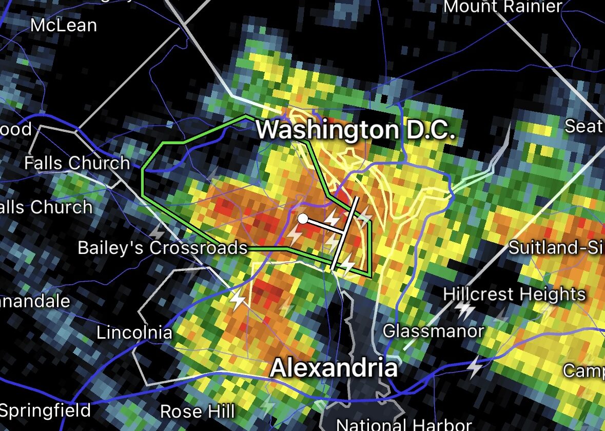
A Flood Watch has been issued for Arlington, as heavy rain and strong storms are possible starting late this afternoon.
The Flood Watch will take effect at 5 p.m. and run through early Tuesday morning. An “anomalous” amount of moisture in the atmosphere may lead to deluges that could cause flooding, forecasters say.
Meanwhile, severe storms and even an isolated tornado are possible tonight in Arlington and the D.C. area., the National Weather Service says.
More on the Flood Watch, below, from NWS.
155 PM EDT Mon Aug 14 2023
…FLOOD WATCH IN EFFECT FROM 5 PM EDT THIS AFTERNOON THROUGH LATE TONIGHT…
* WHAT…Flooding caused by excessive rainfall is possible.
* WHERE…Portions of DC, Maryland and northern Virginia, including the following areas: in DC, District of Columbia. In Maryland, Anne Arundel, Cecil, Central and Southeast Howard, Central and Southeast Montgomery, Northern Baltimore, Northwest Harford, Northwest Howard, Northwest Montgomery, Prince Georges, Southeast Harford and Southern Baltimore. In northern Virginia, Arlington/Falls Church/Alexandria, Eastern Loudoun and Fairfax.
* WHEN…From 5 PM EDT this afternoon through late tonight.
* IMPACTS…Excessive runoff may result in flooding of rivers, creeks, streams, and other low-lying and flood-prone locations.
* ADDITIONAL DETAILS…
– Anomalous moisture will overspread the region ahead of a cold front that will pass through tonight. Multiple rounds of showers and thunderstorms are possible this evening into the overnight. Rain rates over two inches per hour are possible. Urban areas and flood prone roadways will be of a particular concern.
– Please visit weather.gov/safety/flood for flood safety and preparedness informationPRECAUTIONARY/PREPAREDNESS ACTIONS…
You should monitor later forecasts and be alert for possible Flood Warnings. Those living in areas prone to flooding should be prepared to take action should flooding develop.
A Flood Watch for the potential for flash flooding has been issued for the DC and Baltimore Metros into northeast Maryland from 5 PM this evening until 2 AM Tuesday. Anomalous moisture will result in the potential for rain rates over 2" per hour. Latest: https://t.co/5RyZgpfrqr pic.twitter.com/Xvn0eUpci9
— NWS Baltimore-Washington (@NWS_BaltWash) August 14, 2023
Hot and humid air paired with an approaching warm front will result in thunderstorms later today. Some storms may become severe, with damaging winds, large hail, and an isolated tornado all possible threats. #DCwx #MDwx #VAwx #WVwx pic.twitter.com/tknwhJUh7o
— NWS Baltimore-Washington (@NWS_BaltWash) August 14, 2023
")
Get ready for some wild weather over the next day and a half.
First up are some storms tonight (Sunday) that are likely to be packing torrential rainfall. The heavy rain could cause flash flooding, prompting a Flood Watch to be issued this afternoon, taking effect at 8 p.m.
More from the National Weather Service:
239 PM EDT Sun Aug 6 2023
…FLOOD WATCH IN EFFECT FROM 8 PM THIS EVENING TO 2 AM EDT MONDAY…
* WHAT…Flash flooding caused by excessive rainfall is possible.
* WHERE…Portions of DC, Maryland and northern Virginia, including the following areas: in DC, District of Columbia. In Maryland, Anne Arundel, Central and Southeast Howard, Central and Southeast Montgomery, Prince Georges, Southeast Harford and Southern Baltimore. In northern Virginia, Arlington/Falls Church/Alexandria, Central and Southeast Prince William/Manassas/Manassas Park, Fairfax and Stafford.
* WHEN…From 8 PM this evening to 2 AM EDT Monday.
* IMPACTS…Excessive runoff may result in flooding of rivers, creeks, streams, and other low-lying and flood-prone locations.
* ADDITIONAL DETAILS…
– Heavy rainfall moving through with the potential for 1 to 2 inches of rainfall, locally higher, in a short period of time.
– Please visit www.weather.gov/safety/flood for flood safety and preparedness information
A Flood Watch is in effect from 8PM this evening to 2AM Monday. Showers and thunderstorms are expected to move through the watch area with the potential to produce 1-2 inches of rainfall in a short time frame. Locally higher precipitation totals are possible. #VAwx #DCwx #MDwx pic.twitter.com/T5k7cxvzzP
— NWS Baltimore-Washington (@NWS_BaltWash) August 6, 2023
Monday has the potential for even more active weather.
Arlington, D.C. and other parts of the region are under an “enhanced” risk of severe weather, according to a National Weather Service outlook. Severe winds are likely, according to NWS forecasters, noting the “seriousness” of the threat.
Meanwhile, large hail and even a tornado are also possible in the D.C. area.
")
According to NWS, this is the first time that D.C. has ever had a 45% or greater risk of severe winds on its next-day outlook.
The last instance of such a high probability of severe winds was the same-day outlook on Halloween day 2019.
Monday continues to look like a very busy & significant day across the region. We were upgraded to a level 3 out of 5 risk for severe storms overnight.
All hazards are on the table with even the potential for a couple tornadoes. Stay weather aware! #vawx #mdwx #dcwx #wvwx pic.twitter.com/mmTFL6ibHa
— Washingtonian Weather Geeks (@WashingtonianWx) August 6, 2023
The National Weather Service has placed the DC region under a level 3 out of 5 for severe potential late Monday, which means “numerous severe storms possible.” Damaging winds, hail, an isolated tornado are all possible. More details in our full forecast: https://t.co/zESWh64XVn pic.twitter.com/svM66OY4MX
— Capital Weather Gang (@capitalweather) August 6, 2023
")
The possibility of a succession of storms tonight packing heavy rain has prompted a Flood Watch from the National Weather Service.
The watch is in effect until 4 a.m. for Arlington, the District and much of the Washington region. Forecasters say flash flooding may occur during prolonged downpours.
More from NWS:
…FLOOD WATCH IN EFFECT UNTIL 4 AM EDT SUNDAY…
* WHAT…Flash flooding caused by excessive rainfall is possible. […]
* WHEN…Until 4 AM EDT Sunday.
* IMPACTS…Excessive runoff may result in flooding of rivers, creeks, streams, and other low-lying and flood-prone locations. Flooding may occur in poor drainage and urban areas.
* ADDITIONAL DETAILS…
– A seasonably moist airmass with ample moisture content ahead of an approaching frontal boundary will result in numerous showers and thunderstorms. These showers and thunderstorms will be capable of producing heavy rainfall with totals on the order of 1 to 3 inches with locally higher amounts where thunderstorms may train. These totals may result in flash flooding, particularly in urban areas and those that have observed recent heavy rainfall.
Another day, more heavy rain on the way. Be weather aware and stay alert for any warnings issued.
Be especially careful if you must be out as high water or flooding may be difficult to spot at night. As always, turn around, don’t drown. Be safe! https://t.co/Sbdj36kBWp
— VDOT Northern VA (@VaDOTNOVA) July 15, 2023

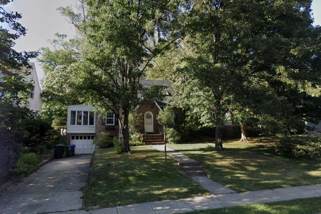
Arlington County is buying its fourth home for stormwater mitigation — this time in Westover, near the neighborhood’s main drag.
The Arlington County Board is set to approve the terms of the purchase, including a price tag of $1.5 million, on Saturday. The home is located at 5840 18th Street N., across the street from Cardinal Elementary School and the Westover Library branch.
This purchase is part of its voluntary property acquisition program targeting homes in the Spout Run watershed, which saw severe flooding during rain storms four years ago. Since agreeing to purchase its first home in March, the county has purchased a total of three — all in the Waverly Hills neighborhood.
The goal is to create “overland relief,” or a safe path for stormwater to flow to a stream or storm drain during large rain events. The county contends the existing stormwater systems and public space are not able to handle floods like those seen in 2019.
The newest acquisition is a stone’s throw from the stormwater detention vault at Cardinal Elementary, which was also a “community-driven project following the devastating losses and impacts to surrounding businesses and homes from the July, 2019 storm event,” according to the county.
The single-family home will be demolished, with viable parts of it salvaged for new purposes, if applicable.

")
Update at 1:20 p.m. on 7/9/23 — Arlington County and surrounding areas are now under a Severe Thunderstorm Watch in addition to the Flood Watch. Damaging wind and hail are possible from the storms, forecasters say.
A severe thunderstorm watch has been issued for parts of Delaware, District of Columbia, Maryland, New Jersey and Virginia until 8 PM EDT pic.twitter.com/HgwSdM3LD0
— NWS Severe Tstorm (@NWSSevereTstorm) July 9, 2023
Earlier: More slow-moving downpours are expected later in the day on Sunday, prompting a Flood Watch.
The new alert from the National Weather Service comes a day after one such storm drenched much of Arlington County, leading to a Flash Flood Warning as well as water rescues near Pentagon City.
The Flood Watch is in effect from noon to 10 p.m. Sunday for Arlington, D.C. and much of the region.
More from NWS:
…FLOOD WATCH IN EFFECT FROM SUNDAY AFTERNOON THROUGH SUNDAY EVENING…
* WHAT…Flash flooding caused by excessive rainfall is possible.
* WHERE…Portions of DC, Maryland and northern Virginia, including the following areas: in DC, District of Columbia. In Maryland, Anne Arundel, Calvert, Carroll, Cecil, Central and Southeast Howard, Central and Southeast Montgomery, Charles, Frederick MD, Northern Baltimore, Northwest Harford, Northwest Howard, Northwest Montgomery, Prince Georges, Southeast Harford, Southern Baltimore and St. Marys. In northern Virginia, Arlington/Falls Church/Alexandria, Central and Southeast Prince William/Manassas/Manassas Park, Eastern Loudoun, Fairfax, Northern Fauquier, Northwest Prince William, Southern Fauquier, Stafford and Western Loudoun.
* WHEN…From Sunday afternoon through Sunday evening.
* IMPACTS…Excessive runoff may result in flooding of rivers, creeks, streams, and other low-lying and flood-prone locations. Flooding may occur in poor drainage and urban areas.
* ADDITIONAL DETAILS…
– Slow moving thunderstorms capable of producing very heavy rainfall are expected across the watch area Sunday afternoon into Sunday evening. A widespread 1 to 2 inches of rainfall is expected across the watch area, with isolated totals in excess of 4 inches possible. This heavy rainfall may lead to rapid rises of water on creeks, streams, urban and poor drainage areas, and in other flood-prone locations.
– Please visit www.weather.gov/safety/flood for flood safety and preparedness information
A Flood Watch has been issued across the DC & Baltimore metros for Sunday afternoon through Sunday evening. Remember to stay weather aware and if you encounter high water on the road, 'Turn Around, Don't Drown'. #MDwx #VAwx #DCwx pic.twitter.com/6fcojV92A0
— NWS Baltimore-Washington (@NWS_BaltWash) July 8, 2023
⚠️A Flood Watch goes into effect tomorrow afternoon into tomorrow evening for much of the area. Slow moving thunderstorms may cause excessive rainfall of 1 to 2 inches, with some areas getting more than 4 inches. This may lead to flooding of rivers, creeks, streams, and low-lying… pic.twitter.com/3xy4CinrnC
— Washingtonian Weather Geeks (@WashingtonianWx) July 8, 2023
#WPC_MD 0673 affecting Northern Mid-Atlantic, #nywx #njwx #pawx #dewx #mdwx #dcwx #vawx #wvwx, https://t.co/YrpHmR22R0 pic.twitter.com/Cw49ccxYXJ
— NWS Weather Prediction Center (@NWSWPC) July 9, 2023
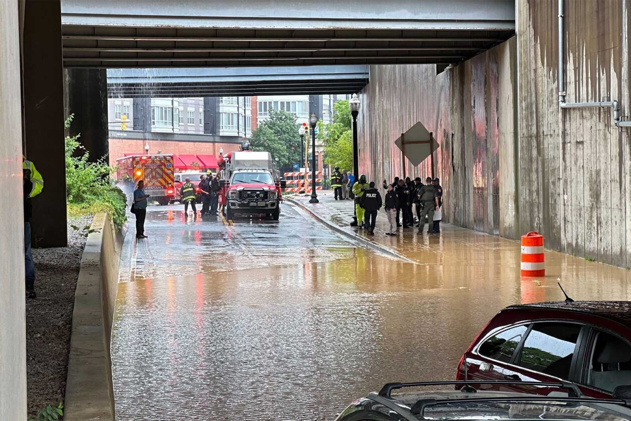
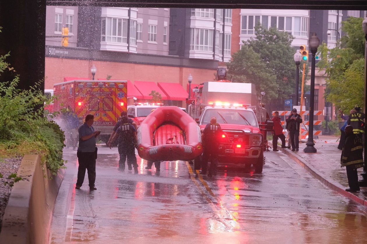
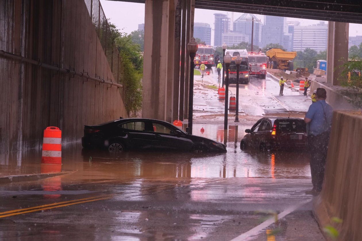
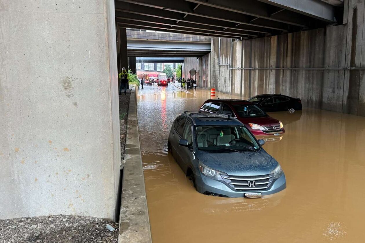
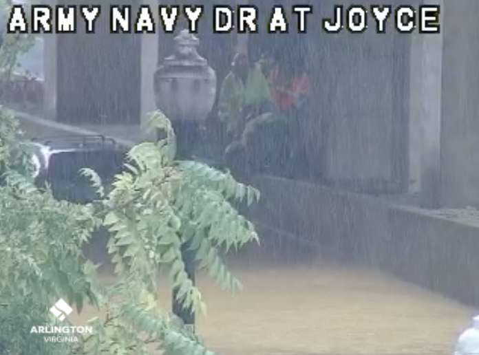
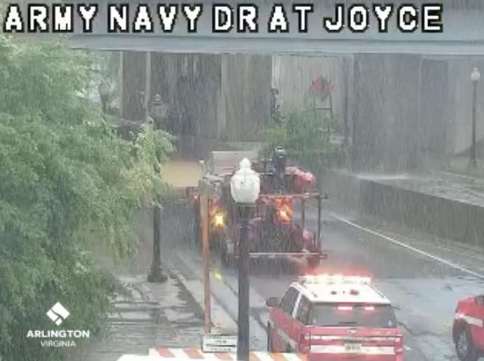
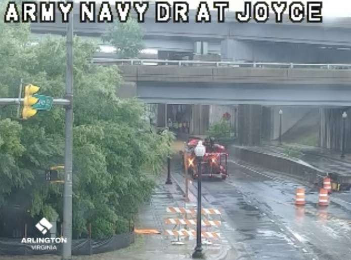
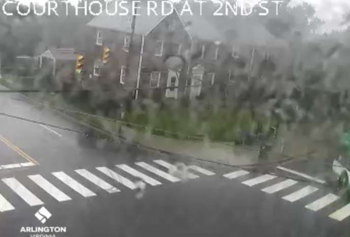
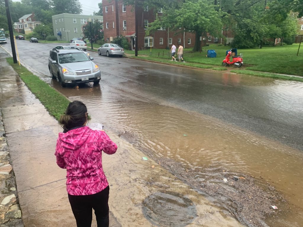
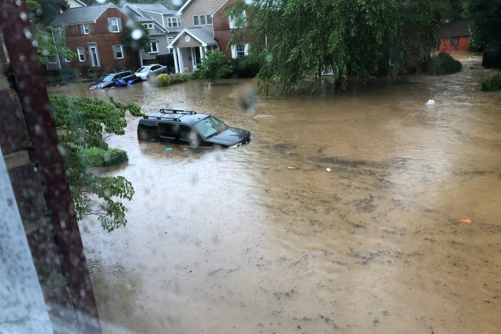
(Updated at 2:30 p.m.) Arlington County firefighters conducted water rescues in the Pentagon City area this afternoon amid torrential downpours.
Initial reports suggest that three cars were stuck in high water along S. Joyce Street between Army Navy Drive and Columbia Pike, and that multiple people — including an elderly person with disabilities — were stranded, either in their vehicles or on the concrete median.
Another report suggested that the water was so high that at least one of the vehicles was floating. On traffic cameras, water could be seen streaming down from the I-395 overpass above.
A large contingent of fire department resources, including boats, responded to the scene. As of 2 p.m., ACFD said it was clearing the scene after everyone was rescued and no one needed to go to the hospital.
Much of Arlington, including Pentagon City, is under a Flash Flood Warning due to slow-moving, heavy downpours. The flooded portion of S. Joyce Street remains closed.
Crews are on the scene of a Water Rescue Incident in the area of S. Joyce St and Army Navy Dr. Currently several vehicles are stranded in high water, crews are utilizing rescue boats to make access to those trapped in the vehicles. Avoid the area and expect delays. pic.twitter.com/A6PlIbQCep
— Arlington Fire & EMS (@ArlingtonVaFD) July 7, 2023
FINAL: All FD Units are in the process of clearing the scene, no patients were transported to the hospital as a result of the incident. Expect delays in the area to continue.
— Arlington Fire & EMS (@ArlingtonVaFD) July 7, 2023
NEW: S. Joyce under I-395 in Arlington right now. @ArlingtonVaFD water rescue assignment coming. Waiting for small boat to get 1 person out of a car. Arlington #traffic camera via @SafetyVid.@ARLnowDOTcom @WTOPtraffic @dougkammerer @capitalweather @StormHour #weather #traffic pic.twitter.com/G4iAsB5Esw
— Dave Statter (@STATter911) July 7, 2023
UPDATE: @ArlingtonVaFD made quick work of getting last person from a flooded car on S. Joyce under I-395. Looks like a construction crew helped. Possibly from @ArlingtonNatl expansion??? @ARLnowDOTcom @capitalweather @dougkammerer @StormHour #weather #traffic #safety #vatraffic pic.twitter.com/ZuJCbV1xOB
— Dave Statter (@STATter911) July 7, 2023
LOCATION: S Joyce St. / SB I-395
INCIDENT: Flooding
IMPACT: The entrance to SB I-395 from S Joyce St. is closed due to flooding. Seek alternate routes. pic.twitter.com/1bEt7qJF6s— Arlington Alert (@ArlingtonAlert) July 7, 2023
Update at 1:35 p.m. — A water rescue is underway in the Pentagon City area after high water stranded multiple people in vehicles.
Update at 1 p.m. — A Flash Flood Warning has been issued for a large portion of Arlington. A near-stationary storm is inundating south and central parts of the county, causing flooding.
From the National Weather Service:
The National Weather Service in Sterling Virginia has issued a
* Flash Flood Warning for… Southeastern Arlington County in northern Virginia…
* Until 400 PM EDT.
* At 1254 PM EDT, Doppler radar indicated thunderstorms producing heavy rain across the warned area. Between 1 and 2.5 inches of rain have fallen. Additional rainfall amounts of 1 to 2 inches are possible in the warned area. Flash flooding is ongoing or expected to begin shortly.
HAZARD…Flash flooding caused by thunderstorms.
SOURCE…Radar.
IMPACT…Flash flooding of small creeks and streams, urban areas, highways, streets and underpasses as well as other poor drainage and low-lying areas.* Some locations that will experience flash flooding include…
Arlington… Crystal City… Reagan National Airport… Ballston… Barcroft…
Flash Flood Warning including Arlington VA and Reagan National Airport VA until 4:00 PM EDT pic.twitter.com/lDgSTtaNFI
— NWS Baltimore-Washington (@NWS_BaltWash) July 7, 2023
Watch: We are under a flood warning in #Arlington. This is what one of the usual poor draining spots on I-395N across from the Pentagon looks like right now. @ARLnowDOTcom @SafetyVid @VaDOTNOVA @CordellTraffic @WTOPtraffic #safety #vatraffic #traffic #395cam pic.twitter.com/hrFWMtBtok
— Dave Statter (@STATter911) July 7, 2023
Earlier: Arlington and much of the D.C. area is now under a Flood Watch.
Slow-moving storms might dump lots of rain in short order this afternoon and evening, causing flooding, forecasters say.
More from the National Weather Service:
…FLOOD WATCH IN EFFECT UNTIL 8 PM EDT THIS EVENING…
* WHAT…Flash flooding caused by excessive rainfall is possible. […]
* WHEN…Until 8 PM EDT this evening.
* IMPACTS…Excessive runoff may result in flooding of rivers, creeks, streams, and other low-lying and flood-prone locations.
* ADDITIONAL DETAILS…
– A couple rounds of slow-moving showers and thunderstorms are likely this afternoon into this evening. A few inches of rain is possible in a short amount of time as a result, and may cause rapid rises of water on creeks, streams, urban and poor drainage areas, and in other flood-prone locations.
– Please visit weather.gov/safety/flood for flood safety and preparedness information.
Expect high temps in the upper 80s & low 90s with heat indices making it feel like 95-100 degrees. Scattered to numerous showers & t-storms are likely this afternoon, some of which could be locally gusty with isolated instances of flooding between 1-7pm. #MDwx #VAwx #Wvwx #DCwx pic.twitter.com/9ZJNne1apj
— NWS Baltimore-Washington (@NWS_BaltWash) July 7, 2023

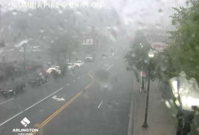
A slow-moving thunderstorm is hovering over northern and western portions of Arlington, prompting a Flash Flood Warning.
The storm is dropping copious amounts of rain, which could cause streams to overtop their banks and basements to flood. The warning is in effect until 6:30 p.m.
The Falls Church area is getting hit particularly hard by the downpour.
More from the National Weather Service:
The National Weather Service in Sterling Virginia has issued a
* Flash Flood Warning for… Western Arlington County in northern Virginia… Central Fairfax County in northern Virginia… The Northwestern City of Alexandria in northern Virginia… The City of Fairfax in northern Virginia… The City of Falls Church in northern Virginia…
* Until 630 PM EDT.
* At 325 PM EDT, Doppler radar indicated thunderstorms producing heavy rain across the warned area. Between 0.5 and 1.5 inches of rain have fallen. Additional rainfall amounts of 1 to 3 inches are possible in the warned area. Flash flooding is ongoing or expected to begin shortly.
HAZARD…Flash flooding caused by thunderstorms.
SOURCE…Radar.
IMPACT…Flash flooding of small creeks and streams, urban areas, highways, streets and underpasses as well as other poor drainage and low-lying areas.
A Flash Flood Warning has been issued for Fairfax, Falls Church and Arlington until 6:30pm.
⚠️ Do not cross flooded roads
👀 Watch for areas of high water
💡 Lights on with wipersReport flooded roads or downed trees to https://t.co/12wxgee8pi or 1-800-FOR-ROAD. https://t.co/mq7edyCf95
— VDOT Northern VA (@VaDOTNOVA) July 5, 2023
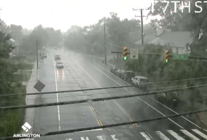
Radar loop: 330 pm…Very heavy rainfall continues slow across the DC and Baltimore metros! Some areas may see a quick inch or two depending on your location. If you encounter high water on the road, Turn Around Don’t Drown. #MDwx #VAwx #DCwx #WVwx pic.twitter.com/oyNhgn1QFO
— NWS Baltimore-Washington (@NWS_BaltWash) July 5, 2023
Radar is already showing that 2+ inches of rain has fallen across areas just to the outside of Falls Church.
Flooding is likely ongoing so please make sure to not drive though any flooded roadways. #vawx pic.twitter.com/fmqqVAHUU9
— Washingtonian Weather Geeks (@WashingtonianWx) July 5, 2023
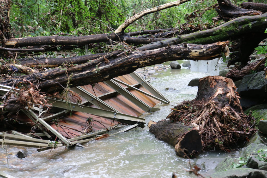
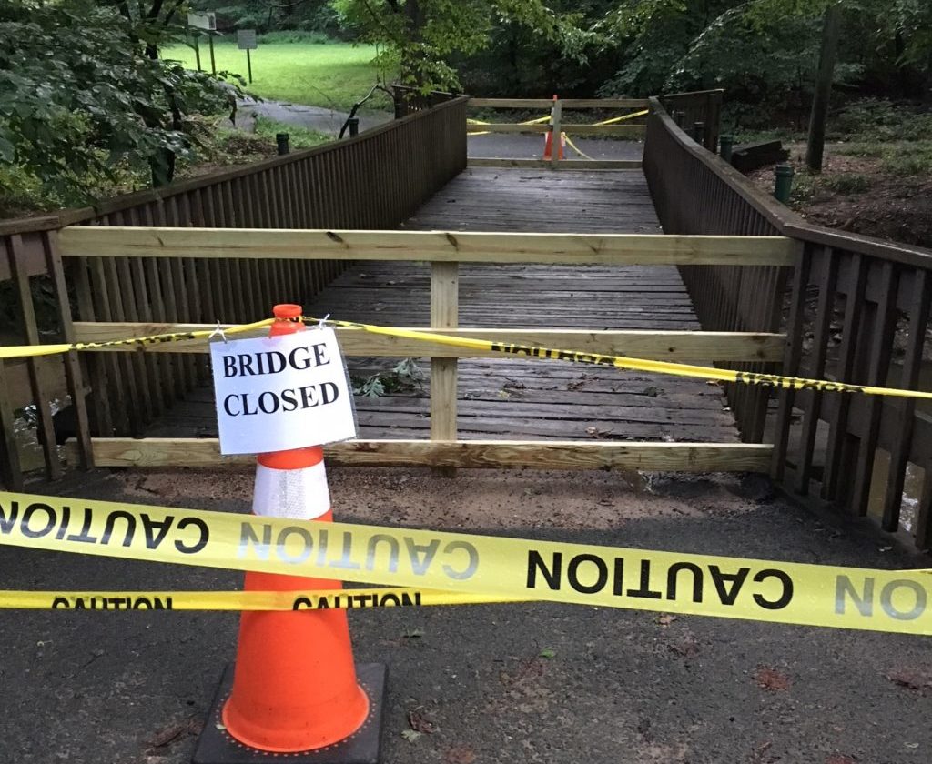
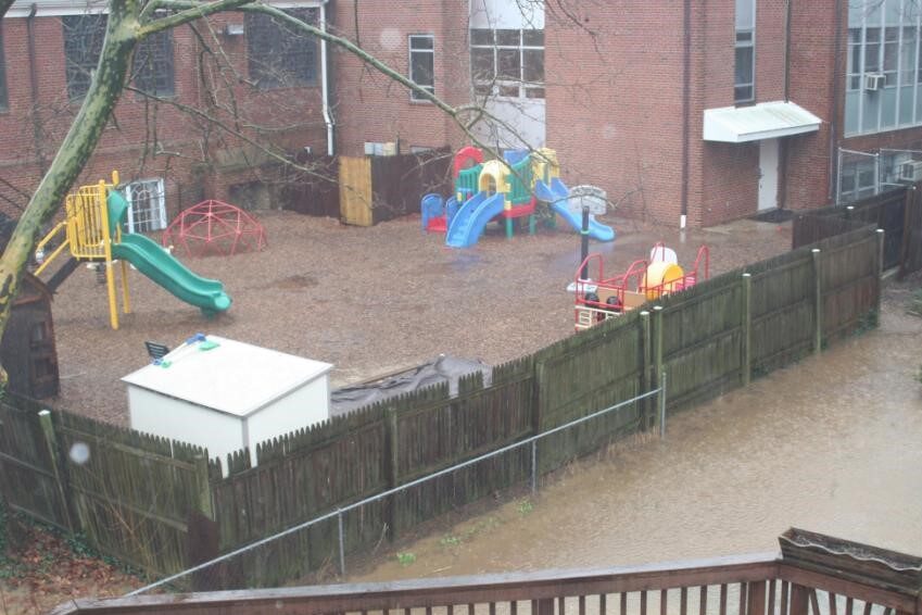
Arlington County is working on a replacement for the two bridges over Lubber Run destroyed in severe flash flooding four years ago.
The Arlington County Board is set to discuss a $360,000 construction contract for a new pedestrian bridge at its meeting this weekend.
Flash flooding in 2019 washed away six pedestrian bridges in Arlington, including two in Lubber Run Park and four in Glencarlyn Park. The overall damage to county property was estimated at $6 million at the time.
On Saturday, the Board will consider approving the new bridge in Lubber Run, in place of the two that were destroyed. The contract — of about $329,000 with a $33,000 contingency — is expected to go to Fairfax-based Bright Masonry.
A lower bidder — by just over $30,000 — was “deemed nonresponsive” by county staff, according to a report to the Board.
The project’s goal is to “design one new bridge in the most suitable location for enhancing accessibility around the park,” the staff report said.
One of the bridges in Glencarlyn Park that was washed away was replaced in February of last year.
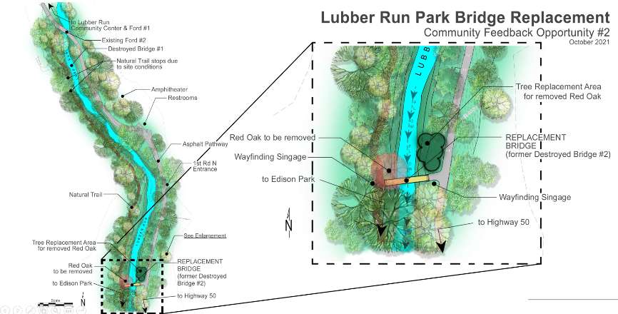
The proposed construction for Lubber Run involves building one new bridge in the southwest portion of the park to replace the previous two, as explained in the county’s project webpage.
“Through our community engagement and engineers’ analysis, we have found that this location will provide a significant, positive impact on park users and supports the community’s interest,” the webpage noted.
For parkgoers, the proposed bridge will provide access from Lubber Run to Edison Park, staff said. The bridge would also provide a connection between the southwest portion of the park and its east side.
Construction is estimated by staff to take around 12 months and seeks to minimize environmental harm.
“One tree, with exposed roots on the bank, will need to be removed. It already has a very low chance of survival due to its current condition,” the project webpage said. “We will plant healthy trees in the same general areas, which will better support our tree canopy in the long term.”
This spring, Arlington County began buying up properties in the Waverly Hills area to combat flooding.
Already, despite some concerns about how the program would work, three residents have agreed to sell their homes. The county will tear them down and replant the land so water has a place to flow during large rain storms.
All seven Arlington County Board candidates — six of whom are vying for the support of the local Democratic party this primary — say the county needs to change its land-use policies and get more people on board with adding stormwater infrastructure in their backyards, in order to make neighborhoods more resilient to a predicted increase in flooding.
“The July 2018 and 2019 floods in particular really drove this home for us — we had some real life-safety issues pertaining to flooding,” Susan Cunningham said in a forum hosted by nonprofit advocacy group EcoAction Arlington last week.
“[It] highlighted that, not only because of climate change but really because of lack of long-range planning, we have very outdated stormwater management systems that we don’t have a budget to improve,” she continued. “We do have a lot of catch up to do.”
Since the floods, Arlington County has taken steps to manage stormwater beyond buying homes for flood relief.
Starting next year, Arlington will fund its stormwater management plan with a stormwater utility fee. The county will charge property owners a rate based on how much of their property is covered in hard surfaces, like roofs and driveways. (Currently, it is funded by a tax based on property assessments.)
Other changes include new regulations requiring single-family home construction projects to retain more water and some $90 million in bond referenda from 2020 and 2022 for stormwater projects.
Developers of single-family homes report higher construction costs due to retention regulations. Bonds and the new stormwater utility fee, meanwhile, could spell higher taxes for residents.
So, in this race, some candidates say the county should examine how its own policies encourage flooding before requiring more of residents.
Cunningham and Natalie Roy, both of whom have opposed the recently adopted Missing Middle zoning changes, that starts with reducing the allowable buildable area that homes can occupy on a lot.
“This is something that we should’ve done 10 years ago and definitely something we should have done before approving the misguided [Missing Middle] plan,” Roy said.
Perennial independent candidate Audrey Clement said she would call for the repeal of Missing Middle, linking the new policy to tree loss and thus, increased flooding.
She said she would also end a practice among developers to subdivide lots to circumvent state environmental ordinances preventing construction near protected land along Arlington streams called “resource protection areas,” or RPAs.
“It was by this sleight of hand that the county permitted a tear-down McMansion in a North Arlington RPA in 2018 but also the destruction of a 100-foot state champion redwood on the same lot,” she said.
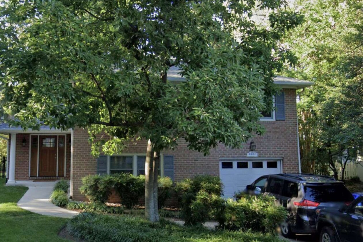
Arlington County is poised to purchase two additional homes for stormwater management in the Waverly Hills neighborhood.
The pair of homes are a few doors down from the first home it purchased last month on 18th Street N.
The county will pay $1 million for the home at 4423 18th Street N. and $1.3 million for the other at 4433 18th Street N., per county reports prepared for each sale contract. The Arlington County Board is set to review these contracts during its meeting on Saturday.
The two will be torn down for $350,000 apiece and the land will be replanted to create green spaces that will act as overland relief — essentially a safe pathway for water to flow during large flooding events, such as the floods of July 2019. Such flooding events have particularly impacted the Spout Run watershed, where the county is targeting its land acquisition efforts.
Neither home has a historic designation nor architectural significance but staff from the county’s Historic Preservation Program recommend that viable parts of the home be salvaged and photos taken of the interior and exterior for the program’s archives.
Sales are expected to be settled in about five months and the residents will have two months beyond that to move out.
Arlington County previously told residents of the Waverly Hills and Cherrydale neighborhoods it is considering several stormwater management strategies but voluntary property acquisition will be “necessary” for reducing flood risk.
At the time, it said it would first focus its efforts on the Waverly Hills neighborhood and touted benefits of selling to the county such as lower closing costs and peace of mind.