
Arlington County could soon acquire a Columbia Pike home as part of an effort to improve an intersection.
The Arlington County Board on Saturday is set to consider whether to make a $627,000 offer to the owner of 1802 Columbia Pike.
Acquiring the property would allow the county to realign the intersection of S. Rolfe Street and the Pike, making current plans to improve the crossing safer and more efficient, according to a county report.
A proposed resolution comes with a threat of the county forcibly claiming the home, which has been vacant since January 2021. If the landowner and her legal guardian were to refuse the county’s offer, county staff are seeking permission to exercise eminent domain to take the property and compensate its owner.
The resolution declares that acquiring the property is “a public necessity” for the sake of improving “public safety, convenience and welfare at said intersection.”
“The County has been in discussions with the Conservator regarding voluntary acquisition of the Property since January 2023,” the report says. “Discussions to date have been unsuccessful.”
For years, according to the report, the county has been in talks with residents of the Arlington View neighborhood about improving transportation access and safety issues. The only way out of the neighborhood is through three intersections on the Pike, and only one of these intersections has a traffic signal.
The county’s original plan for improving S. Rolfe Street and Columbia Pike calls for a split-phase traffic signal, which would allow pedestrian crossings only on the east side of the intersection. Acquiring this house would instead let the county build an additional crosswalk on the Pike, making the intersection less hazardous for foot traffic and reducing delays for motorists by about 30%.
“A more efficient single-signal design will create a safer, direct crossing of Columbia Pike for bikes, pedestrians, and vehicles on S. Rolfe Street,” the report says. “This will benefit all modes of travelers on both Columbia Pike and S. Rolfe Street, and will particularly improve access for residents of the Arlington View neighborhood.”
Changes to this intersection are part of the Columbia Pike Multimodal Street Improvements project, a $114 million initiative partially funded by the Virginia Department of Transportation.

Photo (top) via Google Maps

Traffic signal upgrades and more pedestrian-friendly crosswalks may be coming to several Langston Blvd intersections.
The Arlington County Board on Saturday is slated to consider a $1.5 million contract for improvements to the intersections of Langston Blvd at N. Adams Street, N. Cleveland Street and Spout Run Pkwy.
Traffic signals at these intersections currently hang from wires, a county report notes. Sidewalks are narrow, pedestrian crossings are long and curbs lack wheelchair-accessible ramps.
“The proposed sidewalks, ADA curb ramps, high-visibility crosswalks, and traffic signal upgrade will provide safe, accessible, and user-friendly intersections,” the report says.
Arlington County has been gradually replacing older, hanging traffic lights with those mounted on sturdier mast arms.
The contract with Ardent Company, LLC includes $1.3 million plus $200,000 as a contingency for change orders or increased quantities.
The county noted that it will keep surrounding communities informed about the project through a variety of channels.
“Staff plans to provide updates to the community and stakeholders a few weeks prior to construction via the existing email group list, the construction notification letter, the project webpage, and the social networking service known as NextDoor, as well as providing periodic updates during construction,” said the report. “Impacted properties were visited in person to discuss minimal impacts and will be updated as the project goes to construction.”
The initiative is part of the Langston Blvd Intelligent Transportation Systems Improvement project, which seeks to improve intersections along the road from East Falls Church to Rosslyn. Construction along Langston Blvd is anticipated to begin this spring, according to a county webpage.
The county is also pursuing ITS projects on Glebe Road, Washington Blvd and the Crystal City and Pentagon City corridor. All of these projects are funded through a grant from the Northern Virginia Transportation Authority.
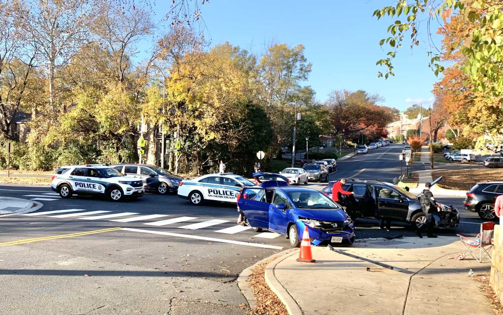
Relief is coming for a crash-prone intersection in front of the Lubber Run Community Center.
Arlington’s Dept. of Environmental Services says it is working on an expedited design and construction timeline to install a traffic signal at the intersection of N. Park Drive and N. George Mason Drive, near Barrett Elementary School, by the end of 2024.
Last month, the county told ARLnow it was working to get a signal installed within the next three years. The decision to shorten the timeline responds to an uptick in crashes there this year, DES told the Arlington Forest Civic Association in a meeting yesterday (Wednesday).
“The signal project is on target for completion by the end of next year,” Vision Zero Coordinator Christine Baker tells ARLnow. “We must procure all materials and finalize construction plans.”
With the installation date a year away, the county evaluated a trio of interim solutions while removing and trimming overgrown trees and shrubs in the median to improve sight distances.
At this troubled intersection, drivers on N. Park Drive have a two-way stop sign before traversing the four lanes of traffic on N. George Mason Drive.
Left turns and through traffic on N. Park Drive are the primary causes of crashes, says Baker.
After evaluating temporary stop signs, traffic signals or barriers to restrict certain traffic patterns, DES decided to keep exploring how to add barriers.
“We are also assessing the potential impacts to nearby intersections, such as Henderson, to ensure safe alternative routing,” Baker said.
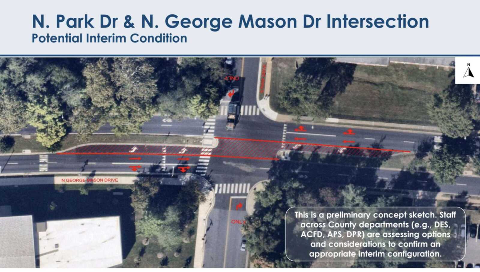
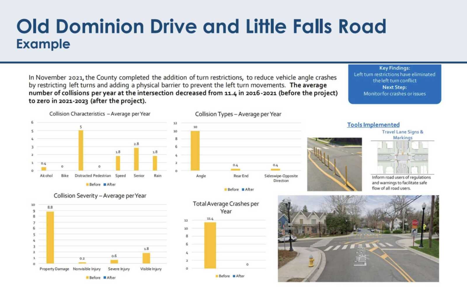
In its presentation last night, DES said turn restrictions are easy to install and effective. Crashes dropped at the intersection of Old Dominion Drive and Little Falls Road when similar turn restrictions were introduced there.
The restrictions on turning and going straight on N. Park Drive are set to be installed before the end of 2023. They will be removed when the traffic signals go in at the end of next year.
The updates are good news for residents, who have been asking for a solution soon, predicting pedestrians could get hurt. So far this year, the county has lowered speeds on the road near Barrett, repaved and restriped intersection — adding a “SLOW SCHOOL XING” message.
“Arlington Forest residents have been very concerned about safety at the intersection of George Mason Drive and North Park Drive for several years,” Arlington Forest Citizens Association President Esther Bowring said in a statement.
“That is why we are appreciative that Arlington County has now committed to not only expediting installation of a traffic signal at that location, but also to installing interim measures to improve pedestrian and traffic safety until the signal is installed,” she continued.
A traffic signal was recommended back in 2017, when traffic near the site was studied as part of plans for the new Lubber Run Community Center. Ultimately, the county moved forward with a Rectangular Rapid Flashing Beacon and pedestrian refuge.
Staff did pledge to conduct a traffic signal analysis after the community center was finished and new travel patterns settled.
(Updated at 12:50 p.m.) In the last four days, a crash-prone intersection near Lubber Run Community Center has logged nearly as many crashes.
Two crashes on Monday at the intersection of N. Park Drive and N. George Mason Drive — also near Barrett Elementary School — resulted in reported minor injuries. The other, this past Friday, caused only property damage. In two of the cases, a driver was cited, according to ACPD.
At this troubled intersection, drivers on N. Park Drive have a two-way stop sign before traversing the four lanes of traffic on N. George Mason Drive. There have been some changes intended to improve safety but it may take upwards of three years before some neighbors get what they have been pushing for: stop lights.
“We are looking to fully signalize the intersection in all four directions,” says Dept. of Environmental Services spokeswoman Claudia Pors. “The County is developing plans to install the signal within the next three years.”
The county also intends to make pedestrian ramps accessible to people with disabilities and make other changes that require construction. This means the project would have to use Capital Improvement Program funds.
“The precise combination of funds or programs has not been identified as of yet,” she said.
The pair of crashes bring the total number of reportable crashes — those resulting in injuries, death, or at least $1,500 of damage — to three this calendar year, ACPD says. The intersection has averaged three or four crashes annually since 2017.

Two of the crashes involved drivers on N. Park Drive trying to cross N. George Mason Drive or turn onto the road.
The preliminary investigation into a crash Monday morning, around 9:30 a.m., “indicates the a driver was traveling on N. Park Drive when they attempted to cross N. George Mason Drive resulting in a collision with another motorist who was traveling on N. George Mason Drive,” ACPD said.
That evening, police were dispatched to the report of a crash with injuries just before 5:30 p.m., ACPD later told ARLnow.
The investigation into Friday’s crash, shortly after 1 p.m., “indicates the driver of the striking vehicle was attempting to turn from N. Park Drive onto George Mason Drive when they stuck a vehicle traveling on George Mason Drive,” ACPD says.
Angle crashes — which comprise the largest share of crashes in Arlington — made up most if not all the crashes last year, according to a 2022 crash report. This intersection is one of nearly a dozen that saw upwards of five angle crashes last year, and only one other intersection saw six or more.
The recent crashes reignited calls from some neighbors to act more quickly to install a traffic light.
“We feel like the County is waiting for a serious injury before they do something here,” says neighbor John Broehm.
@ARLnowDOTcom @ArlingtonVaPD @ArlingtonVA first picture is from Friday, second picture is from just now. Can we please get a traffic light at N. Park and George Mason? Or do we need a child to get run down? pic.twitter.com/1RDEG6gPkM
— David (@Dhartogs) October 2, 2023
So far this year, the the county has lowered speeds on the road near Barrett, repaved and restriped intersection — adding a “SLOW SCHOOL XING” message, Pors said.
Responding to county-wide policy, speeds were reduced on parts of N. Park Drive near the school to 20 mph at all times. The speed limit on N. George Mason Drive in the area is 30 mph, reduced to 20 mph when a light near the community center is flashing.
Previously, in 2020, Rectangular Rapid Flashing Beacons were installed to give pedestrians a more “protected” window to cross at the N. Park Road intersection.
On a Thursday morning two weeks ago, there was a notable police presence at the intersection of N. Vermont Street and N. Carlin Springs Road.
Officers were watching for people blowing through a new stop sign, which was added in late May at the site of a crash where a driver struck a mother pushing her baby in a stroller.
This is the latest update for the intersection, which has been an “ongoing” location for investigations due to the high number of crashes there, according to Dept. of Environmental Services spokeswoman Katie O’Brien.
Now, instead of two stop signs, the intersection has four.
“We made several improvements in early 2021 and have been monitoring the intersection,” O’Brien said. “Due to recent crashes and an updated safety analysis, we analyzed the intersection for an all-way stop and found that it met the conditions. The signs were installed end of May and we are continuing to monitor the intersection.”
Previous improvements included installing “Cross Traffic Does Not Stop” signs on the existing stop signs and installing additional “Stop for Pedestrians in Crosswalk” neon warning flags and upgraded existing pedestrian warning signs, DES spokesman Peter Golkin said.
Everything, basically, but adding new stop signs.
Now, with the new all-way stop in place, DES is working with the Arlington County Police Department to educate drivers about the traffic change, she said.
“This includes in-person education from officers and variable messaging signage,” she said.
In the relatively short time that ARLnow was out there two weeks ago, three or four drivers who blew the stop sign were pulled over. Now two weeks into June, the variable messaging sign boards alerting drivers to the change are still up.
As part of the county’s goal to end serious and fatal crashes by 2030, known as Vision Zero, this intersection has been investigated as both a “hot spot” and as part of the county’s “high-injury network,” two designations for places with high rates of crashes.
Meanwhile, ACPD has its own list of dicey intersections, collectively known as “Traffic Accident Reduction Program” or TARP intersections, to determine where to send officers and other resources.
These “are generally higher frequency crash locations where enforcement is determined to be useful in reducing overall crash volume,” says ACPD spokeswoman Ashley Savage.
Some of these crash-prone intersections have pedestrians crossing multiple wide traffic lanes, or roads that merge with highways, along faded crosswalks. In others, cars have to navigate atypical traffic patterns.
The police department’s list of crash-prone “TARP” intersection includes the following. Read More
The Arlington County Board has approved a $2.8 million contract to upgrade traffic signals and streetscapes at three major intersections.
During its meeting on Saturday, the Board accepted plans to update Washington Blvd at N. Glebe Road in the Ballston area, Washington Blvd at N. Patrick Henry Drive in Westover, and S. Glebe Road at S. Eads Street near Crystal City.
The contract for the project stands at about $2.4 million with a contingency of nearly $375,000.
The county currently has a traffic signal infrastructure upgrades program in progress, with a goal of replacing all outdated traffic lights and signals, as explained on the project webpage.
For the three latest intersections, outdated traffic lights will be replaced and pedestrian safety improvements will be installed, the staff report said.
The project webpage notes that traffic signals at many Arlington intersections have “exceeded their intended service life” and that new traffic lights will “meet current Federal and County standards and specifications.”
So far there’s no word yet on when the intersection construction projects will begin. Updates will be provided via email lists, a construction letter, the project’s webpage and NextDoor for interested residents, according to the county.
(Updated at 12:20 p.m.) A troubled intersection near Lubber Run Community Center clocked another vehicle crash last week.
The collision at N. George Mason Drive and N. Park Drive last Tuesday happened as neighbors await the installation of street markings and, eventually, signage, alerting drivers to a lower speed limit of 20 mph in the area.
“A Porsche SUV gunned it through a busy intersection and collided with another SUV,” said Phillip Berenbroick, who saw the crash. “[It] happened right as kids and parents are rushing over to Barrett Elementary [School] for 9 a.m. school start.”
And that wasn’t all. While first responders were still on scene, an Audi SUV headed from the Arlington Forest neighborhood toward Ballston on Park Drive sped through the intersection and was pulled over by police, Berenbroick said. He noted that Rectangular Rapid Flashing Beacons stopping traffic and allowing pedestrians to cross N. Park Drive were flashing.
“It’s super dangerous for pedestrians when cars traveling eastbound on Park Drive out of Arlington Forest try to cross through the intersection and turn northbound on George Mason,” he said. “ACPD pulled the car over and let the driver off with a warning. It was a little surprising since the accident that police and EMTs were responding to was a result of the same type of dangerous driving.”
The collision reignited one neighbor’s push for a traffic signal there, particularly given the presence of Barrett Elementary one block away. Drivers tend to go fast on the four-lane expanse of N. George Mason Drive, leaving few windows for people on N. Park Drive trying to cross or turn left, including those going to and coming from the popular Lubber Run Community Center.
Arlington has a county-wide policy setting a permanent 20 mph speed limit on neighborhood streets within 600 feet of a school. Arlington County expects markings alerting drivers will cost $150,000 and will be added over the next 2-3 years.
Another crash and N. Park and N. George Mason, this morning, this time witnessed by kids walking to school and a child was in the car that was struck. Still debating a light @ArlingtonVA or waiting for kids to get injured? @ARLnowDOTcom pic.twitter.com/LKc4fn6BzX
— David (@Dhartogs) March 29, 2023
Rectangular Rapid Flashing Beacons, which give pedestrians are more “protected” window to cross the road, were installed at the N. Park Drive intersection in late 2020 as part of a transportation study related to the community center project.
Currently, the speed limit on N. George Mason Drive in the area is 30 mph, reduced to 25 mph when a light near the community center is flashing. Later this spring, speeds on the road will drop another 5 mph — to 20 mph — when lights are flashing, in response to a new county-wide policy.
As part of the updated school zone policy, the speed limit on parts of Park Drive near Barrett will be reduced to 20 mph at all times.
Also this spring, the intersection is expected to get new “SLOW SCHOOL XING” markings after it is repaved, according to Dept. of Environmental Services spokeswoman Claudia Pors.
“The Water Sewer Streets crew is putting together the schedule for what streets are getting repaved this season, so the timing of when the N. George Mason Drive and Park Drive [intersection gets] paved will depend on them,” said Pors.
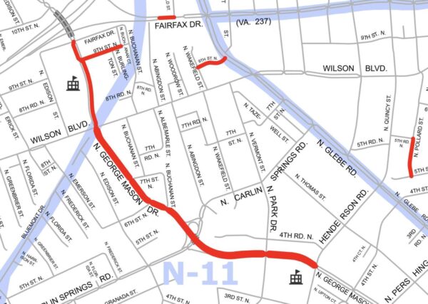
In all, there have been 23 crashes at George Mason sand Park since 2017, of which nine occurred in the two years the Lubber Run Community Center has been open, according to data from Arlington County Police Department. Last week’s crash does not register because it does not reporting criteria outlined in state code.
A South Arlington intersection that has seen two pedestrian-involved crashes this year, including one last week, is set to be updated to improve safety.
In the evening on Tuesday, March 14, an adult man was struck by a driver at the intersection of S. George Mason Drive and S. Four Mile Run Drive, causing bleeding from his head, per initial reports. His support dog ran off but was later returned, according to social media.
Planned renovation to this intersection are part of the South George Mason Drive Multimodal Transportation Study, which will bring changes along the major road from Arlington Blvd to the county border. The county and a resident involved in the process say complexities at this intersection have slowed down progress on this initiative, which was first expected to wrap up last fall.
“This project is part of the larger S. George Mason Drive project, but the county discovered fairly quickly that this intersection specifically was going to cause them to have to slow down the project to allow for additional study and design,” Douglas Park resident Jason Kaufman said.
A virtual meeting a few months behind schedule was scheduled to be held last night from 7-8:30 p.m., around the same time as the contentious Missing Middle vote, to discuss new designs for the proposed changes along S. George Mason Drive.
Concept plans from last summer proposed treatments including narrower roads, widened sidewalks and vegetation buffers between pedestrians and road users. One option included protected bike lanes while another mixed cyclists and drivers.
A county webpage for the project says staff have conducted an in-depth analysis of S. George Mason Drive where it intersects with S. Four Mile Run Drive, as well as with Columbia Pike, in preparing its plans.
The high-traffic intersection is a major artery for three neighborhoods that links road users to the City of Alexandria, I-395 and Shirlington. A service road, also called S. Four Mile Run Drive, runs parallel to the main road, basically creating a “double intersection.” The W&OD Trail runs parallel to and in between these two roads, crossing six lanes of traffic on S. George Mason Drive.
“Anyone that bikes, rides, drives, scoots or traverses through that intersection on a daily basis is aware of its challenges,” Kaufman said. “There are a number of conflict points that are dangerous. That intersection has one of the highest incidents of accidents in the county, including accidents that are considered ‘severe’ for the purposes of Vision Zero calculations, and it needs to be fixed.”
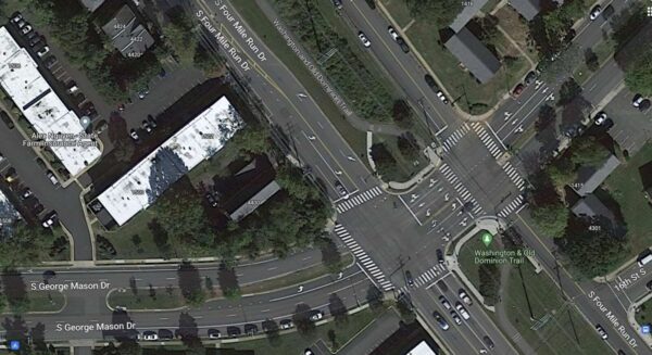
The county considers this intersection a “hot spot,” based on a review of crash data from 2019 and 2022. Between 2017 and 2019, there had been more than 15 vehicle crashes and at least two cyclist-involved crashes, per a 2020 report. The county’s crash dashboard lists two crashes with severe injuries, one in 2015 and another in 2017, and ARLnow reported on a hit-and-run with severe injuries in November 2021.
That’s in addition to last week’s crash.
@ArlingtonDES is working on designs at this very intersection because it's a known safety hazard
This is why we need them to work faster https://t.co/O7WXZJf0Ps
— eBike Gillian (@BikeGillian) March 14, 2023
For all road users, navigating the intersection requires hyper-vigilance, but people are rarely able to pay attention to “an overwhelming number of inputs,” says Douglas Park resident Kristin Francis.
A teenage girl on an electric scooter was seriously injured after colliding with a driver near Washington-Liberty High School earlier this afternoon.
Shortly after 1 p.m. on Tuesday, police were dispatched to Washington Blvd and N. Quincy Street, in the Virginia Square area, for the report of a crash with injury, a police spokeswoman told ARLnow.
“The preliminary investigation indicates a juvenile on an electric scooter was travelling southbound on N. Quincy Street when she proceeded through a red light and collided with a westbound travelling vehicle,” ACPD spokeswoman Alli Shorb said in a statement.
Initial reports identified the person who was hit as a 16-year-old girl. Police, firefighters and EMS personnel were all on the scene this afternoon, treating the teen and redirecting traffic away from the intersection.
Shorb said “the juvenile sustained serious, non-life threatening injuries and was transported to an area hospital.”
Though police said a scooter was involved, a blue e-bike could be seen lying on its side near the ambulance that carried the teen to the hospital.
The driver of the involved vehicle remained on scene and was not charged with any crime, based on the preliminary investigation, Shorb said, adding that the investigation is ongoing.
In a School Talk email to families, Principal Tony Hall identified the struck teen as a W-L student. He said EMS treated the teen on scene, resulting “in an ambulance and increased police presence near the school.”
“We are in contact with the family of the student,” he said. “There is no cause for concern to the greater W-L community at this time.”
Arlington County is nearing the end of project to overhaul of the intersection of Washington Blvd and 13th Street N., near Clarendon.
The redesigned intersection will have two lanes of travel in each direction, while the new 13th Street N. will make a “T” with the new Washington Blvd.
“The benefits of the wider sidewalks and utilities moved underground are a better pedestrian experience for current and future residents, and a more streamlined traffic pattern for vehicles,” Dept. of Environmental Services spokeswoman Claudia Pors said.
Previously, Washington Blvd surrounded a triangular patch of grass and dirt bordered by sidewalks — which county documents have described as a “diverter island” or “porkchop” — on all three sides. Drivers had to navigate around the island to either continue onto Washington Blvd or turn onto 13th Street N.
A busy stretch of Washington Boulevard in Clarendon has been put on the straight and narrow. Find out what happened to some quirky old reversible lanes and a traffic island, then meet a new "T" intersection. https://t.co/bNYpJUuKif pic.twitter.com/FNDXflDiuO
— Arlington Department of Environmental Services (@ArlingtonDES) January 10, 2023
When this stretch of Washington Blvd was first identified for changes in the 2014 Clarendon Sector Plan, it also had a reversible travel lane between 13th Street N. and Wilson Blvd.
This pattern appears to have been removed a few years before the construction on the new “T” intersection began in 2021, according to Google Maps street views from prior years.
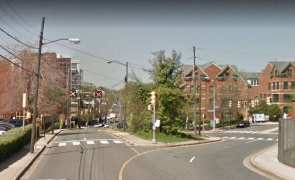
The Arlington County Board approved a contract to Sagres Construction Corporation to undertake the streetscape improvements and utility undergrounding in February 2021. Work started that spring and is expected to last 18-24 months.
“The project is still under construction and is expected to be completed this spring,” Pors said. “There’s still work to be done on signals, curb and gutter, milling and paving and landscaping.”
As part of the project, the work provided public open green space with seating and trees for a future park at the intersection, Pors said. The park will be at the northwest corner of the intersection, south of a reconfigured N. Johnson Street.
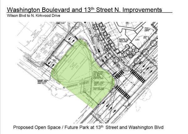
The project will also deliver wider sidewalks and improved pedestrian crossings, underground utilities, new traffic signals, street lights and street trees. It costs an estimated $6.4 million, from local commercial and industrial taxes earmarked for transportation and developer contributions.
The 2014 Clarendon Sector Plan called for these changes, which were then incorporated into the Red Top Cab properties redevelopment. The County Board approved this redevelopment in 2015, and the first phase was completed in the spring of 2021. Construction on the second phase began in January 2022.
The second phase, at the corner of Washington Blvd and 13th Street N., is comprised of a multifamily building with 269 homes.
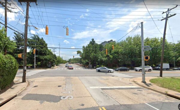
Upgraded traffic lights, roads and bus stops are expected at the intersection of S. Glebe Road and S. Arlington Ridge Road.
The Arlington County Board approved awarding a $1.6 million contract to the D.C. firm Fort Myer Construction Corporation for the project during its meeting on Saturday (July 16).
As part of a larger county program to upgrade “outdated” traffic lights, this project will change the span wire currently holding the traffic signals at the intersection to mast arms.
Other upgrades to be carried out include constructing curb ramps compliant with the Americans with Disabilities Act, adding high-visibility crosswalks and renovating bus stops at that location.
Currently, the intersection near the Four Mile Run Trail and the Alexandria border has narrow sidewalks, long pedestrian crossings and outdated bus stops. The project aims to “improve pedestrian safety and accessibility at the intersection,” according to the report.
The contract approved by the Board includes at 15% contingency on top of the construction firm’s $1.4 million bid, which came in lower than the county engineer’s construction cost estimate. Funding for this project was included in the adopted Capital Improvement Plan for fiscal years 2022 to 2024.
The project is expected to be completed by fall of next year, according to the county’s Traffic Signal Upgrade Project website.

