Arlington County is working on plans to make safety and accessibility upgrades a trio of local streets.
Some of the changes could include adding sidewalks where there are none, removing obstructions from existing sidewalks, and extending curbs — known as a “bump-out” — to make shorter pedestrian crossings.
Residents can learn more about this batch of “Neighborhood Complete Streets” projects in the Arlington Mill, Westover and Arlington Heights neighborhoods during a virtual meeting this coming Monday, May 8. t 7 p.m.
The projects were selected from more than 200 nominees by the Neighborhood Complete Streets Commission in February. The commission identifies and recommends for funding projects to improve the experience of cyclists and pedestrians — particularly those who need ramps or wider sidewalks to get around, such as people using wheelchairs or pushing strollers.
“Sidewalks free and clear of obstructions, streetlights, Americans with Disabilities Act-accessible curb ramps, safe space for bikes and appropriate street widths — these are all elements of a complete street,” per a county webpage.
Next week’s meeting will cover three projects selected after a competitive ranking process that considered gaps in sidewalks, heavy pedestrian use, speeding problems and surrounding socio-economic diversity.
On 8th Road S. between S. Dickerson and S. Emerson streets, in the Arlington Mill neighborhood, the county proposes building curb ramps accessible to people with disabilities and installing pedestrian bump-outs and other relevant signage and pavement markings.
“Existing conditions include complete sidewalks on both sides of the street and large intersections, which increase crossing distances for people walking,” per a project webpage. “Curb ramps are blocked by parked vehicles.”
The commission recommended 8th Road S. because of its crash history, traffic, high residential population, proximity to transit and location within a census tract that is lower income and more diverse.
On 14th Street N., in the Westover neighborhood, the county will install an accessible sidewalk for people walking between N. McKinley Road and the intersection with N. Ohio Street.
Arlington proposes installing sidewalk, curb and gutter, accessible curb ramps and new signage and pavement markings on the north side of the street.
The street won out over others because it is close to schools, transit and bike facilities but lacks consistent sidewalks, according to a project webpage.
Lastly, S. Irving Street near Thomas Jefferson Middle School is set to get an accessible, unobstructed sidewalk between 2nd and 6th Street S. The upgrades will connect to a planned new sidewalk between 6th and 7th Street S.
Currently, the sidewalk on both sides are obstructed by utility poles and streetlights, according to the county.
The street projects are in a preliminary design phase and, as such, could change. None have “undergone any detailed survey or design work” or have been approved for funding, according to the county.
More opportunities for community engagement will arise as the designs are further developed, the county says.
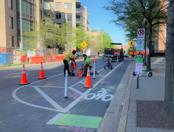
While road repaving season has kicked off in Arlington, crews are working on local roads for another reason.
They are installing traffic sensors in and marking some 4,500 parking spots in the Rosslyn-Ballston and Pentagon City-Crystal City corridors.
The spots and hardware are the foundation for a three-year, $5.4 million state-funded pilot project testing out a new way to manage parking availability and pricing, dubbed “performance parking,” which kicked off earlier this year.
Currently, parking is at a fixed rate and people have to find spots once they arrive at their destination, which can lead to double-parking or going somewhere else to, for instance, grab a meal.
Using existing meters and keeping the Parkmobile payment platform, the pilot intends to smooth out competition for convenient spots by directing people to cheaper options farther away. Prices would also vary based on time of day.
Arlington County will have a phone-friendly website with real-time availability and pricing data, which may also be accessible from some third-party apps. This information could help people plan where to park ahead of time, decreasing cruising time.
The pilot “is data-driven, using technology to better understand existing park utilization,” Melissa McMahon, the parking and curb space manager for Arlington County, told the Planning Commission this week. “We are actively managing parking supply to make parking more convenient and to reduce the negative impacts of hard-to-find parking.”
To get started, the county has to understand how people use on-street parking right now. Crews are delineating discrete spaces where, currently, it is a free-for-all between two signs, and installing one sensor per space.
Later this year, these wireless, battery-operated, in-ground sensors will start sensing when and for how long a car occupies a space. They will communicate that to “wireless gateways” located on traffic signal poles, which will relay that data to a central network server. That data is converted into a dashboard that county staff will use to make parking decisions.
Once it has enough “existing conditions” data this fall, the Dept. of Environmental Services will pick a range of prices, which it aims to bring to the Arlington County Board for approval this December. After that, for the next two years of the pilot, DES will request permission to change prices once per quarter to see the impact on driver behavior.
“This project does not create dynamically or fast-changing metered pricing,” McMahon said. “It won’t be uncertain on a day to day basis. If you’re going into a neighborhood routinely you’ll have a sense of where the lower price spots are and where the higher priced spots are.”
She said the goal is not to increase overall meter revenue, and blocks with lower rates may cancel out those with higher rates.

Public safety in Arlington County is poised to be increasingly automated and unmanned, with more traffic enforcement cameras and drones potentially coming soon.
The updates came during a work session on County Manager Mark Schwartz’s proposed budget, attended by County Board members and heads of public safety departments yesterday (Thursday).
Installing new speed cameras and adding more red-light cameras are part of the county’s Vision Zero initiative to reduce serious injury and fatal crashes, as well as a recommended way to reduce potentially adverse interactions between officers and civilians during traffic stops.
Cameras and drones could also help the Arlington County Police Department work more efficiently with fewer officers, as ACPD has had to scale back services amid ongoing challenges with recruiting and retaining officers.
More than a year ago, the County Board approved the installation of speed cameras in school and work areas to reduce speed-related crashes in these areas as part of the Vision Zero campaign to eliminate traffic fatalities and injuries. Now, according to Police Chief Andy Penn, a contract with a speed camera vendor could be ready this spring.
Last fall, the county told ARLnow that there would be more signs of progress, including camera installation and community messaging, once a contract is finalized this spring. Penn told the County Board yesterday that a request for proposal for both speed cameras and more red-light cameras will close next week.
“My hope is that we’ll have a contract for both of those in the next couple of months,” Penn said.
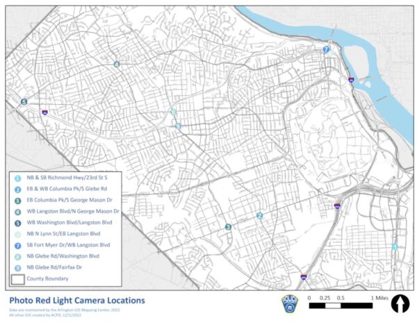
Meanwhile, the police department is working with the Virginia Dept. of Transportation to expand locations with red-light cameras, according to Penn.
“We’re almost at the finish line with VDOT on the PhotoRED expansions, there’s a couple intersections… we should be there soon,” he said.
There are nine intersections that currently use PhotoRED cameras, according to the county’s website. These intersections are located along major corridors including Columbia Pike, Route 1, Glebe Road and Langston Blvd.
Arlington is also considering deploying drones, which could be a safety tool for both police and fire departments. Penn and Fire Chief Dave Povlitz told the Board they are focused on improving employee safety and wellbeing, which could bolster staffing levels.
“While we’re on equipment, drones? Are we thinking about drones?” asked Board Vice-Chair Libby Garvey. “It’d be a lot safer to send a drone in than a person into a burning building.”
After working with other jurisdictions in the region and conducting a survey, a comprehensive proposal on drones could be ready for Board review in “the next couple of months,” according to County Manager Mark Schwartz.
“They are fantastic additions to any fleet,” he said. “We absolutely would, in many cases, prefer — not just for fire but police and also for our building inspections — to have the ability to have drones.”
Police may already be using drones locally in some cases. One could be seen flying near the former Key Bridge Marriott in Rosslyn this morning as part of a large public safety agency presence at the aging building, which the county condemned amid the continued presence of squatters.
Two hurdles to greater drone use could be privacy and flight regulations governing drones in the region, Schwartz said.
“We want to make sure we address the privacy concerns, which I think have been successfully handled in other jurisdictions,” he said.
Unmanned aircraft flights, including drones, are heavily restricted within a 30-mile radius of Reagan National Airport, according to rules the Federal Aviation Administration put in place after 9/11. Drones need FAA authorization and have to operate under certain restrictions.
A South Arlington intersection that has seen two pedestrian-involved crashes this year, including one last week, is set to be updated to improve safety.
In the evening on Tuesday, March 14, an adult man was struck by a driver at the intersection of S. George Mason Drive and S. Four Mile Run Drive, causing bleeding from his head, per initial reports. His support dog ran off but was later returned, according to social media.
Planned renovation to this intersection are part of the South George Mason Drive Multimodal Transportation Study, which will bring changes along the major road from Arlington Blvd to the county border. The county and a resident involved in the process say complexities at this intersection have slowed down progress on this initiative, which was first expected to wrap up last fall.
“This project is part of the larger S. George Mason Drive project, but the county discovered fairly quickly that this intersection specifically was going to cause them to have to slow down the project to allow for additional study and design,” Douglas Park resident Jason Kaufman said.
A virtual meeting a few months behind schedule was scheduled to be held last night from 7-8:30 p.m., around the same time as the contentious Missing Middle vote, to discuss new designs for the proposed changes along S. George Mason Drive.
Concept plans from last summer proposed treatments including narrower roads, widened sidewalks and vegetation buffers between pedestrians and road users. One option included protected bike lanes while another mixed cyclists and drivers.
A county webpage for the project says staff have conducted an in-depth analysis of S. George Mason Drive where it intersects with S. Four Mile Run Drive, as well as with Columbia Pike, in preparing its plans.
The high-traffic intersection is a major artery for three neighborhoods that links road users to the City of Alexandria, I-395 and Shirlington. A service road, also called S. Four Mile Run Drive, runs parallel to the main road, basically creating a “double intersection.” The W&OD Trail runs parallel to and in between these two roads, crossing six lanes of traffic on S. George Mason Drive.
“Anyone that bikes, rides, drives, scoots or traverses through that intersection on a daily basis is aware of its challenges,” Kaufman said. “There are a number of conflict points that are dangerous. That intersection has one of the highest incidents of accidents in the county, including accidents that are considered ‘severe’ for the purposes of Vision Zero calculations, and it needs to be fixed.”
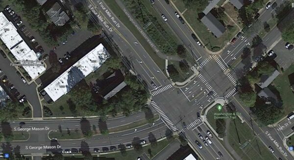
The county considers this intersection a “hot spot,” based on a review of crash data from 2019 and 2022. Between 2017 and 2019, there had been more than 15 vehicle crashes and at least two cyclist-involved crashes, per a 2020 report. The county’s crash dashboard lists two crashes with severe injuries, one in 2015 and another in 2017, and ARLnow reported on a hit-and-run with severe injuries in November 2021.
That’s in addition to last week’s crash.
@ArlingtonDES is working on designs at this very intersection because it's a known safety hazard
This is why we need them to work faster https://t.co/O7WXZJf0Ps
— eBike Gillian (@BikeGillian) March 14, 2023
For all road users, navigating the intersection requires hyper-vigilance, but people are rarely able to pay attention to “an overwhelming number of inputs,” says Douglas Park resident Kristin Francis.
More signs preventing right turns at red lights are going up around Arlington County to reduce crashes.
They were added to long stretches of major arterial streets, including Columbia Pike and Wilson Blvd. The county has concurrently reprogrammed walk signals to give pedestrians a head start crossing the street.
These changes are being made to eliminate crashes that are fatal or result in serious injuries, the aim of its two-year-old traffic safety initiative known as Vision Zero.
“This is a win for pedestrian safety benefit,” said Chris Slatt, a member of Sustainable Mobility for Arlington, which has advocated for more of no-turn-on-red signs in areas with many pedestrians. “You would want to be safe to walk and not have to worry about driving through crosswalk.”
Some drivers have anecdotally reported congestion and longer idling times to ARLnow.
“Seems like these signs cause a lot of cars to sit and idle at intersections longer than they used to,” notes one tipster. “They also generally gum up traffic.”
County documents note there have been safety benefits seen in areas with high pedestrian volumes. Additionally, a focus group of elderly adults appreciated the red light restrictions.
The county’s view is that any reasonable trade-off is worth it.
“Although traffic may slightly increase at times due these safety interventions, the trade-off is a safer environment for our most vulnerable users — pedestrians and bicyclists,” Dept. of Environmental Services spokeswoman Katie O’Brien said.
During Vision Zero’s second year, per a report, the county has been adding no turn on red signs on:
- Columbia Pike from the county line to Washington Blvd
- Fairfax Drive from N. Glebe Road to N. Kirkwood Dr
- Clarendon Blvd from N. Highland Street to Ft. Myer Drive and Wilson Blvd
- Wilson Blvd from N. Glebe Road to Fort Myer Drive
Year 2 of Arlington’s Vision Zero plan wraps up this spring.
The county says it has also grown the number of signalized intersections with a 3-7 second head start for pedestrians from 31 to 77 during Year 2. Studies show this change can reduce pedestrian-vehicle collisions by up to 60%.
As of March 2022, the county had no-turn-on-red signs at 147 approaches — each point of an intersection — after adding signs at 35 approaches in Year 1 of Vision Zero, per a May report.
Priority intersections for these changes include those with many pedestrians and bicyclists, restricted sight distance and a history of turn-related crashes, according to a “Vision Zero toolkit” of traffic safety treatments.
Arlington joins other states and municipalities, including D.C., phasing out the right-on-red at busy intersections. A number of studies have shown right on red decreases safety and restrictions improve safety for pedestrians and cyclists.
"Washington, D.C., will end most right-on-red turns by 2025. Already, the state of Hawaii has prohibited them on a tourist-dense stretch of road in Honolulu. The city of Berkeley in California is considering banning right on red at all intersections." https://t.co/zF0etmTtTr
— The War on Cars (@TheWarOnCars) March 10, 2023
Right on red was legalized 50 years ago to prevent idling and save gas during an oil embargo proclaimed by oil-exporting Arab countries, according to the county. The Energy Policy and Conservation Act of 1975 required states to allow right turns on red to receive certain federal funds.
“Unfortunately, the country has been experiencing the trade-offs of right on red turns ever since,” the county said in the Vision Zero toolkit.
A high-traffic intersection one block north of Columbia Pike could get some safety upgrades, including a traffic signal.
Arlington County is embarking on a project to develop plans to upgrade the intersection of S. Glebe Road and 9th Street S., located between the Alcova Heights and Arlington Heights neighborhoods.
In addition to replacing a rapid-flash beacon with a traffic signal, the county says changes, in collaboration with the Virginia Dept. of Transportation, could include extending the curbs, updating the crosswalks and refuge medians, and fixing deteriorating ramps that do not comply with the Americans with Disabilities Act.
The forthcoming project responds to community feedback, a 2022 safety audit of Glebe Road — a VDOT-maintained artery — and a 2020 analysis of “crash hot spots,” according to a county webpage. The latter two reports include data, photos and community comments describing unsafe conditions for pedestrians, cyclists, transit users and drivers.
“Glebe Road from 14th Street N. to Columbia Pike is part of Arlington County’s High Injury Network,” the county says. “These corridors experience high concentrations of critical crashes compared to other corridors in Arlington.”
Per the safety audit, the intersection saw two pedestrian crashes and five left-turn vehicle crashes between January 2018 and February 2021. It also found that many people drive over the speed limit by at least 5 mph between 8th Street S. and 9th Street S., going an average of 38 mph.
“Community feedback received as part of the Vision Zero Action Plan development identified Glebe Road and 9th Street S. as an unsafe crossing,” the county said.
Arlington is working toward eliminating traffic-related serious injuries and deaths by 2030 as part of its initiative known as Vision Zero. Transportation advocates and the Arlington County Board called for swift action to realize plan goals and make roads safer after a rash of crashes involving pedestrians last year.
Some residents heralded the project on Twitter as sorely needed and a long time in coming.
Back in 2018, cyclists who participated in a “protest ride” to advocate for better cycling conditions, called specifically for improvements to 9th Street S., which is part of the Columbia Pike Bike Boulevards, a bicycle route parallel to the Pike.
https://t.co/vYN9QhqKRZ pic.twitter.com/dCgqJnQT39
— Chris Slatt (@alongthepike) March 8, 2023
https://twitter.com/ARLINGTONAF/status/1633545704135172096
This spring, there will be a public engagement opportunity in which the county will solicit feedback on existing conditions, including site constraints such as utility poles that block parts of the sidewalk.
County staff are preparing engagement materials, and “when that’s ready, the engagement will open,” Dept. of Environmental Services spokeswoman Claudia Pors said.
The engagement will first ask people to share how they currently use these streets as well as any ideas or concerns they have.
“This input will be used to refine to goals and develop concept options,” the webpage says.
This spring and summer, county staff will again request feedback on a concept plan, which will be incorporated into a final design plan that the county anticipates can be prepared this fall.
Arlington County has completed, started or has planned other transportation upgrades along Glebe Road, per the 2022 audit, including new or re-programmed traffic signals and new ramps.
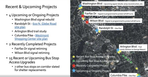
The West Glebe Road bridge partially reopened yesterday, though pedestrian and bicycle traffic will have to wait to make use of the span over Four Mile Run.
The bridge had severely deteriorated, requiring partial closures over the years until the bridge was fully closed last summer.
Work then began to replace the deteriorated roadway substructure, while reusing existing piers to shorten the construction time and keep costs down, according to Arlington County.
The bridge partially reopened yesterday (Wednesday) with one lane open in each direction.
According to the county website:
As of March 8, 2023, the West Glebe Road bridge is open to motor vehicle traffic, with one lane open in each direction. Pedestrian and bike traffic will continue to detour on the temporary bridge to the east of the main bridge.
The bridge is expected to fully open in summer of 2023, after completion of work on parapets, substructure, and streetlights.
The county says the next phase of construction will see the bike lane, curb and sidewalk put into place.
The Four Mile Run Trail underpass on the north end of the bridge remains closed until reconstruction is completed.
Some breaking news on the West Glebe Bridge: pic.twitter.com/QQV38teGd2
— Justin Wilson (@justindotnet) March 9, 2023
(Updated at 11 a.m.) Arlington County is suing three residents and the Ballston-Virginia Square Civic Association over their attempt to stop buses from being parked near their homes.
The county charges that they used the Board of Zoning Appeals (BZA) process improperly to prevent the approval of a special use permit to allow 29 Arlington Transit (ART) buses to park on a county lot across the street from Washington-Liberty High School while a new ART bus facility is built in Green Valley.
The county says the BZA doesn’t have the authority to hear their case and, without an allegation of harm or potential harm not shared by their neighbors, the residents are not “aggrieved parties” and are thus improperly using the appeal process to block the county’s plans.
“The Applicants sought their appeals simply as a way to undermine the County Board’s authority and to prevent the County Board from approving a special exception use permit for the Subject Property, thereby weaponizing the stay required by Va. Code… and in effect usurping the legislative power of the County Board,” per the lawsuit.
But the residents, who live in two of the five homes on a ridge overlooking the parking lot, argue the county is suing them preemptively while running afoul of its own zoning ordinances. Further, they say the bus activity will seriously undercut their property values and quality of life and suggest the county should buy their homes.
The lawsuit says that one resident’s BZA appeal asked the body to “compel the County Board to purchase some of the Applicant’s properties.”
Both the county and the residents declined to comment to ARLnow on the ongoing lawsuit, set for a hearing in Arlington County Circuit Court later this month.
Arlington County bought the largely industrial site, also known as the Buck site after its previous owner, in 2015 for $30 million to serve a variety of needs.
Arlington Public Schools parked “white fleet” vans there and, as part of an agreement in 2022, the county moved the vans from a part of the site zoned for “light industrial” uses to another zoned for “mixed use,” and park the ART buses in the “light industrial” zone.
This violates an ordinance, a site plan and a deed of covenant governing the property dating to 1985, the civic association alleged in a letter to the County Board in May 2022. The letter says county staff made procedural and substantive missteps that should have invalidated the county’s special use permit application and subsequent action to abandon the right-of-way of a former street on the site.
The civic association alleges that this change came after the county already violated zoning ordinances related to parking and landscaping by conducting motorcycle maneuvering training and storing dumpsters in parking areas while, in landscaped areas, letting trees die and English ivy take over.
As for the new use, they say the noise is unbearable, emissions from the Compressed Natural Gas-powered buses are “toxic,” and vibrations shake nearby homes — leading to their properties becoming “unmarketable” and “uninhabitable.” The BVSCA posted the following video of an ART parking exercise on the site last year.
Residents say the county’s real estate office proposed reducing their property assessments by up to $190,000 and heard from four realtors who say they’d be reluctant to list these properties.
(Updated at 3:15 p.m.) An emerging local group is looking to corral the “Wild West” of e-scooter parking in Arlington County.
The embryonic organization, which is calling itself “Purge,” will employ drivers to pile micro-mobility devices parked illegally on private property into vans and — essentially — hold them hostage until the operators of the offending devices pay a $50 invoice fee for their release.
“This is a huge opportunity and issue,” says Will, the founder, who requested to have his last name withheld until the official company launch. “We don’t want to interact with them at all: just pay it and it’ll go back on the street. They’re going to hate that but there’s nothing to say we can’t do that.”
If the business model sounds familiar, that’s because it is quite similar to how controversial Ballston-based trespass towing company Advanced Towing operates. Advanced, however, works within an established state and local regulatory framework, frequent accusations of skirting such laws by those on the undesirable end of their tows notwithstanding.
Arlington County has authorized a number of operators, including Bird, Spin and Lime, to operate some 350 e-bikes and 2,000 e-scooters within its borders. Some locals have long complained that scooter parking blocks pedestrian and, at times, vehicle traffic.
In response, the county has rolled out “corrals” to give people more legal options for parking their scooters, paid for by the cost for operators to do business in Arlington.
“Arlington has made decent strides with the corrals, but they’re a suggestion no one has forced them to operate better or develop incentivization for users to engage in better rider behavior,” Will says.
Billing operators could, he theorizes.
Something similar is happening in San Diego, where a duo impounds scooters in a lot using a flatbed truck. Scooter operators fought back with a lawsuit and later, cease-and-desist letters to private property owners using the impound service. The city has since filed its own lawsuit alleging the way these scooters are parked is a safety hazard.
“We’re trying to offer a balance here. The outcomes are they’re either forced to incentivize better behavior, or the [county] is forced to contract with us,” Will says. “We are working with local attorneys — there’s nothing in place to force them to operate legally. We think we have a low-tech solution that doesn’t require a huge investment.”
When it launches, Purge will only service private property. It doesn’t need impound authorization from private property owners, Will claims, while adding that several local private property managers, including some hotels and apartment buildings, have given the company the thumbs-up to haul away scooters.
Scooters abandoned in public right-of-way, however, could remain tripping hazards and nuisances — for now. Purge would skip mis-parked scooters on public property, at least initially.
For recourse, people can report mis-parked or abandoned devices via Arlington County’s Report a Problem tool, or via the helplines the companies operate. Operators are required to remove improperly parked devices within two hours of a report of mis-parking, according to the county’s website.
The other option is to just step around them, which can be dangerous for people who are blind or in a wheelchair or have another disability that impairs their mobility.
“Mobility only works if it works for everyone,” says Will, pointing out that these companies have raised hundreds of millions and — in some cases — billions of dollars, but in his view have not sufficiently invested in ways to incentivize proper parking.
(Updated 3:40 p.m.) Work is ramping up on a new Arlington County bus maintenance building and parking garage in Green Valley.
Crews are set to wrap up laying the foundation for the Arlington Transit (ART) Operations and Maintenance Facility at the end of this month, says Dept. of Environmental Services spokeswoman Alyson Jordan Tomaszewski.
“The facility will perform regular preventive bus maintenance, repairs and other unscheduled maintenance work,” per a project webpage. “It also will include administration and operations functions and parking for buses and staff.”
Then, passers-by may notice a crawler crane on site, which will be used to install steel columns. That work is set to last until sometime in March, according to the project webpage.
Meanwhile, work on the foundation of the parking garage is planned to start at the end of January, she says.
Construction began in June 2022 and is expected to be completed in the fall of 2024.
“We have experienced both weather and supply chain delays with the ART Operations and Maintenance Facility,” she said. “However, we are still on track for completion in fall 2024. To mitigate the supply chain issue, we are expediting material approval and procurement as best we can.”
ICYMI: Foundation and other infrastructure taking shape at the ART Operations and Maintenance Facility site along Shirlington Road. Work proceeds through next year. https://t.co/d6DdG1ZpQD pic.twitter.com/WNFKcZ0Oz8
— Arlington Department of Environmental Services (@ArlingtonDES) January 16, 2023
The Green Valley Civic Association welcomes the new facility.
“The county used to park about 60 ART buses right in Jennie Dean Park, next to the basketball court,” Robin Stombler, community-affairs chair of the civic association, tells ARLnow. “Moving the buses into a new operations facility adjacent to I-395 is not only a welcome change, but should mitigate noise and light disturbances on the residential community.”
Still, the civic association has some lingering concerns.
“We were vocal on the need for improved environmental conditions. This meant a state-of-the-art facility outfitted for a future electric bus fleet, better stormwater management and bioretention ponds, and lit signage that does not face the residential part of Green Valley,” Stombler said.
“The new county bus campus will house a staff-only, multi-story parking garage,” she continued. “We need some creative thinking to make sure this amenity is shared with the rest of the neighborhood.”
Next door, the general manager of the Cubesmart storage facility tells ARLnow that the county has “been very sensitive to the fact that we have traffic flowing in and out of there and has done great job keeping the road clean.”
The Cubesmart opened a second facility near the construction site back in March 2021. Between the original building, now “The Annex,” and the new building, there are nearly 2,400 storage units, she said.
This construction project follows on the heels of other recently completed ones in the Green Valley neighborhood, aimed at realizing a community vision of an arts and industry hub. The new John Robinson, Jr. Town Square, with a towering sculpture, as well as the renovated Jennie Dean Park opened with great fanfare this spring.
The County Board approved the purchase of the three parcels in Green Valley to build the ART facilities back in 2018.
“This project is essential for ART’s long-term sustainability and will address the current and future needs for parking, operations and maintenance of the County’s growing ART bus fleet,” according to the project webpage. “ART has significantly increased its number of routes and hours of service during the past 10 years and plans to continue growing during the next 20 years, supported by a fleet of more than 100 buses.”
The total cost to buy the land, plan and design the project and construct it is $81.2 million.
Work hours are 7 a.m. to 9 p.m. on Monday through Friday, with some weekend work occurring between 10 a.m. and 9 p.m.
This article was updated to add comments from the Green Valley Civic Association.
Arlington County is nearing the end of project to overhaul of the intersection of Washington Blvd and 13th Street N., near Clarendon.
The redesigned intersection will have two lanes of travel in each direction, while the new 13th Street N. will make a “T” with the new Washington Blvd.
“The benefits of the wider sidewalks and utilities moved underground are a better pedestrian experience for current and future residents, and a more streamlined traffic pattern for vehicles,” Dept. of Environmental Services spokeswoman Claudia Pors said.
Previously, Washington Blvd surrounded a triangular patch of grass and dirt bordered by sidewalks — which county documents have described as a “diverter island” or “porkchop” — on all three sides. Drivers had to navigate around the island to either continue onto Washington Blvd or turn onto 13th Street N.
A busy stretch of Washington Boulevard in Clarendon has been put on the straight and narrow. Find out what happened to some quirky old reversible lanes and a traffic island, then meet a new "T" intersection. https://t.co/bNYpJUuKif pic.twitter.com/FNDXflDiuO
— Arlington Department of Environmental Services (@ArlingtonDES) January 10, 2023
When this stretch of Washington Blvd was first identified for changes in the 2014 Clarendon Sector Plan, it also had a reversible travel lane between 13th Street N. and Wilson Blvd.
This pattern appears to have been removed a few years before the construction on the new “T” intersection began in 2021, according to Google Maps street views from prior years.
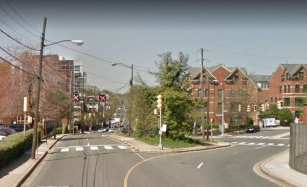
The Arlington County Board approved a contract to Sagres Construction Corporation to undertake the streetscape improvements and utility undergrounding in February 2021. Work started that spring and is expected to last 18-24 months.
“The project is still under construction and is expected to be completed this spring,” Pors said. “There’s still work to be done on signals, curb and gutter, milling and paving and landscaping.”
As part of the project, the work provided public open green space with seating and trees for a future park at the intersection, Pors said. The park will be at the northwest corner of the intersection, south of a reconfigured N. Johnson Street.
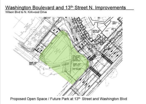
The project will also deliver wider sidewalks and improved pedestrian crossings, underground utilities, new traffic signals, street lights and street trees. It costs an estimated $6.4 million, from local commercial and industrial taxes earmarked for transportation and developer contributions.
The 2014 Clarendon Sector Plan called for these changes, which were then incorporated into the Red Top Cab properties redevelopment. The County Board approved this redevelopment in 2015, and the first phase was completed in the spring of 2021. Construction on the second phase began in January 2022.
The second phase, at the corner of Washington Blvd and 13th Street N., is comprised of a multifamily building with 269 homes.

