Modern Mobility is a biweekly opinion column. The views expressed are solely the author’s.
With my final Modern Mobility column I’d like to look back at the last few years and look ahead to the next few.
I’ll talk about what it’s been like writing Modern Mobility and how it will continue in 2022. I’ll highlight some developments in local transportation over the last few years that I think are very good or very bad, and I’ll look at the top 5 things I’m looking forward to in the future.
Looking Back — Modern Mobility
First off — it’s been a pleasure writing this column and I’d like to thank everyone who took the time to read it. Your time and attention are scarce and valuable, and I greatly appreciate you spending some of it reading my column. To those who have engaged in good faith with me in the comments, thank you — even if we have continued to disagree, I have enjoyed the dialogue. To those who have gone to the comments to complain about what you thought I said, without actually reading the column and learning otherwise, I invite you to find a more useful hobby.
Looking Ahead — Modern Mobility
While I’m losing my place here at ARLnow, I will be continuing to write on transportation while sprinkling in some general Arlington government content. Future Modern Mobility posts will be hosted as a blog here on my personal website. You can sign-up to be notified by email when new articles are posted or add the blog to your favorite feed reader (Feedly is great). I hope to continue writing about two articles per month.
Looking Back — Transportation
- Thumbs up to Vision Zero: with Arlington’s Vision Zero action plan, the County is finally working to make fundamental changes to how they operate, putting safety at the center. It’s not going to be quick and I expect there will be stumbling blocks and growing pains, but Arlington managed to adopt a plan focused on improving processes (including across departments) rather than creating a performative checklist so the opportunity is there if we can do the work.
- Thumbs down to the Fire Clearance Quagmire: Neighborhood Complete Streets sidewalk projects are stalled, protected bike lanes are being axed and entire blocks of street parking are getting ripped out, all behind closed doors with no record of when exceptions to the clear width rule are being granted, when they’re denied, and how these decisions are being made. The Virginia Fire Code grants us the flexibility to modify this clear width to meet our street safety goals, and we need to do so much more often than we are. We need transparent leadership on this from the County Manager.
- Thumbs up to kicking-off feasibility studies for upgrading the Arlington Blvd Trail around Glebe Road and extending the Four Mile Run Trail underpass beneath Shirlington Road. While only studies, and not design or construction funding, these are important first steps to solve long-standing safety issues on our trail network.
- Thumbs up to School Slow Zones and moving forward on Automated Enforcement. While designing streets that “self-enforce” safety through their design and construction is the best way to improve street safety, lower speed limits and automated enforcement have an important supporting role while we work toward that goal.
- Thumbs down to Scooters blocking sidewalks. E-Scooters have great potential to provide a much more sustainable transportation option for short trips than cars, and many folks seem willing to ride them who aren’t interested in riding a bike. Unfortunately, the public’s main exposure to these vehicles is via micromobility providers like Bird and Spin whose “dockless” model continues to fail at demonstrating it can be compatible with our street infrastructure and respectful of other users. Despite having years to train their employees to properly stage their fleets each morning and over two years of the County having the ability fine and revoke the license for these providers, scooters inhibiting pedestrian movement continues to be a frequent issue and many of our neighbors in wheelchairs do not have the ability to simply move the scooter out of their way. If Arlington can’t bring the existing providers into compliance, the only reasonable futures for e-scooters in Arlington increasingly looks to be private ownership or a “docked” rental model like Capital Bikeshare.
Looking Ahead — Transportation
Transportation developments I’m looking forward to over the next few years:
Modern Mobility is a biweekly opinion column. The views expressed are solely the author’s.
Arlington prides itself on its public engagement, but when there is a fundamental disagreement on the basic design of our streets, public engagement becomes a frustrating, repeated rehashing of the same arguments rather than a productive and collaborative conversation about what might make a particular street unique.
Arlington needs a Street Design, Operations and Maintenance Guide — a set of localized standards, tools, interventions and policies that reflect not just professional engineering standards, but also community-driven values.
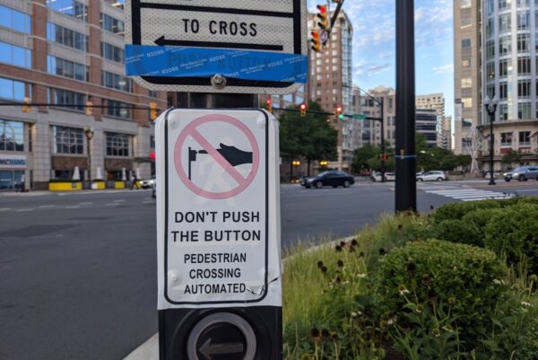
As someone who attends a lot of transportation project public meetings, I’ve heard the same feedback directed at the County in meeting after meeting: people wanting real, physical protection for bike lanes, not just paint; folks concerned that we are building wide lanes that encourage speeding; a desire to not have to push a button in order to safely cross the street; frustration with sidewalk curb cuts that seem to direct pedestrian out into the middle of an intersection rather than into a crosswalk; a desire for shelter and seating for bus stops, not just a signpost on a sidewalk.
None of these pieces of feedback is really location-specific. These requests were not because of a particular feature of the street or neighborhood where the project was being built; instead, they represent a fundamental disagreement between how Arlington currently designs and operates its streets and how residents wish them to be.
This disconnect creates a frustrating experience for both residents and for staff. Residents are frustrated, feeling like they need to go to every single transportation project engagement session and give the same feedback over and over, often with no visible results. Staff are frustrated because their engagement session, meant to help inform them about unique conditions and needs in a particular location is instead overrun with feedback about bigger, over-arching design issues that are unlikely to be changed as the result of feedback on a single project.
It’s past time for Arlington to have a community conversation about how we design, operate and maintain our streets and then put it all down in a frequently-updated, publicly-accessible guidance document. Many of Arlington’s peer localities (and nearly all larger cities) have a street design guide (Examples: Montgomery County, MD; Austin, TX; Seattle, WA; New York, NY)
An Arlington Street Guide could cover design issues (lane widths, protected bike lane materials, corner radii, etc.) as well as operational issues (signal timing policies, right-turn-on-red restriction policies, etc.) and maintenance issues (snow removal, street sweeping, pothole filling, keeping traffic calming features in good shape, etc.) and be a useful resource for county transportation staff, engineers for private developers, as well as Arlington citizens and advocates.
Providing an appropriate venue to have these broader design, operation and maintenance conversations would free up project-specific public engagement time for its intended purpose: discussing site-specific conditions that local residents may be more familiar with than County staff. On top of that, it would give an opportunity for community values and priorities to be inserted into existing county operational decisions like signal timing, pedestrian recall, etc. which are currently made entirely based on staff judgement.
With Arlington preparing to work through the “Multimodal Safety Toolkit” it promised as part of the Vision Zero Action Plan, now is the time to get started on Arlington’s Street Guide. Arlington has already started releasing for public review some of their existing guidance and the toolkit will further set out design guidance for the sort of interventions Arlington is willing to install on our streets to improve safety. With that great starting point, the County should prioritize codifying guidance on operational and maintenance procedures to create a one-stop-shop for understanding how we design, operate and maintain these critical parts of the public realm.
Chris Slatt is the current Chair of the Arlington County Transportation Commission, founder of Sustainable Mobility for Arlington County and a former civic association president. He is a software developer, co-owner of Perfect Pointe Dance Studio, and a father of two.
 Modern Mobility is a biweekly opinion column. The views expressed are solely the author’s.
I have heard some variation on that sentence more times than I can count at public engagement sessions, County Board hearings and civic association meetings: “Cars just come speeding around that corner.” They shouldn’t be able to.
A street designed for pedestrian safety uses a solid, dependable and simple technique to force cars to slow down, the “corner radius.” Arlington is building streets using corner radii that are much larger than our policies say they should and they don’t seem to be taking into account a key concept: “effective” versus “actual” curb radii. The end result: drivers can whip around a corner at a high rate of speed making them much more likely to kill or severely injure a pedestrian in the crosswalk.
If you look at any street corner in Arlington, that corner is rounded off, it doesn’t actually come to a 90-degree angle. If, in your mind’s eye, you inscribe a circle onto that corner whose outline follows the contour of the curb line, the radius of that circle is the “corner radius.”
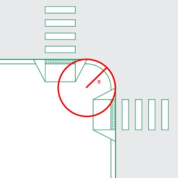
The smaller that radius, the sharper the turn a car needs to make and the slower they need to go to accomplish it.
On many streets, turning cars don’t follow the curb line because the area they are supposed to be driving on is offset from the edge of the street by parking lanes, bike lanes, etc. This means that their “effective” corner radius is much higher than the “actual” corner radius.
In this example, because the car is starting to the left of a parking lane and turning onto a street that has both a bike lane and a parking lane next to the curb, they can make a much more gently sweeping turn than the actual radius of the curb would indicate, and as a result they can make that turn at a much higher rate of speed.
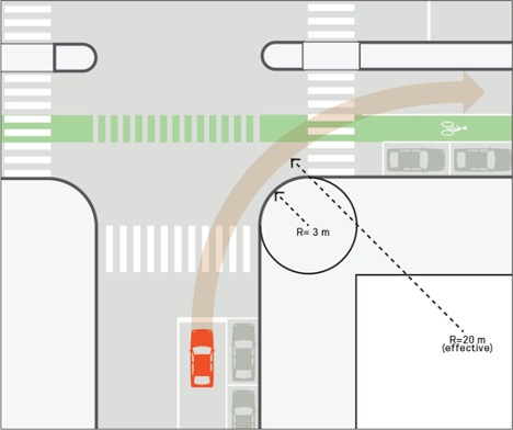
In addition to determining the speeds that cars travel through the crosswalk while turning, corner radii impact the distance that pedestrian have to walk in order to cross the street in the first place. The longer a pedestrian has to spend in the crosswalk, the longer their exposure to danger.
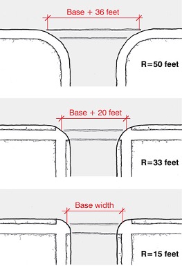
So how small should our corner radii be for safe pedestrian travel? The National Association of City Transportation Officials (NACTO) says “Minimizing the size of a corner radius is critical to creating compact intersections with safe turning speeds… In urban settings, smaller corner radii are preferred and actual corner radii exceeding 15 feet should be the exception.” The Federal Highway Administrator’s Pedestrian Safety Guide concurs: “The smallest practical actual curb radii should be chosen based on how the effective curb radius accommodates the design vehicle. An actual curb radius of 5 to 10 feet should be used wherever possible.”
Modern Mobility is a biweekly opinion column. The views expressed are solely the author’s.
Unlike most counties in Virginia, Arlington owns and maintains the vast majority of the County’s roads… but not all of them. Highways like I-395, I-66 rightly belong under the control of the Virginia Department of Transportation, but for other streets in Arlington, the value proposition is much less clear.
Do you know who owns any given road in Arlington? Ownership isn’t obvious and two roads that look similar can actually have different owners: Hayes Street in Pentagon City is Arlington-owned, Glebe Road in Ballston is owned by Virginia; Potomac Avenue is owned by Arlington, Langston Blvd by Virginia.
These ownership differences can make major differences when it comes time to make improvements to these streets to meet our Vision Zero goals and address safety issues. Design and construction on state-owned roads require a long and lengthy approval process from the state and urban-appropriate street design configurations often require special waivers from VDOT whose standards are highway-focused.
This lack of flexibility has been a problem in the past. In 2010 Arlington sought and received ownership of Columbia Pike to facilitate its reconstruction from an auto-centric arterial to a pedestrian-friendly Main Street. The massive rebuild of Columbia Pike has been long and arduous as it is, adding state approvals to the process might have stretched the timeline beyond feasibility.
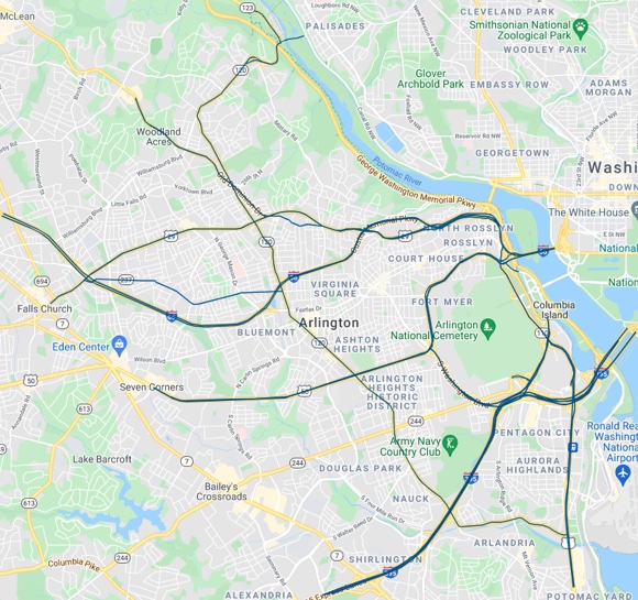
In 2018 Arlington sought and received ownership of VA-237 which is the designation for parts of 10th Street N. and Fairfax Drive to give Arlington flexibility on making pedestrian improvements there as well.
With Langston Blvd going through a reimagining process that is likely to result in a dramatic transformation in the future, now is the time for Arlington to seek control of Langston Blvd from the state to facilitate that transformation. With large parts of Glebe Road appearing on Arlington’s High Injury Network, control of the high-pedestrian areas of Glebe Road, to facilitate safety improvements, would also be wise.
The additional maintenance costs of these acquired streets would be somewhat, but not entirely, offset by the state. Arlington is reimbursed for each lane mile of street they maintain, but historically that amount does not fully cover what Arlington pays out per year in maintenance for each lane mile of street.
The additional benefits — local control of our streets and the ability to deliver better safety interventions more quickly — are well worth that price.
Chris Slatt is the current Chair of the Arlington County Transportation Commission, founder of Sustainable Mobility for Arlington County and a former civic association president. He is a software developer, co-owner of Perfect Pointe Dance Studio, and a father of two.
 Modern Mobility is a biweekly opinion column. The views expressed are solely the author’s.
Arlington recently announced the end of one of the only good things to come out of the pandemic: the widespread implementation of automatic pedestrian phases on many of our traffic signals.
In many areas, pedestrians will have to go back to pushing a button in order to trigger an opportunity to safely cross the street. The response from many has been “pushing a button is not a big deal,” and indeed, pushing a button is not hard or onerous; what is a big deal is the guaranteed additional pedestrian delay that comes along with it, the negative effect on accessibility and the message that it sends.
Unnecessary Pedestrian Delay. How much? It’s complicated.
When the signal is set to go to walk automatically (called “pedestrian recall”), a pedestrian has a decent chance of arriving at the intersection and encountering a fortuitous set of circumstances: the walk signal has already come on and that there is enough time left in the countdown for them to safely cross the street. In this instance, the pedestrian encounters zero delays, they can immediately cross the street.
A pedestrian approaching this same intersection in “actuated mode” where a button press is required, at the exact same point in the signal timing will encounter one of a couple of different circumstances. If a car going the same direction has been sitting there waiting and has tripped the light then they might have a walk signal and still encounter zero delay — or the car may have a green but the signal may not present a walk signal so that it can provide a shorter green for this cross street than the amount of time it takes a person to safely cross, in which case they will encounter a “don’t walk.” Pressing the button now will require waiting the full length of the remaining signal plus the entirety of the green for the crossing direction. If there isn’t a car going the same direction as them to trip the light, then they definitely don’t have a walk signal. Pressing the button will require an unknown wait time that depends on whether that signal is “coordinated” with other nearby signals as well as what the “minimum green time” is for the crossing traffic direction.
With all of the various ways that a traffic signal can be programmed it’s impossible to say at a high level how much these changes are going to slow down pedestrians, but Arlington’s DOT absolutely could. Average pedestrian delay given a set of signal timings is an easy calculation. At a minimum, Arlington should do this calculation for all signals that are proposed to be put back on actuation so Arlingtonians can fully understand what is being proposed.
Safety & Accessibility
While delaying people walking is obnoxious, especially given that it affects us all — we all, at some point in time have to try and cross the street. There is also a safety impact — both studies and a basic understanding of human nature tell us that the longer people have to wait to safely cross the street, the more likely they are to unsafely cross the street. This decision is in clear opposition to our Vision Zero goals.
The press release announcing these changes indicates that they are doing so to “improve walkway safety;” Arlington County spokesperson Jessica Baxter explained to Greater Great Washington that “the theory amongst professionals is when there is manual input by a pedestrian at a walkway, pedestrians are more likely to pay attention to their surroundings.” In all of my time looking at transportation research and learning about transportation safety, I have never before heard this theory.
It is, however, a theory — not peer-reviewed research. It is also predicated on a notion that “distracted walking” is a significant contributor to crashes. This is a trope that has been debunked by actual research — distracted walking has a minimal effect on pedestrian behavior. A meta-analysis of all studies on distracted walking does not show any increased risk for pedestrians. What does increase risk of pedestrian crashes? Speeding, intoxication and driver inattention.
Pedestrian recall is also much more accessible for wheelchair users who may have difficulty accessing the push button and those with low or limited vision who have difficulty locating the push button.
 Modern Mobility is a biweekly opinion column. The views expressed are solely the author’s.
Most of Arlington’s current Protected Bike Lanes have a weak point: bus stops.
While riders have a largely low-stress, comfortable ride separated from moving cars by parked cars, that protection falls away at the bus stop where they need to mix with large vehicles that have somewhat limited rear and side visibility.
Floating bus islands to the rescue!
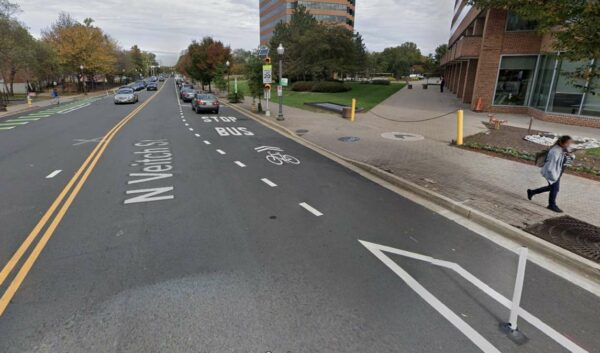
What is a Floating Bus Island?
With a floating bus island, the bus stop moves out to a sidewalk-level island that lines up with the protection for the bike lane. So with a parking-protected bike lane, the bus island aligns with where the cars park. From the sidewalk, bus users cross the bike lane and then wait on the island for the bus to arrive. The bus pulls up, stops in the travel lane, picks up and drops off passengers, and then continues on its way.
Having trouble picturing what this looks like? No worries, Arlington has one on Wilson Blvd near the new HB Woodlawn building so you can check it out for yourself (or just check out these photos).
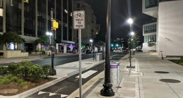
This setup is both great for people on bikes — no more mixing with big scary vehicles — but also great for transit. Since the bus doesn’t have to pull to the curb, it also doesn’t have to pull back into the travel lane. This saves the bus (and the many folks on the bus) all of the time it would normally spend waiting for a break in traffic to pull back into the travel lane. Added together over the course of many stops, this can have a noticeable impact on how long the bus takes to get you to your destination.
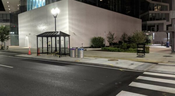
Why don’t we have more of them?
Arlington now has several protected bike lanes, why do we only have one floating bus island? Generally, because Arlington has achieved most of their protected bike lanes as opportunistically as part of repaving, rather than as part of a capital project. During a repaving project, options are much more limited which is why they are generally made with paint and plastic bollards.
The floating bus island on Wilson Blvd. was built as part of a redevelopment project, where curbs were already being changed and concrete was already being poured. More floating bus islands are coming as part of future capital projects; several will be built as part of the Army Navy Drive Complete Streets project, for example.
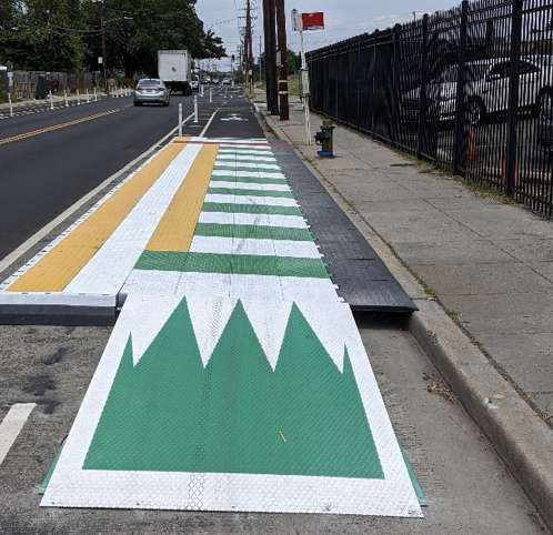
It doesn’t have to be this way, however — we don’t have to wait for a capital project. Cities like D.C. and Portland have started creating floating bus islands with a modular product that can be dropped into place, enabling them to be installed as part of simple repaving and restriping projects, rather than requiring a costly capital project that pours new curbs.

Arlington should add this or a similar product to its repaving project toolbox. It would drastically improve the quality of protected bike lane infrastructure that can be installed as part of repaving or other quick-build projects as well as speeding up transit operations, reinforcing our investment in bus service in Arlington.
Chris Slatt is the current Chair of the Arlington County Transportation Commission, founder of Sustainable Mobility for Arlington County and a former civic association president. He is a software developer, co-owner of Perfect Pointe Dance Studio, and a father of two.
 Modern Mobility is a biweekly opinion column. The views expressed are solely the author’s.
Protected bike lanes on Fairfax Drive are a project whose time has come.
It’s a critical link that would connect commercial areas, parks, and trails to thousands of Arlington residents. It deserves a place in Arlington’s next 10-year Capital Improvement Plan.
Why Protected Bike Lanes?
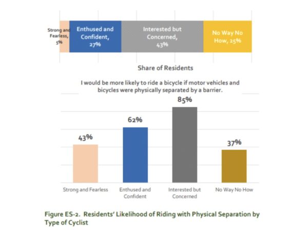
Over the years, we have learned that standard painted bike lanes, like the ones currently on Fairfax Drive, mostly benefit people who are already biking — the confident and fearless cyclists who are already out there on the streets. To making biking work for a wider audience, those who are interested but concerned, we need low-stress facilities like protected bike lanes and trails.
Arlingtonians support more protected bike lanes — when surveyed as part of the last update of the Bicycle Master Plan, 48% of respondents indicated that safety concerns were their primary reason for not biking more and 64% supported more protected bike lanes to solve that problem. Nationwide, we find that once people have experienced protected bike lanes for themselves, support climbs even higher. 75% of people who live near a protected bike lane project say they support more of them in other locations.
Additionally, protected bike lanes are good for business. Protected bike lanes bring more riders – the average protected bike lane sees rider counts increase 75% in the first year alone — and bike riders spend the same at retail each month as people who arrived by car. They buy less each visit but visit more frequently. A Protected Bike Lane project in Salt Lake City that removed 30% of the street parking to install a protected bike lane saw retail sales along the corridor rise by a higher percentage than sales in the rest of the city. A Protected Bike Lane project in NYC on 9th Avenue resulted in drastically higher retail performance.
Finally, protected bike lanes help prevent scofflaw drivers from parking in the bike lanes — a common issue on Fairfax Drive.
https://twitter.com/howisthatlegal/status/1186307198030417921
moments earlier, at the Fairfax Drive bike lane, the Fairfax Drive loading zone, the combination Fairfax Drive bike lane and loading zone pic.twitter.com/pZdifpMrWP
— chelsea (@CCsaywhat) March 5, 2021
Why Fairfax Drive?
Fairfax Drive forms a critical east-west path through the County, especially for bikes and scooters. On the west end, it connects to both the Custis Trail and the Bluemont Junction Trail. In the east, it connects to Clarendon Circle where the Wilson Blvd and Clarendon Blvd bike lanes begin. In between in connects commercial areas, Metro Stations, parks, Central Library, the George Mason University campus and more.
There are few, if any, nearby parallel streets appropriate for cycling. Neither Washington Blvd nor Wilson Blvd in the vicinity have bike facilities. One can piece together a decent stretch of 9th Street N., but safely crossing Quincy Street without a four-way stop or traffic signal is difficult, it does not connect well on the West end to the trail network and it falls apart on the East end well short of Clarendon Circle.
Finally, adding protected bike lanes to Fairfax Drive is a chance to make a host of design changes that would make the street safer for everyone. As a former VDOT road, Fairfax Drive has been built almost exclusively to speed motor vehicles — safe crossings are far apart, corners were built to allow high speed turns across crosswalks, lanes are wide and encourage speeding. This section of Fairfax Drive is not just on Arlington’s High Injury Network, it’s #2 in fatal and serious injury crashes per mile in Arlington County.
 Modern Mobility is a biweekly opinion column. The views expressed are solely the author’s.
The 20′ Clear Width rule of the VA Fire Code has removed on-street parking that had existed safely for decades, prevented the installation of protected bike lanes and made new sidewalk installations politically infeasible — and you’ve probably never heard of it. This rule can save lives by speeding fire response or cost lives by preventing safer street designs. Is Arlington finding the right balance?
What is the 20′ Clear Width Rule?
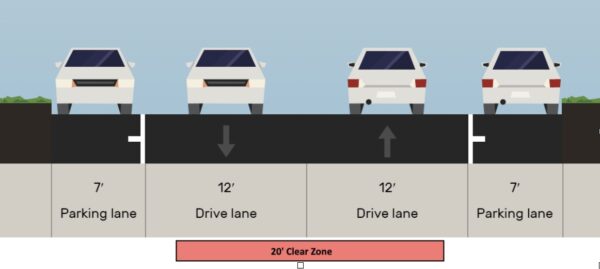
The 20′ Clear Width rule is codified in section 503.2.1 of the VA Statewide Fire Prevention Code: “Fire apparatus access roads shall have an unobstructed width of not less than 20 feet.”
A fire apparatus access road is, essentially, every road, street and driveway that a fire truck might need to drive on to get from the fire station to a structure that is on fire.
What makes an area obstructed? The Arlington Fire Department says that this area “does not have to be completely flat,” but past projects seem to indicate that curbs or medians within this area are not allowed.
Here is an example Arlington residential street that more than meets the 20′ clear width rule because of its two adjacent, wide travel lanes:
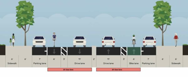
And here is an example arterial street with buffered bike lanes that meets the 20′ clear width rule because of the combination of the travel lane, buffer and bike lane, despite the car lanes being separated by a raised median:
What is it supposed to accomplish?
The Arlington Fire Department helpfully explains that the 20′ clear width rule is designed to make sure there is “continuous and unobstructed access to buildings and facilities” and to provide a “safe operational area around the fire apparatus to access compartments and equipment.”
The clear width isn’t so much to speed the truck’s arrival at the scene, fire trucks generally fit fine in normal lanes and factors like good grid connectivity are much more influential on response time than street widths. The clear width is to ensure that when the truck gets to the fire, there is space to park, extend outriggers (if necessary) and safely and easily access the equipment stored in and around the truck needed to fight the fire.
To the extent to which having 20′ of clear space at the scene of a fire speeds up response time by helping them quickly get set up and working, this portion of the fire code should help save lives in an emergency where every second counts.
 Modern Mobility is a biweekly opinion column. The views expressed are solely the author’s.
May is Bike Month, and from what I’ve seen out and about so far, lots of you are already celebrating.
The pandemic has caused a lot of folks to drag an old bike out of the garage, pick one up from a local bike shop or just ride more frequently, which is fantastic to see. There are some great, free activities this month to help keep you on your riding journey.
Celebrate Bike Month with BikeArlington
BikeArlington is doing a bunch of fun events and challenges for the whole month of May, you can still register here. The first week, we got a prompt to encourage us to ride (Replace One Car Trip: try to make one trip this week that you would normally make in a car, on a bike) as well as delicious weekend deals (25% off at Nicecream? Yes, thank you!).
Bike to Work Day
Bike to Work Day is back for 2021 on Friday, May 21, after being cancelled in 2020, with some modifications to support COVID safety. Get your free T-shirt, some exercise and some fresh air. You can register here. Aren’t going in to the office? No problem – it’s a good excuse to just bike to your local pit stop, or anywhere really.
Bike to Work WEEK
If Bike to Work Day isn’t enough for you, the National Landing BID is continuing their tradition of hosting Bike to Work Week from Monday (May 17) to Friday (May 21) from 7 a.m.-9 a.m. at the Crystal City Water Park. Again, modifications have been made to ensure COVID safety, so don’t expect to linger. Participants who check-in all 5 days will earn coveted, exclusive National Landing Cycling Swag. Register here.
This beautiful May weather is a great chance to explore and learn how easy it can be to bike for those short trips that make up the majority of our typical travel. The majority of trips the average American takes are less than 6 miles. Bike to dinner, bike to ice cream, bike to the park, bike to the dentist, or bike to the pharmacy to pick up your prescription. You won’t sit in traffic, you won’t have to pay for parking, and it’s amazing what you’ll notice about your neighborhood when aren’t inside a steel & glass bubble.
I hope to see you out there! Be sure to wave!
Chris Slatt is the current Chair of the Arlington County Transportation Commission, founder of Sustainable Mobility for Arlington County and a former civic association president. He is a software developer, co-owner of Perfect Pointe Dance Studio, and a father of two.
 Modern Mobility is a biweekly opinion column. The views expressed are solely the author’s.
Arlington has grown and thrived as a result of transit-oriented development, but is it time for a new TOD in Arlington: trail-oriented development?
In many places, including the DC area, developers are seeing trails as desirable places to be and creating buildings that embrace the trail as an amenity to be cherished, rather than turning their back on the trail as so many existing buildings do.
Many of these buildings are primarily residential. They provide easy, direct connections to the trail for their residents, as well as amenities like wider hallways for wheeling bikes directly back to your unit, bike repair areas, etc. Having more people living where they can safely, easily and enjoyable bike and walk is great for our climate goals.
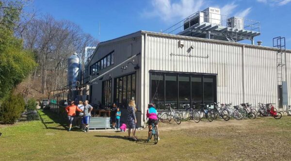
A more interesting pattern, in my opinion, are when retail spaces embrace the trail. One example of this is Caboose Brewing out in Vienna. While it has a standard drive up and park your car entrance, it also has a direct entrance from the W&OD Trail with bike racks. As you can see from this photo, many folks take advantage of this option.
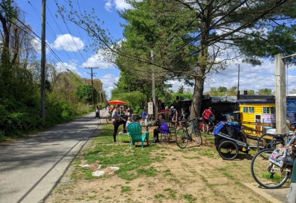
I saw an even more active and varied example of this recently on the Baltimore & Annapolis Trail. Nearly every business in this trail-adjacent strip mall had a usable back-entrance & there was a shared seating area along the trail adjacent to them. The coffee shop even had a little walk-up window where you could order from the trail side without setting foot inside the shop.
The seating area is pictured here along the trail, the retail shops are in the far right of the photo.
This area was clearly a gathering place for the community. It was busy every time I biked by over the weekend.
Where could we create these kinds of places in Arlington?
One possible option is the Arlington Boulevard Trail. The Days Inn site, at the corner of Pershing Drive is expected to redevelop in the near future and could be a fantastic spot to create this sort of trail/retail synergy. Currently the design guidance for the Days Inn site doesn’t call for such a thing, but that design guidance is open for comment now if you care to provide that sort of feedback to staff.
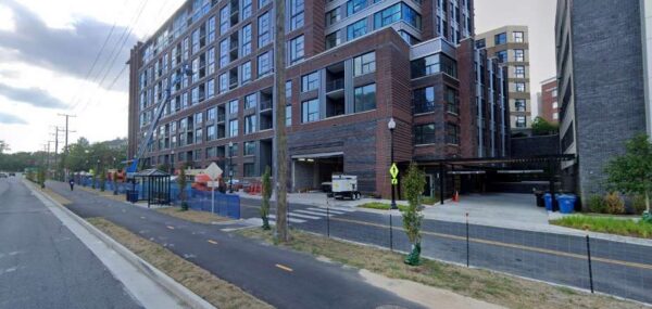
There are additional opportunities on the Arlington Boulevard Trail further east. While the development picture below kept the trail sandwiched between Fairfax Drive and Arlington Boulevard, the trail will likely need to cross Fairfax Drive somewhere before it reaches Rosslyn, putting the trail directly adjacent to the higher density buildings on the north side of Arlington Boulevard. This could be another opportunity for trail-oriented retail spaces.
Really, this is an opportunity to set a different character for the Arlington Boulevard Trail. Given its placement, it will never be the quiet leafy oasis that some of our other trails try to be. Instead, it could be the bustling community gathering trail with nodes of lively commercial activity.
While potential spots along the Custis, Bluemont Junction or W&OD are rare, they do exist. Any redevelopment in the Lyon Village Shopping Center could embrace the Custis in a big way and there are some commercial buildings in the vicinity of Pupatella in Bluemont that back up to the Bluemont Junction Trail offering some opportunities as-is.
Trails are good for business; they are a desired amenity that people want to live near, and people walking and biking tend to buy more locally. Having more activity adjacent to the trail creates more “eyes on the trail,” improving safety. Trail-oriented Development is an underutilized tool in the County’s planning toolbelt and we should use it more.
Chris Slatt is the current Chair of the Arlington County Transportation Commission, founder of Sustainable Mobility for Arlington County and a former civic association president. He is a software developer, co-owner of Perfect Pointe Dance Studio, and a father of two.
 Modern Mobility is a biweekly opinion column. The views expressed are solely the author’s.
The County is in the midst of putting together their Capital Improvement Plan (CIP) for the next three years.
This document will determine what projects get built in the near future, from transportation to parks to stormwater infrastructure.
This is an opportunity to reset our priorities and “build back better” to a transportation system that is safe and sustainable.
Arlington’s Capital Improvement Plan should:
- Fund Vision Zero
Arlington is expected to adopt their Vision Zero Action Plan later this Spring. The Vision Zero plan envisions a comprehensive, safe-systems approach to identifying the common factors that contribute to Arlington’s severe and fatal crashes and to address those factors systematically.
Safety isn’t sexy, but failing to address it has an immeasurable cost. We need a dedicated pot of money that is always working to address those factors that are contributing to deaths and serious injuries on our streets.
- Build out the Bike Network for All-Ages & Abilities
In 2019 Arlington adopted a new vision for biking in Arlington, where biking is “an integral part of Arlington’s equitable, multimodal transportation system and provides safe, reliable, convenient and comfortable travel for persons of all ages and abilities.”
Arlington’s approach to bike infrastructure has largely been an after-thought. Projects are identified for other reasons, and “while we’re at it” we look to see if anything can be accomplished to improve biking as part of the project. This approach will never result in a comprehensive network for all-ages and abilities. We need dedicated funding to tackle the projects that matter most for biking.
- Speed up our Transit
Arlington has invested significantly in our bus network over the last 15 years, but those buses often struggle to attract riders when they sit in the same traffic as drivers while also waiting unnecessarily for long, slow boarding processes at each stop. Arlington needs to maximize the return on its transit investment by prioritizing projects that speed up our buses: dedicated bus lanes, transit signal priority, queue jumps and support for all-door boarding.
- Safe Routes to Every School
Kids who walk and bike to school arrive happier and more focused. Walking & biking to school fights childhood obesity and raises a new generation that views walking and biking as normal everyday transportation modes. Making sure that kids have a safe route to walk or bike also helps control APS transportation costs and builds community ties. Every place that APS limits a school’s “walk zone” because of a dangerous street or intersection is a failure that needs to be addressed.
- Expand & Connect the Trail Network
When Arlington conducted a statistically-valid survey of recreational needs in 2016, paved multi-use trails were ranked the “most needed outdoor facility” with 87% of households indicating a need. Since that time, little progress has been made. The Capital Trails Coalition has laid out a vision for an expanded, interconnected trail system in the DC region. Arlington needs to do its part to see this vision realized by making progress on the Arlington Boulevard Trail and the Cemetery Wall Trail.
Arlington County is seeking input on your priorities for the upcoming Capital Plan. You can weigh-in here through this Friday, April 16th.
Chris Slatt is the current Chair of the Arlington County Transportation Commission, founder of Sustainable Mobility for Arlington County and a former civic association president. He is a software developer, co-owner of Perfect Pointe Dance Studio, and a father of two.


