 Modern Mobility is a biweekly opinion column. The views expressed are solely the author’s.
Columbia Pike is one of Arlington’s least bike-friendly corridors — there aren’t any bike lanes, traffic is heavy, and the bike boulevards on parallel streets are disjointed and disconnected.
Almost 3 years ago now, Bike4ThePike rode to highlight this fact, along with the gaps in the County’s plans for the Pike.
Today, we have a big opportunity to close ones of those gaps, but the County’s going to need some help to do it.
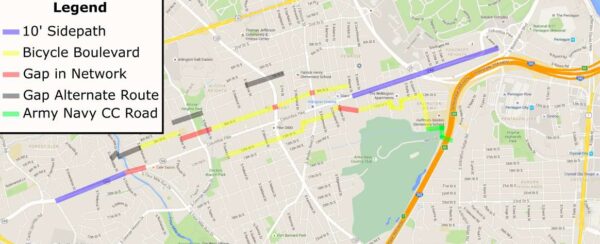
Three years ago, this is what the map looked like for the County’s planned bike facilities along the Pike.
We’ve made some progress — the sidepath on the bridge over Four Mile Run will be widened this year. The Complete Streets project on Walter Reed Drive is moving forward and is likely to add a traffic light at 9th Street S to create a safe crossing there for bike boulevard users — but the North side still has a fair number of gaps.
With the completion of the new section of 12th Street S between Rolfe and Ross Street, built by the Trove development, the south-side Bike Boulevard only has one major gap remaining — Barton to Wayne Street.
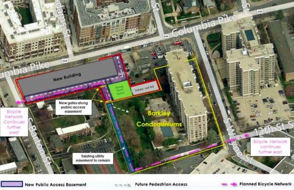
The redevelopment project at 2400 Columbia Pike (which includes the current Rappahannock Coffee building, among others) offers an opportunity to finally bridge this gap, but it will require help from the developer, the County and the Barkley Condominiums. This development was originally approved in 2016, but is back undergoing review with some revisions.
The Form-based Code requires this development to have an east-west alley. Since this alley would serve only traffic from this one building, it could, if designed well, function as a quiet, low-stress place to bike much like the rest of the Columbia Pike Boulevards. However, the alley itself only goes as far east as this development does — it wouldn’t connect to Wayne Street.
It was noted during the last review of this project that a connection could be possible to Wayne via the construction of a small stretch of trail on property owned by the Barkley Condominiums; part of this land already has a utility easement granted to the County for some buried utilities. There are certainly many routes that such a trail could take, but here is one potential alignment that was shown the last time this development was reviewed (pink dashed line):
Why might Barkley Condominiums want to grant such an easement? Here are a few thoughts:
- It was noted during the last review of this project that the condo residents have been using the existing alley to walk from the back of their condo building to the Pike, despite having no legal easement to do so. It was also noted that the Condo building has relied on the existing private alley to provide access to maintenance crews to complete work on the rear of their property such as landscaping; again, without the legal right to do so. The trail could provide a safer, more pleasant, and legal access route for both condo residents and maintenance crews to access this side of the building.
- Generally, trails are a sought-after amenity that raise property values. In this instance, the County would be constructing and maintaining the trail. The Barkley would simply need to provide legal access to the land. The land that already has the utility easement over it isn’t useful for much of anything else anyway.
- Being a good neighbor. This is one problem on the Pike, that is extremely difficult to solve without the Barkley’s assistance. If we don’t fix this now, people who want to bike here will be relegated to the narrow sidewalks of the Pike or mixing it up with heavy Pike traffic for the foreseeable future, barring a joint redevelopment of two gas stations and Bob & Edith’s diner (please no!).
This sort of trail easement isn’t unprecedented — the Four Mile Run Trail runs behind the Brittany and the Carlton Condominiums along Four Mile Run Drive, on land that appears to be owned by the Condo Associations, presumably in a similar easement.
I think it’s important that everyone involved know that this gap in the bike network is important to citizens along the Pike. If you support a bike-able Columbia Pike and would like to see the Rappahannock Developer, the County and the Barkley Condominiums come together to solve it, please consider signing this petition that Sustainable Mobility for Arlington County launched yesterday. You can also ask the developer about the biking experience in their proposed alley at this virtual meeting tonight at 7 p.m. about the development proposal.
Chris Slatt is the current Chair of the Arlington County Transportation Commission, founder of Sustainable Mobility for Arlington County and a former civic association president. He is a software developer, co-owner of Perfect Pointe Dance Studio, and a father of two.
 Modern Mobility is a biweekly opinion column. The views expressed are solely the author’s.
The public meetings around the Shirlington Road Bridge project have reignited a long-standing community conversation about crossing safety near Four Mile Run Drive and Shirlington Road that has gone on for at least 10 years.
The area, at the confluence of the W&OD Trail, several legs of the Four Mile Run Trail, also suffers from a bridge over Four Mile Run that only has a sidewalk on one side, with that sidewalk being extremely narrow, traffic coming off of a major interstate highway, and a very auto-centric built environment with many curb cuts crossing the sidewalks and large trucks from the concrete plant.
These factors all coming together in such a small area leads to a situation where no one is comfortable. Trail users feel like there are no safe way for them to get through the area. Drivers feel like they already have too many things to keep an eye out for and trail users are adding to that complexity.
The Shirlington Road bridge project will help a bit — fixing the narrow sidewalk on the bridge by adding a wide, comfortable parallel bike & pedestrian bridge as well as making the mid-block crossing near 27th Street more prominent and eye-catching, but community feedback at both the recent public meeting as well as the Green Valley Bridges Ad Hoc Working Group make it clear that there is more work to be done.
The remaining issue is the crossing of Shirlington Road; it’s easiest to think about this from the perspective of someone who has just gone under 395 on the trail and is trying to continue to the West, either on the W&OD Trail or down on the Four Mile Run Trail (perhaps on their way to shop in Shirlington).
A trail user’s most obvious choice is the mid-block crossing immediately before them, but reports from existing trail users are that cars often don’t stop for the Rectangular Rapid Flash Beacon (RRFB). Adding a HAWK signal or traffic signal at the mid-block crossing have been ruled out by the County due to the proximity to the existing traffic signals.
A trail user heading for the W&OD could head north on the sidewalk to cross at Four Mile Run Drive, but this brings along new conflicts — cars entering and exiting the Exxon as well as concrete trucks going to and from the concrete plan. Additionally, even those crossing Shirlington Road with the walk signal find there are dangerous conflicts — cars turning left from Four Mile Run Drive onto northbound Shirlington Road as well as cars making a right-on-red from Shirlington Road to Four Mile Run Drive and who aren’t paying sufficient attention to yield. Read More
 Modern Mobility is a biweekly opinion column. The views expressed are solely the author’s.
Two regional governmental bodies, that don’t receive much detailed coverage in the press, could have a big impact on the transportation options available to you, the quality of the air you breathe and our ability to meet our climate goals.
Have you heard of the National Capital Region Transportation Planning Board (TPB)? Or the Northern Virginia Transportation Authority (NVTA)?
The Transportation Policy Board (TPB)
The TPB is the DC area’s Metropolitan Planning Organization and it is supposed to do transportation planning for the entire DC-area – including all regionally-significant transportation projects in the Maryland and Virginia suburbs as well as DC itself. By federal law it is responsible for ensuring that those projects improve the area’s air quality.
TPB has some great “aspirational goals” that could really lead the region into a healthier, more sustainable transportation future:
- Bring jobs and housing closer together
- Expand bus rapid transit and transitways
- Move more people on Metrorail
- Increase telecommuting and other options for commuting
- Expand the express highway network
- Improve walk and bike access to transit
- Complete the National Capital Trail
The chair of the Metropolitan Washington Air Quality Commission’s comments on the current transportation plan note that it is critical for the region to reduce per capita vehicle miles travelled (VMT) in order to achieve air quality standards and implores TPB to invest in “Metro, ride-sharing, pedestrian and bike infrastructure, and other travel demand management strategies to continue to mitigate future growth in vehicle emissions.”
Unfortunately, when the rubber meets the road – in this case, when it comes time to put together its “constrained long-range plan” of all regionally-significant transportation projects, the TPB seems content to basically staple together MDOT’s, VDOT’s and DDOT’s transportation plans, without significant examination of whether any given project moves the region forward toward those “aspirational goals” or prepare us for future, cleaner air quality standards.
A good example here is Maryland’s reconstruction of the “Nice” bridge across the Potomac south of DC. Maryland’s DOT was looking to drop plans for a promised bicycle and pedestrian accommodation on the replacement bridge (which will double capacity for cars) the TPB passed an amendment to the regional plan allowing the project to move forward with no dedicated space for non-motorized traffic on this important river crossing which has no alternative for miles in any direction. Another is their acceptance of Maryland’s I-495 and I-270 Express Lane projects without any commitment that they will allow High Occupancy Vehicles to travel toll-free.
TPB will be updating their regional plan “Visualize 2045” over the course of the next two years. You can sign-up for email updates here.
The Northern Virginia Transportation Authority (NVTA)
The NVTA gets 70% of the regional tax revenue that is dedicated to transportation (from a wholesale tax on gasoline, along with some other sources). It then doles that money back out as grants for transportation projects.
 Modern Mobility is a biweekly opinion column. The views expressed are solely the author’s.
The Arlington County Board is set to vote this weekend on accepting a grant to implement a performance parking pilot in Arlington’s Metrorail corridors.
Performance Parking is a proven approaching to managing parking supply to make parking more convenient. It uses technology to measure parking demand, and over time matches the price of that parking to demand, ensuring that parking is generally available where people want it, when people want it.
How Does it Work?
When trying to understand how performance parking works, it’s helpful to look at an existing example while keeping in mind that there are many ways to customize a performance parking implementation plan to fit each community. One of the most well-known and well-documented examples is SFPark in San Francisco.
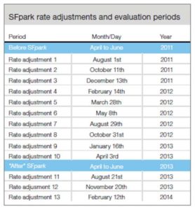 The SFPark pilot installed in-pavement parking occupancy sensors across 7 parking management areas which included about 25% of the city’s on-street spaces. Approximately every 8 weeks, the city adjusted parking rates for each block based on average parking occupancy of that block, according to the following formula: blocks that saw 80-100% occupancy the rate was increased by $0.25, blocks where the occupancy was 60-80% the rate was left alone, blocks where occupancy was 30-60% the hourly rate was decreased by $0.25, blocks where the occupancy rate was below 30% the hourly rate was decreased by $0.50.
These pricing adjustments were made approximately every 8 weeks. Unlike something like Uber’s Surge pricing, these are not sudden, real-time changes – they are slow, deliberate changes made over a period of months with clear, predictable signage. Over time they find the true intersection of the parking supply and demand curves and ensure that parking is available on each block when people need it.
What does it Accomplish?
 SFPark made parking easier to find. The amount of time that blocks achieved the target parking occupancy (60 to 80%) increased by 31% in pilot areas, compared to a 6% increase in control areas. The amount of time that blocks were too full to find parking decreased 16% in pilot areas while increasing 51% in control areas.
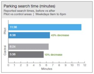
SFPark saved people time. In SFpark pilot areas, the amount of time most people reported that it took to find a space decreased by 43%, from about 11 ½ minutes to about 6 ½ minutes.
 SFPark reduced greenhouse gas emissions. Due to reduced time spent circling for a parking space, drivers went from generating about 7 metric tons of ghg emissions per day looking for parking prior to the pilot to about 4.9 metric tons of emissions per day after the pilot.
SFPark reduced double parking. Double parking increases dramatically as convenient parking gets harder to find. In SFPark pilot areas, double parking decreased by 22% compared to a 5% decrease in the control areas.
SFPark reduced congestion and improved transit speeds. Due to a reduction in drivers circling for spaces and the reduction in double parking, peak period congestion decreased and transit speed increased in the pilot areas.
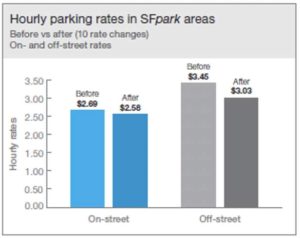
SFPark lowered average hourly parking meter rates. Over the course of the SFPark pilot, the average hourly rates at meters dropped from $2.69 to $2.58.
 Modern Mobility is a biweekly opinion column. The views expressed are solely the author’s.
(Updated at 9:25 p.m.) Enforcement of traffic laws is one of the key pillars to safety on our streets. No matter how well-engineered our streets are to encourage good behavior, if people are able to blow through red lights or exceed a safe speed with their vehicle, our streets will never be safe.
Unfortunately, our current methods of doing traffic enforcement bring their own set of problems. Police forces that are already struggling with staffing levels see traffic enforcement as a low priority making enforcement rare and sporadic, and traffic stops have proven to be the #1 pretext for harassment of black people. Automating enforcement of common traffic violations like speeding, running red lights and running stop signs can both improve safety on our streets for everyone, remove potential bias and reduce unnecessary encounters between residents and armed police officers.
Problems with the Status Quo
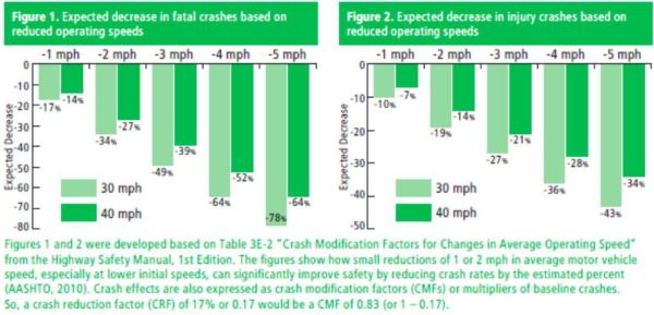
Street safety is a major concern in Arlington. A quick look at Arlington’s Vision Zero map (submissions accepted through Friday) shows concerns all around the county, including many concerns about speeding. The old adage, “Speed Kills” is truer than many people realize. Even a small 2mph decrease in average vehicular speed can result in as much as a 34% reduction in fatal crashes.
While local data seems lacking here, nationwide the injuries and fatalities that result from this lack of enforcement fall primarily on low-income and non-white households. Low income pedestrians are 2x as likely to be killed while walking as high income pedestrians. Even adjusting for population, non-white pedestrians in Virginian are 46% more likely to be killed while walking than white pedestrians.
Advantages of Automation
Automated enforcement could provide the kind of constant feedback that is necessary to change behavior. Research on behavior change has shown that feedback must be swift, certain and fair. Our existing enforcement is far from certain, and there are legitimate questions in our community about whether our traffic laws are being enforced fairly. Currently a tiny percentage of speeders, stop sign runners and red light runners get caught. This lack of certainty in enforcement causes it to generally fail to cause behavior change. Automated enforcement could ensure that a much higher percentage of these infractions are caught and issued a fine, leading to fewer people committing these unsafe infractions. Chicago’s DOT, for instance, recently reported that 92.7% of drivers ticketed for speeding in school zones in 2019 didn’t receive a second ticket.
 Modern Mobility is a biweekly opinion column. The views expressed are solely the author’s.
The title of today’s column is a common adage in the planning world that’s at least 30 years old; I regret that I do not know its original source to provide credit.
At its heart, it reflects the insight that the best way to ensure people can quickly and easily get to the places that they need to go is to ensure that they don’t have to go as far to get there – trips, on average, become shorter.
For motorists, shorter trip lengths mean you drive through fewer intersections and along fewer segments of street which means fewer cars on each street at a time which means less congestion. Shorter trips are also more convenient for active transportation like walking and biking – many folks would walk a few blocks to a restaurant who wouldn’t walk a mile. Many folks would bike a mile to a doctor’s appointment would wouldn’t bike 10 miles. The result? More trips by means other than car.
Many parts of Arlington’s land use plan embrace this. Arlington’s original “urban village” planning maxim was designed around creating neighborhoods, centered around good transit, where people had ready access to work, play and everyday needs like shopping.
For someone living in the denser corridors of Arlington, a huge number of useful destinations are reachable on foot, many more by bike and even more by frequent transit. They may choose to have a car, or some may need a car because of a job located far from transit or a job that requires traveling to many different sites on a daily basis, but many are able to happily live car-free or car-lite and those who do drive generally make shorter trips in those cars.
This growth strategy, along with continued investment in multimodal transportation facilities has allowed Arlington to grow its economy and its population while also holding traffic levels relatively stead, adding new parks (like Long Bridge Park and Mosaic Park) and reducing the relative carbon impact of our residents.
As Arlington embarks on a Missing Middle Housing study, a look at transportation and density in Pentagon City, the Plan Lee Highway Study and a re-examination of some details of the Clarendon Sector Plan, we would do well to remember that everything is easier, from a transportation standpoint, if you let people live nearer to where they want to go on a regular basis.
Chris Slatt is the current Chair of the Arlington County Transportation Commission, founder of Sustainable Mobility for Arlington County and a former civic association president. He is a software developer, co-owner of Perfect Pointe Dance Studio, and a father of two.
 Modern Mobility is a biweekly opinion column. The views expressed are solely the author’s.
(Updated on 11/11/20) On Saturday, the Arlington County Board voted 4-1 to endorse the County’s application for $25 million in grant money for VDOT’s Arlington Blvd Safety Improvements Project, covering the area from Glebe Road to Fillmore Street.
That grant money, if awarded, would not be disbursed until 2026, meaning construction is at least six years, if not seven or eight years away. VDOT’s decision to select a costly, construction-intensive capital project to solve the safety issues in this stretch means our community will be stuck with six to eight years of additional crashes, injuries and even fatalities when VDOT’s own study makes it clear that a the majority of the safety benefit of their preferred alternative could be implemented in the short-term, with temporary materials and a much lower cost.
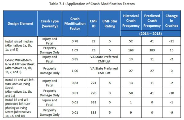
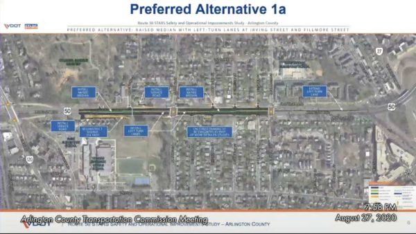
VDOT’s preferred alternative consists of a wide median from Glebe Road to Fillmore Street, the creation of dedicated left turn lanes at Irving Street, the extension of the westbound left-turn lane at Fillmore Street and the addition of dedicated left-turn phasing (green arrows) at Irving Street to service those new dedicated turn lanes.
VDOT’s report shows that, had these improvements existed from 2014 to 2018, there would have been 16 fewer crashes with injuries or fatalities. So, the fact that we’re waiting for these improvements until 2026 or 2028 means we can expect between 24 and 32 additional, preventable crashes with injury or fatality in the meantime.
However, all of the listed design elements from their preferred alternative, except for the extension of the westbound left-turn lane at Fillmore Street can be implemented within the existing roadway simple by narrowing some lanes to 10′ (within the Arlington County standard) and by repurposing some of the existing shoulder. A narrow median could be added with jersey barriers or a similar material, the dedicated left turn lanes striped in by repurposing excess lane width and some of the existing shoulder, the dedicated signal phases could be added at Irving Street. This would gain us 87% of the safety gains of the full project, while avoiding the slow and costly widening that VDOT is calling for which will cut down trees, add 2 acres of impervious surface, and reshape this stretch of Arlington Blvd into a defacto limited access highway.
The grant application was opposed by a number of nearby neighbors concerned that it would lead to additional cut-through traffic on Irving Street and I submitted and presented a letter for Arlington’s Transportation Commission for the reasons outlined above. Unfortunately, only one member of the County Board (Takis Karantonis) found the slow pace of implementation and large cost of VDOT’s preferred alternative unacceptable and so the grant application has been endorsed, leaving little incentive for VDOT to make interim safety improvements. The result: a project that costs more money and results in more crashes, injuries and potentially even fatalities.
Bizarrely, this safety study is a result of a program called “Strategically Targeted Affordable Roadway Solutions” (STARS), a program that would appear geared toward finding quick, cheap solutions to safety problems. Instead, it appears to be yet another vehicle for VDOT to push forward large, slow, expensive roadway widenings wrapped in the veneer of a safety study.
Chris Slatt is the current Chair of the Arlington County Transportation Commission, founder of Sustainable Mobility for Arlington County and a former civic association president. He is a software developer, co-owner of Perfect Pointe Dance Studio, and a father of two.
 Modern Mobility is a biweekly opinion column. The views expressed are solely the author’s.
Just in time for the start of the normal busy season in the D.C. area, MetroRail, MetroBus and ART have largely resumed normal levels of service. If you need to return to the office, transit is likely there and ready for you and the newest research is finding that riding transit can be done very safely.
MetroRail Service
MetroRail has returned to near pre-pandemic levels of service and most stations that were closed for platform reconstruction have re-opened, including East Falls Church. Dunn Loring and Vienna are set to reopen next week. Masks are required and customers are encouraged to socially distance to the extent possible.
MetroBus Service
MetroBus service ramped back up on Aug. 23 to about 75% of normal weekday service. Weekend service is back to 85-90%. Masks are required, customers are encouraged to socially distance to the extent possible, and boarding is through the rear doors to lessen bus driver exposure; bus fare collection is suspended.
ART Service
Most ART routes have returned to normal service with just routes 31, 61, 62 and 74 remaining out of service. Masks are required, customers are encouraged to socially distance to the extent possible, and boarding is through the rear doors to lessen bus driver exposure; bus fare collection is suspended.
Safety
The service has returned, but is it safe? Increasingly the answer appears to be “Yes”, that fear of public transit got ahead of the evidence. While we still have a lot to learn about this virus, public transit appears to not be a significant transmission vector.
France and Japan’s contact tracing efforts have found almost zero clusters linked to their public transit systems. A similar study in Austria was unable to link any of their 355 clusters to transit. Hong Kong, a dense city of 7.5 million people whose subway system was carrying nearly 13 million people per day saw and whose transit ridership dropped significantly less than other global systems has recorded only about 4,800 cases so far, or about a quarter of the number of cases seen in Prince William County here in Virginia — a county with a population of under 500,000 which is largely car-dependent. Read More
 Modern Mobility is a biweekly opinion column. The views expressed are solely the author’s.
On Friday, the County announced a new emergency ordinance prohibiting pedestrians from congregating on sidewalks in groups of more than three people or ever being less than 6′ apart from any other person.
Targeted quite plainly at young, mask-less patrons waiting in tightly-packed lines for long periods of time outside of Clarendon bars whose capacity has been limited by social-distancing requirements, the ordinance seems well-intentioned but flawed in concept.
The Ordinance
The ordinance, as released by the County states the during a state of emergency, “pedestrians shall obey signs and other signals erected on highways, streets, sidewalks, and public spaces adjacent thereto used by pedestrians prohibiting pedestrians from congregating in groups of four or more than four persons in those places and requiring pedestrians to maintain a physical separation from others of not less than six feet at all times.” I will note, however, that the verbiage about “and public spaces adjacent thereto” does not seem to exist in the language passed by the Board during the virtual board meeting.
Problems with the Ordinance
The ordinance appears to criminalize common behaviors: A plain reading of the ordinance would appear to prevent a family of four from walking down one of these signed sidewalks together without maintaining 6′ of distance between all family members, including small children.
The ordinance results in some very strange juxtapositions. Four people sitting at an outdoor dining table eating dinner, mask-less is not just legal, the County has adopted other emergency legislation to fast-track the creation of more outdoor dining space to encourage it. Those same four people, the exact same distance apart, but now standing on the sidewalk outside of a dining area are now all subject to a $100 fine. If those four now all climb into a car together, parked on the street in front of that same restaurant, they are legal again. Read More
 Modern Mobility is a biweekly opinion column. The views expressed are solely the author’s.
“Is it BRT if it doesn’t have dedicated lanes?” That was a hot topic of conversation in 2013 and I can’t finish out my series on Pike Premium Transit without digging back into the most controversial aspect of the Columbia Pike Streetcar debate.
If you need a refresher, Part 1 introduced what was envisioned for the Pike Premium Transit Network. Part 2 looked at progress on features to improve bus travel time. Part 3 examined the planned convenience & dependability features. Today, I’ll take a look at the most controversial feature that was ever discussed for Columbia Pike’s transit system.
What’s the point of dedicated transit lanes?
Dedicated lanes are a core feature of the best transit systems, no matter the mode. Given that your bus or train needs to stop places that aren’t your personal destination, transit systems can only be time-competitive with cars if they have a way to make up some or all of that time – like by not having to sit in the traffic created by those cars.
Why weren’t they planned for the Streetcar System?
Why wasn’t a dedicated lane recommended for the Columbia Pike Streetcar or the Premium Bus network that is replacing it? The first reason, is that it was seen as impossible at the time. During the first Alternative’s Analysis, VDOT was in control of Columbia Pike and made it clear they would never approve a reduction in the number of available through travel lanes of traffic. During the second Alternative’s Analysis, Arlington had gained control of Columbia Pike (except for the intersection with Glebe Rd and the interchanges with Route 27), but the agreement between Arlington and Virginia stipulated that Virginia would withhold maintenance funds for the entirety of Columbia Pike if it were reduced to fewer than two through travel lanes in each direction except during temporary lane closures related to construction, repair and maintenance.
What’s changed?
That agreement, however, is no longer in effect. It was amended in 2017 and would now allow a lane in each direction to be dedicated to only transit, or transit and HOV, or some other prioritization. So now that it technically possible, should we do it?
One of the earliest transportation analyses that was done for the Pike (in 2003) actually looked at several possible configurations for transit on the Pike:
- Curb Shared – transit operates in the curb lane and shares space with cars.
- Median Shared – transit operates in the median lanes (moving transit stops to the median) and shares space with cars.
- Curb Varies – transit operates in the curb lanes. It shares space with cars east of Taylor Street and new dedicated transit lanes that would be built in addition to the existing car lanes West of Taylor.
- Median Varies – same as Curb varies, but transit in the median lanes.
- Curb Exclusive – the existing curb lanes are dedicated to transit, all car traffic consolidated to the median lanes.
- Median Exclusive – the existing median lanes are dedicated to transit, all car traffic consolidated to the curb lanes.
The results?
A small improvement in travel time for transit over the “no-build” scenario (which already accounts for the rest of the improvements we’ve looked at – off-vehicle fare collection, all-door boarding, etc.) and a major increase in travel time for cars. Unfortunately, the study in question doesn’t ever calculate “person-throughput” or “per-person travel time” which are metrics that would clearly quantify the overall effect on travelers in the corridor, but with the effect on car traffic so much higher than the effect on transit and knowing transit ridership, while high on the Pike, is not more than 50% of travelers, it’s clear the overall effect is negative.
 Modern Mobility is a biweekly opinion column. The views expressed are solely the author’s.
As Northern Virginia prepares to enter Phase 2 and our community businesses and organizations begin to look for ways to safely resume activities, I have noticed a distributing trend — the use of cars as required Personal Protective Equipment.
The first time it caught my eye was Arlington’s drive-through COVID testing site that opened in March, offering convenient testing for any citizen… as long as they own a car. Thankfully the County recognized the inherent injustice in this arrangement and opened a walk-up testing site, though unfortunately not until nearly two months later. Sadly, other local organizations don’t seem to have taken this lesson to heart.
My children’s elementary school, Fleet, recently had a pick-up and drop-off day where families could pick up remaining items that were left at school when the COVID closure hit, as well as drop-off library books and other items. The logistics of this event were entirely built around the idea that everyone had a personal automobile.
No directions were given about how to drop-off or pick-up without a car and parents were warned in bolded and underlined letters that they were to stay in their car at all times. This despite Fleet having a sizable walk and bike to school rate.
DO READ Today's "FLEET BEAT" for Student Supply PICK UP/DROP OFF by Last Name (Library Books, Musical Instruments & Meds, etc.) MON. JUNE 8th (A-M from 9 – 12 PM & N-Z from 1 – 4 PM)! #FleetES @APSFleetPTA @Principal_Fleet @Fleet_AP @MsRothMusic @FleetLib pic.twitter.com/9hlTiH8VFJ
— Donleigh Honeywell (@APS_FleetES) May 29, 2020
Finally, the Ballston BID has recently announced a Retro Drive-in Movie Night. While less egregious than the above examples since it is purely for entertainment, it also stands out due to the demographics of Ballston. In a neighborhood where less than 40% of household drive alone to work and more than 16% are car-free, the BID has chosen to hold an event that requires a car to participate.
Likely none of the above organizations were trying to exclude anyone. Some may have been driven primarily by fear of the virus, others are certainly just suffering from what is known as “windshield perspective.” When you so often view the world from behind the wheel of a car, not only do you begin to implicitly assume that everyone owns a car, but it also colors your perceptions of people, places and events.
Research in 2013 found that not only do people who drive through less-affluent neighborhoods view them more negatively than people who walk, bike or take transit through the same neighborhoods, they even viewed the exact same event differently.
Participants in the study were shown one of four versions of a video of an ambiguous event (two boys fighting over a piece of paper). The only difference between the videos was that they were shot from either the perspective of a driver, a bus rider, a cyclist, or a pedestrian. Researchers found the participants shown the video from the driver’s perspective rated the actors higher on negative characteristics (threatening, unpleasant, etc.) than those shown the other videos.
If we are to meet our climate goals, we must make our transportation sector more sustainable. While electric vehicles can help, they aren’t enough. We need to be increasing the number of trips made via less carbon-intensive, not bowing to our windshield perspective and allowing COVID to push us in the direction of more cars.
Chris Slatt is the current Chair of the Arlington County Transportation Commission, founder of Sustainable Mobility for Arlington County and a former civic association president. He is a software developer, co-owner of Perfect Pointe Dance Studio, and a father of two.


