

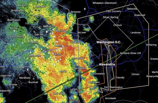
A line of strong storms with gusty winds and frequent lightning will soon be arriving in Arlington.
The storms have prompted a Special Weather Statement from the National Weather Service, for wind gusts in excess of 40 mph.
More from NPS:
Special Weather Statement
National Weather Service Baltimore MD/Washington DC
708 PM EDT Thu Aug 6 2026District of Columbia-Central and Southeast Montgomery-Prince Georges-Fairfax-Arlington/Falls Church/
…A LINE OF STRONG THUNDERSTORMS WILL AFFECT THE DISTRICT OF COLUMBIA…SOUTHEASTERN MONTGOMERY…CENTRAL PRINCE GEORGES… ARLINGTON…AND EASTERN FAIRFAX COUNTIES…THE CITY OF FALLS CHURCH AND THE CITY OF ALEXANDRIA…
At 707 PM EDT, radar indicated strong thunderstorms were located along a line extending from near Great Falls to Lincolnia to near Woodbridge. Movement was northeast at 40 mph.
Winds in excess of 40 mph are possible with these storms.
Locations impacted include… Arlington, Alexandria, Bethesda, Annandale, Clinton, Springfield, College Park, Fort Washington, Greenbelt, Langley Park, Beltsville, Fort Hunt, Groveton, Forestville, Falls Church, Huntington, Largo, Coral Hills, Bladensburg, and Fort Belvoir.
This includes Interstate 95 in Maryland between mile markers 1 and 28.
Torrential rainfall is also occurring with these storms, and may cause localized flooding. Do not drive your vehicle through flooded roadways.
Frequent cloud to ground lightning is occurring with this storm. Lightning can strike 10 miles away from a thunderstorm. Seek a safe shelter inside a building or vehicle.
