After last night’s strong storms that knocked out power to more than 5,000 homes and businesses, more stormy weather might be on the way.
The National Weather Service has issued a Severe Thunderstorm Watch for Arlington and much of the region.


After last night’s strong storms that knocked out power to more than 5,000 homes and businesses, more stormy weather might be on the way.
The National Weather Service has issued a Severe Thunderstorm Watch for Arlington and much of the region.

Update at 11:15 p.m. — The number of outages in Arlington is now down to 2,655, according to Dominion.
Update at 9:35 p.m. — About 4,000 Dominion customers are still in the dark in Arlington. Power was restored to more than 1,000 homes and businesses over the past three hours.

Arlington County will be under a Heat Advisory on Wednesday afternoon and an Excessive Heat Watch for Thursday afternoon.
The National Weather Service said today that high temperatures and humidity will reach dangerous levels as the week goes on. Heat index values of 105-110 degrees are possible on Thursday.
(Updated at 3:10 p.m.) It’s overcast and muggy right now, but it could be stormy later today in Arlington.
A strong storm toppled trees and knocked out power to more than 2,000 homes and businesses last night in parts of Arlington — primarily around the East Falls Church area — and another round of severe weather is possible later this afternoon and evening.

Update at 11:05 p.m. — Dominion is currently reporting 2,050 customers without power in Arlington, mostly in northern and western parts of the county. More than 19,500 customers are also without power in Falls Church and Fairfax County after the powerful storm.
Wow! A short but powerful storm w/ lots of lightning strikes & strong winds left 20,000 @DominionEnergy NoVa customers in the dark!

A Severe Thunderstorm Watch was just issued for Arlington and parts of the D.C. area.
Arlington, Alexandria, Falls Church and Fairfax County are among the Northern Virginia locales under the watch, which is in effect until 8 p.m.

Update at 1:50 p.m. — In addition to the Flash Flood Watch, a Severe Thunderstorm Watch was just issued for the area. Damaging winds, hail and torrential downpours are possible, forecasters say.
Severe Thunderstorm Watch in effect until 11 PM. Main risk is damaging winds. pic.twitter.com/gVYqxvoZed

Some strong storms are possible this afternoon and evening, forecasters say.
The scattered storms could pack damaging winds, potentially downing tree limbs and power lines. A Severe Thunderstorm Watch is possible, the National Weather Service says. Arlington is near the western border of the likely watch area.

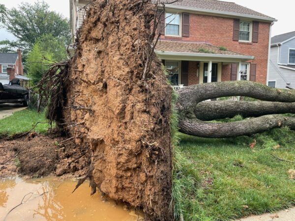
(Updated at 9:30 p.m.) The National Weather Service has confirmed that a tornado caused the widespread damage seen in several North Arlington neighborhoods today.
The tornado struck around 9 p.m. Thursday night, touching down near the intersection of Lee Highway and N. Glebe Road. It was rated as an EF1 — the second-lowest on the Enhanced Fujita scale — and cut a 125 yard-wide path of damage as it made its way east through several neighborhoods, before moving into D.C. Maximum winds were estimated at 90 mph.
Update at 4:15 p.m. — The earlier severe thunderstorm watch and warning have both been cancelled.
Update at 3:40 p.m. — Just over 1,400 Dominion customers in Arlington are without power, according to preliminary numbers from the power company’s website.

Northern portions of Arlington County are now under a Severe Thunderstorm Warning.
A line of strong storms is approaching the area and may pack damaging wind gusts.
Update at 5:10 p.m. — A Severe Thunderstorm Warning has now been issued.
Update at 2:20 p.m. — A Severe Thunderstorm Watch has now been issued for Arlington and much of the region.