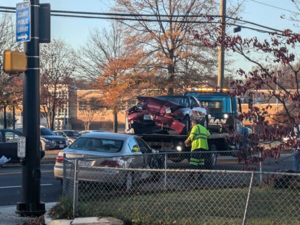
Arlington County has converted two intersections near Nottingham Elementary to four-way stops, in the wake of last year’s fatal crash on Little Falls Road.
In October, a driver struck and killed a woman at the intersection of Little Falls and John Marshall Drive. She was the third pedestrian killed along a two-block stretch of Little Falls Road near the school over the past eight years.
In the aftermath, the county began investigating the appropriateness of an all-way stop at the intersection.
Two such traffic patterns were installed along Little Falls Road in mid-March, Dept. of Environmental Services spokeswoman Katie O’Brien says: one at the intersection with John Marshall Drive and the other with N. Ohio Street.
“The two new all-way stop locations are located on both sides of the Nottingham Elementary School and help facilitate crossing opportunities for pedestrians and traffic control on this section of roadway,” O’Brien said. “Additional pavement markings and tactical improvements were made at the intersection of Little Falls Road and N. Nottingham Street.”
Last winter, as part of a traffic safety campaign, the county temporarily ramped up traffic enforcement on Little Falls Road, which saw two previous fatal crashes in 2014 and 2019.
Then, with the urging of the County Board to make safety improvements faster, it made some other short-term updates to the two intersections, says O’Brien.
The all-way stops were deemed necessary after multiple observations and on-site reviews to “assess the operations and effectiveness of the recent short-term improvements,” the spokeswoman said.

In another step to increase safety, last week the county reduced speeds near Nottingham. It made the area around the school a “School Slow Zone,” where there is a permanent 20 mile-per-hour speed limit on a neighborhood street within 600 feet of a key access point to a school.
Earlier this week, meanwhile, at the intersection of N. Quincy Street and 9th Street N. in Ballston, an all-way stop was added in response to an extensive study and data collection effort. Pavement markings will follow soon, says O’Brien.
Safety concerns at this intersection date back more than a decade. The county has added upgrades incrementally to the originally sign-free intersection, Google Maps shows.
By 2010, ARLnow previously reported, a crosswalk and “yield to pedestrians” flags were added. Then, the county added neon yellow pedestrian signs and a repainted crosswalk.
O’Brien says the county studied whether to add stop signs given the limited impact of previous upgrades and repeated safety concerns from residents who cited the high volume of traffic at the intersection.
“This most recent study’s conclusion at this location reflects further consideration of the travel volumes and crash history at this location,” O’Brien said. “It also is part of our Vision Zero approach to safety intervention that calls for a progressive method on implementing safety measures when past efforts do not result in the desired outcomes.”
(Updated at 12:20 p.m.) A troubled intersection near Lubber Run Community Center clocked another vehicle crash last week.
The collision at N. George Mason Drive and N. Park Drive last Tuesday happened as neighbors await the installation of street markings and, eventually, signage, alerting drivers to a lower speed limit of 20 mph in the area.
“A Porsche SUV gunned it through a busy intersection and collided with another SUV,” said Phillip Berenbroick, who saw the crash. “[It] happened right as kids and parents are rushing over to Barrett Elementary [School] for 9 a.m. school start.”
And that wasn’t all. While first responders were still on scene, an Audi SUV headed from the Arlington Forest neighborhood toward Ballston on Park Drive sped through the intersection and was pulled over by police, Berenbroick said. He noted that Rectangular Rapid Flashing Beacons stopping traffic and allowing pedestrians to cross N. Park Drive were flashing.
“It’s super dangerous for pedestrians when cars traveling eastbound on Park Drive out of Arlington Forest try to cross through the intersection and turn northbound on George Mason,” he said. “ACPD pulled the car over and let the driver off with a warning. It was a little surprising since the accident that police and EMTs were responding to was a result of the same type of dangerous driving.”
The collision reignited one neighbor’s push for a traffic signal there, particularly given the presence of Barrett Elementary one block away. Drivers tend to go fast on the four-lane expanse of N. George Mason Drive, leaving few windows for people on N. Park Drive trying to cross or turn left, including those going to and coming from the popular Lubber Run Community Center.
Arlington has a county-wide policy setting a permanent 20 mph speed limit on neighborhood streets within 600 feet of a school. Arlington County expects markings alerting drivers will cost $150,000 and will be added over the next 2-3 years.
Another crash and N. Park and N. George Mason, this morning, this time witnessed by kids walking to school and a child was in the car that was struck. Still debating a light @ArlingtonVA or waiting for kids to get injured? @ARLnowDOTcom pic.twitter.com/LKc4fn6BzX
— David (@Dhartogs) March 29, 2023
Rectangular Rapid Flashing Beacons, which give pedestrians are more “protected” window to cross the road, were installed at the N. Park Drive intersection in late 2020 as part of a transportation study related to the community center project.
Currently, the speed limit on N. George Mason Drive in the area is 30 mph, reduced to 25 mph when a light near the community center is flashing. Later this spring, speeds on the road will drop another 5 mph — to 20 mph — when lights are flashing, in response to a new county-wide policy.
As part of the updated school zone policy, the speed limit on parts of Park Drive near Barrett will be reduced to 20 mph at all times.
Also this spring, the intersection is expected to get new “SLOW SCHOOL XING” markings after it is repaved, according to Dept. of Environmental Services spokeswoman Claudia Pors.
“The Water Sewer Streets crew is putting together the schedule for what streets are getting repaved this season, so the timing of when the N. George Mason Drive and Park Drive [intersection gets] paved will depend on them,” said Pors.

In all, there have been 23 crashes at George Mason sand Park since 2017, of which nine occurred in the two years the Lubber Run Community Center has been open, according to data from Arlington County Police Department. Last week’s crash does not register because it does not reporting criteria outlined in state code.

Lower speeds near schools could soon become countywide policy in Arlington.
On Saturday, the Arlington County Board is set to consider an ordinance to lower speed limits to 20 miles per hour on streets within 600 feet of a school property or pedestrian crossing in the vicinity of the school. This would expand on slow zones around 13 schools instituted last year.
The county says in a report that the proposed slow zones respond to positive community feedback from the first round of school zones and are part of its efforts to eliminate traffic-related serious injuries and deaths by 2030, also known as “Vision Zero.”
The ordinance comes as Arlington County appears to have ended 2022 with fewer severe injury crashes than 2021 — when the County Board approved a Vision Zero plan — but the same number of fatal crashes.
In 2022, there were 44 severe and four fatal crashes, including two fatal pedestrian-involved crashes, per county data available through Nov. 23, 2022. The year before, there were 61 severe and four fatal crashes, none of which involved a pedestrian.
If approved, the Dept. of Environmental Services will lower the speed limit on 36 road segments starting next month, according to spokesman Peter Golkin.
“We expect signs to start posting the new speed limit in February-March,” he said. “We will follow up with additional pavement markings in the spring once weather permits.”
When complete, drivers will notice treatments such as high visibility crossings and school zone signage within the school zone, as well as appropriate speed limits on the school’s beaconed arterial roadways, per a December Vision Zero newsletter.
The new, lowered speed limit of 20 mph, applicable at all times of day, will be in effect and enforceable “as soon as the new speed limit signs are posted,” Golkin said.
To remind drivers of the change, the county will send public announcements during February and March through county email lists, civic associations, APS channels and social media, he said, noting that “news coverage like ARLnow’s will also be a great help.”
In addition, he said, the signs themselves will be a notification.
“Drivers should always be cognizant of the speed limit when driving,” the DES spokesman said. “They also have a bright neon yellow SCHOOL symbol on top of them, which should generate extra attention.”
The Arlington County Board last year took another step to reduce speeds, approving the installation of moveable speed cameras in school and work zones. In response to a rash of critical crashes, including a fatal pedestrian fatally struck near Nottingham Elementary School in October, Board members put more pressure on staff to respond more quickly.
Around where the pedestrian was struck on Little Falls Road, Arlington County police issued 10 traffic ticket in one hour during a one-day enforcement effort last month. Also in mid-December, some “quick-build” improvements were installed along the road, between John Marshall Drive & N. Kensington Street, per the December Vision Zero newsletter, below.
The improvements at John Marshall Drive include:
- Addition of a high visibility crosswalk on the south crosswalk
- Tactical curb extensions to sharpen/slow down turning vehicle turns and reduce crossing distances
- Additional signage
Improvements at N. Lexington Street include:
- Bus stop/sharrow markings
- High visibility crosswalks
- A tactical curb extension to sharpen/slow down turning vehicle turns and reduce crossing distances.
Improvements at N. Kensington Street (north side) include:
- High visibility crosswalks
- Tactical curb extensions to sharpen/slow down turning vehicle turns and reduce crossing distances
- Enhanced signage at the crossing over Little Falls Road
- Changing the yield to a stop sign (south side)
These improvements are currently in progress and will ultimately encourage slower vehicle speeds, and improved pedestrian and transit maneuvers.
Additionally, DES is conducting an all-way stop evaluation and is collecting footage of the Little Falls Rd and John Marshall Dr intersection to monitor operations between all road users. These evaluations will be considered as DES plans for permanent intersection improvements.


Arlington is proposing to lower speed limits near schools across the county to 20 mph as the county’s second year of Vision Zero enters the rear-view mirror.
This Saturday, the Arlington County Board is set to hear a proposal to expand these slow zones to all schools, after many people said they felt safer walking, biking and driving in 13 school zones where the speed limit has already dropped to 20 mph.
If the Board approves the changes, school zones will all get permanent signs with the new speed limits. The county says this is cheaper and more broadly applicable than flashing beacons, which will only be used on arterial streets within 600 feet of schools during arrival and dismissal times.
This change follows the approval earlier this year of moveable speed cameras to be installed in school and work zones, as well as calls from the Arlington County Board for a quicker staff response to critical crashes, after a driver fatally struck a pedestrian in an intersection near Nottingham Elementary School.
Schools have figured into other notable crashes, including a fatal crash involving a motorcyclist and a school bus in front of Drew Elementary in 2021 and a crash involving a drunk driver who killed a pedestrian near Thomas Jefferson Middle School this summer. In a less serious crash this fall, a driver struck an adolescent cyclist near Kenmore Middle School.
Lowering speeds is one action the county has taken over the last year and a half to work toward its goal of eliminating traffic-related fatalities and serious injuries by 2030, a plan known as Vision Zero.
“There are no corridors on county-owned roads that have a speed limit higher than 30 miles per hour, which is a big improvement. We’re very excited to say that,” Arlington Vision Zero coordinator Christine Sherman Baker said in a meeting last week.
In addition to lower speeds, the county has set up temporary school walking routes and roundabouts, completed 13 quick-build projects and made improvements to six critical crash sites and 14 crash “hot spots.” Staff are working on procuring speed cameras for school and work zones and red light cameras for six more intersections, which could be installed in 2023.
Amid the flurry of work, preliminary data from the first nine months of 2022 indicate crashes are down overall, according to a Vision Zero report released last month. As of Aug. 30, there were 1,313 crashes in Arlington, of which two were fatal and 34 were severe. (We’ve since reported on two additional fatal crashes.)

Pedestrian-involved crashes and crashes in intersections are both slightly lower, while bike crash figures are consistent with previous years. There has yet to be a crash in a work zone.
“Alcohol and speed prove to be some of our biggest challenges on our roadways,” Baker said in the meeting.
But some people say the county needs to be clearer in communicating if and how its work is reducing crashes as well as the dangers of driving.

Arlington County has not ruled out the possibility of a permanent roundabout on Military Road despite the confusion a temporary version has caused for the past year.
In October 2021, where there used to be a stop sign for traffic on northbound Military Road, the county added paint lines, bollards and raised temporary curbs, and partially demolished a median. The work was aimed at improving safety where Military Road intersects with Nelly Custis Drive.
While preliminary data from the county found the roundabout did lower speeds, 53% of drivers, 27% of pedestrians and 26% of cyclists said they felt “less safe” or “much less safe” using the new traffic pattern, per a summary of feedback collected this summer.
“The majority of all respondents reported feeling less safe while using the pilot intersection, but the margins were very narrow for those who walked or biked through the intersection,” the report says. “Those who reported feeling less safe highlighted concerns with operational confusion, the size of the pilot roundabout and the perceived lack of sufficient space for a well-designed roundabout in the future condition.”
Drivers said they were confused about proper procedure in the intersection, while cyclists said drivers exhibited inconsistent behavior and would revert to habits they had when the intersection had a stop sign, per the report. Additionally, several users said the temporary materials caused visual challenges that contributed to the confusion.

About 31% of drivers, 26% of pedestrians and 18% of cyclists said they felt “safer” or “much safer” with the traffic circle, the summary says.
Road users in this camp were also concerned about confusion, but “reported better yield rates by vehicles to pedestrians, slower vehicle speeds, and easier operations for traffic flow and left turns from Military to Military,” the report said.
For now, it seems the roundabout is still in play as a permanent change.

The report says that the project can “take the form of either a signalized intersection or a roundabout” and that a majority of issues locals raised “can be addressed through design in a capital project, where the intersection design will not be limited by existing curb lines.”

Meanwhile, the Old Glebe Civic Association, which previously called the changes “unwanted” and says it has opposed the potential project for four years, says it has sources claiming the roundabout is all but a done deal.
“Two County staff members recently stated that the County will be building a permanent roundabout, which will take about 12 to 15 months, independent of the public feedback,” writes Peter Jaffe in the October edition of OGCA’s newsletter. “They said that the permanent roundabout will be larger than the temporary one and that the increased size will help address confusion by drivers about who is in the roundabout and who has the right of way.”
The report notes that recently, signs in the middle of the roundabout “have been knocked down and later repaired at least twice, suggesting that incidents have occurred at the roundabout.” The Old Glebe neighborhood is about 2 miles west of the roundabout, but Military Road is a popular commuter route for those heading east.
In response to OGCA’s letter, Dept. of Environmental Services spokeswoman Claudia Pors tells ARLnow there is no official recommendation yet.
“The County has not shared any recommendation or decision for the Military Road and Nelly Custis Roundabout Pilot Project at this time,” she said.
As for the signage, she said the team at DES is aware of the issue.
“Throughout the pilot’s duration, signage has been knocked over,” she said. “Staff has repaired or replaced these signs as soon as possible. We do not have information on the exact causes of these incidents or how many times they occurred.”

While Fairfax County mulls installing speed cameras, it may be some time before locals see speed cameras go up in Arlington.
In January, the Arlington County Board approved their installation in school and work areas to reduce speed-related crashes in these areas. The move is part of its Vision Zero campaign to eliminate traffic fatalities and injuries.
The Board made its move after the Virginia legislature allowed municipalities to install them in these locations in 2020.
But the Arlington County Police Department is still working on finding a vendor to implement the cameras, says Dept. of Environmental Services spokeswoman Katie O’Brien.
“ACPD is in the process of launching a procurement for a vendor, which is estimated to wrap up in spring 2023,” she tells ARLnow.
Once a vendor is chosen, the pace toward implementation could speed up. O’Brien says the county will have a better idea of where the cameras will go and when they’ll be installed “once vendor procurement is complete.”
The same is true for community updates.
“We will begin further community outreach and education once we are closer to procuring a vendor and beginning implementation, which will likely be in spring 2023,” she said.
Camera locations have not yet been chosen, said O’Brien. But Arlington schools have been close to a number of notable crashes, including a fatal crash involving a motorcyclist in front of Drew Elementary School, a fatal crash involving a pedestrian and a driver near Nottingham Elementary School, a fatal pedestrian crash near Thomas Jefferson Middle School, and a less serious crash involving a cyclist near Kenmore Middle School.
Locations will be chosen based on guidelines that DES has worked on with a consultant. That effort, funded by a Metropolitan Washington Council of Governments grant, is wrapping up, O’Brien said.
“The County (ACPD, APS, and DES) will then collaborate to refine and finalize specifications and guidelines, using the information from the grant project combined with local needs and knowledge,” she said.
Future progress, such as approving the vendor or camera locations, won’t need County Board approval, O’Brien said.
Once installed, cameras will identify and ticket speeding vehicles using radar, and police officers review footage to confirm the speeding violations. Tickets will be issued by mail to drivers traveling at least 10 mph over the speed limit, per state law.
The tickets will cost $50 and won’t result in a points reduction on your driver’s license or impact insurance rates.
“Speed camera fines are intended to encourage people to drive the speed limit,” the county says. “Fines do not generate revenue for police or transportation programs. Rather, fines issued will be distributed to the County’s General Fund. Therefore, there is no incentive to use speed cameras to fund department budgets.”
Community engagement is not set to begin until spring 2023. Previous outreach conducted as part of Arlington’s Vision Zero initiative, which reached more than 1,000 community members, indicated support for the cameras, according to the county.
Likewise, some supported speed cameras during online forums facilitated by Arlington’s Police Practices Work Group, as a way to reduce race- and ethnicity-based disparities in traffic enforcement.
Drunk driving — the alleged reason why a woman was killed in a hit-and-run last month — is on the rise in Arlington.
The fatal crash in the Arlington Heights neighborhood has county leaders considering greater emphasis on curbing drunk driving. Neighbors, meanwhile, are asking the county to add more traffic calming measures to combat risky driving, particularly near Alice West Fleet Elementary School and Thomas Jefferson Middle School.
On Aug. 1, a driver hit Viviana Oxlaj Pérez while she was walking near the Thomas Jefferson Community Center at 3501 2nd Street S. She was treated at the scene and transported to the hospital, where she died.
The Arlington County Police Department arrested Julio David Villazon at his home on Aug. 2 and charged him with involuntary manslaughter, hit and run, driving under the influence and driving on a revoked license.
There has been an uptick in alcohol-involved crashes in Arlington. Last year, ACPD recorded 143 alcohol-involved crashes, up nearly 49% increase from 96 in 2020, according to its 2021 annual report. In 2022, ACPD has recorded 116 alcohol-involved crashes, says police spokesman Ashley Savage.

Driving under the influence is one of the top contributing factors to a “disproportionate” number of critical and fatal crashes in the county, says Dept. of Environmental Services spokeswoman Katie O’Brien. The others are speeding, turning left at an intersection, turning right across bicycle lanes and failing to yield to pedestrians.
Each of these behaviors is being addressed during an ongoing “Critical Crash Mitigation Campaign” through December.
The recent rise in alcohol-related crashes chips away at what had been a broader downward trend in drunk driving. Arlington County Board Chair Katie Cristol attributed this initial decrease to efforts, such as the ACPD Arlington Restaurant Initiative and the Washington Region Alcohol Program, as well as the growing popularity of ride-sharing services — which have been getting more expensive.
“Now, however, national trends are indicating major increases in alcohol-related traffic fatalities during the pandemic (regional data is lagging but reasonable inference suggests our local trends may be similar),” Cristol said in an email to ARLnow. “This indicates to me that there is a greater role for the County Board in public education about the threat that drunk driving poses to our own community.”

Cristol said the most important message she can communicate about last month’s crash is that “there is no safe way to drive drunk.”
“In this situation, the driver was impaired, and there is no ‘safe’ BAC above zero to get behind the wheel. Any intersection or roadway — irrespective of the physical safety improvements, visibility interventions, or other designs to the built environment — is unsafe when a drunk driver is present,” she said.
The DUI is Villazon’s second driving offense within the last 10 years, according to court records. He was previously found guilty of “improper driving” in the Arlington General District Court. Under state code, the misdemeanor charge of reckless driving can be knocked down to improper driving if either the judge or the prosecutor find that the offense was not serious.
His next court date is in February 2023.
The crash that killed Oxlaj Pérez is being examined by a broad swath of local agencies, including Arlington’s transportation staff, the police and fire departments, Arlington’s Dept. of Human Services, Virginia State Police and the County Manager’s office.
But neighbors say the problem is not hard to understand. They say drivers, particularly during school drop-off and pick-up times, speed down S. Glebe Road and Arlington Blvd (Route 50), run red lights, roll stop signs, make illegal U-turns, block crosswalks and go the wrong way on 1st Road S., a one-way street — and they’re not drunk.
“I understand the tragedy that occurred a few weeks ago involved alcohol and likely wouldn’t have been prevented with traffic changes,” said one neighbor, Kelly Cherry-Leigh Davison. “But we have brought up these safety issues numerous times to everyone we can think of and are getting nowhere. I’m worried every day another tragedy is going to occur and we could be preventing it.”
A longtime project to make pedestrian, cycling and transit upgrades to Army Navy Drive has taken the next step forward.
Arlington County has sent the project out for bidding by contractors, while staff continue to acquire the easements needed for construction.
“Project staff expect the easement process to be wrapped up by the time the construction contract appears before the County Board for approval — anticipated later this summer,” Dept. of Environmental Services spokesman Nate Graham said.
Construction could start this fall and be completed in the summer of 2025, according to the project webpage. Initially, the county had expected construction to begin in spring 2020 and be complete this spring, but extra tasks required to receive federal aid dragged out the planning process by a few years.
A coalition of local transit advocates celebrated the news, which has been seven years in the making.
The Army Navy Drive Complete Streets Project is officially out to bid! Many thanks to everyone who has worked to see this transformative project through over the last 7+ years! https://t.co/qSMXM7ioMD
— Sustainable Mobility for Arlington County (@susmoarlington) March 30, 2022
Crashes are a frequent occurrence along Army Navy Drive. The $16.87 million project aims to reduce conflicts among cars, buses, bikes and pedestrians with narrower lanes — to slow down vehicle traffic — as well as bus-only lanes, protected left turns and signalized right turns, clearer sidewalks and shorter crosswalks.
The south side of Army Navy Drive will have a two-way bike lane protected by a line of trees. This will link to a future two-way bicycle lane planned for S. Clark Street, between 12th Street S. and 15th Street S. and the planned protected bike lanes on S. Eads Street, which will run past both phases of Amazon’s HQ2.

“The project will rebuild Army Navy Drive within the existing right-of-way as a multimodal complete street featuring enhanced bicycle, transit, environmental and pedestrian facilities,” the county says. “The goal of the project is to improve the local connections between the Pentagon and the commercial, residential and retail services in Pentagon City and Crystal City.”
The new Army Navy Drive will be reduced to two through lanes in each direction, narrowing to one lane east of S. Eads Street.
The reduction will accommodate a bus lane between S. Joyce Street and S. Hayes Street so that buses will not block traffic while loading passengers. This dedicated transit lane will help extend an existing network of bus lanes from the City of Alexandria to Crystal City into Pentagon City.

Additional improvements include replacing raised medians with planted ones and planting greenery to reduce stormwater runoff. Five intersections will get new traffic signal equipment.
The project’s early phases kicked off in the summer of 2015 with a traffic analysis evaluating how biking, walking, scooting and driving conditions would be impacted in 2020 and 2040 by the ongoing redevelopment of Pentagon City and Crystal City. That has since been expedited by the ongoing construction of HQ2.
(Updated at 1:30 p.m.) There’s a new temporary traffic circle along Military Road aimed at improving safety where it intersects with Nelly Custis Drive.
Where there used to be a stop sign for traffic on northbound Military Road, the county has added paint lines, bollards and raised temporary curbs, and partially demolished a median. The work was completed Saturday, according to a spokesman with the Arlington Department of Environmental Services.
The one-lane roundabout at the intersection in the Donaldson Run neighborhood was completed after the county resurfaced Nelly Custis Drive as part of its annual street maintenance program.
“This pilot project, in conjunction with the Vision Zero transportation safety program, will test the effectiveness of a roundabout for improving pedestrian safety and reducing vehicle speeding at the intersection,” according to the county. “It will be in place for one year to allow data collection of real-world conditions, and since it’s temporary, it can be adjusted as needed or removed easily if it doesn’t work.”
The county will study traffic patterns to determine whether to keep the roundabout or install a lighted intersection, per a county webpage on the project.
“Military Road and Nelly Custis Drive intersection safety improvements will focus on driver yield rates, shortening crossing distances for people walking through the intersection, providing predictable turning movements [and] reducing vehicle speeding,” the website says.
Some neighbors are displeased with the new traffic configuration. An October newsletter from the Old Glebe Civic Association called the changes “unwanted.”
The civic association said it has repeatedly expressed its opposition to the potential project for four years, and it would like to see the old traffic pattern restored after the study.
“OGCA pledges continued opposition to the roundabout,” it said. “Other civic associations have concurred with OGCA that the project is overly expensive, will not improve traffic safety, and will unnecessarily slow movement along Military Road.”
Per DES data, about 11,000 vehicles pass through the intersection daily. In a presentation this summer, county staff said conversions to roundabouts reduce pedestrian crashes by 27%, and conversions from stop-controlled intersection reduce injury crashes by 82%.
But OGCA argues that crash data for the intersection doesn’t merit the change.
“In August, OGCA argued that the… construction cost was unjustified given little evidence of any safety concerns,” the newsletter continues. “Only three accidents have occurred over the past eight years (two involving bicycles) out of the approximately 32 million vehicles that passed through the intersection during that period. Our letter also said removal of the stop sign and bike lane increases danger for pedestrians — particularly school children during morning rush hour — and also for bicyclists.”
Bike lanes were converted to “sharrows,” or arrows reminding drivers to share the road with cyclists, per a planning document.

This is the last of three intersections — including those at Marcey Road and 36th Road N. — to be changed as part of a project aimed at improving safety along Military Road.
“These intersections were identified in a 2004 Arterial Transportation Management Study that suggested several recommendations to improve safety for all modes of transportation in the Military Road corridor,” according to DES.
Some local residents said in public comments that they supported the roundabout.
“As 25-year residents who live one block from this intersection and who walk, ride bikes, commute, and use the ART bus, we believe that a safer solution is needed due to excessive speed; drivers who fail to yield to pedestrians; and increased traffic volume,” said one couple.
The county website says the key takeaways for traveling through a roundabout are:
- Always yield to pedestrians and cyclists at the crosswalks
- When entering the roundabout, yield to vehicles and cyclists inside the roundabout
- Signal when exiting the roundabout
Arlington County’s transportation division is kicking off its ambitious plan to eliminate traffic deaths with a series of relatively quick safety projects.
For now, most of those projects appear to be in North Arlington.
Four months ago, the Arlington County Board adopted a five-year action plan that aims to eliminate traffic fatalities and severe injuries, known as “Vision Zero.” The plan lays out a systematic approach to safety improvements, addressing the most urgent needs through data analysis, equity and community engagement.
These improvements vary in scope: “quick-build projects” address immediate needs quickly using low-cost materials, while larger-scale projects require funding from the county’s Capital Improvement Program or grants. Others include pilot projects and regular maintenance work.
“We’re focusing initially on small-scale operational improvements… a small but important part of program,” said Dennis Leach, the director of transportation for the Department of Environmental Services.
Residents will see upgrades such as curb and median extensions, improved bus stops, curb-and-gutter repairs, new ramps and new high visibility crosswalks. DES has already completed eight “quick-build” projects and 11 are underway, according to its website.
Staff identify projects by analyzing crash data and considering reports by police, Arlington Public Schools and community members. They are constructed on a rolling basis.
For example, this month, staff completed a new mid-block crosswalk across N. Ohio Street that will improve access to Cardinal Elementary School and Swanson Middle School School. Staff are now installing a crosswalk with accessible curb ramps over Sycamore Street for better access to Tuckahoe Park and Tuckahoe Elementary School.
Of the 19 completed and under-construction projects, only three appear to be in South Arlington. One Twitter user mapped out the geographic spread of these projects, raising questions about how these projects are chosen and when DES will make its way south, given that equity is a core tenant of Vision Zero.
I mapped all of the @arlingtondes Quick-Build Vision Zero program projects in progress or completed. This is the primary program getting some extra paltry funding for safety.
— Car-Free HQ2 (@CarFreeHQ2) September 28, 2021
Um, notice any patterns?https://t.co/nYVzFq1Nw1 pic.twitter.com/zcznoZJ8Ru
Leach said that could be because there are a number of older community and school requests being worked through.
“I think there’s an issue of a pipeline of small projects that may have gotten their start in early years,” Leach said. “What you see in the pipeline of quick-build projects has been built up over years… These projects may have gotten their start before Vision Zero was adopted.”
Transportation and Operations Bureau Chief Hui Wang said these projects are “a very small, skewed piece of the transportation program” because they don’t show large-scale investments, such as those on Columbia Pike.
“When we’re talking about balance, equity, we have to make sure that we’re not looking at it through a shaded lens,” she said.
Leach agrees.
“[Columbia Pike] is our single largest focus areas, as it has some of our oldest infrastructure,” he said. “In other parts of the county, like the Rosslyn-Ballston corridor, private development builds a lot of the infrastructure. In Columbia Pike, until recently, there’s been little private development — there’s more now — but it’s been left to county to actually make those investments in advance of redevelopment.”
When asked if certain communities generate more traffic reports than others, Wang said DES doesn’t map out community reports because it’s hard to categorize them and her team doesn’t have the resources for that.
“My team is focused on the engineering part — our goal is trying to get things done,” she said.
The data-based approach helps weed out what is a perceived safety risk versus actual safety risks, Wang noted.
“We use crash data to identify real problems,” she said. “We’re using data as a guiding force, focusing on high-injury networks.”
Chris Slatt, who is president of transportation advocacy group Sustainable Mobility for Arlington County, said it’s not surprising that initial projects will skew toward North Arlington.
“Complaint-driven processes are well-known to reflect the biases of whom within the community is best equipped to spend precious time and energy complaining, so we would fully expect that method of identifying projects to skew toward the more affluent areas of Arlington unless staff works intentionally to correct that bias,” he said.
After five years, Arlington County is putting finishing touches on its Complete Street plan to improve walking, biking and driving conditions along a stretch of Army Navy Drive in the Pentagon City area.
The updated plans — which are 90% complete — were presented in a virtual public hearing on Wednesday. County staff are taking public comments via email on this version until Dec. 4, and the final plans will be submitted next summer. Construction on the section of road from S. Joyce Street to S. Eads Street is slated to begin in 2022.
The $16.87-million project aims to reduce conflicts among cars, buses, bikes and pedestrians with narrower lanes, stretches of bus-only lanes, protected left turns and signalized right turns, clearer sidewalks and shorter crosswalks. The south side of Army Navy Drive will have two-way bike lane protected by a line of trees.
“A lot of the signalizations will improve safety, prevent fatalities, reduce collisions, things like that,” Jon Lawler, the project manager, said during the meeting.
Crashes happen frequently in its intersections: Staff said the S. Hayes St/I-395 off-ramp intersection had the second-most collisions of any Arlington intersection in 2016.
The measures mean the new Army Navy Drive will be reduced to two through lanes in each direction, narrowing to one lane east of S. Eads Street.
“This segment has much lower traffic volumes than the other four blocks of the project corridor,” Lawler said in an email.
Reducing a lane of traffic to accommodate a bus lane between S. Joyce Street and S. Hayes Street will actually improve flow because buses will not block traffic while loading passengers, he said.
Traffic lanes will be narrowed to slow down cars, but staff are not planning to propose a lower speed limit, which is 35 miles per hour, Lawler said during the meeting.
Construction is still a ways off. Staff expect construction to begin in the spring of 2022. With work scheduled block by block to minimize disruptions, it could last until the fall of 2024. Original plans had construction starting in 2020 and ending in 2022.
Lawler attributed the delays to the additional tasks needed for a project receiving federal aid.
“For this project, it took much longer to receive our National Environmental Policy Act document approval than we had envisioned,” he said in an email.
Staff skipped the 60% design phase to make up for lost time, he said.
After the medians are removed, work will start on the south side of Army Navy Drive, beginning with the area where Amazon HQ2 will be, along S. Eads Street, and moving west. Once the medians are replaced, the road will be repainted and striped, concluding the project.
Lawler said in the meeting that “we won’t have any conflict” with Amazon construction.
Community feedback led to two major changes, he said. First, another block of protected bike lane was added to connect the bike lane west of S. Lynn Street with the planned protected bike lane starting at S. Joyce Street.
“This way we don’t have a missing link in the system,” Lawler said in the meeting.
Staff could not insert this change into this project, as it is receiving federal funding, so they created a separate capital improvement project to address it, he said.
From S. Lynn Street — near Prospect Hill Park — to S. Eads Street, Army Navy Drive is “pretty uncomfortable to use scooters and bikes on,” Lawler told ARLnow after the meeting. “The changes will provide them a safer route for them to use.”
With the changes, bicyclists on Army Navy Drive will be able to use the major east-west link more easily to connect with the Mount Vernon Trail and get to Washington, D.C., he said.
Another change was to align the bumpy pedestrian ramps with the crosswalk. Initially, the ramps were perpendicular to the crosswalk, which advocates said directs vision-impaired pedestrians into harm’s way.