
Update at 6:50 p.m. — Nearly 1,000 Dominion customers are without power in Arlington, according to the utility company’s website. Most of the outages are in the county’s far northern neighborhoods along the border with McLean, which is experiencing widespread outages after the storms.
Update at 6:15 p.m. — A second line of storms is arriving and has prompted a second Severe Thunderstorm Warning, below, which is in effect until 7 p.m.
BULLETIN – IMMEDIATE BROADCAST REQUESTED
Severe Thunderstorm Warning
National Weather Service Baltimore MD/Washington DC
609 PM EDT Mon Jun 22 2026The National Weather Service in Sterling Virginia has issued a
* Severe Thunderstorm Warning for… The District of Columbia… Northwestern St. Marys County in southern Maryland… Prince Georges County in central Maryland… Charles County in southern Maryland… Arlington County in northern Virginia… The City of Falls Church in northern Virginia… Southeastern Fairfax County in northern Virginia… The City of Alexandria in northern Virginia…
* Until 700 PM EDT.
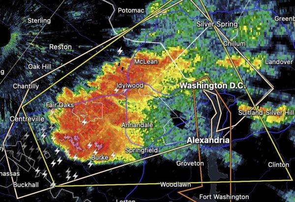
* At 609 PM EDT, severe thunderstorms were located along a line extending from Burke to near Stafford, moving east at 50 mph.
HAZARD…60 mph wind gusts.
SOURCE…Radar indicated.
IMPACT…Damaging winds will cause some trees and large branches to fall. This could injure those outdoors, as well as damage homes and vehicles. Roadways may become blocked by downed trees. Localized power outages are possible. Unsecured light objects may become projectiles.
* Locations impacted include… Arlington, Alexandria, Waldorf, Bowie, Annandale, Clinton, Springfield, Fort Washington, Fort Hunt, Groveton, Forestville, Falls Church, Huntington, Largo, Coral Hills, Bladensburg, La Plata, Fort Belvoir, Pimmit Hills, and National Harbor.
PRECAUTIONARY/PREPAREDNESS ACTIONS…
For your protection move to an interior room on the lowest floor of a building.
Large hail, damaging wind, and continuous cloud to ground lightning are occurring with these storms. Move indoors immediately. Lightning is one of nature`s leading killers. Remember, if you can hear thunder, you are close enough to be struck by lightning.
Torrential rainfall is occurring with these storms, and may lead to flash flooding. Do not drive your vehicle through flooded roadways.
Update at 5:45 p.m. — Reagan National Airport is in a ground stop, with delays of departing and arriving flights building, according to the FAA website.
Earlier: A Severe Thunderstorm Warning has been issued for Arlington.
More from the National Weather Service:
Severe Thunderstorm Warning issued June 22 at 5:05PM EDT by NWS Baltimore MD/Washington DC
SEVERE THUNDERSTORM WARNING IN EFFECT FROM 5:05 P.M. TO 5:45 P.M. EDT MONDAY.
SVRLWX
The National Weather Service in Sterling Virginia has issued a
* Severe Thunderstorm Warning for… The District of Columbia… South central Montgomery County in central Maryland… West central Prince Georges County in central Maryland… The City of Fairfax in northern Virginia… Arlington County in northern Virginia… The City of Falls Church in northern Virginia… Central Fairfax County in northern Virginia… The City of Alexandria in northern Virginia…
* Until 545 PM EDT.
* At 505 PM EDT, a severe thunderstorm was located over Bull Run, or 8 miles southwest of Centreville, moving east at 25 mph.
HAZARD…60 mph wind gusts and quarter size hail.
SOURCE…Radar indicated.
IMPACT…Damaging winds will cause some trees and large branches to fall. This could injure those outdoors, as well as damage homes and vehicles. Roadways may become blocked by downed trees. Localized power outages are possible. Unsecured light objects may become projectiles.
* Locations impacted include… Arlington, Alexandria, Centreville, Bethesda, Reston, Annandale, Clinton, Springfield, Fort Washington, Fairfax, Fort Hunt, Vienna, Groveton, Falls Church, Huntington, Mantua, Fort Belvoir, Pimmit Hills, National Harbor, and Mclean.
For your protection move to an interior room on the lowest floor of a building.
Severe Thunderstorm Warning including Washington DC, Arlington VA and Alexandria VA until 5:45 PM EDT pic.twitter.com/xpwXt7MhLR
— NWS Baltimore-Washington (@NWS_BaltWash) June 22, 2026
