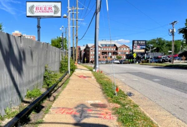
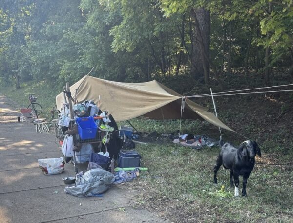
Arlington County aims to begin construction on a new traffic light at a crash-prone intersection near Barrett Elementary School this summer.
The county expects to complete the installation of the 4-way traffic signal — at N. Park Drive and N. George Mason Drive, in front of the Lubber Run Community Center — by the end of 2024. The intersection in the Arlington Forest neighborhood will also get curb extensions on all corners, increased street lighting and marked crosswalks, according to the county.
To get started, however, the county is requesting that the Arlington School Board approve an easement at the intersection’s southwest corner, where Barrett is. The School Board is set to review the request tonight (Thursday), teeing it up for a vote at a later meeting.
Although a 2017 traffic study — done concurrently with plans to replace the aging former community center — recommended a traffic signal, the county opted for a Rectangular Rapid Flashing Beacon and pedestrian refuge. Since the completion of the new community center, the troubled intersection has seen an uptick in crashes, primarily when drivers have to traverse four lanes of traffic on N. George Mason Drive to try to turn left or go straight on N. Park Drive.
Arlington was working to get a signal installed within the next three years. To address “recurring patterns of dangerous vehicle crashes at the intersection,” however, the county committed to complete work in 2024.
Meanwhile, DES installed an interim solution to calm traffic in December and removed and trimmed overgrown trees and shrubs in the median to improve sight distances.
The county temporarily closed the left turn and through movements from N. Park Drive using signage, flexible posts and wheel stops, per a brief explainer. Left turns will continue to be permitted from N. George Mason Drive to access northbound or southbound N. Park Drive.
As for the traffic signal, the county expects to finalize detailed designs by late this spring and begin construction this summer. The barriers will be removed when the traffic signals go in at the end of next year.
This spring, drivers may notice the county testing out a new road treatment to reduce speeding through left turns.
In the next month or two, the county will start installing small raised bumps called hardened centerlines along the yellow centerline at five local intersections. That’s according to Christine Baker, who coordinates Arlington’s Vision Zero efforts, which aim to eliminate road deaths and serious injuries by 2030.
Hardened centerlines are designed to make intersections safer for pedestrians by encouraging drivers to make wider, “safer and more predictable” left turns at slower speeds, without reducing traffic capacity, per an explainer for the pilot. Another goal is to increase the visibility of pedestrians in crosswalks.
Drivers will find the centerlines at five intersections that were chosen through crash hot spot reviews and other crash analyses showing these locations experience noticeable left-turn crash patterns, the county says.
The intersections — and the number of serious and fatal crashes they have seen between 2013-2023 — are:
- Clarendon Blvd at N. Rhodes Street, between Courthouse and Rosslyn (three four severe-injury crashes, including three involving pedestrians)
- Fairfax Drive at N. Randolph Street, in Ballston (six severe-injury crashes, equally split among pedestrian and angle crashes)
- Columbia Pike at S. Dinwiddie Street, near Arlington Mill (26 severe-injury crashes and one fatal crash, including 10 pedestrian crashes and nine angle crashes)
- Columbia Pike at S. Four Mile Run Drive, near Barcroft (a fatal pedestrian crash in 2019)
- S. Kenmore Street at 24th Street S., in Green Valley (no data on critical and fatal crashes in the last decade)
“We are excited to be piloting new in-street centerline hardening devices in Arlington later this spring,” said a February Vision Zero newsletter announcing the pilot. “Hardened centerlines are a proven safety tool used to reduce turning speeds and increase visibility of pedestrians for turning motorists at intersections.”
Arlington’s Dept. of Environmental Services will install the devices and collect data over the course of spring. This summer, the county will monitor how road users take to the new devices and collect feedback from the community before evaluating next steps in the fall.
Similar devices have been installed at numerous intersections in D.C.
A new report on crash “hot spots” in Arlington, published this month, says centerline hardening is also coming to Langston Blvd and Fort Myer Drive, in Rosslyn.
(Updated at 12:30 p.m.) Arlington County is home to one of the busiest Goodwill donation centers in the country and this location, on S. Glebe Road, is now being teed up for redevelopment.
Last week, Planning Commission members recommended the Arlington County Board approve plans from Goodwill and affordable housing partner AHC to redevelop its storefront with a 6-story building consisting of a new retail and donation center, 128 units of affordable housing and space for a child care center.
The Board is set to review the proposal — which includes requests to rezone the property and label it a “revitalization area,” a designation intended to boost AHC’s application for low-income housing tax credits — on Saturday.
Still, some criticism over pedestrian safety for elderly residents and children tempered that enthusiasm, as did questions to affordable housing partner AHC Inc. about its ability to manage an affordable community following livability issues residents and advocates revealed at the Serrano Apartments on Columbia Pike.
“There’s just so much to love about this project,” said Planning Commissioner Leo Sarli. “We cannot have enough housing… childcare or upcycling — which is what Goodwill does — which again, keeps things out of landfill and has a massive environmental impact.”
Despite all this, he had lingering pedestrian safety concerns around the site entrance, given all the foot and vehicular traffic that apartments, retail and childcare are expected to generate. This led him to propose that the Planning Commission recommend the County Board defer its approval until Goodwill addresses them. While other commissioners likewise stressed their pedestrian safety concerns, his motion failed 9-1, with one abstention.
They later supported a resolution from Vice-Chair (and Arlington County Board candidate) Tenley Peterson to recommend county staff continue to work with the applicant to design streets around the building that use “pedestrian-forward design practices.”
“We don’t want to let the perfect be the enemy of the good,” she said. “This project offers so much value to the community.”
Land use attorney Andrew Painter said the proposal actually improves pedestrian safety by separating donor, resident and retail traffic, reducing surface parking from 54 spaces to four accessible ones and closing one of two existing site entrances.
County staffer Kevin Lam, meanwhile, assured Planning Commissioner members that transportation staff thoroughly reviewed the proposal and do not believe the site poses a significant safety issue, though it is a “conflict point between pedestrians and vehicles.”
Like Peterson, the Transportation Commission approved the project, though several had pedestrian safety concerns. Chair Chris Slatt said commissioners hope these are addressed post-approval and commended Goodwill for transportation upgrades it has committed to, including one-way parking access, fewer surface parking spaces and a wider, raised sidewalk across the driveway.
Wider sidewalks, additional turning lanes and changes to bus stops are part of a newly released plan to make a busy stretch of Glebe Road safer.
The Virginia Department of Transportation on Monday announced possible changes to 2.4 miles of Glebe Road between Columbia Pike and I-66.
This stretch of Glebe Road being studied, which averages about 24,000 vehicles a day, has registered numerous crashes in recent memory, including a crash in the Ballston area that injured multiple people in April 2022.
Several of the proposed upgrades are intended to address pedestrian safety.
VDOT is considering widening all sidewalks on this stretch to 5 feet and upgrading curb ramps in keeping with the Americans with Disabilities Act. Sidewalks on the west side of Glebe Road between 14th Street N. and 13th Street N. would be widened to 8 feet to create a “multi-use path,” according to a press release.
The state would also create a “pedestrian refuge island” by removing the leftmost southbound lane of Glebe Road at N. Carlin Springs Road and widening the median.
Plans also indicate two left-turn lanes could be added to N. Carlin Springs Road, which drew criticism from Chris Slatt, chair of Arlington’s Transportation Commission.
VDOT proposing to add double-left turn lanes, in an urban area, as part of SAFETY project. Time to burn it all down and start fresh over there. pic.twitter.com/yK8M4kzK9E
— Chris Slatt (@alongthepike) February 6, 2024
Other proposed changes include:
- Changing the N. Carlin Springs Road lane configuration in order to add a second left turn lane.
- Adding a dedicated southbound Glebe Road left turn lane and dedicated northbound right turn lane at N. Quincy Street, a bike lane on the southbound Glebe Road approach at N. Quincy Street and N. Henderson Street, and special transit signal heads for the southbound bus lane.
- Combining bus stops between 4th Street N. and N. Quebec Street into two new bus stops connected by a new crosswalk with rectangular rapid flashing beacons.
- Adding a dedicated southbound Glebe Road left turn lane at 7th Street S.
VDOT — which expects to complete its study of this stretch of roadway in the fall — is now taking public comment on the plans.
People have until Monday, Feb. 19 to provide a second round of feedback on the department’s plans for this portion of the roadway, which contains 32 intersections.
Sometime next year, three residential streets in Arlington without sidewalks could get upgrades to allow for safer pedestrian and cyclist use.
To help address demonstrated safety and access issues on S. Lynn Street, N. Wakefield Street and 12th Street S., Arlington County’s Neighborhood Complete Streets Program is considering piloting “shared streets.”
On these streets, the county would slow down traffic and give cyclists and pedestrians more space through signs, barriers and other features, rather than building a sidewalk.
County staff picked these streets because they have incomplete sidewalks and characteristics “that make adding a sidewalk prohibitively difficult,” says Neighborhood Complete Streets Program Manager Michelle Stafford.
These characteristics include limited public right-of-way, difficult terrain and high parking demand. The streets also ranked above other streets nominated for the pilot program because of their crash histories as well as their proximity to schools, commercial corridors and transit.
“People currently drive, bike and walk in the street in these locations, but we can add features to the street to make that shared street conditions safer and more comfortable for all,” Stafford said in a recent presentation.
The identified streets in the Arlington Ridge, Douglas Park and Bluemont neighborhoods, and the challenges they pose for adding sidewalks, are as follows:
Shared streets can surmount these challenges, according to pilot project manager Brian Shelton.
“Shared streets can meet the desires of adjacent residents and function foremost as a public space for recreation, socializing and leisure,” Shelton said. “Many streets in Arlington already function as a shared street, however, we are missing some of the treatments which would enhance pedestrian comfort on these roadways.”
Shelton said staff have looked at recommended shared street tools from the National Association of City Transportation Officials, or NATCO, and opted to pursue a handful of strategies that make use of temporary materials and do not require significant construction.
These include midblock treatment options, such as chicanes — which narrow the road such that drivers are forced to slow down — and street entrance changes, including curb extensions.
Entrances to shared streets also typically have advisory signs and pavement markings to “eliminate the confusion of how the street is intended to be used,” Shelton said.
This fall, the county solicited feedback from residents on how the projects might change how they feel travelling these roads. This input will be used to refine designs, which are set to be finalized for funding hearings in early spring of next year.
Later this coming spring, the county expects to start implementing these shared streets. County staff will monitor these streets to ensure each corridor is functioning as intended, per the county website.
This weekend, the Arlington County Board is set to consider a proposal to funnel nearly $400,000 into the second phase of the Bluemont Junction Trail safety project.
Phase 2 includes moving and updating three trail connectors to be accessible to people with disabilities and improving cyclist and pedestrian intersections between the W&OD Trail and the Four Mile Run Trail on both sides of Wilson Blvd, per a county report.
The plan also calls for resurfacing a 480-foot segment of Four Mile Run Trail and repairing a nearby pedestrian bridge.
The project is part of a multi-year county effort to address poor visibility between trail users and drivers along the Bluemont Junction Trail, which crosses the Bluemont neighborhood and connects Ballston to the W&OD Trail at Bluemont Park. Plans were developed by the county with input from the public and the Bluemont Civic Association, the Bicycle Advisory Committee and the Pedestrian Advisory Committee
In the project’s first phase, which spanned the fall of 2021 to last summer, the county and the Virginia Dept. of Transportation made upgrades to roughly 4,500 linear feet and 13 connector trails, the report said. This included reconfiguring the trail’s intersections with N. Emerson Street and N. Kensington Street.
The second phase, however, demands more “in-depth engineering” than the milling and repaving carried out in the first phase, the report said.
Rep. Don Beyer has earmarked $325,000 in federal funds for the second phase of the project, which has an estimated total cost of $711,662.
The community will have an opportunity to provide input on the designs and proposed improvements if the funds are allocated, a county staff report notes.
The Arlington County Board is set to update the rules of the road to align with a new state law aimed at improving pedestrian safety.
This weekend, the Board is set to enact changes to local ordinances requiring drivers to stop for pedestrians in crosswalks. These changes were advertised this summer.
Currently, county code only requires drivers to yield to those crossing the street on foot, according to a county report. This conflicts with state code, which was amended this March to require drivers to “stop for” pedestrians.
In addition to being consistent with state law, the proposed changes support Arlington’s Vision Zero effort to eliminate traffic deaths and serious injuries by 2030, the report says.
“Pedestrians are one of our most vulnerable road users because their bodies are not surrounded with a metal frame and airbags,” the report says. “This law encourages drivers to look for, be aware of, and stop for pedestrians to help get to Arlington’s goal of Vision Zero transportation deaths or serious injuries by 2030.”
The report notes that, from 2018-2022, a third of all severe or fatal crashes in Arlington County involved a pedestrian.
A county data dashboard shows there were 82 pedestrian crashes in those years, spread fairly evenly over those years and located all throughout the county. The number of fatal pedestrian crashes reached a high of four in 2019.
Any driver who does not stop is guilty of a traffic infraction and can face a $100-$500 fine, according to the new law.
The county intends to notify residents of the change via a press release, emails and social media posts, per the report.
There will also be new signage, the Dept. of Environmental Services previously told ARLnow.
Plans to build the future pedestrian bridge from Crystal City to National Airport are firming up.
A new report outlines the impact the bridge could have on the environment. It also details how the project will relate to separate plans to redo roadways and add more parking, new car rental facility and office space.
The environmental assessment says the impact on scenic views for drivers on the GW Parkway, as well as vegetation removal, is expected to be relatively minimal. Up to 146 trees could be removed for construction and the area would later be replanted.
Now through Oct. 3, community members can comment online on the report, Arlington Dept. of Environmental Services spokeswoman Erin Potter tells ARLnow. They can also attend a public hearing on Sept. 19 at the Aurora Hills Recreation Center (735 18th Street S.).
Even with the pedestrian bridge, the Metropolitan Washington Airports Authority (MWAA), which governs DCA and Dulles International Airport, says it does not project reduced vehicle traffic to and from the airport. As such, it is designing significant upgrades for drivers.
“The overall number of passengers and employees shifting to the multi-modal access would not have a notable effect on the forecast traffic demand on the Airport roadway network or the demand for on-Airport passenger and employee parking,” a report for the MWAA project says.
While MWAA is not leading the bridge project, it did have input on where the pedestrian bridge could go, the report says. It notes that where the bridge goes and what angle it is at will not alter the project’s environmental impacts.
MWAA asked Arlington County and the Virginia Dept. of Transportation to move the bridge to reduce impacts on existing parking and accommodate a proposed elevated ramp west of the West Entrance Road, the report says.
“Arlington County and the CC2DCA project team have been working closely with MWAA staff to coordinate delivery of the safety and access improvements provided by both projects,” says Potter.
Construction on the CC2DCA bridge is expected to begin construction in late 2027 and last for two years, Potter said. Since MWAA is still finalizing a timeline for its road improvements, VDOT and Arlington are blocking off an area where the bridge could go and deciding on a final alignment later.
The new report describes how the preferred option marries two other alternatives: one that crossed the GW Parkway and Mount Vernon Trail at a significant angle and another that provided a straight shot. The new renderings also show that, of the two Mount Vernon Trail link options, a more curved path was chosen.
As planning efforts continue for projects at DCA, the surrounding area is set to see changes, too.
An airport access road is set to be removed to make way for a redevelopment project proposed by JBG Smith. Near the Crystal City-side of the bridge, a second entrance to the Crystal City Metro station and a new Virginia Railway Express station and Amtrak platform are being built.
Meanwhile, the Mount Vernon Trail is set to be widened to 11 feet, a planned Crystal City bicycle network could be completed next year and the bus rapid transit network will be extended to Pentagon City.
The pedestrian experience is set to improve in nearly a dozen spots across the county.
The Arlington County Board this weekend is expected to approve two projects for accessibility improvements, along the Rosslyn-Ballston corridor and in three residential neighborhoods.
The Metro corridor contract, for up to nearly $1.4 million, is the second phase of an existing effort to bring the streetscape up to Americans with Disabilities Act standards. The planned improvements include “new sidewalks, curb and gutter, curb extensions, handicap accessible ramps, storm sewer pipes and inlets, paving, pavement markings and signage.”
From a county staff report:
The Rosslyn – Ballston Corridor ADA Improvements Project – Phase 2 sites are located along the Rosslyn – Ballston Corridor. This project reconstructs multiple intersections within the Rosslyn-Ballston Corridor where existing sidewalks, curb ramps or street intersections do not comply with standards of the ADA.
The project undertakes redesign and construction in batches with the highest priority problem areas reconstructed to achieve ADA compliance. The project incorporates a “second set” of improvements previously designated under P14D. It spans multiple neighborhoods, including Buckingham, Ballston-Virginia Square, Clarendon, Courthouse, Rosslyn.
The other project is part of another ongoing effort, the county’s Neighborhood Complete Streets (NCS) program.
It would bring improvements to three residential neighborhoods, including curb extensions to resolve several blocks of sidewalk obstructed by decorative streetlights.
From a staff report, the project would:
Construct one block of missing sidewalk on 14th Street North from North McKinley Road to North Ohio Street, in the Highland Park Overlee Knolls neighborhood;
Construct two improved intersections, with updated curb ramps and reduction of pedestrian crossing distances, on 8th Road South in the Arlington Mill neighborhood;
Construct eight curb extensions to relocate existing Carlyle Streetlights currently obstructing the sidewalk and provide an accessible path along three blocks of existing sidewalk on South Irving Street, in the Arlington Heights neighborhood
“The Neighborhood Complete Streets program was approved by the Arlington County Board at its January 2016 meeting,” says the report. “The program was intended as a replacement to and evolution of the prior Neighborhood Traffic Calming (NTC) program, which built approximately 175 projects designed to slow vehicle speed. The NCS program was designed to holistically address inadequacies in the complete streets paradigm, outlined in the Master Transportation Plan.”
“A complete street is one that provides facilities for pedestrians, cyclists, transit riders and motorists to each move comfortably and safely through the community,” the report notes. “Project requests were to be solicited from community members, prioritized based on objective data, and selected with consultation and oversight from the [Neighborhood Complete Streets Commission], following a public engagement period.”
Photo via Google Maps
In a bid to increase pedestrian safety, Arlington County may require drivers stay stopped for longer at crosswalks.
The Arlington County Board is set to consider on Saturday changing its code so that drivers will have to stop when a pedestrian enters an adjacent travel lane and heads their way. Currently, drivers need only yield right of way when a pedestrian enters their lane.
The change follows on a revision to state law that went into effect on July 1. The local change is another way Arlington aims to eliminate serious and fatal crashes — particularly for pedestrians, who made up one-third of serious or fatal crashes between 2018 and 2022.
“Pedestrians are one of our most vulnerable road users because their bodies are not surrounded with a metal frame and airbags,” a county report said. “It is critical for drivers to look for, be aware of, and stop for pedestrians to help get to Arlington’s goal of Vision Zero transportation deaths or serious injuries by 2030.”
In Arlington, the change would apply to local and state roads, says Dept. of Environmental Services spokeswoman Katie O’Brien. This includes major arterials that see the county’s highest concentration of serious crashes, such as Arlington, Langston and Washington boulevards and Glebe Road.
The county says the intent of its ordinance change is to reflect wording changes in state law.
This March, the state put a finer point on what drivers are required to do when they see a pedestrian looking to cross.
Before, drivers were required to “yield right-of-way to pedestrians by stopping” when pedestrians are crossing in front of the drivers.
Now, state code says drivers “shall stop” when a pedestrian is within the driver’s lane or within an adjacent lane and approaching the driver’s lane. Drivers are required to stay stopped until the pedestrian has passed their lane.
Any driver who does not stop is guilty of a traffic infraction and can face a $100-$500 fine, according to the new law.
Staff intends to inform the public of the new law via a press release, emails, and social media posts on NextDoor, Twitter and Facebook, per the report.
O’Brien says new signage will be also added.
“We are working on plans to make signage and marking changes to be in compliance with the new code,” she said.
The law also lets localities require pedestrians and cyclists to stop before crossing a highway at crosswalks without signals or face a fine of up to $100.
Redevelopment plans for a Holiday Inn and office building in Ballston are headed to the Arlington County Board for approval.
The developers, Hoffman & Associates and Snell Properties, intend to replace the hotel (4600 Fairfax Drive) and Arlington Center Building (4610 Fairfax Drive) with a seven-story, 432-unit apartment building and two five-story, 15-unit buildings.
The development duo also propose building a new private road and alley for parking and loading activity, as well as new sidewalks and streetscapes along them.
The site is located west of N. Glebe Road, along N. Fairfax Drive, just before it becomes an on- and off-ramp to I-66. It is five blocks from the Ballston Metro station and two blocks from a proposed western entrance, currently in an early design phase.
“This site has a lot of surface parking, structured parking, an office building, the Holiday Inn, and a disconnected relationship to our neighbors to the south,” Cathy Puskar, a land use attorney for the developers, told the Planning Commission last week. “It’s been here quite a long time… so we are very eager to move forward with that.”
Hoffman and Snell have cleared nearly every step in the public review process. On Saturday, the Arlington County Board is set to review their request for easements in order to build on the site.
Much has changed since the initial submission more than a year ago.
“This project went through a substantial evolution as we went through the [Site Plan Review Committee] process,” Arlington County planner Adam Watson said during the Planning Commission meeting.
In response to public feedback, the layout changed and a bicycle and pedestrian path was widened to 12 feet and moved.
The 5-story buildings are now to the west of the 7-story building, rather than to its south. Watson says this creates a better height transition from the tall George Washington University building at 950 N. Glebe Road to the single-family homes west of the 4600 Fairfax Drive site.
Now, the proposed path separates the 7-story and 5-story buildings. Watson says this furthers county plans to add a “West Ballston Connection” linking with the Bluemont Junction, Custis and Ballston Pond trails at Fairfax Drive.
Watson said the project now delivers “a much improved streetscape, especially along Fairfax Drive” and less impervious surface area. It preserves more trees to increase the buffer between the development and the single-family homes nearby, he said.
“We really loved that first version… but we are very proud of where we are today,” Puskar said. “Despite some painful cuts and changes, we listened, and this is why we have such a good plan in front of you today.”
While the developers directed the bulk of residential traffix to Fairfax Drive — as opposed to the smaller private road south of the site, to allay concerns about traffic flow — some residents still have misgivings, Planning Commissioner Jim Lantelme said.
Climate Change, Energy and Environment Commission representative Mark Greenwood praised the project’s use of electricity rather than gas, but suggested the developers replace the gas stoves with induction ones, while adding more parking for electric vehicles.