

Update at 2:15 p.m. — On top of everything else, a Severe Thunderstorm Watch was just issued for the region, through 9 p.m. Severe storms packing damaging winds are possible later today (Saturday), with some Severe Thunderstorm Warnings already in effect west of the immediate D.C. area.
A severe thunderstorm watch has been issued for parts of District of Columbia, Maryland, North Carolina, Virginia and West Virginia until 9 PM EDT pic.twitter.com/vJPO2kTTQE
— NWS Baltimore-Washington (@NWS_BaltWash) July 18, 2026
Earlier: A Flood Watch has been issued for Arlington, in effect Saturday afternoon and evening.
Forecasters say very heavy rainfall is possible later today, potentially causing flash flooding.
More from the National Weather Service:
Flood Watch issued July 18 at 11:43AM EDT by NWS Baltimore MD/Washington DC
FLOOD WATCH IN EFFECT FROM 2 P.M. TO 8 P.M. EDT SATURDAY.
A slow-moving front will interact with a very humid airmass in place to result in multiple rounds of showers and thunderstorms this afternoon and evening.
* WHAT…Flash flooding caused by excessive rainfall continues to be possible.
* WHERE…Washington DC, and portions of Maryland, including the following areas, Anne Arundel, Carroll, Cecil, Central and Southeast Howard, Central and Southeast Montgomery, Frederick, Northern Baltimore, Northwest Harford, Northwest Howard, Northwest Montgomery, Prince Georges, Southeast Harford and Southern Baltimore, and northern Virginia, including the following areas, Arlington/Falls Church/Alexandria, Eastern Loudoun, Fairfax and Western Loudoun.
* WHEN…From 2 PM this afternoon through 8 PM EDT this evening.
* IMPACTS…Excessive runoff may result in flooding of rivers, creeks, streams, and other low-lying and flood-prone locations. Flooding may occur in poor drainage and urban areas.
* ADDITIONAL DETAILS… – High humidity coupled with a slow-moving front is expected to result in multiple rounds of showers and thunderstorms this afternoon and evening. Localized rainfall rates of up to 2 inches per hour, with isolated totals of 2 to 4 inches are possible. – Please visit www.weather.gov/safety/flood for flood safety and preparedness information.
You should monitor later forecasts and be prepared to take action should Flash Flood Warnings be issued.
The Flood Watch is on top of a Heat Advisory, issued earlier today and currently in effect.
Heat index values in the triple digits are expected Saturday afternoon, according to NWS.
750 AM EDT Sat Jul 18 2026
…HEAT ADVISORY REMAINS IN EFFECT THROUGH 7 PM EDT THIS EVENING…
* WHAT…Heat index values around 105 expected.
* WHERE…Washington DC, and portions of central, northern, and southern Maryland, and central and northern Virginia.
* WHEN…From 11 AM this morning to 7 PM EDT this evening.
* IMPACTS…Hot temperatures and high humidity may cause heat illnesses.
PRECAUTIONARY/PREPAREDNESS ACTIONS…
Drink plenty of fluids, stay in an air-conditioned room, stay out of the sun, and check up on relatives and neighbors.
Take extra precautions when outside. Wear lightweight and loose fitting clothing. Try to limit strenuous activities to early morning or evening. Take action when you see symptoms of heat exhaustion and heat stroke.
To reduce risk during outdoor work, the Occupational Safety and Health Administration recommends scheduling frequent rest breaks in shaded or air conditioned environments. Anyone overcome by heat should be moved to a cool and shaded location. Heat stroke is an emergency! In cases of heat stroke, call 9 1 1.
Due to the heat, Arlington’s Dept. of Parks and Recreation has cancelled or moved indoors all outdoor activities from noon to 4 p.m. From DPR:
On Sat., July 18, all Parks & Recreation and partner outdoor programming (including league practices and games) at County outdoor facilities between 12-4 p.m. will be moved to indoor locations or canceled due to a Heat Advisory. Impacts to programming at Arlington County community centers, parks, or facilities will be communicated directly to program participants via email. Should the weather change, programmatic updates will also be communicated directly to participants.
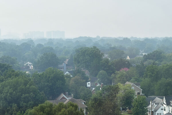
That’s not all — wildfire smoke is still present, making the outside air moderately unhealthy.
It’s not as bad as Friday, but as of noon there is a visible haze and AirNow.gov say the local air quality is at a Code Red level that can be hazardous for sensitive groups.
