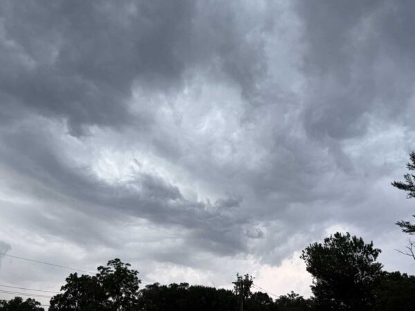
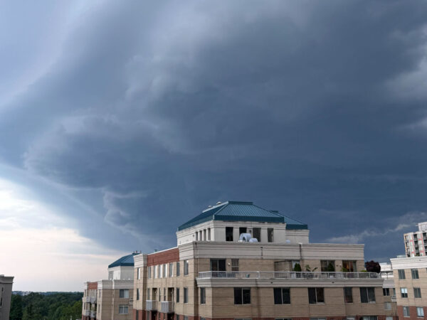
Join Club
Flood Watch graphic (Photo via National Weather Service/Twitter)

Arlington County, D.C. and its immediate neighbors are under a Flood Watch starting early Monday morning.

Heavy rain is expected overnight and during the morning commute. The soaking rainfall may cause isolated flooding.

More from the National Weather Service:

…FLOOD WATCH IN EFFECT FROM 4 AM EDT TUESDAY THROUGH TUESDAY AFTERNOON…

* WHAT…Flash flooding caused by excessive rainfall is possible.

* WHERE…Portions of DC, Maryland and northern Virginia, including the following areas: in DC, District of Columbia. In Maryland, Anne Arundel, Carroll, Cecil, Central and Southeast Howard, Central and Southeast Montgomery, Frederick MD, Northern Baltimore, Northwest Harford, Northwest Howard, Northwest Montgomery, Prince Georges, Southeast Harford and Southern Baltimore. In northern Virginia, Arlington/Falls Church/Alexandria, Eastern Loudoun, Fairfax and Western Loudoun.

* WHEN…From 4 AM EDT Tuesday through Tuesday afternoon.

* IMPACTS…Excessive runoff may result in flooding of rivers, creeks, streams, and other low-lying and flood-prone locations.

* ADDITIONAL DETAILS…
– An area of low pressure is expected to develop along a slow moving boundary draped across the region Tuesday morning through early Tuesday afternoon. Heavy showers and a few thunderstorms are expected to drop 2 to 3 inches across much of the watch area, with isolated higher amounts up to 5 inches possible in the heaviest cells.
– http://www.weather.gov/safety/flood

PRECAUTIONARY/PREPAREDNESS ACTIONS…

You should monitor later forecasts and be prepared to take action should Flash Flood Warnings be issued.

More via social media:

Photo via National Weather Service/Twitter

0 Comments
Heavy rain along Four Mile Run Drive near Shirlington (file photo by Jay Westcott)

Arlington — along with D.C., Alexandria, Fairfax County and most of the rest of Northern Virginia — is under a Flood Watch today.

The watch takes effect at 2 p.m. and will remain in effect into the evening hours as slow-moving storms roll into the area.

The combination of slow storm movement and the potential for training — a series of downpours focused on a specific west-to-east area — raises the possibility of flooding, forecasters say.

More from the National Weather Service:

…FLOOD WATCH REMAINS IN EFFECT FROM 2 PM EDT THIS AFTERNOON THROUGH THIS EVENING…

* WHAT…FLASH FLOODING CAUSED BY EXCESSIVE RAINFALL CONTINUES TO BE POSSIBLE. […]

* IMPACTS…EXCESSIVE RUNOFF MAY RESULT IN FLOODING OF RIVERS, CREEKS, STREAMS, AND OTHER LOW-LYING AND FLOOD-PRONE LOCATIONS.

* ADDITIONAL DETAILS…
– SHOWERS AND NUMEROUS THUNDERSTORMS ARE EXPECTED THIS AFTERNOON INTO THIS EVENING. RAINFALL AMOUNTS WILL AVERAGE AROUND 1 TO 1.5 INCHES ACROSS THE AREA, BUT LOCALLY HIGHER AMOUNTS OF 2 TO 4 INCHES ARE LIKELY AND MUCH OF THAT MAY FALL IN A ONE TO TWO HOUR TIMEFRAME. HEAVY RAIN IN SHORT PERIODS OF TIME MAY CAUSE CREEKS AND STREAMS TO RAPIDLY RISE OUT OF THEIR BANKS ALONG WITH POTENTIAL FLASH FLOODING IN URBAN AREAS.
– HTTP://WWW.WEATHER.GOV/SAFETY/FLOOD

PRECAUTIONARY/PREPAREDNESS ACTIONS…

YOU SHOULD MONITOR LATER FORECASTS AND BE PREPARED TO TAKE ACTION SHOULD FLASH FLOOD WARNINGS BE ISSUED.

0 Comments
Flood Watch boundaries (via NWS)

Slow-moving storms this afternoon and evening may pack downpours that could cause flooding, forecasters say.

The National Weather Service just issued a Flood Watch for Arlington, the District and most of the region as a result.

From NWS:

1020 AM EDT Fri Aug 5 2022

…FLOOD WATCH IN EFFECT FROM 3 PM EDT THIS AFTERNOON THROUGH THIS EVENING…

* WHAT…Flash flooding caused by excessive rainfall is possible. […]

* WHEN…From 3 PM EDT this afternoon through this evening.

* IMPACTS…Excessive runoff may result in flooding of rivers, creeks, streams, and other low-lying and flood-prone locations.

* ADDITIONAL DETAILS…
– Showers and thunderstorms will develop this afternoon and may last into the evening. Any thunderstorms will be capable of producing very heavy rainfall, with localized totals of two to four inches possible. Much of the rain may fall within a one to three hour period, making rapid rises in creeks and streams possible, as well as flash flooding in urban areas.
– http://www.weather.gov/safety/flood

PRECAUTIONARY/PREPAREDNESS ACTIONS…

You should monitor later forecasts and be prepared to take action should Flash Flood Warnings be issued.

0 Comments
Boundaries of Severe Thunderstorm Watch on 7/25/22 (via National Weather Service)

Update at 3:50 p.m. — A Severe Thunderstorm Warning has been issued for the far northern tip of Arlington.

Earlier: Arlington, D.C. and most of the region is now under a Severe Thunderstorm Watch.

The watch, which was issued around 1:45 p.m., is in effect until 10 p.m.

Forecasters say storms packing damaging winds and heavy downpours are possible this afternoon and evening. More from NWS:

Thunderstorms will further develop and intensify initially near/just of the mountains, and subsequently spread eastward toward the I-95 corridor through late afternoon and early evening. Damaging winds are the primary hazard.

Local authorities, meanwhile, are encouraging residents to prepare for the possibility of severe weather.

Some of the tips include charging essential devices and securing loose items from lawns and balconies.

https://twitter.com/ArlingtonVaFD/status/1551631655596544000

0 Comments
Flood Watch boundaries (via NWS)

Update at 1:50 p.m. — A Severe Thunderstorm Watch was just issued for parts of the D.C. area, including Arlington, and much of the D.C.-Baltimore-Philly-NYC corridor. That’s in addition to the Flood Watch, below.

From the National Weather Service:

Scattered severe thunderstorms are possible this afternoon and evening, mainly north of the D.C. metro area. Damaging wind gusts are the primary threat with an isolated tornado also possible.

Earlier: It’s the middle of July and the humidity level outside is roughly that of an unventilated bathroom after a half-hour hot shower.

Unsurprisingly, that combination is a recipe for possible downpours — and flooding — tonight.

The National Weather Service just issued a Flood Watch, which will go into effect at 4 p.m. Forecasters say “multiple rounds of storms” could cause flooding later today.

More from NWS:

FLOOD WATCH
NATIONAL WEATHER SERVICE BALTIMORE MD/WASHINGTON DC
931 AM EDT MON JUL 18 2022

…FLOOD WATCH IN EFFECT FROM 4 PM EDT THIS AFTERNOON THROUGH THIS EVENING…

* WHAT…FLASH FLOODING CAUSED BY EXCESSIVE RAINFALL IS POSSIBLE.

* WHERE…PORTIONS OF DC, MARYLAND AND NORTHERN VIRGINIA […]

* WHEN…FROM 4 PM EDT THIS AFTERNOON THROUGH THIS EVENING.

* IMPACTS…EXCESSIVE RUNOFF MAY RESULT IN FLOODING OF RIVERS, CREEKS, STREAMS, AND OTHER LOW-LYING AND FLOOD-PRONE LOCATIONS.

* ADDITIONAL DETAILS…
– AFTERNOON TO EVENING SHOWERS AND THUNDERSTORMS MAY PRODUCE VERY HEAVY RAINFALL CAPABLE OF FLASH FLOODING. THIS COULD INCLUDE MULTIPLE ROUNDS OF STORMS WHICH WOULD ENHANCE THE FLOOD RISK. RAINFALL RATES MAY REACH 1 TO 2 INCHES PER HOUR, LOCALLY HIGHER IN SPOTS. THE D.C. AND BALTIMORE METROS WILL BE THE MOST SUSCEPTIBLE GIVEN RECENT HEAVY RAINFALL THE PAST COUPLE OF WEEKS.
– HTTP://WWW.WEATHER.GOV/SAFETY/FLOOD

PRECAUTIONARY/PREPAREDNESS ACTIONS…

YOU SHOULD MONITOR LATER FORECASTS AND BE PREPARED TO TAKE ACTION SHOULD FLASH FLOOD WARNINGS BE ISSUED.

0 Comments
Rainy drive in Clarendon (file photo)

Updated at 2:15 p.m. — A Severe Thunderstorm Watch was also just issued for the area.

Earlier: Arlington and much of the D.C. and Baltimore area is under a Flood Watch today, starting at 4 p.m.

Storms are expected later today, forecasters say. Heavy rain and strong winds are likely.

“Scattered severe thunderstorms are possible this afternoon and evening,” the National Weather Service says. “Damaging wind gusts and large hail are the primary threats. An isolated tornado is also possible.”

More on the Flood Watch from NWS, below.

…FLOOD WATCH IN EFFECT FROM 4 PM EDT THIS AFTERNOON THROUGH THIS EVENING…

* WHAT…Flash flooding caused by excessive rainfall is possible.

* WHERE…Portions of DC, Maryland and northern Virginia, including the following areas: in DC, District of Columbia. In Maryland, Anne Arundel, Central and Southeast Howard, Central and Southeast Montgomery, Northern Baltimore, Northwest Howard, Northwest Montgomery, Prince George’s and Southern Baltimore. In northern Virginia, Arlington/Falls Church/Alexandria, Fairfax and Prince William/Manassas/Manassas Park.

* WHEN…From 4 PM EDT this afternoon through this evening.

* IMPACTS…Excessive runoff may result in flooding of rivers, creeks, streams, and other low-lying and flood-prone locations. Creeks and streams may rise out of their banks.

* ADDITIONAL DETAILS…
– Strong to severe thunderstorms will move across the region late this afternoon through the evening hours. Heavy rain will accompany a number of these storms which may drop 1 to 2 inches of rainfall in an hour. Additionally, some regions could see repeat thunderstorm activity leading to an enhanced threat for flooding.
– http://www.weather.gov/safety/flood

PRECAUTIONARY/PREPAREDNESS ACTIONS…

You should monitor later forecasts and be prepared to take action should Flash Flood Warnings be issued.

0 Comments
Flood Watch map 7/8/22 (via National Weather Service)

Arlington and much of the D.C. area will be under a Flood Watch starting tonight.

Heavy rain and storms are expected tonight. The rain is expected to persist through Saturday afternoon, raising the possibility of flooding, including flash flooding caused by “excessive rainfall.”

The Flood Watch takes effect at 11 p.m.

From the National Weather Service:

URGENT – IMMEDIATE BROADCAST REQUESTED
FLOOD WATCH
NATIONAL WEATHER SERVICE BALTIMORE MD/WASHINGTON DC
1253 PM EDT FRI JUL 8 2022

…FLOOD WATCH IN EFFECT FROM 11 PM EDT THIS EVENING THROUGH SATURDAY AFTERNOON…

* WHAT…FLASH FLOODING CAUSED BY EXCESSIVE RAINFALL IS POSSIBLE.

* WHERE…WASHINGTON DC, MARYLAND AND NORTHERN VIRGINIA, INCLUDING THE FOLLOWING AREAS: IN DC, DISTRICT OF COLUMBIA. IN MARYLAND, ANNE ARUNDEL, CARROLL, CENTRAL AND SOUTHEAST HOWARD, CENTRAL AND SOUTHEAST MONTGOMERY, FREDERICK MD, NORTHERN BALTIMORE, NORTHWEST HARFORD, NORTHWEST HOWARD, NORTHWEST MONTGOMERY, PRINCE GEORGES, SOUTHEAST HARFORD AND SOUTHERN BALTIMORE. IN NORTHERN VIRGINIA, ARLINGTON/FALLS CHURCH/ALEXANDRIA, EASTERN LOUDOUN, FAIRFAX, PRINCE WILLIAM/MANASSAS/MANASSAS PARK AND WESTERN LOUDOUN.

* WHEN…FROM 11 PM EDT THIS EVENING THROUGH SATURDAY AFTERNOON.

* IMPACTS…EXCESSIVE RUNOFF MAY RESULT IN FLOODING OF RIVERS, CREEKS, STREAMS, AND OTHER LOW-LYING AND FLOOD-PRONE LOCATIONS.

* ADDITIONAL DETAILS…
– SHOWERS ARE EXPECTED WITH SCATTERED THUNDERSTORMS LATE THIS EVENING INTO MIDDAY SATURDAY. AVERAGE RAINFALL AMOUNTS AROUND 1 TO 3 INCHES ARE EXPECTED, BUT LOCALIZED AMOUNTS AROUND 4 TO 7 INCHES IN HEAVIER SHOWERS AND THUNDERSTORMS. RAINFALL AMOUNTS AROUND 1 TO 3 INCHES WITHIN AN HOUR OR TWO ARE POSSIBLE IN AREAS WHERE THE HEAVIEST RAINFALL OCCURS. THE BEST CHANCE FOR THE HEAVIEST RAINFALL WILL BE OVERNIGHT INTO SATURDAY MORNING.

0 Comments

Morning Notes

Dog park in Rosslyn (staff photo by Jay Westcott)

Arlington Rents Continue to Rise — “Apartment rents in Arlington keep on moving upward, maintaining their position as most expensive in the D.C. area and are now well above pre-pandemic rates, according to new data. With a median rental of $2,063 for a one-bedroom unit and $2,469 for two bedrooms, Arlington’s rental rate grew a whopping 2.8 percent from May to June, the sixth highest increase among the nation’s 100 largest urban areas.” [Sun Gazette]

Local Group Donating Thousands of Socks — “The Nursing Professional Development Council at VHC Health decided to have a ‘Sock Hop’ – not a dance party but a sock collection benefiting ‘Doorways,’ an Arlington non-profit helping people out of homelessness, domestic violence and sexual assault. The goal was set at 1,940 pairs – 1940 was the year the Sock Hop started but the generous nurses and staff at VHC Health tripled that number. It’s the biggest sock donation the group has ever received.” [WJLA]

Dems Resuming Breakfasts — “In another sign that life is getting back to normal(ish) – or at least adopting a ‘live with COVID’ practicality – the Arlington County Democratic Committee is resurrecting its monthly in-person breakfasts. The return engagement – the first since early 2020 – will be held on Saturday, July 9 at 8:30 a.m. at Busboys & Poets in Shirlington. Del. Patrick Hope (D-Arlington) and others will discuss gun issues.” [Sun Gazette]

Cleanup Event Saturday Morning — “WalkArlington & BikeArlington partner to clean up a part of the W&OD Trail on Saturday, July 9. We will make our way down the W&OD, starting near the Barcroft Community Center, setting up our tent on the W&OD Trail at the intersection of a small road named ‘Barcroft Center’ and Four Mile Run Drive. We will pick up trash that accumulates alongside the trail. We will provide trash bags, gloves, trash pickers, drinks and some snacks. We will also have Bike and Walk giveaways.” [WalkArlington]

Metro Seeking Feedback on EFC Project — “Metro is seeking public input on the proposed bus loop expansion and pedestrian improvements at East Falls Church Station.  The station currently has four bus bays that are operating at maximum capacity. In coordination with Metro, Arlington County seeks to expand the footprint of the existing bus loop, upgrade the existing bus shelters, and add three bus bays with shelters at the station.” [WMATA]

Flood Watch This Afternoon — “Multiple rounds of scattered to numerous showers and thunderstorms are likely this afternoon and tonight. The most likely time period for thunderstorms producing heavy rain and potential flash flooding is this evening, but thunderstorms could develop as early as this afternoon, and may linger well into the night. Several inches of rain is possible in a short period of time, which would cause rapid rises of water.” [National Weather Service]

It’s Wednesday — Heavy rain starting in the afternoon. High of 86 and low of 78. Sunrise at 5:51 am and sunset at 8:38 pm. [Weather.gov]

0 Comments
Storm clouds roll in behind a construction crane near Clarendon (Staff Photo by Jay Westcott)

Arlington and much of the D.C. area is now under a Severe Thunderstorm Watch.

The watch is in effect until 7 p.m.

“Strong to severe thunderstorms are possible late this afternoon and early evening,” the National Weather Service says. “Thunderstorms may produce gusty winds and hail.”

0 Comments
Around Rosslyn before the rain (staff photo by Jay Westcott)

(Updated at 1:40 p.m.) A wet and wild afternoon and evening could be on tap as heavy rain and storms packing strong winds move into the area.

Both a Flood Watch and a Severe Thunderstorm Watch have now been issued for Arlington, D.C. and other parts of the region.

The National Weather Service issued the storm watch around 1:35 p.m. It will remain in effect until 9 p.m.

The Flood Watch for  was issued just after 10 a.m. and is in effect from 3 p.m. to midnight.

From NWS:

1003 AM EDT Wed Jun 22 2022

…FLOOD WATCH IN EFFECT FROM 3 PM EDT THIS AFTERNOON THROUGH THIS EVENING…

* WHAT…Flooding caused by excessive rainfall is possible.

* WHERE…Portions of DC, Maryland and Virginia, including the following areas: in DC, District of Columbia. In Maryland,
Carroll, Central and Southeast Howard, Central and Southeast Montgomery, Northern Baltimore, Northwest Howard, Prince Georges and Southern Baltimore. In Virginia, Arlington/Falls Church/Alexandria, Fairfax, Prince William/Manassas/Manassas Park, Spotsylvania and Stafford.

* WHEN…From 3 PM EDT this afternoon through this evening.

* IMPACTS…Excessive runoff may result in flooding of rivers, creeks, streams, and other low-lying and flood-prone locations.

* ADDITIONAL DETAILS…
– Widespread showers and thunderstorms are expected later this afternoon into the evening. Given a very warm and moist air mass, these will produce some very heavy rainfall at times. Rainfall amounts of 1 to 3 inches are possible within the span of a couple of hours, with locally higher amounts possible.
– http://www.weather.gov/safety/flood

PRECAUTIONARY/PREPAREDNESS ACTIONS…

You should monitor later forecasts and be alert for possible Flood Warnings. Those living in areas prone to flooding should be prepared to take action should flooding develop.

0 Comments
Storm clouds forming, as seen in Rosslyn (staff photo by Jay Westcott)

Arlington County is now under a Severe Thunderstorm Watch.

Forecasters say strong storms are possible tonight (Thursday), with damaging winds and maybe even an isolated tornado.

The watch was issued at 3:30 p.m. and is in effect until midnight.

0 Comments
×

Subscribe to our mailing list