

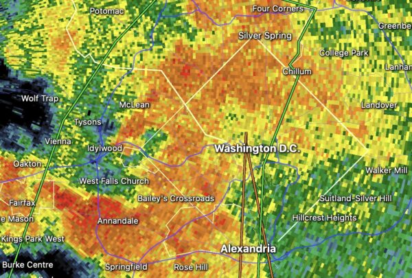
A Flash Flood Warning has been issued for Arlington amid sustained heavy rainfall.
The warning is in effect until 7:45 p.m. Nearly an inch of rain has fallen in at least one northern Arlington neighborhood with the latest wave of storms, which also prompted a Flood Watch following heavy rain earlier today.
More from the National Weather Service:
FLASH FLOOD WARNING IN EFFECT FROM 4:34 P.M. TO 7:45 P.M. EDT SUNDAY.
The National Weather Service in Sterling Virginia has issued a
* Flash Flood Warning for… Northwestern District of Columbia… Southeastern Montgomery County in central Maryland… Arlington County in northern Virginia… Eastern Fairfax County in northern Virginia… Eastern Prince William County in northern Virginia… The City of Alexandria in northern Virginia… The Southeastern City of Fairfax in northern Virginia… The City of Falls Church in northern Virginia…
* Until 745 PM EDT.
* At 434 PM EDT, Doppler radar indicated thunderstorms producing heavy rain across the warned area. Between 1.5 and 3 inches of rain have fallen. Additional rainfall amounts of 1 to 2.5 inches are possible in the warned area. Flash flooding is ongoing or expected to begin shortly.
HAZARD…Flash flooding caused by thunderstorms.
SOURCE…Radar.
IMPACT…Flash flooding of small creeks and streams, urban areas, highways, streets and underpasses as well as other poor drainage and low-lying areas.
* Some locations that will experience flash flooding include… Arlington… Alexandria… Dale City… Bethesda… Annandale… Springfield… Fairfax… Langley Park… Fort Hunt… Vienna… Groveton… Falls Church… Huntington… Mantua… Fort Belvoir… Pimmit Hills… Woodbridge… Mclean… Rosslyn… Crystal City…
Turn around, don’t drown when encountering flooded roads. Most flood deaths occur in vehicles.
Keep children away from storm drains, culverts, creeks and streams. Water levels can rise rapidly and sweep children away.
Flash Flood Warning including Washington DC, Arlington VA and Alexandria VA until 7:45 PM EDT pic.twitter.com/SNP9KopNdN
— NWS Baltimore-Washington (@NWS_BaltWash) August 2, 2026
Earlier: A Flood Watch has been issued for Arlington and much of the D.C. area.
The watch is in effect until midnight. Forecasters say additional heavy rainfall is possible Sunday afternoon and evening, which could lead to flooding given that the area has already received 1-2 inches of rain.
More from the National Weather Service:
Flood Watch issued August 2 at 3:50PM EDT by NWS Baltimore MD/Washington DC
FLOOD WATCH IN EFFECT FROM 3:50 P.M. SUNDAY TO MIDNIGHT EDT MONDAY.
* WHAT…Flash flooding caused by excessive rainfall is possible.
* WHERE…The District of Columbia, and portions of Maryland, including the following areas, Anne Arundel, Central and Southeast Howard, Central and Southeast Montgomery, Prince Georges and Southern Baltimore, and northern Virginia, including the following areas, Arlington/Falls Church/Alexandria, Central and Southeast Prince William/Manassas/Manassas Park and Fairfax.
* WHEN…Until midnight EDT tonight.
* IMPACTS…Excessive runoff may result in flooding of creeks, streams, and other low-lying and flood-prone locations. Flooding may occur in poor drainage and urban areas.
* ADDITIONAL DETAILS… – Portions of the Baltimore Washington Metropolitan Area have already received a quick 1 to 2 inches of rain today. At least two additional waves of showers and thunderstorms may affect the area through this evening, some of which could train over a single area. An additional 1 to 2 inches of rain, potentially locally higher, could result in flash flooding of small streams and urbanized areas. – Please visit www.weather.gov/safety/flood for flood safety and preparedness information.
You should monitor later forecasts and be prepared to take action should Flash Flood Warnings be issued.
