Meltwater from the wet spring snow that fell today may refreeze overnight, leading to treacherous conditions Thursday morning.
That’s the message from VDOT, which issued the following press release this evening.


Meltwater from the wet spring snow that fell today may refreeze overnight, leading to treacherous conditions Thursday morning.
That’s the message from VDOT, which issued the following press release this evening.
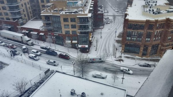
Four inches of snow has fallen in Arlington, according to the 2 p.m. snowfall total at Reagan National Airport.
The snow has led to slippery roadways and numerous closures. Though above-average temperatures and dogged work by Arlington and VDOT crews has resulted in many main roads being more wet than snow-covered as of mid-afternoon, a number of accidents and spinouts have been reported.

Most roads in Arlington have become snow-covered throughout the course of the morning as the D.C. area’s first — and likely last — big snowstorm of the season continues.

(Updated at 3:45 p.m.) A Winter Storm Warning is set to take effect overnight tonight, as a snowstorm bears down on the D.C. area.
Forecasters say 4-8 inches of heavy snow accumulation is likely for Arlington and the immediate metro area, though even snow is possible.

Throughout Virginia today, TVs and weather radios broadcast a test Tornado Warning as part of the annual Statewide Tornado Drill.
Anyone watching cable TV saw programming interrupted by Emergency Alert System message. A computerized voice said the Tornado Warning was just a test, but in a real weather emergency anyone seeing the EAS message should get to a basement or other secure location.

(Updated at 5:15 p.m.) A Winter Storm Watch has been issued for the D.C. area as Arlington County crews prepare for several inches of snow.
The storm is expected to start as rain tomorrow, the first day of spring, before transitioning to snow. The National Weather Service noted on its Twitter page that there is “lots of uncertainty” in terms of the type of precipitation.
A wintry precipitation mix is expected to hit the region this evening (March 6) and continue into tomorrow morning, which Virginia Department of Transportation officials say could impact the morning commute.
Crews are treating the roads and are preparing for any necessary snow removal, though a tweet from the Capital Weather Gang notes that it is unlikely that much will stick. It’s more likely that there will be a buildup of slush.

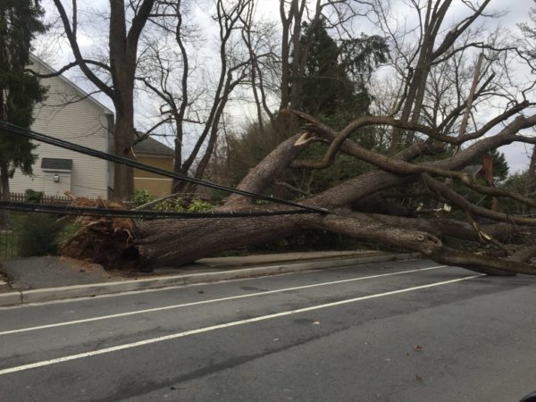
(Updated at 7:35 p.m.) Friday’s wind storm has taken a toll on Arlington, sending trees toppling onto cars, houses and across roads, and knocking out power to tens of thousands.
As of 7:30 p.m., Dominion reported 14,663 customers without power in Arlington. An hour earlier, it appeared that the numbers were finally dropping, but thanks to continued strong winds it has, in fact, gone up.

The westbound lanes of Columbia Pike are temporarily closed due to damage to the outside of the Arlington Cinema Drafthouse (2903 Columbia Pike).
On traffic cameras, the front panel of the Drafthouse’s marquee sign, which announces upcoming acts, could be seen dangling precariously in the wind. Firefighters are currently working to secure it and reopen the roadway ahead of rush hour.

(Updated at 1:10 p.m.) Today’s wind storm has caused tree carnage throughout Arlington County.
As of 12:30 p.m. firefighters responded to seven calls for trees that had fallen on houses, according to the Arlington County Fire Department, but no injuries were reported. The department has responded to another 31 calls for wires down over the past 12 hours or so.
(Update at 10:50 a.m.) More than 10,000 Dominion customers are currently without power in Arlington, according to the company’s website.
Numerous reports of downed trees, branches and power lines around the county have been rolling in over the past few hours as today’s “high impact” wind storm continues to roar across the D.C. region.

High winds are expected to wallop the Washington region tonight through Saturday and officials are asking the public to take precautions.
Wind gusts as strong as 60-70 miles per hour are possible from Friday from 4 a.m. through midnight, forecasters say. Wind gusts over 30 miles per hour are expected generally from tonight into Sunday.