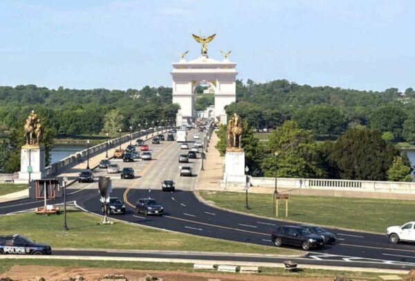
A sewer repair company put a price on dealing with federal and state agency permitting processes and working on high-traffic roadways.
That price tag is just over $2.6 million.
Arlington County is poised to pay that extra sum, conceding that the location of the project in question presents “unique challenges.”
To repair an “essential part” of the county’s sanitary sewer system — dubbed the Spout Run Deep Sewer Line — the selected contractor, AM-Liner East, will have to navigate distinct permitting processes and regulations for the National Park Service and the Virginia Dept. of Transportation.
This pipe carries “a significant amount of flow” from federally protected land, and along Langston Blvd and I-66, with the pipe reaching depths up to 115 feet below ground, according to the county.
After getting permission from NPS to work on protected parkland, the contractor will seek state permission once it hits I-66. It will be working on a narrow median and shoulder of I-66 and multiple travel lanes in both directions on Langston Blvd.
“It is believed that the bidders perceived significantly more risk in these bid items, which County staff consider fair given the unique challenges of this project area,” per the report.
For these reasons, AM-Liner East — the lowest responsible bidder — still exceeded expected project costs of $5.3 million. The Arlington County Board is scheduled to approve a $7.9 million contract, plus a $1.2 million contingency “for change orders or increased quantities,” at its upcoming Saturday meeting.
The proposed project generated what the county described as significant interest from nine contractors specializing in trenchless sewer rehabilitation. Only two bid on the project, however — a testament to its perceived challenges.
“For the work on federal lands and in VDOT right-of-way, the contractor will have to comply with restrictive NPS and VDOT permit requirements, respectively, and perform all restoration as per each agency’s specifications, which differ greatly from each other and from the County’s specifications,” the report said.
Arlington County says it identified this 86-year-old sewer line for repair in 2019 after a video inspection “revealed corrosion of the concrete pipe, indicated by exposed aggregate, exposed reinforcing steel, infiltration at the pipe joints, and small cracks.”
The project is part of the county’s program to rehabilitate critical large sewers, which are part of Arlington’s 465-mile sanitary sewage system. This project will start at Spout Run, north of the N. Courthouse Road cul-de-sac and end at N. Nash Street.
“This intricate network exists to make sure that the wastewater that gets flushed every day from homes and businesses makes its way to the Water Pollution Control Plant where it’s properly cleaned and treated before being recycled back into the environment,” the project webpage says.
For this project, AM-Liner East will use a trenchless technology known as cured-in-place pipe lining, which is seen as a relatively quick way to fix pipes with little or no digging involved.
A flexible liner is inserted into the pipe, inflated and exposed to heat or ultraviolet light to harden it and create a new, smooth surface inside.
To ensure this is done without disrupting existing flow, the contractor will install a temporary bypass. The bypass will be above-ground through residential grass areas along N. Uhle St, the Custis Trail and one lane of Langston Blvd. It will go underground near street crossings, such as at N. Scott, N. Quinn and N. Nash streets.

The National Park Service is starting to work on plans to improve safety along the portion of the Mount Vernon Trail that winds through Arlington County.
South of the City of Alexandria, in Fairfax County, it will make similar improvements to the trail and reconstruct that portion of the GW Parkway.
The 18-mile Mount Vernon Trail runs from Mount Vernon in Fairfax County to Roosevelt Island near Rosslyn, passing by Crystal City as it parallels the GW Parkway. NPS says it is time to address deferred maintenance needs and safety along the entirety of the 18-mile Mount Vernon Trail and the southern portion of the 15.2-mile GW Parkway.
“The road and trail improvements being considered would enhance the visitor experience for drivers, pedestrians, and cyclists,” the NPS project webpage says. “Potential improvements to the road include the implementation of a road, crosswalks and intersection changes. Potential safety enhancements for the trail would include potential trail widening and intersection improvements.”
Plans to widen the trail come two years after a report was released recommending this change due to heavy use and crash risks.
“The MVT is beginning to show its age, from deteriorating pavement and bridges, to limited accessibility features, and outdated signage and striping,” the report says. “These attributes, combined with increasing usage and user behavior, contribute to risk exposure and considerable crash history.”
For instance, from 2006-10, there were 225 reported bike and pedestrian crashes on the trail.

The report also found the trail has “meandering curves, timber bridges, and in some areas, dense vegetation.”
While controlled by the National Park Service, over time local volunteers have stepped up in an attempt to keep it clean and safe for users amid sparse maintenance from the park service.
NPS says it aims to provide solutions that maintain the parkway’s “scenic and historic character,” and an assessment will determine the potential environmental impact of the changes.
“The Plan is needed to help preserve the historic parkway for future generations, improve the visitor experience, reduce annual park operations and maintenance costs, and improve visitor safety,” writes GW Parkway Superintendent Charles Cuvelier in a public notice of an upcoming meeting about the project.
A virtual public meeting presenting initial plan alternatives will be held on Dec. 6 from 7-8:30 pm. There is no need to pre-register.
“Engaging with you is a critical part of our preliminary engineering and planning process,” the press release said. “Your feedback will be used to refine project designs and to support the analysis of any environmental impacts.”
The website has more information on how to join the meeting:
At the time of the meeting, click the link to join on your computer or mobile device and enter the Webinar ID (Webinar ID: 314-024-315) and your email. If you do not have Go-To-Webinar, you will be prompted to install a small file to your computer or download the app on your mobile device.
You can call into the meeting (no video) using the toll-free phone number and conference ID:
Call in number: (877) 309-2074
Phone Conference ID: 278-447-448
After the meeting, comments will be accepted from Dec. 6 through Jan. 4, 2023.
NPS last made changes to this stretch of the parkway and trail in 2012 to improve safety near the Memorial Circle and at several crossings. Changes included replacing signs, installing rumble strips, painting directional symbols and moving a crosswalk.
Although the plan’s scope only addresses the stretch of the Mount Vernon Trail through Arlington, the GW Parkway through Arlington sees its fair share of crashes.
Less than a week ago, a car drove off the GW Parkway and into the Potomac River near Columbia Island Marina and the Humpback Bridge. One occupant died and the other occupant was hospitalized.
One hotspot on the GW Parkway, near Key Bridge, frequently sees overturned vehicles during rainy weather.
The park service is currently in the midst of a major rehabilitation of the northern section of the GW Parkway that passes through Arlington and Fairfax County.

Trash Collection Starting Earlier — “In an effort to get a jump on the day and maybe beat a bit of summer heat, curbside collection crews will be starting their routes 30 minutes earlier in the morning beginning next week. The new start time of 6:30 a.m. is considered a pilot, with the results to be evaluated after a few months. As usual, recycling/trash/organics carts need to be at the curb by 6 a.m. on weekly pick-up day. Putting them out the night before is perfectly fine–if that’s how you roll.” [Arlington County]
Bezos Space Firm Has Arlington Office — Blue Origin “has a small existing office at 1530 Wilson Blvd. in Arlington… which the Blue Origin website describes as its ‘East Coast business office supporting government relations, sales and business development efforts.’ A lobbying disclosure form filed last month with the federal government also puts Blue Origin’s presence at that address. The Rosslyn office will remain open after Blue Origin occupies its new Reston space.” [Washington Business Journal]
Prolific Arlington Architect Dies — “Fredrick Sheridan of McLean passed away at home on June 30th at the age of 95. Fred was President and a founder of SBE & Assoc, an Arlington architecture firm for over 55 years… He was an early and major contributor to the development of local building and zoning codes in Arlington, advocating for residents and landowners. His scope of work included more than 200 projects. Fred’s versatility of design expertise extended from Courtland Towers to the Monastery of the Poor Clares to Marymount University.” [Legacy]
Forestry Commission on ‘Missing Middle’ — “The Arlington County government’s Forestry and Natural Resources Commission… while saying it agrees that a broader range of housing options should be available in Arlington, seems to be joining a growing chorus that the proposed zoning alterations should be phased in over time, to see what works and what doesn’t, before being implemented throughout Arlington’s single-family neighborhoods.” [Sun Gazette]
Group Lauds Board’s Antisemitism Resolution — “The Arlington County Board has received praise from the American Jewish Committee (AJC) for adopting the International Holocaust Remembrance Alliance (IHRA) Working Definition of Antisemitism. Board members passed a resolution in support of the language in June.” [Sun Gazette]
Crystal City ‘Midsummer’ Production Reviewed — “If ‘A Midsummer Night’s Dream’ is only as enchanting as a production’s take on the mischievous fairy Puck and bumbling actor Bottom, then Synetic Theater is fortunate to count spellbinding performances from Ariel Kraje and Vato Tsikurishvili among its assets.” [Washington Post]
NPS Seeking Ideas for Daingerfield Island — “The National Park Service is soliciting public feedback for ideas to overhaul part of Daingerfield Island near Potomac Yard. The idea is to revitalize the area around the Washington Sailing Marina at the former Indigo Landing Restaurant.” [ALXnow]
It’s Friday — Mostly cloudy during the day, then rain and possible storms at night. High of 86 and low of 73. Sunrise at 5:52 am and sunset at 8:37 pm. [Weather.gov]
There is a new sign of progress on the 30-year-old project to build a boathouse in Arlington.
In anticipation of planning and design work kicking off this year, the Arlington Boathouse Foundation — an organization that exists to ensure residents one day can launch non-motorized boats, such as kayaks, into the Potomac from the county’s shoreline — has launched a new website.
It is intended to provide frequent updates on the project’s progress as well as engagement opportunities, says foundation secretary George Kirschbaum. Those who need a refresher on the project, given how many years it has been discussed, will have easier access to important documents and answers to frequently asked questions, he added.
“We needed something new and fresh that’s more about the project,” Kirschbaum said. “Plus, we hope to provide some new interesting features, such as interviews with community members and interested parties to give their ideas and impressions of why this facility is important to the county and the residents.”
The website will also promote foundation-sponsored educational and promotional events, such as a river cleanup this June by the proposed lower portion of the site. Kirschbaum said foundation leaders hope events such as this one demonstrate the sustained community interest in the facility to project leaders.
Momentum has been building over the last year to build a boathouse at 2105 N. Lynn Street in Rosslyn. The project is a joint venture between Arlington County and the National Parks Service, as the county’s Potomac shoreline is NPS property.
Most recently, Kirschbaum said boathouse foundation leaders met with county officials, Rep. Don Beyer (D-Va.) and NPS representatives in December to discuss roles and responsibilities and how to keep the project moving forward.
This year, the county will solicit designs for the facility, to be comprised of two buildings: one near the entrance to the Key Bridge with locker rooms, workout areas, offices and meeting spaces, and the other at river level with storage for boat and stand-up paddle equipment, according to the boathouse website.
The county budgeted $4.75 million for planning and initial designs in the 2022-24 Capital Improvements Plan.
The project is popular with Arlington’s crew community, as it would provide them a more convenient boat launch that is away from D.C.’s crowded boathouses. Crew alumni and their friends also comprise many of the members of the Arlington Boathouse Foundation, which has pushed for the facility since 1991.
“It’s been a long process,” says Kirschbaum, who rowed for Washington-Liberty High School (then Washington-Lee) in the 1980s.
It didn’t gain momentum until 2012, when the parks service initiated an environmental impacts study — looking at how construction could affect floodplains and species living in the waterway. The study was held up several times before resuming in 2016 and wrapping up in 2018.
Meanwhile, the county purchased land south of the Key Bridge in 2014 to speed up the process and, despite some opposition, the Arlington County Board authorized an agreement with NPS in 2019.
“I think it’s important to know that the county has a very vested interest in working with the National Parks Service to see this through to fruition,” Kirschbaum said. “There are still high-level discussions about how are we going to work together to move forward, but those talks are happening… We can actually envision a boathouse where before, it was the dream.”
Kirschbaum says he hopes the boathouse will be ready if and when his currently elementary school-aged kid goes out for crew in high school.

For the first time since it was built in the early 1960s, the northern section of the GW Parkway will be getting a major overhaul.
The National Park Service announced yesterday that it had awarded a $161 million contract to rehabilitate the Parkway from Spout Run in Arlington to the Capital Beltway in McLean. After a design process in 2022, construction is expected to take place between 2023 and 2025.
Drivers are being cautioned that there will be traffic impacts during construction.
Rep. Don Beyer (D-Va.) touted the project in a statement, saying such work is overdue. This stretch of the Parkway has had to close at least three times over the past seven years due to sinkholes.
“The contract to repair G.W. Parkway’s northern section is a huge infrastructure win for our region,” Beyer said. “Northern Virginians have been pleading for major repairs to this section of the G.W. Parkway for years, as potholes and other damage accumulated over the past six decades put the parkway in ever-worsening shape. Thanks to legislation we passed in Congress and the Department of the Interior under Secretary Haaland’s leadership, we are finally going to get that fixed.”
“I also deeply appreciate the ongoing efforts of the National Park Service to improve safety on G.W. Parkway’s southern stretch,” Beyer added. “Together these projects deliver a top transportation objective for my constituents: making the historic G.W. Parkway as safe as it is scenic. The bipartisan Infrastructure Investment and Jobs Act will lead to so many projects that will benefit Virginia and the rest of the country as we deliver on the promise to rebuild America’s infrastructure.”
The full press release from the National Park Service about the coming rehab project is below.
A music-producing memorial tied to World War II received some fanfare this morning, as part of a restoration effort that began in 2019.
The towering Netherlands Carillon, located near the Marine Corps War Memorial and a short walk from Rosslyn, had its bells removed and shipped back to the Netherlands for restoration and tuning. The country gifted the memorial to the U.S. for its help during and after the war.
On Thursday morning, a new bell weighing over three tons was raised by a crane, in a ceremony that featured the U.S. and Dutch anthems as well as speakers including André Haspels, ambassador of the Kingdom of the Netherlands.
The hoisted George C. Marshall Bell is named after the former secretary of state who under President Harry Truman helped Western Europe rebuild with the Marshall Plan.
The bell, along with two other new bells, were cast in 2020 in the Netherlands.
The carillon was first installed in D.C. in West Potomac Park before being relocated next to the war memorial in Arlington in 1960.
The three new bells will make it a grand carillon — a term for the musical instruments that have more than 50 bells.
The other two bells will be added later, and the National Park Service expects the restoration to be complete by this fall. Those other bells are being named in honor of civil rights activist Martin Luther King Jr. and First Lady Eleanor Roosevelt.
(Updated at 10:55 a.m.) After a pandemic winter, the region’s annual rite of spring is finally here: The cherry blossoms have bloomed.
A string of warm weather days got the famed Tidal Basin cherry blossoms to hit peak bloom a few days earlier than initially predicted. While there were fears that peak bloom would result in crowded conditions that would prompt the National Park Service to shut down access, that has yet to materialize.
As of now, the Tidal Basin remains open with peak bloom expected to last about a week.
If blossom peeping is what you’re after, then Arlington National Cemetery is another possible destination, with numerous cherry blossom trees. However, it’s currently only open to the public on a limited basis.
Here in Arlington, our cherry blossoms aren’t as famous as those across the river, but there are still plenty to see elsewhere around the county. Clusters of cherry trees and blossoms can be seen in various Arlington neighborhoods, heralding the arrival of spring without the fanfare of their Tidal Basin brethren.
ARLnow staff photographer Jay Westcott traveled around Arlington over the past week to capture some of the blooms, as seen in the gallery above.
There are other ways to participate in the cherry blossom festivities that don’t require venturing across the Potomac.
In National Landing, where dozens of cherry trees are being planted, two “Art in Bloom” sculptures are now on display. Relatedly, Amazon is now a top-level sponsor of the National Cherry Blossom Festival.
Arlington restaurants are included in the annual “Cherry Picks” program, which highlights cherry blossom-inspired dishes.
A new addition to the festival is the “Porch Parade and Pedal Procession,” in which area residents and businesses decorate their porches, yards, and windows with a cherry blossom theme. Arlington is home to numerous such displays, according to a map.
Some Arlington neighborhoods, including the Aurora Highlands community near National Landing, are even organizing their own cherry blossom activities this year.
Check-out some very enjoyable
citizen-organized neighborhood activities too #cherryblossoms https://t.co/HeenQ1Q8u9— Takis Karantonis (@TakisKarantonis) March 30, 2021
(Updated at 1:45 p.m.) After two years of construction, the Arlington Memorial Bridge is completely open for drivers, pedestrians and bicyclists.
The 90-year-old bridge, which connects Arlington National Cemetery and the Lincoln Memorial, was renovated to save it from potentially closing for good in 2021. The $227 million rehabilitation project, one of the largest infrastructure projects in National Park Service history, will give the bridge another 75 years of service, officials said on Friday.
According to NPS, although the bridge is officially open, workers will continue putting final touches on the bridge and the Memorial Circle, replanting staging areas, completing small projects on the deck and installing bird netting.
In addition to the heavy infrastructure work on the bridge, a key Potomac River crossing, NPS repaved, improved crossings, added new signs and made the area easier and safer for drivers, pedestrians and bicyclists to navigate, officials said.
The overhaul closed lanes and created traffic headaches for the 68,000 daily commuters that use it — by pre-pandemic counts, at least.
Local members of Congress — including Sens. Mark Warner and Tim Kaine, Reps. Don Beyer and Gerry Connolly and D.C. Delegate Eleanor Holmes Norton — pushed for funding the project, after the discovery of corrosion led officials to close outer lanes and impose a weight limit.
In a joint statement issued Friday, the lawmakers said they worked to save the bridge because a closure would hurt their constituents.
“Memorial Bridge is now fully operational, and stands not only as a historic and functional monument, but also as a symbol of the kind of progress that is possible on rebuilding key transportation infrastructure through smart government investment,” they said in a statement.
Warner added that the project’s funding only came together as a result of a long-running, concerted effort among lawmakers and local officials.
“In 2015, we were warned that Memorial Bridge — a critical artery between Virginia and the nation’s capital — was literally falling apart,” said Sen. Warner. “Today’s reopening is a testament to years of work by the region’s congressional delegation, our local partners, and the National Park Service. Commuters can now rest easy knowing that this nearly 90-year-old landmark will carry them safely over the Potomac for years to come.”
The completed project preserves a national memorial to the sacrifices of veterans, U.S. Secretary of the Interior David L. Bernhardt said.
“The completion of this project marks one of the largest infrastructure projects in National Park Service history, which was done on time and on budget,” Bernhardt said. “I hope that all Americans are brought together to remember and honor our veterans every time they cross this bridge into the capital of our nation.”
Flickr pool photo (top) by Kevin Wolf, photo (bottom) courtesy of Office of Sen. Mark Warner
Local Dog Adoption Demand is High — “Kim Williams, who volunteers for the Lost Dog and Cat Rescue Foundation of Arlington, Virginia, has tapped into a puppy pipeline of sorts to bring some of Georgia’s homeless pet population to the mid-Atlantic region where they are bombarded by requests for dogs to adopt.” [WMAZ]
American Reducing Service at DCA — “American Airlines is discontinuing service to more than 20 destinations from Reagan National Airport in January, according to new data reported by the Official Airline Guide. Cities and/or airports dropped range from major (New York-JFK; Las Vegas; St. Louis; Minneapolis-St. Paul) to smaller (Jackson, Miss.; Manchester, N.H.; Greensboro, N.C.). Many were served just once or twice per day.” [InsideNova]
Land Transfer May Speed Bridge Project — “Interesting: NPS is ‘supportive’ of conveying four acres of parkland to VA and DC to construct the Long Bridge(s), rather than just permitting. That would likely speed design and construction, and could result in a ped/bike span that doesn’t compromise as much on width and lighting in order to conform to NPS interests.” [@CarFreeHQ2/Twitter]
Local Wildlife Caught on Camera — “Arlington resident Levi Novey and his wife Alicia have captured footage documenting quite an array of critters passing through their yard via a fence that Levi has dubbed a ‘wildlife superhighway…’ So far their fence camera has photographed foxes, raccoons, mice, housecats, chipmunks, and lots of birds and possums.” [WJLA]
Redistricting Commission Applications Open — “Beginning Monday, Virginians will have a month to apply for one of eight public seats on the state’s new redistricting commission, which has begun its work with a panel of retired judges setting out plans for the application process.” [Washington Post]
Stormy Day Today — “Get ready for a wild weather finish to November. A strong storm system develops and moves through… bringing a mix of hazards to our area in a short time frame, capped off by the potential for strong to possibly severe storms Monday afternoon. No specific warnings or advisories have been issued, but expect a good soaking of one to two-plus inches of rain (and some wild temperature swings).” [Capital Weather Gang, Twitter]
Portions of the Mount Vernon Trail in Arlington should be widened due to heavy use and crash risks, according to a new study.
The National Park Service this month released a report on its Mount Vernon Trail Corridor Study, which examined the condition of the trail, usage patterns and potential improvements.
The trail, which runs along the Potomac from the Rosslyn area to George Washington’s Mount Vernon estate, is used by more than one millions cyclists and pedestrians per year. But its 1970s-era design no longer reflects current engineering standards and the trail’s heavy usage, the report says.
“The trail is relatively narrow by modern standards, and characterized by meandering curves, timber bridges, and in some areas, dense vegetation,” says the report. “The MVT is beginning to show its age, from deteriorating pavement and bridges, to limited accessibility features, and outdated signage and striping. These attributes, combined with increasing usage and user behavior, contribute to risk exposure and considerable crash history.”
There were 225 reported bike and pedestrian crashes on the trail between 2006 and 2010, according to the study. Many of those were at crash hotspots along the trail in Arlington, including near Reagan National Airport, Gravelly Point and the 14th Street Bridge.
“Trail intersections, roadway crossings, surface transitions, and blind curves along the MVT were associated with higher crash and injury rates,” the report says. “On average, the MVT experiences one ambulance call per week related to a bicycle or pedestrian injury.”
“Collisions are more likely to involve male bicyclists (although males are typically overrepresented in the bicycling community),” the study also notes.
Reported crash injuries range include lacerations, bone fractures and head injuries, attributable to both single-person wrecks and collisions between trail users.
Among the near-term (1-4 year) improvements recommended in the report are new way-finding signs, increased trail maintenance, reduced-slip surfaces on bridges, and new “slow zones” at certain points on the trail.
“‘Slow zones,’ including the appropriate signage and pavement markings [could] be used at areas of high conflict among different trail users (e.g., at Arlington Memorial Bridge, Belle Haven Park, Gravelly Point, and other appropriate locations),” the report says.
The recommendations for medium-term changes — potentially 5-7 years away — are more drastic.
The study recommends that portions of the trail in Arlington be reconstructed and widened to at least 11 feet, in accordance with modern multi-use trail standards, compared to the current average 8-9 foot width. Another possibility: separating cyclists and pedestrians in high-traffic areas like Gravelly Point.
That’s in addition to improved trailheads at Crystal City and Gravelly Point, with “more bicycle parking, repair stations, and additional amenities.”
More from the report:
Widening the trail to meet this standard improves trail safety by providing appropriate width to minimize user conflict in high-traffic areas. Focus areas for widening and modernization include:
- The portion of the trail located between Four Mile Run and the Theodore Roosevelt Island Bridge, pursuant to NEPA analysis. Some segments of trail in this area face widening constraints, but much of this high-use segment could be widened to better align with best practices and serve trail users.
- Trail intersection enhancements, such as implementing trail roundabouts, at the 14th Street Bridge and Four Mile Run to better manage these conflict areas by slowing bicycle traffic and reducing conflict points.
- Consider the use of bicycle-pedestrian separation at areas such as Gravelly Point, which have high levels of user conflict and pedestrian use. This could include a designated pedestrian path or increased separation and access control between the trail and adjacent site. A potential trail redesign in this location could also reduce motorist and trail user conflict at the trail intersection with the Gravelly Point parking lot.
A Mount Vernon Trail widening might not sit well with some local activists. A similar proposal, to widen portions of the W&OD Trail in Arlington and provide separate lanes for cyclists and pedestrians is facing opposition from some who have expressed environmental concerns.
A stone’s throw from Crystal City is Roaches Run, a waterfowl sanctuary on the northern flight path to and from Reagan National Airport.
The body of water, surrounded by woods, is home to birds, ducks and dragonflies. Accessible primarily from a small parking lot off the southbound GW Parkway, most human activity is confined to fishing and birdwatching.
But that may eventually change.
Arlington County Board Chair Libby Garvey toured a portion of woods around Roaches Run last week with the chair of Arlington’s Planning Commission and representatives of Crystal City property owner and Amazon landlord JBG Smith.
Even on a rainy day @jbgsmith and chair of Planning Commission see opportunity Roaches Run has for trails, boating and more @crystalcityva pic.twitter.com/DmxU4zmlbB
— Libby Garvey (@libbygarvey) February 27, 2020
Though Roaches Run is controlled by the National Park Service and is part of the GW Parkway, JBG owns parcels of land adjacent to the waterfowl sanctuary and could help link it to Crystal City. That would give the rapidly-developing neighborhood newfound accessibility to natural spaces.
“JBG owns a lot of the land over there and is in communication with the Park Service,” Garvey told ARLnow, noting that the developer invited her to last week’s tour. “Can we take this land and turn it into an accessible, usable space for people?”
Garvey said Roaches Run is “a lost area” that’s “not very accessible for anybody” at the moment. Active railroad tracks currently separate it from Crystal City and Long Bridge Park.
JBG declined comment for this story.
Among the ideas for Roaches Run are walking and biking trails, a floating dock for boaters in canoes or kayaks, and bird observation stations. Roaches Run would remain a nature preserve, however, and is not envisioned for other sports or recreation uses.
“It’s going to take some cooperation” to see this idea come to fruition, Garvey said.
The county, the Park Service, JBG and even the Metropolitan Washington Airports Authority would likely be involved. That’s not to mention local civic associations, which have floated the idea of establishing connectivity to Roaches Run from Long Bridge Park and the Mt. Vernon Trail as part a series of improvements to the Crystal City and Pentagon City are dubbed Livability 22202.
“I think it’s an advantage for everybody…. making that whole area spectacular for people,” Garvey said. “You could get on an airplane and go hiking and boating within a mile radius.”
While discussions about Roaches Run have been informal in nature so far, with Amazon moving in nearby and demand for recreational opportunities growing it’s likely to advance to a more formal planning process at some point in the near future.
“It’s all very tentative but this is how ideas start, you have to start somewhere,” Garvey said. “Nothing is happening tomorrow or even next year… it’s probably 5-10 years out.”
Map via Google Maps