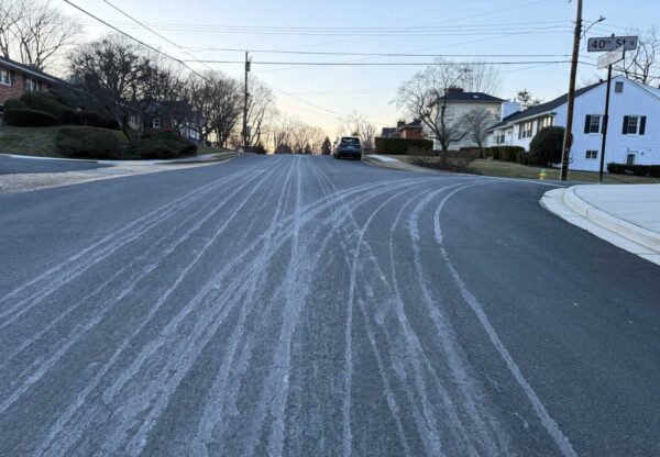
(Updated 3:40 p.m.) Work is ramping up on a new Arlington County bus maintenance building and parking garage in Green Valley.
Crews are set to wrap up laying the foundation for the Arlington Transit (ART) Operations and Maintenance Facility at the end of this month, says Dept. of Environmental Services spokeswoman Alyson Jordan Tomaszewski.
“The facility will perform regular preventive bus maintenance, repairs and other unscheduled maintenance work,” per a project webpage. “It also will include administration and operations functions and parking for buses and staff.”
Then, passers-by may notice a crawler crane on site, which will be used to install steel columns. That work is set to last until sometime in March, according to the project webpage.
Meanwhile, work on the foundation of the parking garage is planned to start at the end of January, she says.
Construction began in June 2022 and is expected to be completed in the fall of 2024.
“We have experienced both weather and supply chain delays with the ART Operations and Maintenance Facility,” she said. “However, we are still on track for completion in fall 2024. To mitigate the supply chain issue, we are expediting material approval and procurement as best we can.”
ICYMI: Foundation and other infrastructure taking shape at the ART Operations and Maintenance Facility site along Shirlington Road. Work proceeds through next year. https://t.co/d6DdG1ZpQD pic.twitter.com/WNFKcZ0Oz8
— Arlington Department of Environmental Services (@ArlingtonDES) January 16, 2023
The Green Valley Civic Association welcomes the new facility.
“The county used to park about 60 ART buses right in Jennie Dean Park, next to the basketball court,” Robin Stombler, community-affairs chair of the civic association, tells ARLnow. “Moving the buses into a new operations facility adjacent to I-395 is not only a welcome change, but should mitigate noise and light disturbances on the residential community.”
Still, the civic association has some lingering concerns.
“We were vocal on the need for improved environmental conditions. This meant a state-of-the-art facility outfitted for a future electric bus fleet, better stormwater management and bioretention ponds, and lit signage that does not face the residential part of Green Valley,” Stombler said.
“The new county bus campus will house a staff-only, multi-story parking garage,” she continued. “We need some creative thinking to make sure this amenity is shared with the rest of the neighborhood.”
Next door, the general manager of the Cubesmart storage facility tells ARLnow that the county has “been very sensitive to the fact that we have traffic flowing in and out of there and has done great job keeping the road clean.”
The Cubesmart opened a second facility near the construction site back in March 2021. Between the original building, now “The Annex,” and the new building, there are nearly 2,400 storage units, she said.
This construction project follows on the heels of other recently completed ones in the Green Valley neighborhood, aimed at realizing a community vision of an arts and industry hub. The new John Robinson, Jr. Town Square, with a towering sculpture, as well as the renovated Jennie Dean Park opened with great fanfare this spring.
The County Board approved the purchase of the three parcels in Green Valley to build the ART facilities back in 2018.
“This project is essential for ART’s long-term sustainability and will address the current and future needs for parking, operations and maintenance of the County’s growing ART bus fleet,” according to the project webpage. “ART has significantly increased its number of routes and hours of service during the past 10 years and plans to continue growing during the next 20 years, supported by a fleet of more than 100 buses.”
The total cost to buy the land, plan and design the project and construct it is $81.2 million.
Work hours are 7 a.m. to 9 p.m. on Monday through Friday, with some weekend work occurring between 10 a.m. and 9 p.m.
This article was updated to add comments from the Green Valley Civic Association.
Drivers have been blocking a new PBL in search of the perfect PSL.
Last November, as part of a 2022 Complete Streets project, Arlington’s Dept. of Environmental Services replaced two parking spots with a protected bike lane, or “PBL,” on the east side of Clarendon Blvd. It also added new free, 15-minute parking spots at N. Danville Street, to accommodate those who would have used the two former spots when picking up their coffee order from the nearby Starbucks.
“All those legally parked automobiles are actually protecting bikers who are using the bike lane to the right,” noted DES spokesman Peter Golkin.
But illegally parked vehicles caused a different problem. Flouting a no-parking sign, cars — and even a county pickup truck — parked where the spots used to be, partially or completely blocking the bike lane. Local cyclist Jeff Hopp said he saw cars blocking the bike lane “all day, every day,” to access the Starbucks location across the street from the Whole Foods.
“In the area near Starbucks, [the county] created a hazard to cyclists instead of a safe PBL,” he said. “The county removed two parking spaces in the area when creating the PBL but the design of the PBL at this spot allows for drivers to drive into and park in the PBL while they ‘run in’ to Starbucks to grab their drinks.”
Public feedback helped guide the designs, Golkin says, but in response to the reality on the ground, the county recently made it harder to park there.
“Extra bollards were added this month to make such an abuse less tempting and to encourage drivers to look for the free and pay spaces just a few feet down the road,” Golkin said.
Several free 15-minute parking spots can be found on Clarendon Blvd at Danville along the new protected bike lane. A few more PBL bollards can be found just to the west. https://t.co/WBOtOpfRPh pic.twitter.com/wEz2z32F8n
— Arlington Department of Environmental Services (@ArlingtonDES) January 17, 2023
Hopp, who had notified the county about the issue, says he appreciates the changes.
“I feel the county was responsive to a conversation about a solution and, in the end, I feel they made the right decision to install additional bollards around the edges,” he said. “With these additional bollards, vehicles will not have enough room to pull into the PBL in this area — unless drivers just mow them down, which I’ll bet has happened before.”
(Updated at 12:40 p.m. on 8/16/23) A portion of Columbia Pike is set to close for more than a year later this month to help make way for Arlington National Cemetery’s expansion.
The half-mile section of Columbia Pike between S. Joyce Street and the Virginia Department of Transportation (VDOT) facility just east of S. Oak Street is expected to be shuttered starting Monday, Jan. 23.
It will remain closed until the summer of 2024.
The closures are part of the Federal Highway Administration’s Arlington National Cemetery Defense Access Roads (DAR) project that’s being done to accommodate the 50-acre southern expansion of Arlington National Cemetery (ANC).
This will add about 80,000 burial sites, allowing the cemetery to continue burials through the 2050s. The expansion will also bring the Air Force Memorial within cemetery grounds as well as provide space for the 9/11 Pentagon Memorial Visitor Education Center, with construction on that currently slated to start next year.
The overall expansion project remains on track to be completed by 2027, an ANC spokesperson confirmed to ARLnow.
Some detour specifics for the Pike closure are expected to be announced in the coming days, though the ANC spokesperson did share the general plan via email.
Traffic will be redirected to travel north on a new segment of S. Nash Street that will be opened between Columbia Pike and Southgate Road and one block east of S. Oak Street. It’s marked as a “new access road” on the map below.
Then, to circumvent the closed portion of the Pike, traffic will be sent east on Southgate Road to the existing S. Joyce Street/Columbia Pike intersection, which will remain open.
For pedestrians and cyclists, there is set to be a “dedicated” sidewalk with a buffer zone and barricades. Those “are currently being constructed in anticipation of the 1/23 closure,” the ANC spokesperson said
At the moment, there is an established pedestrian and bike detour along the north side of Southgate Road as well as a temporary sidewalk to the east of S. Joyce Street that connects with the sidewalk under the I-395 bridge.
Last week, though, a reader reached out to ARLnow about how a portion of the pedestrian and bike detour has a “large patch of gravel” rendering it not accessible for some.
“While a wheelchair user might be able to make it across that patch, it wouldn’t be easy,” they wrote. The reader said that locals have reached out to the Federal Highway Administration (FHWA) about the gravel but, so far, little has been done.
Local officials told ARLnow that they have since addressed that patch of gravel.
After a slight weather delay, the second leaf collection pass will start tomorrow (Tuesday).
Arlington County initially posted the second vacuuming could start on Saturday, Dec. 3. Despite the delay, the county aims to finish sucking up dead leaves before Christmas.
“Collection is currently a day or two behind because of recent winds and rain prompting heavy leaf fall but that’s not uncommon and the schedule has some built-in flexibility,” Department of Environmental Services spokesman Peter Golkin. “The end target of Dec. 21 remains on schedule.”
Routes are run Monday through Saturday, according to the county website. Residents can see when their neighborhood is scheduled for services online and can reference an interactive map to track the department’s progress.
Roughly 2,500 tons of leaves were collected during the first pass, which wrapped up Saturday, the DES spokesman says.
“That’s more leaves than the total 2,736 tons for all of last year but less than the 5,706 total tons picked up for all 2020 and the 6,696 total tons in 2019,” he said. “Hard numbers from weighing the leaves won’t be in until the vacuum second pass schedule is completed the second-to-last week of December.”
This year, Arlington County started leaf collection on Nov. 14, a week after last year’s scheduled start, potentially meaning an extra week for curbside leaf piles to get large and soggy.
In response to the change, more than a third of readers said that was too late, according to an unscientific ARLnow poll. On the other hand, a majority said the later start wasn’t a problem: 38% said the current schedule is fine and about a quarter said it should start later.
It appears the later start, determined by Solid Waste Bureau chief Erik Grabowsky and his team of “tree whisperers,” was not a problem for crews.
“As we say on the website, they use ‘historic data, tree types and density, weather forecasts, state forestry forecasts and resident feedback’ to set the schedule and it works out well,” Golkin said.
DES provided these leaf tips for residents preparing for collection:
- Leaves need to be waiting at the curb by the date on the orange signs posted throughout each neighborhood and the first date, NOT the end date, for each neighborhood on the schedule
- Leaves can also go in the green curbside cart (along with food scraps) and paper bags for year-round weekly collection; never use plastic bags for yard waste because those can’t be composted and won’t be collected
- Free paper yard waste bags are available while supplies last (maximum of 15 per resident) at several County facilities
A number of options have emerged for upgrading an iffy portion of the Arlington Blvd Trail.
Engineers found it would be possible to accommodate a trail up to 11 feet wide with buffers and guardrails, between the bridge to Thomas Jefferson Middle School and George Mason Drive. That could be accomplished by narrowing a few on- and off-ramps, closing slip lanes and reducing the number of thru-lanes and turn lanes in some places.
This summer, Arlington County asked trail users how they feel navigating the 1.3-mile stretch of the trail, which runs along the busy and congested six-lane Route 50. Many said they feel unsafe due to bicycle, pedestrian and vehicle conflicts and the lack of buffer between the trail and vehicle travel lanes.
“It’s not very welcome to users. It feels narrow, it’s not continuous and there are poor pavement conditions,” Arlington County transportation planner Bridget Obikoya said in a Nov. 17 meeting. “We want to develop design concepts that improve the existing conditions, such as widening key pinch points and removing barriers and obstructions, improving connectivity and making the trail overall a much more pleasant place to be.”
Over the years, several plans have recommended improvements to the Virginia Department of Transportation-owned trail, which runs east-west from D.C. through Arlington to Fairfax County and bisects a 16-mile bike loop ringing the county.
The 2022-24 Capital Improvements Plan allocated $200,000 to study potential intersection improvements and accessibility upgrades to the area, which has a number of destinations: Thomas Jefferson Middle School and community center, Fleet Elementary School, the National Foreign Affairs Training Center, the Columbia Gardens Cemetery and several churches.
Despite these features, there isn’t much of a trail, and sidewalks are not continuous, says Jim Sebastian, an engineer with Toole Design, a firm that studied the corridor and developed the proposed changes.
“It is challenging, but it’s also exciting thinking about some of the improvements we can make to allow biking and walking to be a little more safe and comfortable,” Sebastian said.
The 1.3-mile stretch was broken into seven segments, four on the north side of Route 50 and three on the south side.
All but one segment has two proposed alternatives, and details of these proposed alternatives can be found in a presentation and explained in a recorded online meeting.
Residents can share their feedback on the proposed alternatives through Monday, Dec. 5. There will be pop-up events along the trail corridor, hosted by the county and local churches and other community destinations.
“This is extremely preliminary,” Nate Graham, a DES public engagement specialist, said in the Nov. 17 meeting. “This is an opportunity… to hear what parts you prefer and develop some combination of first and second alternatives between these seven segments to meet the goals of this project and serve the needs of the community.”
The study found that accommodating the trail, along some segments, could require changes to vehicle traffic.
For instance, between Glebe Road and George Mason Drive, one alternative calls for the closure of the off-ramp slip lane west of N. Thomas Street. The connection between the service road and George Mason Drive would also be closed, with traffic rerouted up to N. Trenton Street.
Arlington County has not ruled out the possibility of a permanent roundabout on Military Road despite the confusion a temporary version has caused for the past year.
In October 2021, where there used to be a stop sign for traffic on northbound Military Road, the county added paint lines, bollards and raised temporary curbs, and partially demolished a median. The work was aimed at improving safety where Military Road intersects with Nelly Custis Drive.
While preliminary data from the county found the roundabout did lower speeds, 53% of drivers, 27% of pedestrians and 26% of cyclists said they felt “less safe” or “much less safe” using the new traffic pattern, per a summary of feedback collected this summer.
“The majority of all respondents reported feeling less safe while using the pilot intersection, but the margins were very narrow for those who walked or biked through the intersection,” the report says. “Those who reported feeling less safe highlighted concerns with operational confusion, the size of the pilot roundabout and the perceived lack of sufficient space for a well-designed roundabout in the future condition.”
Drivers said they were confused about proper procedure in the intersection, while cyclists said drivers exhibited inconsistent behavior and would revert to habits they had when the intersection had a stop sign, per the report. Additionally, several users said the temporary materials caused visual challenges that contributed to the confusion.
About 31% of drivers, 26% of pedestrians and 18% of cyclists said they felt “safer” or “much safer” with the traffic circle, the summary says.
Road users in this camp were also concerned about confusion, but “reported better yield rates by vehicles to pedestrians, slower vehicle speeds, and easier operations for traffic flow and left turns from Military to Military,” the report said.
For now, it seems the roundabout is still in play as a permanent change.
The report says that the project can “take the form of either a signalized intersection or a roundabout” and that a majority of issues locals raised “can be addressed through design in a capital project, where the intersection design will not be limited by existing curb lines.”
Meanwhile, the Old Glebe Civic Association, which previously called the changes “unwanted” and says it has opposed the potential project for four years, says it has sources claiming the roundabout is all but a done deal.
“Two County staff members recently stated that the County will be building a permanent roundabout, which will take about 12 to 15 months, independent of the public feedback,” writes Peter Jaffe in the October edition of OGCA’s newsletter. “They said that the permanent roundabout will be larger than the temporary one and that the increased size will help address confusion by drivers about who is in the roundabout and who has the right of way.”
The report notes that recently, signs in the middle of the roundabout “have been knocked down and later repaired at least twice, suggesting that incidents have occurred at the roundabout.” The Old Glebe neighborhood is about 2 miles west of the roundabout, but Military Road is a popular commuter route for those heading east.
In response to OGCA’s letter, Dept. of Environmental Services spokeswoman Claudia Pors tells ARLnow there is no official recommendation yet.
“The County has not shared any recommendation or decision for the Military Road and Nelly Custis Roundabout Pilot Project at this time,” she said.
As for the signage, she said the team at DES is aware of the issue.
“Throughout the pilot’s duration, signage has been knocked over,” she said. “Staff has repaired or replaced these signs as soon as possible. We do not have information on the exact causes of these incidents or how many times they occurred.”
Arlington maintains a sizable network of traffic cameras, but a significant portion of those cameras have been “temporarily unavailable” in recent weeks.
It’s a problem that the county county is promising to fix.
The publicly viewable feeds of conditions on Arlington’s main roads help with real-time reporting on breaking news of crashes or hazardous driving conditions, such as heavy snow. The feeds also allow residents to check conditions before heading out.
Arlington County has more than 200 traffic cameras trained on its roads. As of last weekend, at least two dozen were out. A few weeks ago, in Pentagon City and Crystal City alone, about 40% of cameras were out, according to public safety watcher Dave Statter.
For comparison, it looks like only about 10% of the traffic cameras @VaDOTNOVA has along the entre length of I-395 in Virginia aren't working. That seems a lot more reasonable. https://t.co/RpSD8MWQ4G
— Dave Statter (@STATter911) October 21, 2022
Residents noted outages were an issue when the county moved the feeds from Trafficland.com to an in-house website back in 2015.
The outages have a variety of explanations, but the county is working on addressing them, according to the Dept. of Environmental Services.
“A camera feed can stop working for several reasons like equipment failure, communications issues, or planned construction,” spokesman Peter Golkin said. “Sometimes only a camera’s public feed is impacted while the internal feed continues. Although a single camera supplies both feeds, they can be independently impacted — especially in older analog cameras.”
Thanks for responding. Would also be interested in knowing what rules/guidance the County has issued on the operation of the cameras.
— Dave Statter (@STATter911) October 24, 2022
Public feeds are produced by the DES Transportation Engineering & Operations (TE&O) Bureau. Feeds are also shared internally with the county’s emergency services agencies.
He said while TE&O’s first priority is maintaining the internal feeds that support critical county services, given limited staff and resources, the bureau is “still stepping up its checks of the public feeds.”
“Many public feeds have been restored in recent weeks,” Golkin said. “To avoid confusion, staff are looking at ways to differentiate long-term, planned outages from temporary outages on the public website.”
The outages compound another issue: the county’s policy of censoring public feeds during incidents — from minor crashes to major public safety incidents. Turning off the feeds makes real-time reporting more difficult for ARLnow and other news outelts.
@ReadyArlington If you could rotate the traffic camera there that would be appreciated
— Arlington Now (@ARLnowDOTcom) October 21, 2022
Arlington says it controls what is relayed via traffic cameras during certain incidents to protect privacy.
“Arlington County upholds its values of transparency with public safety information beyond camera footage, including daily crime reports, press releases, emergency alerts, and EMS/fire event summaries,” the county said in a statement. “Camera access furthers our transparency but must be balanced with community privacy concerns.”
ARLnow was provided the following criteria that go into evaluating when to stop publicly broadcasting a traffic scene.
Cameras are diverted to protect:
- Health information: This includes identifiers related to a potential patient, like their face, demographics, and health condition. This is all protected information until the person is determined to no longer be a patient, which occurs after they sign a refusal to be assessed or transported.
- Law enforcement tactics and officer identity: The County protects the identities of law enforcement personnel who serve in plain clothes or undercover roles. Cameras may also be diverted during an active incident, such as an Emergency Response Team (ERT) response, to safeguard tactical information and ensure the safety of all present.
- Victim and witness privacy: Victim and witness privacy protection is always central, but especially if there are juveniles present — something responders wouldn’t know for sure until arriving at a scene. The County also seeks to protect victim and family privacy and dignity by diverting footage in a medical incident, especially when next of kin must be notified of a significant event.
It’s unclear how much identifiable information can be obtained, however, given the relatively lower resolution of the feeds.
Citing an “ongoing issue,” Arlington County has ticketed Advanced Towing multiple times in recent weeks for blocking “the most famous fire hydrant in Arlington County.”
Trucks from the Ballston-based towing company have received multiple tickets, including one as recently as last week, for parking and blocking a fire hydrant near the corner of 5th Road N. and N. Quincy Street, a county official has confirmed to ARLnow. They were not able to provide the exact number of tickets, however.
That particular hydrant, dubbed “the most famous fire hydrant in Arlington County” by former local news reporter Dave Statter, is in the alleyway next to the company’s lot. A Twitter account is devoted to documenting illegal parking in front of the hydrant.
The county says that they have “received social media complaints and emails from an anonymous account holder” about the issue.
.@AdvTowHydrant looks like you have a bunch from last 2 days, here are a few more from Fri night. @STATter911 @ARLnowDOTcom pic.twitter.com/bV26uACPUt
— Matthew Young (@matthewyoung31) October 29, 2022
On Saturday afternoon, the fire marshal was sent to talk with Advanced Towing about the “ongoing issue,” per scanner audio posted on social media by Statter.
Listen: The most famous fire hydrant in Arlington County getting some attention today from @ArlingtonVaFD fire marshal. @AdvTowHydrant @matthewyoung31 pic.twitter.com/yigMZtBZbn
— Dave Statter (@STATter911) October 29, 2022
The result of the ensuing conversation between the fire marshal and Advanced Towing appears to have rectified the problem for now. A spokesperson for Advanced Towing tells ARLnow via email that they’ve stopped parking in front of that hydrant.
However, the company also argued that the fire hydrant is inactive, on their property, and other cars are parking illegally in the alleyway but are not being ticketed.
“I feel the tow trucks are the only ones with attention, tickets and complaints when the entire area is constantly full of illegally parked vehicles because there’s is no parking,” the spokesperson said, while also providing photos of supposedly illegally parked cars. “No tickets have been issued.”
County spokesperson Ben Aiken did confirm that the specific hydrant is “redundant for fire purposes” with another hydrant only a few feet away, but did say it is operational and maintained “for other reasons as part of the water system.” There are also no plans to remove it.
The issue of Advanced Towing trucks parking in front of that particular hydrant apparently has been ongoing since at least 2017 per Twitter user Advanced Towing Fire Hydrant.
The #advancedtowing parking issue has been going on for years. These photos are from 8/22/2017. @ArlingtonVA @ArlingtonDES @ARLnowDOTcom #MissingManager pic.twitter.com/VRFwFKLPb4
— Advanced Towing Fire Hydrant (@AdvTowHydrant) November 3, 2022
While the company says the hydrant is on their property, the county noted that doesn’t give Advanced Towing — or any property owner — the right to park in front of a hydrant.
“The hydrant is located within 5th Rd. North right-of-way and parking is restricted within 15 feet of a fire hydrant,” Aiken wrote in an email.
Advanced Towing also complained about the lack of parking in the area, leaving their trucks often struggling to find spots near their lot, where vehicles towed for trespassing on private property are stored (and scene of a famous incident involving a television personality).
The company cited the move from free street parking to metered spots as well as the presence of the county-owned Mosaic Park as two main reasons for why parking is hard to come by in that corridor.
“This causes huge congestion on 5th Road and surrounding areas, therefore cars are parked illegally all day long. We will also be reporting every illegally parked vehicle we see,” they said via email. “This morning alone, there were 6 at one time, and not one was ticketed.”
A few weeks ago, seven-year-old Desmond Kelly was walking to school when he stepped on a utility cover and it collapsed.
“I didn’t know what to do so I put my arms out,” he said. “I was pretty shocked and amazed that I was able to catch myself before my feet hit the bottom.”
The fall happened at the northeast corner of S. Glebe Road and Arlington Blvd (Route 50), near Alice West Fleet Elementary School. His mother, Genevieve, said her son’s feet never touched the ground because the hole was so deep.
“It turns out that the cover gave way under his small body weight because it was made of rotted wood,” she said. “My son was agile enough to stick his elbows out to prevent himself from falling all the way through to the bottom of the hole and possibly breaking a leg.”
When Desmond’s mother reached out to ARLnow over the weekend, she noted the utility cover had yet to be repaired, although the issue happened several weeks ago.
“And other covers nearby look like they are about to cave in,” she said, including the utility cover at the southeast corner of the same intersection.
This cover is an access point for an underground fiber cable. Arlington County has about 1,700 “handholes” for fiber cable and other electrical cables linked to things like traffic signals or streetlights.
For issues with publicly and privately owned handholes — which are typically small and shallow, allowing workers to reach in and access the cables inside — the county in part relies on residents noticing and reporting issues through its Report-a-Problem tool. Using the online form, people can also bring attention to potholes, street light outages and make other maintenance requests.
This utility cover in question belongs to FiberLight, according to the Arlington Dept. of Environmental Services.
“When DES went out to inspect the area today, they placed the temporary metal cover and cones,” spokeswoman Katie O’Brien said. “FiberLight has been notified of the issue and are working with their contractor to repair it.”
DES also reached out to Level 3 Communications, the owner of the utility cover at the southeast corner of the eastbound on-ramp to Arlington Blvd, from S. Glebe Road, she said.
“The County has reached out to them and has requested that they inspect their cover and replace it if necessary,” she said.
People can report utility cover issues through the Report-a-Problem tool under “Utility Cover Damaged/Missing,” O’Brien said.
Unmarked or temporarily marked crosswalks along Langston Blvd are slated to be painted today (Friday), weather permitting.
The repainting activity comes nearly two months after the Virginia Department of Transportation paved Langston Blvd from Washington Blvd to N. Glebe Road, in East Falls Church, and from Military Road to N. Kenmore Street, in Cherrydale, according to a paving map.
VDOT, which manages the road, finished the repaving projects at the start of September, as part of its annual road repaving and repainting schedule.
According to the state transportation department, the lag between paving and painting is not uncommon.
“As the line painting contractors are different than the milling/paving contractors, sometimes schedules don’t line up as smoothly,” VDOT spokeswoman Ellen Kamilakis tells ARLnow.
Arlington County and some residents tell ARLnow they have raised concerns about the lag with state transportation department.
“VDOT is aware of our concerns and are working to complete the markings on Langston Blvd,” Arlington Dept. of Environmental Services spokeswoman Katie O’Brien said.
The repainting comes while pedestrian safety occupies the minds of Arlington County Board members, local advocates and residents. In recent months, drivers struck and killed two pedestrians: one woman near Thomas Jefferson Middle School was killed by an alleged drunk driver and a woman near Nottingham Elementary School was killed in a crash, which police are still investigating.
While VDOT repaves state routes, Arlington County does take advantage of the state’s schedule to consider changes to the streets under its purview through its Resurfacing for Complete Streets program, O’Brien said.
“For roadways maintained by VDOT, Arlington does coordinate with VDOT on improvements,” she said. “For example, this year VDOT will be adding crossing enhancements on Langston Blvd at our request.”
These include high visibility crosswalk markings, advance yield signs and markings, she says.
She added that the county coordinated with the state to “upgrade the two uncontrolled crosswalks at the intersections of Langston Blvd and N. Oakland Street and Langston Blvd and N. Nelson Street, as well as marking all side streets with high-visibility crosswalks instead of standard crosswalks.”
On Langston Blvd between Military Road and N. Kenmore Street, VDOT will be installing bike lane skip marks through intersections, high-visibility crosswalks along side streets and additional directional markings, according to the county’s first annual Vision Zero report, released this spring.
Arlington County is a year and a half into its Vision Zero initiative that aims to eliminate traffic fatalities and serious injuries. Between January 2021 and March 2022, the county updated 238 crosswalks to high-visibility crosswalks, according to the report.
It also “added new warning signage, pavement yield and high visibility crosswalk markings, and other minor improvements at 12 multilane crossing locations,” after a review of multi-lane crossings, per an August newsletter.
Arlington County has removed two apparently “abandoned” trash cans in Pentagon City.
Earlier this week, a resident posted on social media scenes of overflowing trash cans near the intersection of 12th Street S. and S. Eads Street, across the street from the Pentagon City Whole Foods.
https://twitter.com/rdc20132/status/1584233716456755201
Despite the post, the trash cans were not immediately emptied. The Arlington Dept. of Environmental Services (DES) said on social media that the offending trash cans were, in fact, not the county’s responsibility.
The pile of refuse — including many bags of dog waste — continued to grow.
https://twitter.com/rdc20132/status/1585003640409890816
DES has since decided to remove the trash cans, after concluding they were “abandoned” by their original owner.
“The Solid Waste Bureau determined that the two overflowing receptacles were abandoned and removed them this week for safety,” DES spokesperson Peter Golkin wrote in an email.
Trash should be disposed of in other nearby receptacles, he said. The closest trash can handled by the county is three blocks away at 12th Street S. and S. Hayes Street.
It remains unclear to whom the abandoned trash cans belonged. Golkin noted that “ownership has not been determined.”
ARLnow reached out to developer JBG Smith due to its ubiquitous presence in the neighborhood and the fact that the trash cans were in front of a banner bearing the company’s name. But a spokesperson there said, “it’s not theirs.”
Now, the bins and the pile of doggie waste bags, plastic water bottles and cardboard coffee cups stacked on top have gone to the great landfill in the sky.
Back in May, the neighborhood had similar trash troubles that Golkin attributed to “increased seasonal tourism and more weekend events.”
He said at the time that the Solid Waste Bureau was shifting schedules and doing weekend checks to ensure full trash cans were being emptied in a timely manner. This is still happening, Golkin noted this week.
“The Solid Waste Bureau is still continuing with weekend stops in the busy Pentagon Row area,” he wrote.