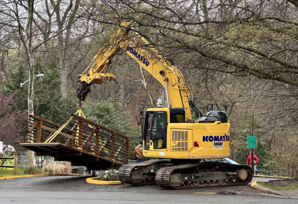
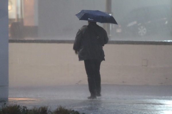
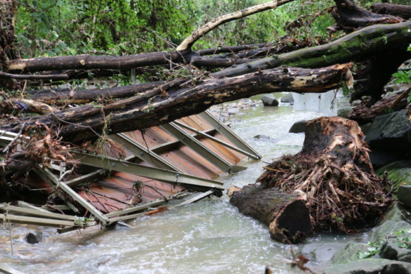
(Updated at 9:30 a.m.) Arlington and much of the D.C. area will be under a Flash Flood Watch on Christmas Eve.
A strong storm is expected to sweep through the area tomorrow afternoon and evening, bringing heavy rain and gusty wind. There may also be a few snowflakes near the end, as temperatures plummet, but no accumulation is expected locally.
More on the flooding potential, from the National Weather Service, is below.
…FLASH FLOOD WATCH NOW IN EFFECT FROM THURSDAY AFTERNOON THROUGH LATE THURSDAY NIGHT…
* ONE AND HALF TO TWO AND HALF INCHES OF RAIN ARE EXPECTED THURSDAY AFTERNOON AND THURSDAY NIGHT. THIS IS EXPECTED TO RESULT IN FLASH FLOODING OF SMALL STREAMS AND CREEKS AND POSSIBLE RIVER FLOODING.
A strong cold front will push through the region on Christmas Eve. See the graphic below for more details on the weather threats for this system. pic.twitter.com/kM2ZSYZTHu
— NWS Baltimore-Washington (@NWS_BaltWash) December 23, 2020
A powerful and large scale storm will progress from the Central to Eastern U.S. over the next few days. A variety of hazards are expected and will impact millions. All the colors on the map look like Holiday lights or a Christmas tree! pic.twitter.com/FbMNZeylM5
— National Weather Service (@NWS) December 23, 2020
A powerful cold front will bring a variety of impacts to the region today and tonight. Heavy rain, thunderstorms, and gusty winds are expected. Flash and river flooding may develop in low lying areas. Some of the rain could change to snow as arctic air moves in later tonight.
— NWS Baltimore-Washington (@NWS_BaltWash) December 24, 2020
A number of crashes have been reported around Arlington as snow and sleet cause slick conditions on local roads.
Arlington Transit has suspended at least one route, and reported major delays on others, due to the conditions. VDOT, meanwhile, is calling for people to avoid driving until conditions improve.
“VDOT asks that drivers continue to avoid nonessential travel in Northern Virginia during rush hour and overnight, as weather transitions between snow, sleet, freezing rain and rain,” the agency said around 1:30 p.m. “Crews will be working around the clock to plow snow, treat for icy conditions, remove downed trees and monitor for flooding.”
Arlington and VDOT crews are continuing to treat local roads, with county crews primarily using salt and VDOT using plows and salt. The county’s hills have proven particularly problematic, with at least one dangerous stretch — on Carlin Springs Road around Route 50 — partially closed by police, per scanner traffic.
Steady snow started the transition to sleet in Arlington around 1 p.m. The sleet is expected to become rain later today, before perhaps transitioning back to snow. Both a Winter Weather Advisory and a Flood Watch are in effect this evening, with 1-2 inches of rain expected to fall.
The National Weather Service is reporting snow accumulation of 0.5 to 1 inch in Arlington, as of 1:30 p.m., though it may be higher or lower in parts of the county.
More via social media:
County crews continue to use salt along primary routes and trouble spots. Treatment is generally weakened by rain at or near freezing. Exercise extreme caution when attempting to drive during a winter storm. #ArlWX https://t.co/JnvPU3bK6U https://t.co/1YeaJ5VJ9j
— Arlington Department of Environmental Services (@ArlingtonDES) December 16, 2020
Very active day today and tonight across our region. Depending on your location, you could see flooding, ice or heavy snow. pic.twitter.com/jLOzZBFpA7
— NWS Baltimore-Washington (@NWS_BaltWash) December 16, 2020
Measured 1.5 inches on the dot in Arlington before mixing to sleet/ice pellets @capitalweather @ARLnowDOTcom @WTOP pic.twitter.com/hnoQD6gy94
— Xavier (@xavierdomenico) December 16, 2020
Here's the earlier crash on I-395S express lanes before Eads (still blocking left side). That's @ArlingtonVaFD responding across the Potomac River from Southwest after making the round-trip into DC (the only access). @wtop @wtoptraffic @ARLnowDOTcom @VaDOTNOVA #traffic #Arlington pic.twitter.com/b9YBG4A720
— Dave Statter (@STATter911) December 16, 2020
It's a winter wonderland in Arlington!
We're closing at 2 pm today and delaying opening tomorrow until 10 am. If you're out and about, Saints, be safe and enjoy the snowfall ❄️☃️ pic.twitter.com/6V2tGK7Qhk
— Marymount University (@marymountu) December 16, 2020
Arlington Under Flood Watch — In addition to the Winter Weather Advisory that is in effect today for snow and ice, Arlington is also under a Flood Watch from 4 p.m. today and 7 a.m. Thursday. [Twitter]
Return-to-School Update — “Specific details and dates for future in-person learning transitions for students in Level 2 and Level 3 will be communicated to staff and families in early January. We continue to evaluate all metrics, and to focus on effective mitigation strategies to ensure the health and safety of staff and students.” [Arlington Public Schools]
Volunteers Needed for Bridge Work — “We need three more volunteers this Thursday to replace some rotting boards on Trollheim bridge. This event is a crucial step on the path to applying a non-slip treatment.” [Twitter]
Beyer Hails Buttigieg Nomination — Rep. Don Beyer (D-Va.) is hailing Pete Buttigieg’s reported nomination as Secretary of Transportation, calling it “barrier-breaking.” Buttigieg, while running for the Democratic presidential nomination, held a large campaign event in Arlington. [Press Release]
Nearby: Burglaries at Eden Center — “Multiple businesses were broken into at the Eden Center between 0200-0300 hours. Police and Detectives are on scene and business owners have been notified.” [Twitter]
(Updated at 2:30 p.m.) A project that could help the Westover area with its flooding problem is on the Arlington County Board agenda this weekend.
The Board on Saturday is slated to consider an agreement with Arlington Public Schools to build a stormwater detention vault under the athletic fields of the Reed Elementary School site in Westover.
The project is part of the county’s Flood Resilient Arlington stormwater strategy, which was created in response to significant floods that affected the Westover neighborhood in July 2019. The project is not expected to impact the planned opening of the new school, at 1644 N. McKinley Road, in August 2021.
County Board Chair Libby Garvey said that the project maximizes public land for the benefit of the community.
“The Westover Commercial District is a vital component of the economic, cultural and social core of the neighborhood, and it has suffered repeated flooding losses from increasingly volatile storms,” Garvey said in a statement. “This type of investment is part of a larger effort to achieve a Flood Resilient Arlington in a time of climate change. It will help prevent further devastation and enhance public safety when major rain events occur.”
The school is located in the Torreyson Run watershed, which is one of five Arlington watersheds singled out for improvements.
The project includes designing and building a large underground vault that will “form a cornerstone to a watershed-scale solution in the Torreyson Run watershed,” according to Arlington County.
The work will be broken up into two phases.
“Phase 1 of the project consists of new underground pipe and junction fixtures and is funded by the County and will cost $1.54M,” the county said in a press release. “Phase 2 includes the stormwater detention structure itself and is still under design. Both phase 1 and phase 2 are specifically being designed and scheduled to not impact school opening or operations.”
“The preliminary cost estimate for both phases is between $14.1M – $16.0M for design and construction,” the press release adds. “The length of construction will be determined during the design process.”
Arlington voters approved a $50.4 million stormwater bond last month, which will be used to pay for the second phase.
APS Superintendent Francisco Durán told Arlington County Manager Mark Schwartz in a letter that time is of the essence in approving the agreement to reimburse APS for the project upon completion.
“In order for the work of Phase 1 to be completed in time for the school to open as scheduled, this funding agreement is required promptly,” Durán wrote. “Our APS team, APS consultants and County staff have been working diligently to find the best way to achieve the County’s stormwater storage goals and open the new school on schedule.”
The County is working with APS on a Memorandum of Agreement for the school system’s construction contractor, and plans a public engagement effort with impacted communities about the design of the vault early next year.
Image via APS
Benjamin Banneker Park could open sometime before Christmas, about one year after work started and a few months behind schedule.
“We just have a few final items that we are working on,” said Arlington County Parks and Recreation spokeswoman Susan Kalish in an email. “When the park opens, you’ll find a bigger park.”
The new park is 1.8 acres larger, the W&OD and Four Mile Run trails are four feet wider, and the park’s amenities have been upgraded, she said. The $2.5 million project was given the green light in September 2019. Work started in December 2019 and was originally slated to finish in the third quarter of 2020, according to the project page.
“Due to COVID-19, the manufacture and shipping of the play equipment was delayed, necessitating the projected opening of the park to fourth quarter 2020,” said Erik Beach, a Parks and Recreation staff member, in an email.
The playground for children ages 2 to 12 got new equipment, including an obstacle balance course, rock climbing, and “soaring play towers with sky-high slides,” Kalish said.
The athletic field, meanwhile, has been expanded to the west to allow parts of the turf to rest while other parts are used, she said. Spectators will also find updated seating.
The parking lot was resurfaced and striped to improve connections between amenities and to make the dog park, fields and trail more accessible for people with disabilities. The two widened trails include a new pathway configuration around the playground, she said.
Upgrades to the picnic area include new seatings and furnishings, canopy trees and native plantings, and the dog park has new entrances and structures for dogs to explore.
While work has been ongoing, pedestrians and bicyclists using the W&OD trail had to take a detour to the busy intersection of N. Sycamore Street and 19th Street N.
After recent heavy rains, some residents have noted that part of the park tends to flood.
“Like most County parks, Benjamin Banneker Park is predominantly in a floodplain and there will always be lingering moisture due to the geographical nature of its location,” Kalish said.
But Beach said some of the drainage issues people saw during construction have been addressed as work finishes.
“Stormwater management and mitigation measures to treat pollutants include permeable pavement at the walkways and bench seating areas in the playground and a stormwater facility to treat runoff in the parking lot,” Kalish said.
These measures meet the state stormwater management requirements, and the site is graded and designed for water to flow towards Four Mile Run, she said.
Kalish said the department is still fixing a separate drainage issue in the playground’s sand pit, so the sand pit will not be available “for a bit” after the park opens.
“Once we have everything completed the park should run as smoothly as any park that in a floodplain,” she said.
Other mitigating efforts Kalish listed included planting more plant beds around the dog park, field and playground, and adding more than 600 sapling trees. A natural safety surface was installed in half of the playground area for better drainage.
“The County rejected some small areas of the safety surfacing installation, which has since been corrected,” Beach said.
Update at 11:05 p.m. — A Flood Warning has now been issued for Arlington.
1057 PM EST WED NOV 11 2020
THE NATIONAL WEATHER SERVICE IN STERLING VIRGINIA HAS ISSUED A
* FLOOD WARNING…
* UNTIL 500 AM EST THURSDAY.
* AT 1057 PM EST, DOPPLER RADAR INDICATED HEAVY RAIN. FLOODING IS ONGOING OR EXPECTED TO BEGIN SHORTLY IN THE WARNED AREA. UP TO AN OF RAIN HAS FALLEN THIS EVENING.
ADDITIONAL RAINFALL AMOUNTS OF 1 TO 2 INCHES ARE POSSIBLE IN THE WARNED AREA.
PRECAUTIONARY/PREPAREDNESS ACTIONS…
A FLOOD WARNING MEANS THAT FLOODING IS IMMINENT OR OCCURRING. ALL INTERESTED PARTIES SHOULD TAKE NECESSARY PRECAUTIONS IMMEDIATELY.
TURN AROUND, DON’T DROWN WHEN ENCOUNTERING FLOODED ROADS. MOST FLOOD DEATHS OCCUR IN VEHICLES.
BE ESPECIALLY CAUTIOUS AT NIGHT WHEN IT IS HARDER TO RECOGNIZE THE DANGERS OF FLOODING.
11:10pm – Sustained moderate to heavy rain continues to move across the area. Multiple flood warnings have been issued and more are possible. Use extreme caution if traveling tonight, and remain aware if you are in a flood prone area. More: https://t.co/5RyZgpeTAT pic.twitter.com/82poVvgoGw
— NWS Baltimore-Washington (@NWS_BaltWash) November 12, 2020
Earlier: Arlington, D.C. and other surrounding areas will be under a Flash Flood Watch tonight through Thursday morning.
Forecasters say heavy rain and even some thunderstorms are likely to roll through tonight, bringing the possibility of flash flooding. Some 2-4 inches of rain are expected.
More from the National Weather Service:
…FLASH FLOOD WATCH IN EFFECT FROM 9 PM EST THIS EVENING THROUGH THURSDAY MORNING…
THE NATIONAL WEATHER SERVICE IN STERLING VIRGINIA HAS ISSUED A
* FLASH FLOOD WATCH…
* FROM 9 PM EST THIS EVENING THROUGH THURSDAY MORNING
* SEVERAL ROUNDS OF MODERATE TO HEAVY RAINFALL, WITH A FEW EMBEDDED THUNDERSTORMS POSSIBLE, ARE EXPECTED TO PERSIST THROUGH THURSDAY MORNING. THE FIRST ROUND IS ONGOING, WITH A LULL EXPECTED LATER THIS AFTERNOON. THE SECOND ROUND COMES THIS EVENING THROUGH TONIGHT, WITH MORE MODERATE TO HEAVY RAINFALL EXPECTED. STORM TOTAL RAINFALL OF 2-4 INCHES IS EXPECTED THROUGH THURSDAY. WHERE HEAVIER ELEMENTS PERSIST, WE COULD SEE LOCALLY HIGHER AMOUNTS. THIS COULD RESULT IN LOCALIZED INSTANCES OF FLASH FLOODING.
PRECAUTIONARY/PREPAREDNESS ACTIONS…
A FLASH FLOOD WATCH MEANS THAT CONDITIONS MAY DEVELOP THAT LEAD TO FLASH FLOODING. FLASH FLOODING IS A VERY DANGEROUS SITUATION. YOU SHOULD MONITOR LATER FORECASTS AND BE PREPARED TO TAKE ACTION SHOULD FLASH FLOOD WARNINGS BE ISSUED.
Areas of moderate to heavy rain beginning to overspread much of the region. A lull expected after this first round later today, then more moderate to heavy rain moves in this evening/tonight. #DCwx #MDwx #VAwx #WVwx pic.twitter.com/jG8RwPQ4i9
— NWS Baltimore-Washington (@NWS_BaltWash) November 11, 2020
A Flash Flood Watch is in effect for tonight through late Thursday morning. The first segment will be across most of central VA before expanding to the second segment in northern VA, DC metro and southern MD late tonight as these heavier bands progress through our area. pic.twitter.com/ZfEqtkSogW
— NWS Baltimore-Washington (@NWS_BaltWash) November 11, 2020
Update at 4 p.m. — The Flood Warning has now been cancelled.
Earlier: As what remains of Hurricane Zeta drenches the region, Arlington County is now under a Flood Warning, meaning flooding is currently happening or is imminent.
“Observations show we’re crossing the 1.5″ rain total threshold throughout much of the urban corridor,” the National Weather Service said just before noon. “Flooding is going to be slow to develop but we should see increasing reports of it this afternoon.”
Flooding has already been reported west of Arlington in Fairfax County, along Wolftrap Creek and Accotink Creek. The warning is in effect until 5:30 p.m.
In addition to heavy rain, strong winds are expected between roughly 5-8 p.m. this evening as the center of the storm passes the region.
More on the potential for flooding, from the National Weather Service:
BULLETIN – IMMEDIATE BROADCAST REQUESTED
FLOOD WARNING
NATIONAL WEATHER SERVICE BALTIMORE MD/WASHINGTON DC
1130 AM EDT THU OCT 29 2020THE NATIONAL WEATHER SERVICE IN STERLING VIRGINIA HAS ISSUED A
* FLOOD WARNING FOR… THE DISTRICT OF COLUMBIA… NORTHWESTERN ANNE ARUNDEL COUNTY IN CENTRAL MARYLAND… EASTERN HOWARD COUNTY IN CENTRAL MARYLAND… SOUTHEASTERN MONTGOMERY COUNTY IN CENTRAL MARYLAND… NORTHERN PRINCE GEORGES COUNTY IN CENTRAL MARYLAND… BALTIMORE COUNTY IN NORTHERN MARYLAND… BALTIMORE CITY IN NORTHERN MARYLAND… ARLINGTON COUNTY IN NORTHERN VIRGINIA… NORTHEASTERN FAIRFAX COUNTY IN NORTHERN VIRGINIA… THE CITY OF ALEXANDRIA IN NORTHERN VIRGINIA… THE CITY OF FALLS CHURCH IN NORTHERN VIRGINIA…
* UNTIL 530 PM EDT.
* AT 1130 AM EDT, DOPPLER RADAR INDICATED HEAVY RAIN. FLOODING IS ONGOING OR EXPECTED TO BEGIN SHORTLY IN THE WARNED AREA. BETWEEN 0.5 AND 1.5 INCHES OF RAIN HAVE FALLEN.
ADDITIONAL RAINFALL AMOUNTS OF 1 TO 3 INCHES ARE POSSIBLE IN THE WARNED AREA THROUGHOUT THE DAY.
PRECAUTIONARY/PREPAREDNESS ACTIONS…
A FLOOD WARNING MEANS THAT FLOODING IS IMMINENT OR OCCURRING. ALL INTERESTED PARTIES SHOULD TAKE NECESSARY PRECAUTIONS IMMEDIATELY.
TURN AROUND, DON’T DROWN WHEN ENCOUNTERING FLOODED ROADS. MOST FLOOD DEATHS OCCUR IN VEHICLES.
Image via National Weather Service
Update at 12:15 p.m. — A Flood Warning has now been issued.
Earlier: Arlington and much of the region is under a Flood Watch as the remnants of Hurricane Zeta track across the South and towards the D.C. area.
Rain is expected to begin overnight and continue throughout Thursday. Around 2-3 inches of rain are expected to fall.
Zeta will also bring windy conditions, with winds of up to 30-40 mph during the peak of the storm, later in the day on Thursday. That raises the possibility of downed trees and power lines.
Zeta made landfall late Wednesday afternoon as a Category 2 hurricane, stronger than initially expected. As of 9 p.m. tonight the storm was still packing hurricane-force winds as it tears through Gulfport, Biloxi and other areas along the Gulf of Mexico. It’s expected to bring strong winds and heavy rain to Birmingham, Atlanta, Asheville, Roanoke and Richmond before reaching our region.
4 PM CDT Wednesday, October 28 Hurricane #Zeta Key Messages. Zeta is making landfall near Cocodrie, Louisiana. Hurricane conditions and life-threatening storm surge imminent along portions of the southeastern Louisiana and Mississippi coasts. https://t.co/bDPuXcHB38 pic.twitter.com/hjjl3RH0vP
— National Hurricane Center (@NHC_Atlantic) October 28, 2020
More on the Flood Watch from the National Weather Service:
THE NATIONAL WEATHER SERVICE IN STERLING VIRGINIA HAS ISSUED A
* FLOOD WATCH FOR PORTIONS OF VIRGINIA AND EASTERN WEST VIRGINIA, INCLUDING THE FOLLOWING AREAS: IN VIRGINIA, ALBEMARLE, AUGUSTA, CENTRAL VIRGINIA BLUE RIDGE, CLARKE, EASTERN HIGHLAND, GREENE, MADISON, NELSON, NORTHERN VIRGINIA BLUE RIDGE, PAGE, RAPPAHANNOCK, ROCKINGHAM, SHENANDOAH, WARREN AND WESTERN HIGHLAND. IN EASTERN WEST VIRGINIA, EASTERN PENDLETON AND WESTERN PENDLETON.
* FROM LATE TONIGHT THROUGH THURSDAY AFTERNOON
* HEAVY RAINFALL FROM ZETA COULD LEAD TO SOME FLOODING OF SMALL STREAMS, CREEKS, AND URBAN AREAS. RAIN AMOUNTS OF 2 TO 3 INCHES ARE EXPECTED WITH LOCALLY HIGHER AMOUNTS POSSIBLE.
* SCATTERED INCIDENTS OF FLOODING DUE TO HEAVY RAIN ARE POSSIBLE. CLOGGED DRAINS DUE TO LEAF DEBRIS MAY CAUSE ADDITIONAL FLOODING CONCERNS.
PRECAUTIONARY/PREPAREDNESS ACTIONS…
DO NOT ENTER OR CROSS FLOWING WATER OR WATER OF UNKNOWN DEPTH.
STAY AWAY OR BE SWEPT AWAY. RIVER BANKS AND CULVERTS CAN BECOME UNSTABLE AND UNSAFE.
A FLOOD WATCH MEANS THERE IS A POTENTIAL FOR FLOODING BASED ON CURRENT FORECASTS. YOU SHOULD MONITOR LATER FORECASTS AND BE ALERT FOR POSSIBLE FLOOD WARNINGS. THOSE LIVING IN AREAS PRONE TO FLOODING SHOULD BE PREPARED TO TAKE ACTION SHOULD FLOODING DEVELOP.
Here is an overview of what to expect from the remnants of Zeta. A widespread 2 to 3 inches of rainfall are likely with a Flood Watch in effect from 4 AM through 10 PM Thursday. Minor instances of flooding will be possible as this system moves through. #MDwx #VAwx #WVwx #DCwx pic.twitter.com/S0Dk0HESzy
— NWS Baltimore-Washington (@NWS_BaltWash) October 29, 2020
(Updated at 5:30 p.m.) Flooding has been reported in parts of Arlington, Alexandria, D.C. and Montgomery County after a period of very heavy rain.
In Arlington, the deluge left high water on Route 110, prompting police to close the highway between Rosslyn and the Pentagon. Standing water was also reported on Columbia Pike near the Pentagon.
If you are NB on Rt 1 in Crystal City you will be forced to exit onto NB I-395 due to the usual Rt 110 flooding. Both @ArlingtonVaFD & @ArlingtonVaPD responded to the flooding. Heavy rain has stopped. @ARLnowDOTcom @WTOPtraffic pic.twitter.com/apm5NwcubH
— Dave Statter (@STATter911) September 10, 2020
Flooding was also reported on the GW Parkway, near the airport.
⚠️ Due to reports of flooding on the George Washington Memorial Parkway near the airport Thursday afternoon, use Route 1 from Crystal City for airport access and expect roadway delays in the area
— Reagan Airport (@Reagan_Airport) September 10, 2020
As of 5 p.m., both Route 110 and the GW Parkway were reported to be back open.
The Flash Flood Warning was issued earlier this afternoon, and was in effect until 4:30 p.m. More from the National Weather Service:
140 PM EDT THU SEP 10 2020
…FLASH FLOOD WARNING REMAINS IN EFFECT UNTIL 430 PM EDT THIS AFTERNOON FOR SOUTHEASTERN MONTGOMERY, NORTHWESTERN PRINCE GEORGES, SOUTHEASTERN ARLINGTON AND SOUTHEASTERN FAIRFAX COUNTIES AND THE DISTRICT OF COLUMBIA AND THE CITY OF ALEXANDRIA…
AT 140 PM EDT, DOPPLER RADAR INDICATED THUNDERSTORMS PRODUCING HEAVY RAIN ACROSS THE WARNED AREA. BETWEEN 1 AND 2 INCHES OF RAIN HAVE FALLEN. FLASH FLOODING IS ONGOING OR EXPECTED TO BEGIN SHORTLY.
HAZARD…LIFE THREATENING FLASH FLOODING. THUNDERSTORMS PRODUCING FLASH FLOODING.
SOURCE…DOPPLER RADAR.
IMPACT…LIFE THREATENING FLASH FLOODING OF CREEKS AND STREAMS, URBAN AREAS, HIGHWAYS, STREETS AND UNDERPASSES.
ADDITIONAL RAINFALL AMOUNTS OF 1 TO 2 INCHES ARE POSSIBLE IN THE WARNED AREA.
PRECAUTIONARY/PREPAREDNESS ACTIONS…
TURN AROUND, DON’T DROWN WHEN ENCOUNTERING FLOODED ROADS. MOST FLOOD DEATHS OCCUR IN VEHICLES.
Flash Flood Warning including Washington DC, Arlington VA, Alexandria VA until 4:30 PM EDT pic.twitter.com/mV92zVtRnX
— NWS Baltimore-Washington (@NWS_BaltWash) September 10, 2020
A Flash Flood Watch has been issued for Arlington, set to take effect early tomorrow morning.
The watch is in effect from 2 a.m.-8 p.m. Thursday. Forecasters say expected heavy rain could result in flash flooding.
More from the National Weather Service:
The Flash Flood Watch has been expanded and extended to include most of the DC and Baltimore metro areas from 2 am tonight until 8 pm Thursday. Visit https://t.co/MW83KHFiJb for updates. pic.twitter.com/zSjbnpOmhs
— NWS Baltimore-Washington (@NWS_BaltWash) September 9, 2020
…FLASH FLOOD WATCH IN EFFECT FROM 2 AM EDT THURSDAY THROUGH THURSDAY EVENING…
THE NATIONAL WEATHER SERVICE IN STERLING VIRGINIA HAS EXPANDED THE
* FLASH FLOOD WATCH TO INCLUDE PORTIONS OF DC… MARYLAND AND NORTHERN VIRGINIA, INCLUDING THE FOLLOWING AREAS: IN DC, DISTRICT OF COLUMBIA. IN MARYLAND, CENTRAL AND SOUTHEAST HOWARD, CENTRAL AND SOUTHEAST MONTGOMERY, SOUTHEAST HARFORD AND SOUTHERN BALTIMORE. IN NORTHERN VIRGINIA, ARLINGTON/FALLS CHURCH/ALEXANDRIA, FAIRFAX AND PRINCE WILLIAM/MANASSAS/MANASSAS PARK.
* FROM 2 AM EDT THURSDAY THROUGH THURSDAY EVENING
* NUMEROUS SHOWERS AND A FEW THUNDERSTORMS WILL CONTINUE TO DEVELOP ACROSS THE AREA, WITH LOCALLY HEAVY RAIN MOST LIKELY FROM LATE TONIGHT THROUGH THURSDAY AFTERNOON. AVERAGE RAINFALL AMOUNTS OF ONE TO TWO INCHES ARE EXPECTED, WITH ISOLATED HIGHER AMOUNTS POSSIBLE.
* HEAVY RAINFALL MAY RESULT IN RAPID RISES OF WATER IN SMALL CREEKS AND STREAMS, AS WELL AS IN URBAN AND POOR DRAINAGE AREAS.
PRECAUTIONARY/PREPAREDNESS ACTIONS…
A FLASH FLOOD WATCH MEANS THAT CONDITIONS MAY DEVELOP THAT LEAD TO FLASH FLOODING. FLASH FLOODING IS A VERY DANGEROUS SITUATION. YOU SHOULD MONITOR LATER FORECASTS AND BE PREPARED TO TAKE ACTION SHOULD FLASH FLOOD WARNINGS BE ISSUED.