Update at 5:55 p.m. — Arlington and much of the D.C. and Baltimore region is now under a Severe Thunderstorm Watch.
A severe thunderstorm watch has been issued for parts of DC, MD, VA until 11 PM EDT pic.twitter.com/wRkTqvrADp

Update at 5:55 p.m. — Arlington and much of the D.C. and Baltimore region is now under a Severe Thunderstorm Watch.
A severe thunderstorm watch has been issued for parts of DC, MD, VA until 11 PM EDT pic.twitter.com/wRkTqvrADp

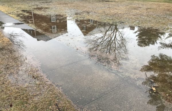
Flooding Closes Roads, Prompts Warning — Updated at 8:45 a.m. — Many Arlington residents may be bleary-eyed this morning after being woken up twice overnight: once by thunder, and another time by a Flash Flood Warning that sounded on many phones. Heavy rain caused flooding that prompted the temporary closure of I-66 in Arlington and the HOV lanes of I-395 just before the 14th Street Bridge. A Flood Warning remains in effect until 11:45 a.m. as additional rain is expected this morning. [Twitter, Twitter, Twitter]
Crystal City ‘Makes Parking Garages Cool Again’ — Some national press for the Crosshairs Garage Races in Crystal City: “Unbeknownst to the few at street level, there’s a crowd gathering in a parking garage below an unremarkable office building. Inside, giant speakers blast rock music. Cow bells ring. There’s whooping and hollering, there’s pie and beer–and there are bikes everywhere.” [Citylab]

(Updated at 5:15 p.m.) A Winter Storm Watch has been issued for the D.C. area as Arlington County crews prepare for several inches of snow.
The storm is expected to start as rain tomorrow, the first day of spring, before transitioning to snow. The National Weather Service noted on its Twitter page that there is “lots of uncertainty” in terms of the type of precipitation.
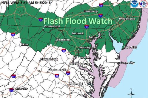
Arlington and parts of the D.C. area are under a Flood Watch starting 7 p.m. Saturday.
The National Weather Service says repeated bouts of moderate-to-heavy rain may cause flooding along streams and low-lying areas.

Nate Remnants Pushing Out — It has been a rainy and windy morning thanks to the remnants of what was once Hurricane Nate. The heaviest of the rain is over but it is expected to remain windy and humid during the day today, with a gale warning in effect until 6 p.m. for those on the water. [Twitter, Weather Channel]
Voter Registration Up This Cycle — Arlington County has processed twice the number of voter registration transactions between Labor Day and Oct. 6 this year as it did during the same period four years ago, according to elections chief Linda Lindberg. That suggests greater interest in this year’s statewide races for governor, lieutenant governor and attorney general, though County Board and School Board races are also on the ballot. [InsideNova]

Forecasters say Arlington could break its rainless streak next week, depending on what happens with Tropical Depression 16, which is expected to turn into Tropical Storm Nate.
The storm has the potential to intensify rapidly and could strike the Gulf Coast as a strong tropical storm or Category 1 hurricane this weekend. The storm is expected to make its way north just as a cold front is pushing into the East Coast.

September Is National Preparedness Month — Arlington is marking National Preparedness month by reminding residents to sign up for emergency alerts, create an emergency plan and maintain disaster supplies. [Arlington County]
Crash on Columbia Pike — A car veered off the side of Columbia Pike and knocked a light pole over on the sidewalk in front of Lost Dog Cafe. No serious injuries were reported. The aftermath of the crash was caught on video. [Facebook]

Reminder: Dogs Not Allowed Off-Leash in Arlington — “In the last year, the Animal Welfare League of Arlington received 260 reports of dogs running at large and more than 120 sightings of strays. Being off-leash in Arlington is only allowed on private property and in designated dog parks.” [Arlington County]
AAA: Gas Prices Up Due to Harvey — The ongoing disaster along the Gulf in Texas is causing gas prices to rise in the D.C. area, according to AAA Mid-Atlantic. [Alexandria News]
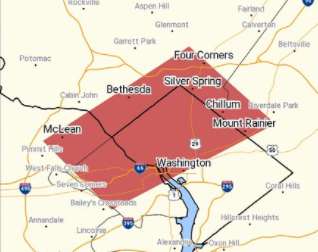
Flash Flood Warning including Washington DC, Arlington VA, Silver Spring MD until 2:15 PM EDT pic.twitter.com/0zWk6n1sQ1
— NWS Baltimore-Washington (@NWS_BaltWash) August 15, 2017

Update at 4:25 p.m. — The Flash Flood Watch has been cancelled.
415pm: Flash Flood Watch CANCELLED. Heavy rain threat has ended.

Today’s heavy rain has turned Four Mile Run into a raging torrent of murky water.
A Columbia Pike resident posted videos of the overflowing stream on Twitter this afternoon (Friday). The video was taken near S. George Mason Drive.

Updated at 6:25 p.m. — The National Weather Service is warning of a continued threat of very heavy rainfall and flooding tonight.
HIGH RISK of excessive rainfall: Dangerous situation unfolding this evening/tonight with continued heavy rain and increasing flash flooding. pic.twitter.com/OENHSM5b3J