Update at 6:20 p.m. — The watches have been canceled.
Update at 1:25 p.m. — A Severe Thunderstorm Watch has also been issued for Arlington, from 1:15-9 p.m.


Update at 6:20 p.m. — The watches have been canceled.
Update at 1:25 p.m. — A Severe Thunderstorm Watch has also been issued for Arlington, from 1:15-9 p.m.
Update at 10:40 p.m. — There are still 664 Dominion customers without power across various parts of Arlington, according to the power company.
Update at 6:05 p.m. — About 700 Dominion customers are reported to be without power in Arlington, mostly in residential north Arlington, following the storms. Nearly 35,000 are reported to be without power in Fairfax County, including in the McLean area.

(Updated at 1:45 p.m.) As Arlington continues to recover from Monday’s flash flooding, another Flash Flood Watch has been issued.
The National Weather Service says more heavy rain and flooding is possible today, in addition to storms and damaging winds. The watch takes effect starting at 2 p.m.

It’s shaping up to be a wet Sunday night.
Arlington County and surrounding areas are under a Flash Flood Watch starting at 6 p.m. Slow-moving rainstorms are expected to drop copious amounts of precipitation on much of the region, particularly to the west of D.C.

Arlington is again under a Severe Thunderstorm Watch tonight.
The watch, which goes until 10 p.m., is in addition to a separate Flash Flood Watch through 11 p.m.

Columbia Pike Flooding — Columbia Pike flooded near S. Greenbrier Street during last night’s storms. Drivers could be seen driving through standing water as high as the tops of car tires. [Twitter]
Another Flash Flood Watch — Arlington is again under a Flash Flood Watch from 2-11 p.m. today, as slow-moving storms may produce torrential, flooding rainfalls. [Weather.gov, Twitter]

Update at 4:25 p.m. — A Severe Thunderstorm Watch has been issued for Arlington through 11 p.m.
A severe thunderstorm watch has been issued for parts of DE, DC, MD, NJ, PA, VA until 11 PM EDT pic.twitter.com/VN2Fyzlgel

Arlington County and the entire region is under a Severe Thunderstorm Watch Sunday afternoon and evening.
Storms packing damaging winds and large hail are heading toward the D.C. area from the west, with a cold front that’s expected to lower temperatures and humidity levels.

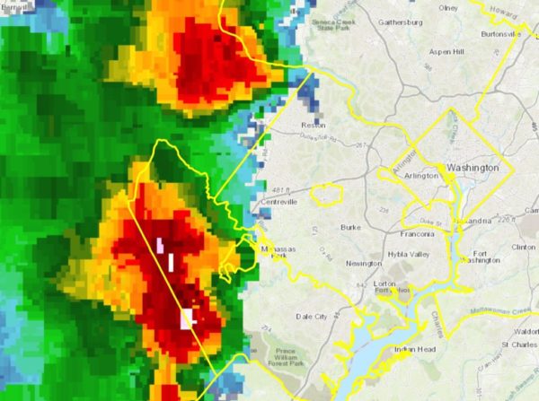
Update at 3:10 p.m. — Arlington is now under a Severe Thunderstorm Warning. From the National Weather Service:
THE NATIONAL WEATHER SERVICE IN STERLING VIRGINIA HAS ISSUED A

Update at 8:40 p.m. — Closures along Lee Highway and N. Glebe Road, among others, are expected to remain in place into the morning rush hour, according to Arlington Alert.
INCIDENT: Weather Related Closures
LOCATION: County-Wide
IMPACT: Closures expected into the morning commute: Lee HW btwn John Marshall Dr & Nottingham, N Barton btwn 10th & 12th St N, 11th St N btwn Cleveland & 2300 blk, N Glebe Rd btwn 50 & Henderson pic.twitter.com/66GpWKVIub

Arlington County and much of the D.C. region is now under a Flash Flood Watch.
The watch is in effect until 10 a.m. Sunday. Forecasters say multiple rounds of heavy rain and storms could produce flash flooding.

Update at 2:50 p.m. — The Severe Thunderstorm Warning has been cancelled by the National Weather Service.
Update at 2:30 p.m. — A Severe Thunderstorm Warning has been issued for Arlington.