A nearly 60-year-old bridge over N. Glebe Road is slated for replacement.
The circa-1964 Old Glebe Road bridge, which spans the north-south artery just before the steep hill down to Chain Bridge, would be too costly to repair, VDOT says. The state transportation agency is instead planning a $15 million project to replace it.
About 7,000 vehicles per day use the bridge, VDOT says. A virtual public meeting is planned this Wednesday at 7 p.m. to discuss the project.
VDOT’s current timeline calls for a public meeting late next year to discuss the design of the new bridge, followed by construction starting in mid-2027.
More, below, from a VDOT email.
The Virginia Department of Transportation will hold a virtual public information meeting Wednesday, Oct. 18 on the planned replacement of the North Old Glebe Road bridge over North Glebe Road (Route 120). The bridge, which averages 7,000 vehicles a day, was built in 1964.
A new bridge will be constructed due to the estimated rehabilitation cost of the existing bridge exceeding 65% of the estimated cost to replace the bridge.
The new bridge will feature a wider sidewalk on the eastern side and an additional sidewalk on the western side.
Get Involved
In lieu of an in-person meeting, VDOT invites residents and travelers to learn more, participate in the virtual meeting and give feedback in the following ways through Nov. 1:
- Attend the Oct. 18 online meeting. Register for the meeting or to participate without registering in listen-only mode, call 844-992-4726 (use access code 2484-673-7292 and password 1234). The project team will make a short presentation beginning at 7 p.m. and answer questions after the presentation. In case an alternate date is needed, the meeting will be held Nov. 1.
- Provide comments via the online comment form or by email to [email protected].
- Mail comments to Ms. Dipali Patel, P.E., Virginia Department of Transportation, 4975 Alliance Drive, Fairfax, VA 22030.
Meeting materials and the presentation will be available online at virginiadot.org/OldGlebe, including the recorded presentation after the meeting.
A severely eroded ditch along N. Glebe Road near Chain Bridge is set for some restoration work.
The Arlington County Board this weekend is expected to approve a contract of up to $1.2 million. At least part of that will be reimbursed by VDOT, which maintains the road.
The work follows a major water main break in November 2019, which damaged both the road and the roadside ditch.
More from a county staff report:
This project includes the restoration of the existing ditch located along the south side of North Glebe Road (Route 120) that was severely eroded following the 36” transmission water main break in November 2019. Arlington County Department of Environmental Services (DES,) Virginia Department of Transportation (VDOT) and the National Park Service (NPS) have partnered to implement this improvement and restoration project. The restoration includes 500 feet of the ditch downstream of the water main break and stabilization improvements for 1,000 feet of the ditch upstream of the break to be improved with Class II riprap, as well as new guardrail installation to replace a previous guardrail and temporary jersey wall and restoration of the Potomac Heritage National Scenic Trail, which crosses this ditch in the downstream segment underneath George Washington Memorial Parkway.
The work also includes tree removal and planting/seeding, erosion and sediment control, and all other related incidental work described and required in the contract documents. Most of the work is planned to be performed at night utilizing an overnight road closure of North Glebe Road as outlined in the VDOT approved Temporary Traffic Control Plan. VDOT is reimbursing the County for the construction costs of the improvements located upstream of the water main break.
The report goes on to note that the county hired a consultant, Wetland Studies and Solutions Inc., to develop the repair plan.
Additionally, the report says the accepted bid — from Fairfax-based Bright Construction Group — is 13% higher than an engineer’s estimate, likely owing to complications caused by the rugged terrain and the work area being on both National Park Service and VDOT property.
…it is believed that the bidders perceived more risk and challenges in these bid items, which we consider fair given the unique challenges of this project area, where the contractor will be working on an actively flowing stream channel on NPS Lands, as well as within the narrow shoulder of a two-lane undivided VDOT-owned arterial roadway, North Glebe Road (US Route 120), that carries approximately 11,000 vehicles per day. For the work on Federal Lands and in VDOT right-of-way, the contractor will have to comply with restrictive NPS and VDOT permit requirements and perform all restoration as per each agency’s specifications.
The Board is scheduled to vote on the contract during its meeting this Saturday.
For years, parts of Columbia Pike have been under construction, resulting in wider sidewalks, newly-planted trees and underground utilities, among other changes.
Now, work on the penultimate phase of the years-long Columbia Pike Multimodal Street Improvements project is slated to begin in September, according to the county. Work could begin on the final phase early next year.
Starting in September, the county will upgrade the Pike’s streetscape, enhance transit infrastructure, replace aging water and sewer mains and bury utility lines between S. Garfield Street and S. Courthouse Road.
The final segment, from S. Courthouse Road to S. Quinn Street, could begin in early 2024 and wrap up in late 2025, according to Dept. of Environmental Services spokeswoman Claudia Pors.
A contract for this phase was approved earlier this summer, the Gazette Leader reported.
Streetscape improvements to the Pike have been ongoing for nearly two decades.
The first segment was completed back in 2009, Pors said. The next two segments were completed in 2015, one by the county and the other by the Virginia Dept. of Transportation.
Concurrently, the county also created “bike boulevards” parallel to the Pike, diverting cyclists from car-heavy corridor in advance of the planned, but never built, streetcar.
Last year, the county started working on improvements between S. Wakefield Street and S. Oakland Street and S. Orme Street and S. Oak Street. The federal government is handling similar upgrades east of S. Oak Street as part of its project to realign the road to accommodate the expansion of Arlington National Cemetery.
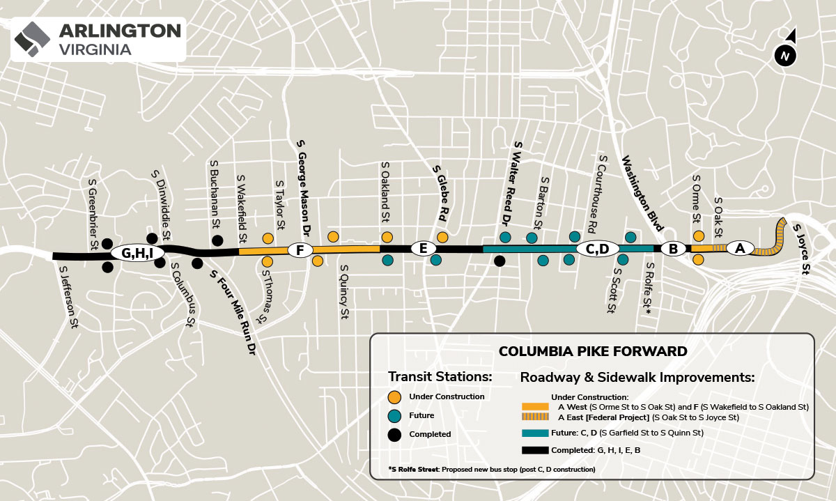
Before getting started on the S. Garfield Street to S. Courthouse Road segment, county staff will hold pop-ups and open houses in the area to inform community members of the changes, Pors said.
She added that the team has not yet come up with a final work schedule, though work will likely be less intense than the currently under construction portion of the Pike between S. Quincy Street and S. Oakland Street.
Work hours will be Monday through Friday from 7 a.m. to 6 p.m. and Saturdays from 10 a.m. to 6 p.m., according to the county website.
“Residents should expect to see and hear dust, mud, noise, debris, and temporary traffic and parking restrictions,” the website says. “In locations where parking will be prohibited during work, no parking signs will be posted.”
“These roadway changes are essential for the contractors to construct a safer and more accessible Columbia Pike in an efficient and safe manner while maintaining access to residences and businesses along the corridor,” Arlington County says on its website.
This work has previously closed lanes on other stretches of the Pike and even resulted on the occasional rogue utility pole.
Work is underway to make a 53-year-old bridge S. Abingdon Street bridge over I-395 safer and extend its overall life, per the Virginia Dept. of Transportation.
The 53-year-old bridge is located between the I-395 interchanges for King Street and Shirlington Circle in the Fairlington neighborhood. It was last rehabilitated in 1994 and is in need of attention, according to a press release from the state transportation department.
The planned repairs will use $8.4 million in federal and state funding and will wrap up in late 2024, the press release said.
Work includes rehabilitating the bridge deck, repairing deteriorating concrete, replacing all steel bearings and eliminating bridge joints, per a project overview video.
Arlington County also identified S. Abingdon Street, from 34th Street S. to Fire Station 7, for resurfacing. It is coordinating with the state on those changes, including a buffered bike lane to improve the cycling experience and narrower travel lanes to manage vehicle speeds.
Bridge deck rehabilitation work will last about 12 weeks and occur in three stages, the video says.
In the first phase, all traffic will be shifted to the east side of the bridge, with two shared bicycle and traffic lanes and one five-foot-wide sidewalk. A temporary crosswalk will be added near 36th Street S. In the second phase, all traffic will be shifted to west side of the bridge.
In the third stage, traffic will be split on both sides of the work zones and the crosswalk will be removed.
“When one sidewalk along the bridge is closed, pedestrians will be detoured to the sidewalk on the opposite side,” VDOT said in the press release. “Drivers, bicyclists and pedestrians are reminded to use caution when traveling in active work zones. Be alert to new traffic patterns and limit distractions.”
The I-395 main and express lanes may see periodic daytime and overnight lane closures, VDOT says.
“Most of the work below the bridge will be performed during nighttime operation to avoid impact to normal daytime traffic particularly peak hour traffic,” the project video says.
Transportation and streetscape upgrades are making progress on several streets in Courthouse near an under-construction apartment tower.
The work is all associated with “The Commodore,” an new apartment building at 2050 Wilson Blvd. It replaces several low-slung commercial buildings, including restaurants like Summers, that were part of what Arlington County dubbed the “Landmark Block.” Today (Tuesday), fencing around the tower was festooned with banners announcing leasing would start this fall.
Developer Greystar is redoing a handful of streets nearby as part of the community benefits package associated with the project.Arlington County delegated some street upgrade work to Greystar in early 2022, saying it would be cheaper, easier and more efficient for the company to do the work as part of the apartment construction activity.
Today, pedestrians may notice fencing around a torn-up N. Uhle Street, which separates the Courthouse Metro station and the “Landmark Block.” This street previously had street trees, lighting and parking spaces.
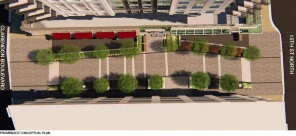
Eventually, it will become a long-envisioned pedestrian promenade leading to the Courthouse Metro station.
The block will have public seating lined with shade trees, lighting and landscaped planting beds, potentially bookended by public art.
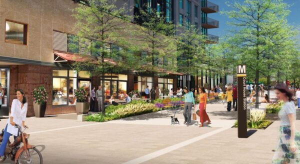
Nearby, 15th Street N. looks freshly repaved and is partly blocked off to vehicle traffic by jersey barriers, cones and caution tape. Signs along this street announce temporarily relocated bus stops.
It will become a curbless street shared by pedestrians, cyclists and drivers, featuring a “slow speed configuration” to increase the safety of users.
Clarendon Blvd, Wilson Blvd and N. Courthouse Road will get wider sidewalks, new pedestrian crossings, protected or dedicated bike lanes, widened medians and new trees and planted beds. The county parking lot entrance from 15th Street N. will be relocated, as well.
Greystar is also relocating existing and installing new traffic infrastructure, adding a “bike island” at the intersection of 15th Street N. and Clarendon Blvd and a new water main under N. Courthouse Road.
Those who want to know the latest vehicle and pedestrian traffic impacts can subscribe to a county newsletter for the area.
Two blocks away, construction is also continuing on the former Wendy’s lot, another Greystar project. The former fast food joint is being replaced with an apartment tower, ground-floor retail and a plaza at 2025 Clarendon Blvd, — as approved in March 2022. Together, the two projects realize a significant part of the county’s vision for the neighborhood.
This Wendy’s project will also result in transportation upgrades, such as bicycle amenities, new sidewalks and street trees, to Clarendon Blvd and Wilson Blvd.
Greystar declined to provide a construction update to ARLnow for this article.
The County Board is set to vote this weekend on a contract to build a long-awaited pedestrian bridge.
On Saturday, it is expected that the Arlington County Board will approve a $1.6 million contract to construct the Shirlington Road Pedestrian Bridge. The 15-foot-wide prefabricated steel bridge will run the length of Four Mile Run and parallel to the road with the purpose of providing safer bicycle and pedestrian access.
It will connect Shirlington and S. Arlington Mill Drive to Jennie Dean Park and the Green Valley neighborhood. It will also serve local users of the heavily-used Four Mile Run and W&OD trails nearby.
Work on the bridge could begin in the second half of this year if the contract is approved over the weekend, Arlington Dept. of Environmental Services spokesperson Claudia Pors told ARLnow. That would mean a completion date in mid to late 2024.
“The existing Shirlington Road vehicular bridge primarily funnels vehicles to/from I-395 and lacks safe, comprehensive accommodations for pedestrians and bicyclists traveling through this area,” the report to the Board says.
“This project will provide a key missing link in the County’s bicycle network by providing a north-south protected bicycle facility that will link up with the existing Four Mile Run Trail along South Arlington Mill Drive to the west and along Four Mile Run in the City of Alexandria to the east of the bridge,” the report adds.
The bridge has been under discussion for two decades and has been the topic of conversation among county staff and the public for years.
It will be constructed in two parts, per Pors. First, the span will be built offsite, a process that will take about nine months, while abutments will be added at S. Arlington Mill Drive and Jennie Dean Park where each end of the bridge will go. Around this time, the bridge’s walls will be built and the sidewalk and crosswalk at S. Arlington Mill Drive will be shuttered. Bike and pedestrian traffic will be detoured.
The bridge, then, will be lifted by a crane and installed.
“It’s possible that lanes on the existing bridge will close to accommodate this installation, and the public would be given notice of any detours,” Pors noted.
New street lighting on each end of the bridge will be installed as well, plus median, sidewalk and crosswalk retrofits. A new Rectangular Rapid Flashing Beacon will be installed in the median as well.
The work is set to be done by D.C.-based Milani Construction, whose $1.38 million bid (plus $277,000 in contingency costs) actually came in under the county engineer’s estimated construction cost.
Last year, work was completed on the parallel vehicle bridge on Shirlington Road. That included resurfacing, routine maintenance, widening the sidewalk by several feet on the west side of the bridge, widening curb ramps, and adding a median at the mid-block crosswalk near 27th Street S.
A number of these improvements came as a result of public feedback.
Additionally, the county is set to study the feasibility of adding another crossing at the intersection of S. Arlington Mill Drive and Shirlington Road.
“County staff have begun study efforts and anticipate reaching out to the public for input this fall,” Pors said.
The West Glebe Road bridge partially reopened yesterday, though pedestrian and bicycle traffic will have to wait to make use of the span over Four Mile Run.
The bridge had severely deteriorated, requiring partial closures over the years until the bridge was fully closed last summer.
Work then began to replace the deteriorated roadway substructure, while reusing existing piers to shorten the construction time and keep costs down, according to Arlington County.
The bridge partially reopened yesterday (Wednesday) with one lane open in each direction.
According to the county website:
As of March 8, 2023, the West Glebe Road bridge is open to motor vehicle traffic, with one lane open in each direction. Pedestrian and bike traffic will continue to detour on the temporary bridge to the east of the main bridge.
The bridge is expected to fully open in summer of 2023, after completion of work on parapets, substructure, and streetlights.
The county says the next phase of construction will see the bike lane, curb and sidewalk put into place.
The Four Mile Run Trail underpass on the north end of the bridge remains closed until reconstruction is completed.
Some breaking news on the West Glebe Bridge: pic.twitter.com/QQV38teGd2
— Justin Wilson (@justindotnet) March 9, 2023
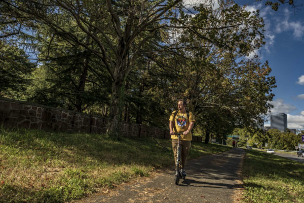
The third time could be the charm for Arlington County, which is applying for federal funding to improve cycling and walking connections around Arlington National Cemetery.
On Saturday, the Arlington County Board is scheduled to review the county’s third application for funding from the Rebuilding American Infrastructure with Sustainability and Equity (RAISE) Program.
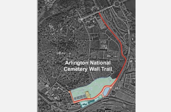
The money would partially fund the construction of a long-proposed Arlington National Cemetery (ANC) Wall Trail along Washington Blvd, which would connect Columbia Pike and the Pentagon City area with Memorial Avenue and the Arlington Memorial Bridge into D.C.
“Connectivity for bike-ped users across this part of the County is complicated by the combined barrier effects of secured federal facilities such as ANC, Joint Base Myer-Henderson Hall, and the Pentagon Reservation” and “a high-volume roadway network” comprised of Arlington Boulevard, Washington Blvd, Route 1 as it runs through Pentagon City, I-395 and the GW Parkway, the county notes in a report.
The new trail would run along the western side of Washington Blvd. An existing trail on the opposite side gets dicey near Memorial Circle for pedestrians and cyclists looking to connect to the Mt. Vernon Trail or cross into D.C.
The Federal Highway Administration is designing this multi-use trail in conjunction with the realignment of Columbia Pike. This work is being done to accommodate the 50-acre southern expansion of the ANC, which will add about 80,000 burial sites, allowing burials through the 2050s.
Arlington County has unsuccessfully applied for RAISE funding in the 2021 and 2022 fiscal years. This fiscal year, the federal program has nearly $2.3 billion to dole out “for investments in surface transportation that will have a significant local or regional impact,” per the notice of funding opportunity.
“RAISE is a cost reimbursement program and not a lump sum grant award,” the county report notes. “Previous programs have been highly competitive.”
The Arlington Memorial Trail will run west along Washington Blvd and Richmond Hwy, starting at the eastern end of a realigned Columbia Pike to Memorial Avenue, immediately adjacent to the Arlington Cemetery Metro station.
It will link up to an existing trail along the west side of Richmond Hwy, which provides a connection to the Iwo Jima Memorial, to Rosslyn and to the larger network of bicycle and pedestrian trails along the Rosslyn-Ballston corridor.
The estimated cost of the Arlington Memorial Trail in the approved 10-year capital improvement plan is $25 million. If the federal government green lights the full $15 million, the county would cover the remaining $10 million through a mix of the commercial and industrial tax and funding it receives from the Northern Virginia Transportation Authority for local projects.
Projects can receive $5 million to $25 million. A single state cannot receive more than $225 million and awards must be split evenly between urban and rural areas.
Selected projects will be announced by the end of June.
Repairs are in progress on the bridge that takes traffic from southbound I-395 to Route 1 in the Crystal City area.
The $4 million Virginia Dept. of Transportation project will “improve safety and extend the overall life of the bridge,” which was originally built in 1976.
More from a VDOT press release:
Repairs are underway on the weight-restricted (20 tons) southbound I-395/Route 1 Exit 8C bridge, according to the Virginia Department of Transportation. The project will improve safety and extend the overall life of the bridge, which carries southbound Route 1 over the 395 Express Lanes, the northbound I-395 general purpose lanes and northbound Route 110.
The project includes retrofitting and spot painting structural steel, and replacing the catcher beam system and strip seal at the joint.
During the project, some day and overnight single-lane closures may be scheduled, along with occasional overnight full closures of the bridge with detours.
The bridge, which was originally built in 1976 and rehabilitated in 1999, is about a fifth of a mile long and averages 20,000 vehicles a day.
The $4 million project is financed with federal and state funding and is scheduled for completion in late 2023. […]
Drivers are reminded to use caution when traveling in active work zones. Be alert to new traffic patterns and limit distractions.
The entrance to the bridge has been the scene of numerous crashes caused by drivers trying to exit across multiple lanes at the last second, as documented by public safety watcher Dave Statter.
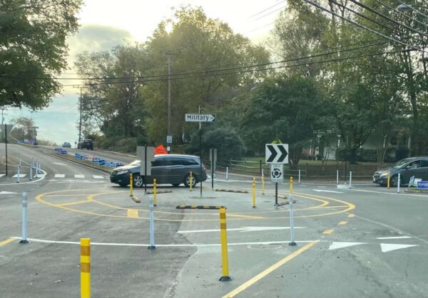
Arlington County has not ruled out the possibility of a permanent roundabout on Military Road despite the confusion a temporary version has caused for the past year.
In October 2021, where there used to be a stop sign for traffic on northbound Military Road, the county added paint lines, bollards and raised temporary curbs, and partially demolished a median. The work was aimed at improving safety where Military Road intersects with Nelly Custis Drive.
While preliminary data from the county found the roundabout did lower speeds, 53% of drivers, 27% of pedestrians and 26% of cyclists said they felt “less safe” or “much less safe” using the new traffic pattern, per a summary of feedback collected this summer.
“The majority of all respondents reported feeling less safe while using the pilot intersection, but the margins were very narrow for those who walked or biked through the intersection,” the report says. “Those who reported feeling less safe highlighted concerns with operational confusion, the size of the pilot roundabout and the perceived lack of sufficient space for a well-designed roundabout in the future condition.”
Drivers said they were confused about proper procedure in the intersection, while cyclists said drivers exhibited inconsistent behavior and would revert to habits they had when the intersection had a stop sign, per the report. Additionally, several users said the temporary materials caused visual challenges that contributed to the confusion.

About 31% of drivers, 26% of pedestrians and 18% of cyclists said they felt “safer” or “much safer” with the traffic circle, the summary says.
Road users in this camp were also concerned about confusion, but “reported better yield rates by vehicles to pedestrians, slower vehicle speeds, and easier operations for traffic flow and left turns from Military to Military,” the report said.
For now, it seems the roundabout is still in play as a permanent change.
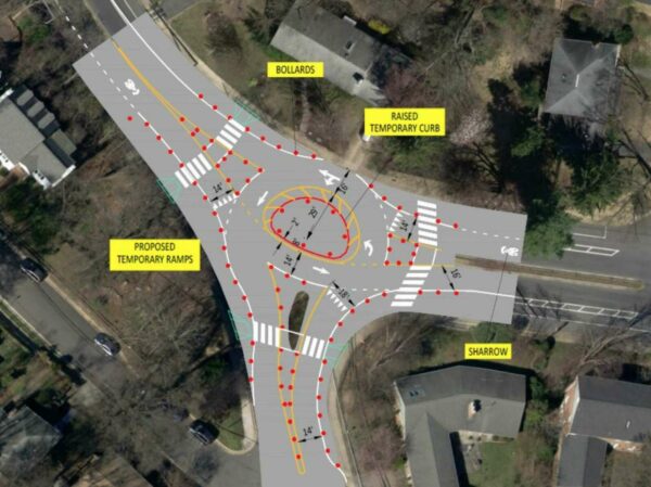
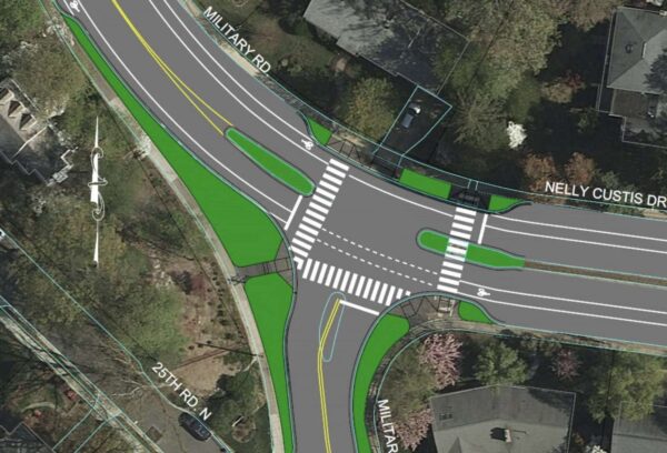
The report says that the project can “take the form of either a signalized intersection or a roundabout” and that a majority of issues locals raised “can be addressed through design in a capital project, where the intersection design will not be limited by existing curb lines.”
Meanwhile, the Old Glebe Civic Association, which previously called the changes “unwanted” and says it has opposed the potential project for four years, says it has sources claiming the roundabout is all but a done deal.
“Two County staff members recently stated that the County will be building a permanent roundabout, which will take about 12 to 15 months, independent of the public feedback,” writes Peter Jaffe in the October edition of OGCA’s newsletter. “They said that the permanent roundabout will be larger than the temporary one and that the increased size will help address confusion by drivers about who is in the roundabout and who has the right of way.”
The report notes that recently, signs in the middle of the roundabout “have been knocked down and later repaired at least twice, suggesting that incidents have occurred at the roundabout.” The Old Glebe neighborhood is about 2 miles west of the roundabout, but Military Road is a popular commuter route for those heading east.
In response to OGCA’s letter, Dept. of Environmental Services spokeswoman Claudia Pors tells ARLnow there is no official recommendation yet.
“The County has not shared any recommendation or decision for the Military Road and Nelly Custis Roundabout Pilot Project at this time,” she said.
As for the signage, she said the team at DES is aware of the issue.
“Throughout the pilot’s duration, signage has been knocked over,” she said. “Staff has repaired or replaced these signs as soon as possible. We do not have information on the exact causes of these incidents or how many times they occurred.”
Work to rebuild Army Navy Drive through Pentagon City and improve safety and transit along the corridor is officially underway.
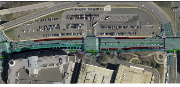
This morning, Arlington County and the Northern Virginia Transportation Authority ceremonially broke ground on the long-planned Army Navy Drive “Complete Street” Project, which is intended to make the current multi-lane expanse of Army Navy Drive between S. Joyce Street and 12th Street S. more friendly to pedestrians, cyclists and transit users.
The project includes shortened pedestrian crossings, dedicated transit lanes between S. Joyce Street and S. Hayes Street, planted medians, new traffic signals at five intersections, and in some places, narrowed or reduced vehicle travel lanes. There will be a protected, two-way bicycle lane along the south side of Army Navy Drive.
Work kicks off as the number of workers and residents in the area is projected to significantly increase in the coming years. Amazon is preparing to build the second phase of its HQ2 — known as PenPlace, and which includes the iconic “Helix” building — at the corner of Army Navy Drive and S. Eads Street, while continuing to hire toward its goal of 25,000 employees. Meanwhile, JBG Smith has filed plans to add 1,668 residential units to surface parking lots at the nearby RiverHouse complex.
For the next three weeks, road users will see signs of crews setting up for the Army Navy Drive project, like cones and a construction management trailer, says Mark Dennis, project manager for Arlington’s Dept. of Environmental Services. In mid-November, people will start to see demolition work.
“Both sides of the corridors will have markings and indicators that the entire area is a working construction zone,” Dennis told ARLnow. “There will be slight changes in traffic patterns to accommodate lane shifts that are needed.”
He said drivers will need to pay extra attention to navigate these changes.
Before scooping ceremonial dirt with gold-colored shovels, local and regional dignitaries celebrated the expected benefits of the project.
Arlington County Board Chair Katie Cristol said the project will make Army Navy Drive safer for pedestrians and cyclists and more convenient for bus riders. It will also slow down drivers, improve air quality and reduce stormwater runoff, she said.
“It’s better for all of us because providing safe, accessible and multimodal transportation is a key part of the economic competitiveness of Pentagon City and Arlington overall,” said Cristol.
NVTA CEO Monica Backmon celebrated the project for “getting people out of their single-occupancy vehicles and giving people options.”
https://twitter.com/NVTAuthority/status/1584554450823544832
The transportation authority said in a press release that it has invested more than $227 million into transportation projects located in Pentagon City, Crystal City and Potomac Yard, known collectively as National Landing.

