Update at 4:10 p.m. — That’s all folks. The storms have moved southeast, out of Arlington.
Update at 4:10 p.m. — N. Vance Street is reported to be blocked at Lee Highway due to a large branch in the roadway. Police are on scene.

Update at 4:10 p.m. — That’s all folks. The storms have moved southeast, out of Arlington.
Update at 4:10 p.m. — N. Vance Street is reported to be blocked at Lee Highway due to a large branch in the roadway. Police are on scene.
Arlington and surrounding areas are under a severe thunderstorm warning through 3:15 p.m. A line of strong storms is quickly approaching from the northwest.
* SEVERE THUNDERSTORM WARNING FOR… CITY OF ALEXANDRIA IN NORTHERN VIRGINIA… CITY OF FAIRFAX IN NORTHERN VIRGINIA… CITY OF FALLS CHURCH IN NORTHERN VIRGINIA… ARLINGTON COUNTY IN NORTHERN VIRGINIA… FAIRFAX COUNTY IN NORTHERN VIRGINIA…
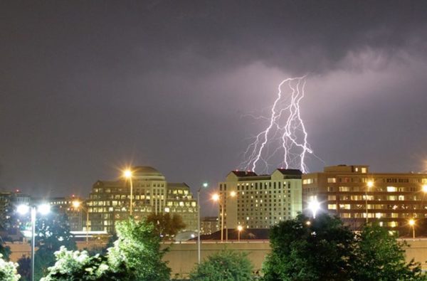
Despite ominous black clouds and frequent lightning, last night’s line of thunderstorms hit pretty much everywhere but Arlington.
Other than a few drops in Clarendon and a brief shower in Rosslyn, the storm managed to bypass Arlington completely. Nonetheless, the clouds and the natural light show made for some good photos. Here are a few sent to us by readers.

(Updated at 9:00 a.m.) Arlington and the rest of the D.C. region is under a heat advisory from noon to 8:00 p.m., as temperatures are expected to soar this afternoon.
Forecasters are predicting a high temperature of 96 degrees, with heat index values reaching into the 100s. Some forecasts even have the temperature hitting 100 today.
A severe thunderstorm watch has been issued for the D.C. region tonight.
A line of storms that caused severe damage in Chicago earlier today is quickly approaching the region from the west.
You’ll probably want to pack an umbrella this morning.
Numerous downpour-producing storms are expected to hit the Washington area this afternoon and evening. Forecasters are warning that the storms could cause flash flooding.

(Updated at 2:55 p.m.) Parts of Old Dominion Drive and Rock Spring Road remained closed this afternoon as crews continued to clean up from the “macroburst” storm that ravaged parts of North Arlington on Sunday.
The smell of freshly-cut wood and the sound of chainsaws and wood chippers was pervasive throughout Yorktown and the other hart-hit neighborhoods. Private disaster recovery trucks — along with crews from Dominion, Verizon and other utilities — roamed the streets, many of which are still covered with debris waiting to be hauled off.
Crews are still working to clean up toppled trees and tangled power lines left in the wake of the powerful storm that ripped through Arlington Sunday night.
The photo above depicts damage in the area of Glebe Road and Old Dominion Drive, in one of the county’s hardest-hit neighborhoods. As of 3:00 a.m., 1360 Dominion customers in North Arlington were still without power.
Arlington and much of the surrounding area is under a severe thunderstorm warning through 7:00 p.m.
Storms capable of torrential rain and damaging winds are quickly approaching Arlington and D.C. from the northwest.
As of 2:30 a.m., 1,734 Dominion customers were without power in Arlington. The outage was said to be centered in the Courthouse and Clarendon area, along Wilson and Clarendon Boulevards.
In addition to restaurants and commercial offices, the outage also hit county government buildings in Courthouse. Some of the county’s internal computer networks were said to have been knocked offline by the outage. Firefighters responded to the county jail after the emergency generator reportedly failed to start, leaving the facility in the dark.
The sweltering temperatures have prompted organizers of both the Ballston Farmers Market — held every Thursday in Welburn Square — and the Rosslyn Farmers Market — held Thursdays at the corner of Wilson Boulevard and N. Oak Street — to cancel.
Temperatures are expected to come close to the 100 degree mark today.
The mercury is expected to flirt with 100 degrees today as a heat wave envelops the region. Tomorrow will bring more of the same heat and humidity — but with a better chance of hitting 100.
If you’ve lived through just one summer in the D.C. area, this is nothing new. In fact, there’s an excellent chance that it will get even hotter at some point this summer.