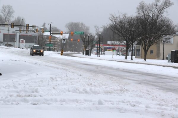
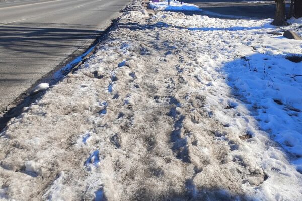
For the first time in nearly three years, Arlington experienced a significant snowfall.
Starting very early yesterday morning and finally tapering off in afternoon, preliminary estimates suggest that the county got close to seven inches of snow.
The storm brought power outages, closures, the suspension of bus service, cancellation of trash pick-up, and numerous skidding cars.
It was a very bad day to be on the roads, with the Arlington and VDOT crews unable to pre-treat the streets because the storm started off as rain.
It's been a hot minute since our area has seen accumulating snow like this, so we wanted to give a little refresher to those who haven't gotten their "snow legs" back just yet… 😉 pic.twitter.com/vwjbPdbxom
— VDOT Northern VA (@VaDOTNOVA) January 3, 2022
As of Tuesday morning, Arlington County snow crews — their ranks thinned by Covid absences — were tackling neighborhood streets after spending most of Monday treating and clearing main roads.
Phase 3 of cleanup will continue throughout the day, particularly on residential streets. A window of afternoon temps above freezing will help. Will be a great opportunity to shovel any sidewalks that weren't cleared yesterday. https://t.co/DuInmAUGlm #ArlWX pic.twitter.com/9GKyL8Rl6X
— Arlington Department of Environmental Services (@ArlingtonDES) January 4, 2022
Despite the challenges, with everything that the region has been dealing with lately, the snow also brought a considerable amount of joy to some.
“I love it,” Javed Malik told ARLnow, peering up at the falling flakes at Penrose Square. “It’s a beautiful, gorgeous day.”
In Ballston, kids and adults alike were spotted pulling sleds to the nearest hill. Pedestrians were reclaiming the covered streets as their own, snapping selfies and looking up at the snowy sky.
Persi George, from California, had never seen anything like it in person before.
“I’ve seen it before in the movies,” she said with a laugh standing in front of her apartment building along Columbia Pike. It’s a little softer than she expected, but that doesn’t dampen her enthusiasm as she prepares to make her first snow angel. “I’m in love with it.”
Yesterday was also set to be the first day back to school after the long holiday break with Arlington Public Schools continuing to commit to in-person instruction. That didn’t happen because the storm cancelled classes across Arlington and the region. School is cancelled today, too, with an expected refreezing overnight.
At least one teacher is breathing a sigh of relief. With Covid cases on the rise, likely due to holiday gatherings, the two extra days off provides more time for students to get tested.
“This couldn’t have been more well-timed. Coming back from the break, we are all worried about the rising case numbers,” Arlington high school teacher Josh Folb told ARLnow. “Hopefully, this gives people more time to get tested and… isolate, if needed. I haven’t talked to a teacher yet, and I’ve talked to a lot today, that isn’t grateful [about the snow days].”
There remains a chance it will snow again this week, Thursday night to Friday morning, though it’s not expected to dump as much snow as Monday’s storm.
After Arlington’s biggest snowfall since early 2019, the continued winter weather hasn’t been kind to some Columbia Pike businesses already dealing with a pandemic.
Along the Pike, sidewalks remained covered in snow, slush, and salt — as sleet intermediately fell from the sky earlier this afternoon.
A Winter Weather Advisory remains in effect until Tuesday morning and a mixture of sleet, freezing rain, and snow is expected to continue throughout the day and into the evening.
Sofonias Gebretsadick, co-owner of Idido’s Coffee near the intersection of Columbia Pike and Walter Reed Drive, says that the poor weather has impacted his business.
“Sunday… and today, it’s slow,” Gebretsadick tells ARLnow. “When the weather isn’t good, we don’t have much foot traffic.”
This is the coffee shop’s first time experiencing measurable snow. It opened in late February 2019, a week after the last time Arlington had at least two inches of snow.
In general, he says, winter has been his least profitable season, but last year’s warmer winter muted the impact.
Of course this past year, right when the weather turned, the pandemic hit. It was a rough March and April, Gebretsadick says, but summer sales were much better.
This winter, between the cold, continued high number of COVID-19 cases, and now the weather, that hasn’t remained the case, he said.
Down the Pike, Burritos Bros was also seeing a decline in normal business due to the snow and ice.
At about 12:30 p.m., the normal steady stream of lunch customers — which has remained even during the pandemic — were nowhere to be found at the local burrito stand, located in a CVS parking lot.
Co-owner Richard Arnez says that between 11 a.m. and 2 p.m. is when they typically get customers. But not today.
“It’s been a lot slower today because of the weather,” he says pointing out the window.
He lives near Annandale and said the commute to Arlington this morning wasn’t bad, as the roads were clear of both snow and traffic.
Arnez, too, says while his business has adjusted, the pandemic has continued to take a bite out of the restaurant’s business. And winter weather is certainly not helping.
Back at Idido’s, a bag of salt sits at the door. Despite being cleared earlier, Gebretsadick said the continued precipitation all day has built up a layer of ice on the sidewalk that’s hard to remove. He put down salt himself and is already onto bag number two from Costco.
Gebretsadick went outside in the snow for a bit yesterday with his kids at his Maryland home. They had fun, he says, while he sipped coffee.
But, then, it was back to work today.
As some Arlingtonians are still struggling to put their lives together after flash flooding in July, the county is continuing to work to repair flood-damaged public property.
Early estimates put damage to the county at $3.5 million, but Hannah Winant, a spokesperson for Arlington County Public Safety Communications and Emergency Management, said estimates for the damage to county property has swelled to $5.8 million. Those costs include debris cleanup, emergency protective measures, and repairs to County facilities like parks and community centers.
Winant said bridges in Lubber Run and Glencarlyn parks suffered the worst damage from the storms. A storage building at Bon Air park was also seriously damaged, as were other pedestrian bridges, playgrounds and more across Arlington. Additionally, the County is assessing the erosion to local waterways that could require long-term fixes.
Arlington has submitted its preliminary assessment to the state, but after the state receives the assessment it must be validated.
“This process can go on for a few weeks, as crews triage the damage and more information becomes available,” Winant said. “This is where we are now.”
Once the state completes its assessment, that information is submitted to the Federal Emergency Management Agency (FEMA), after which the agency portions out funding and technical support for public properties that have been damaged.
“Reimbursement is also being sought through the County’s insurance,” Winant said. “During this time, the County cleans up from the disaster, removing the debris and cleaning right-of-way, and tries to get back to normal operations for the community such as opening parks and other affected facilities. The recovery process can be a long one and we appreciate the community’s patience and support as we navigate the process of requesting aid.”
Going forward, Winant predicted recovery costs will continue to increase as weather changes become more severe.
“Weather is consistently increasing in its severity and frequency,” Winant said “Nationally, both insured and uninsured losses continue to grow — so costs from disasters are rising as disaster frequency also increases.”
For homeowners, businesses, and renters who were affected by the flooding, the Small Business Administration is offering low-interest loans. The filing deadline for physical property damage is Oct. 7, and the deadline for economic injury applications from business owners is May 7, 2020.
This week’s devastating flash floods may be evidence of a bigger weather pattern shift, some experts say.
The storm that pummeled the Arlington dumped 3.3 inches of rain in one hour Monday morning, breaking the regional record. Some experts say this is part of a larger pattern of wetter weather — and possibly climate change.
The so-called supercell developed in Frederick County, Virginia, where NWS Meteorologist Jason Elliott says cool, dry winds from the north met with warm, wet winds from the south. From there the storm — which was about the side of Montgomery County, Md. — travelled about 20 miles per hour towards southern Maryland.
Unfortunately for Arlington, the heaviest part of the storm travelled down the Potomac River — straight through Fairfax County, Arlington County, Alexandria and D.C. — overwhelming stormwater management systems and filling streets, homes, and businesses with water.
When a rainstorm hits, the runoff water not absorbed into the ground travels into the county’s stormwater pipes. However, too much water can fill the pipes, and flow out of manholes and storm drains.
“Water will then flow underneath of a road or a bridge and a stream will fill up and flow on top of a road or culvert,” said Aileen Winquist, Arlington’s Stormwater Management Program Manager. “That’s where damage can occur.”
Monday’s storm not only turned streams and streets into raging rapids, but also caused sewage backups in homes. Winquist said this is usually caused by water flooding sewer pipes and coming up through the floor drains in basements. It’s a problem residents in Westover and elsewhere face as they continue to recover from the flooding.
The county’s storm and sewer systems are overall in “good condition”, Winquist said, and crews continuing to repair corroded storm pipes and re-line old sewer pipes as needed.
“Typically the storm sewer system is designed for what’s known as a 10 year storm,” she added, referring the federal classification of a storm that has a 10% chance of occurring once every 10 years.
“It was easily raining 5 inches in an an hour, for half an hour,” said Elliot. “And nothing can handle something that heavy in that short a period of time.”
The county keeps a detailed map of every location in Arlington damaged in a flood and uses it prepare for future emergencies and prioritize routine repairs. Winquist declined to share a copy of the map, citing privacy concerns, but noted that Westover was not among the neighborhoods filled with water during Arlington’s last major flood back in 2006.
New flood plains can be caused by a variety of factors, such as problems with the storm water pipes or nearby development projects. But there’s also the issue of storms getting stronger and wetter.
Prepare for more rain, and more flooding, the National Weather Service warns.
The NWS has issued a severe thunderstorm watch through 10 p.m. tonight, with a flash flood watch as well from 3 p.m. to 11 p.m. due to the excessive amounts of rain the region’s seen recently.
Showers and thunderstorms are expected this afternoon and evening as a cold front approaches the area. Both severe weather and flash flooding will be possible in association with these storms. For additional details visit https://t.co/o2JIHfMyKQ pic.twitter.com/JRDudNNHFT
— NWS DC/Baltimore (@NWS_BaltWash) July 27, 2018
Full details from the NWS:
…FLASH FLOOD WATCH REMAINS IN EFFECT FROM 3 PM EDT THIS
AFTERNOON THROUGH THIS EVENING…The Flash Flood Watch continues for
* Portions of Maryland, The District of Columbia, and Virginia,
including the following areas, in Maryland, Anne Arundel,
Carroll, Central and Southeast Howard, Central and Southeast
Montgomery, Charles, Northern Baltimore, Northwest Harford,
Northwest Howard, Northwest Montgomery, Prince Georges,
Southeast Harford, and Southern Baltimore. The District of
Columbia. In Virginia, Arlington/Falls Church/Alexandria,
Eastern Loudoun, Fairfax, King George, Prince
William/Manassas/Manassas Park, and Stafford.* From 3 PM EDT this afternoon through 11 PM EDT this evening.
* Showers and thunderstorms are expected to develop late this
afternoon and evening, with heavy rainfall rates likely. Given
saturated soil from this week`s excessive rainfall, any
additional heavy rain or repetitive thunderstorms may result in
rapid rises of water in streams and low lying areas.PRECAUTIONARY/PREPAREDNESS ACTIONS…
A Flash Flood Watch means that conditions may develop that lead
to flash flooding. Flash flooding is a very dangerous situation.You should monitor later forecasts and be prepared to take action
should Flash Flood Warnings be issued.
Photo via @NWS_BaltWash
Following days of relentless rain, a series of sinkholes have opened up in front of a condo complex in Rosslyn.
The front driveway and lawn of the Atrium Condominiums, located at 1530 Key Blvd, are now marked by the large pits. Two holes several feet deep have opened up around some of the complex’s front lawn, and another has caused cobblestones to buckle leading up to its driveway in front of the main entrance.
Traffic cones currently block off the complex’s driveway, including parts of it unaffected by the pits.
A tipster told ARLnow that the sinkholes first appeared “many weeks ago” and have “gradually grown as more rain has come” over the last few days.
The complex’s management company did not immediately respond to a request for comment on the severity of the sinkholes, or when they might be fixed.
A perilously perched tree has prompted the temporary closure of a playground near East Falls Church.
The severe rain storms of the last few days has caused a “tree-mergency” in Madison Manor Park (6225 12th Street N.).
Susan Kalish, a spokeswoman for the county’s Department of Parks and Recreation, says the rain managed to so thoroughly soak the ground at the park that the tree eventually tipped over. She says workers will be removing it “first thing” tomorrow morning (Thursday).
“After they have finished, parks crew will clean up any mess and refasten a section of fence that has been removed,” Kalish wrote in an email. “None of the play equipment has been damaged. One section of the perimeter timber has been dislodged by the tree’s roots and will have to be repaired once the tree is removed.”
Kalish said the county hopes to reopen the playground by “close of business tomorrow,” or Friday morning at the latest.
Parks and recreation workers plan to announce exactly when it will re-open on the department’s Twitter account.
Photo via @arlparksrec
Flash Flood Watch Remains, Though Rain is Subsiding — Weather watchers warn that a risk of floods remains through this afternoon, but things are set to get steadily dryer as Thursday and Friday get closer. [NWS]
Are Tolls Worth It on Virginia’s HOT Lanes? — A new study shows it’s a bit of a mixed bag for commuters, though anyone hopping on I-66 instead of Route 29 or Route 50 is probably getting their money’s worth. Researchers don’t see those arterial roads as viable alternatives, given the time savings 66 still offers during rush hour. [WTOP]
Metro Remains Less-Than-Ideal for Blind Riders — Months after a blind woman fell off a platform due to problems with Metro’s new 7000-series trains, the transit service is still scrambling to improve conditions for the visually impaired. [Washington Post]
Nearby: A Tornado Touched Down Near Thomas Jefferson High School — Officials believe a twister made a roughly one-minute-long appearance near the school, around the border of Alexandria and Annandale. [Washington Post]
Flickr pool photo via wolfkann
Keep an eye on the roads — the National Weather Service has issued a flood warning for Arlington through 6:30 p.m. tonight (Tuesday).
The weather service estimates the D.C. region could see up to two inches of rain in total tonight, though storms are supposed to move out of the area quickly.
The flooding has already prompted some road closures, including on the G.W. Parkway, which county police say is closed in both directions:
#Update: Water Rescue team has removed all the stranded pedestrians from their vehicles. pic.twitter.com/uXveBS3bOe
— Arlington Fire (@ArlingtonVaFD) July 17, 2018
@OhMyGOFF @amelia_draper @dougkammerer GW Parkway at DCA pic.twitter.com/iIEc1d0ASe
— David Earle (@dearle12) July 17, 2018
The intersection of Columbia Pike at S. Greenbrier Street is closed due to standing water. A floor warning has been issued for Arlington County until 6:30 p.m. It is NEVER safe to drive or walk into flood waters. If you see standing water, turn around don't drown. pic.twitter.com/lJNj6kpPuL
— ArlingtonCountyPD (@ArlingtonVaPD) July 17, 2018
More from the NWS:
The National Weather Service in Sterling Virginia has issued a
* Flood Warning for…
The central District of Columbia…Arlington County in northern Virginia…
Southeastern Fairfax County in northern Virginia…
The City of Alexandria in northern Virginia…* Until 630 PM EDT.
* At 329 PM EDT, Doppler radar indicated thunderstorms producing
heavy rain which will cause flooding. Up to one inch of rain has
already fallen. Additional rainfall amounts of up to one inch are
possible.* Some locations that may experience flooding include…
Arlington, Alexandria, Annandale, Springfield, Fort Washington,
Fort Hunt, Groveton, Falls Church, Huntington, Mantua, Fort
Belvoir, Nationals Park, Gallaudet University, Reagan National
Airport, Rosslyn, Crystal City, RFK Stadium, Burke, Lincolnia and
Lorton.
(Updated at 7:35 p.m.) Friday’s wind storm has taken a toll on Arlington, sending trees toppling onto cars, houses and across roads, and knocking out power to tens of thousands.
As of 7:30 p.m., Dominion reported 14,663 customers without power in Arlington. An hour earlier, it appeared that the numbers were finally dropping, but thanks to continued strong winds it has, in fact, gone up.
A Dominion outage map showed that a large swath of residential North Arlington and a significant portion of the Fairlington neighborhood was without power as the sun started to set.
Across the D.C. region, nearly 600,000 were in the dark as of early evening.
Arlington County Police say they’ve responded to more than 250 calls for service since this morning, including 66 calls for trees down.
Since 7 AM, our dedicated officers have responded to over 250 calls for service. Those calls include the following related to the storm:
Trees down = 66
Traffic signal outages = 17
Traffic issues = 53— ArlingtonCountyPD (@ArlingtonVaPD) March 3, 2018
To help with the cleanup, which is expected to take at least a few days, Virginia Gov. Ralph Northam has declared a state of emergency.
“The order is designed to help Virginia mitigate any damage caused by high winds and to streamline the process that the Commonwealth uses to provide assistance to communities impacted,” the governor’s office said in a statement.
A High Wind Warning remains in effect until 6 a.m. Gusty winds are expected to continue overnight as the nor’easter makes its way north and pummels New England.
The National Weather Service says it clocked a wind gust of 71 miles per hour at Dulles International Airport earlier today. NWS is urging those in the D.C. area to remain vigilant as the winds continue to gust.
Widespread power outages are occurring. Travel is dangerous, especially for high profile vehicles, and motorists need to be aware of rapidly changing road conditions due to the potential of downed trees and power lines. Pedestrians will face very hazardous conditions, and need to be aware of wind-borne projectiles. People should avoid being outside in forested areas and around trees and branches. If possible, remain in the lower levels of your homes during the windstorm, and avoid windows. If you use a portable generator, follow manufacturer’s instructions and do not use inside homes, garages, or apartments.
More local weather impacts via social media, after the jump.
High winds are expected to wallop the Washington region tonight through Saturday and officials are asking the public to take precautions.
Wind gusts as strong as 60-70 miles per hour are possible from Friday from 4 a.m. through midnight, forecasters say. Wind gusts over 30 miles per hour are expected generally from tonight into Sunday.
The Virginia Department of Transportation issued its own advisory, warning that roadways could be dangerous and that road closures could be possible due to downed trees and power lines or other road debris. Crews will begin working overnight to fix any infrastructure damage, the agency said.
VDOT issued a warning to drivers, and a reminder to:
- Check road closures before you travel, and look at potential alternate routes.
- Reduce your speeds and assume there may be a road obstruction ahead.
- Move over for responders with blue, red, and amber lights, including VDOT and utility crews.
- Always use your headlights, remember wipers on, lights on is the law.
- Ensure gas tanks are full, and have a good emergency kit. Here’s how: www.ready.gov/car.
AAA Mid-Atlantic issued its own warning, including a reminder to treat non-working traffic signals as a four-way stop.
“Motorists who venture out during the Nor’easter should brace themselves for driving into tempestuous side winds, which would buffet them off course and off the road, and into blustery head winds and turbulent tail winds,” AAA said. “Drive defensively or stay off the roads until the mercurial storm passes over.”
More advisories from the agencies via social media:
https://twitter.com/VaDOTNOVA/status/969252081319202816
Dangerously strong, and long-lasting winds coming – starting at, or soon after, midnight. Here's what to expect, & some actions to take to be ready. pic.twitter.com/OBKdiMEg1g
— NWS DC/Baltimore (@NWS_BaltWash) March 1, 2018
Heavy winds expected overnight and tomorrow. https://t.co/BCxWKRKkw7 pic.twitter.com/VooD1KD38m
— Arlington DES (@ArlingtonDES) March 1, 2018
https://twitter.com/ReadyArlington/status/969322520582205440
https://twitter.com/ArlingtonVaPD/status/969329658037760000
File photo